Report on Semeru (Indonesia) — April 2020

Bulletin of the Global Volcanism Network, vol. 45, no. 4 (April 2020)
Managing Editor: Edward Venzke.
Edited by Kadie L. Bennis.
Semeru (Indonesia) Ash plumes and thermal anomalies continue during September 2019-February 2020
Please cite this report as:
Global Volcanism Program, 2020. Report on Semeru (Indonesia) (Bennis, K.L., and Venzke, E., eds.). Bulletin of the Global Volcanism Network, 45:4. Smithsonian Institution. https://doi.org/10.5479/si.GVP.BGVN202004-263300
Semeru
Indonesia
8.108°S, 112.922°E; summit elev. 3657 m
All times are local (unless otherwise noted)
Semeru is a stratovolcano located in East Java, Indonesia containing an active Jonggring-Seloko vent at the Mahameru summit. Common activity has consisted of ash plumes, pyroclastic flows and avalanches, and lava flows that travel down the SE flank. This report updates volcanism from September 2019 to February 2020 using primary information from the Pusat Vulkanologi dan Mitigasi Bencana Geologi (PVMBG, also known as Indonesian Center for Volcanology and Geological Hazard Mitigation, CVGHM) and the Darwin Volcanic Ash Advisory Centre (VAAC).
The dominant activity at Semeru for this reporting period consists of ash plumes, which were frequently reported by the Darwin VAAC. An eruption on 10 September 2019 produced an ash plume rising 4 km altitude drifting WNW, as seen in HIMAWARI-8 satellite imagery. Ash plumes continued to rise during 13-14 September. During the month of October the Darwin VAAC reported at least six ash plumes on 13, 14, 17-18, and 29-30 October rising to a maximum altitude of 4.6 km and moving primarily S and SW. Activity in November and December was relatively low, dominated mostly by strong and frequent thermal anomalies.
Volcanism increased in January 2020 starting with an eruption on 17 and 18 January that sent a gray ash plume up to 4.6 km altitude (figure 38). Eruptions continued from 20 to 26 January, producing ash plumes that rose up to 500 m above the crater that drifted in different directions. For the duration of the month and into February, ash plumes occurred intermittently. On 26 February, incandescent ejecta was ejected up to 50 m and traveled as far as 1000 m. Small sulfur dioxide emissions were detected in the Sentinel 5P/TROPOMI instrument during 25-27 February (figure 39). Lava flows during 27-29 February extended 200-1,000 m down the SE flank; gas-and-steam and SO2 emissions accompanied the flows. There were 15 shallow volcanic earthquakes detected on 29 February in addition to ash emissions rising 4.3 km altitude drifting ESE.
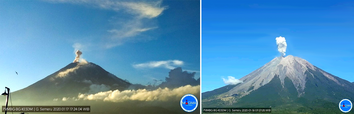 |
Figure 38. Ash plumes rising from the summit of Semeru on 17 (left) and 18 (right) January 2020. Courtesy of MAGMA Indonesia and via Ø.L. Andersen's Twitter feed (left). |
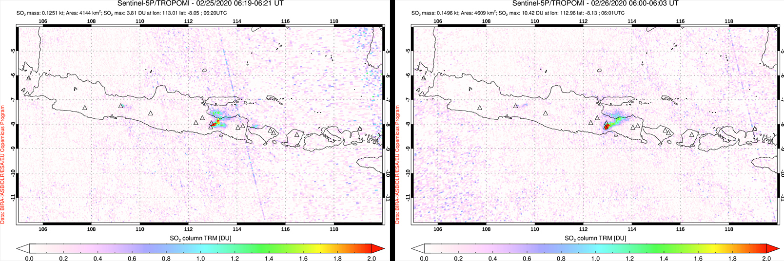 |
Figure 39. Small SO2 plumes from Semeru were detected by the Sentinel 5P/TROPOMI instrument during 25 (left) and 26 (right) February 2020. Courtesy of NASA Goddard Space Flight Center. |
MIROVA (Middle InfraRed Observation of Volcanic Activity) analysis of MODIS satellite data showed relatively weak and intermittent thermal anomalies occurring during May to August 2019 (figure 40). The frequency and power of these thermal anomalies significantly increased during September to mid-December 2019 with a few hotspots occurring at distances greater than 5 km from the summit. These farther thermal anomalies to the N and NE of the volcano do not appear to be caused by volcanic activity. There was a brief break in activity during mid-December to mid-January 2020 before renewed activity was detected in early February 2020.
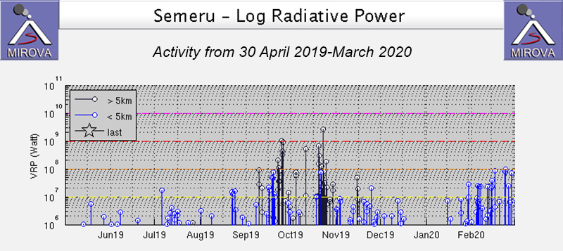 |
Figure 40. Thermal anomalies were relatively weak at Semeru during 30 April 2019-August 2019, but significantly increased in power and frequency during September to early December 2019. There was a break in activity from mid-December through mid-January 2020 with renewed thermal anomalies around February 2020. Courtesy of MIROVA. |
The MODVOLC algorithm detected 25 thermal hotspots during this reporting period, which took place during 25 September, 18 and 21 October 2019, 29 January, and 11, 14, 16, and 23 February 2020. Sentinel-2 thermal satellite imagery shows intermittent hotspots dominantly in the summit crater throughout this reporting period (figure 41).
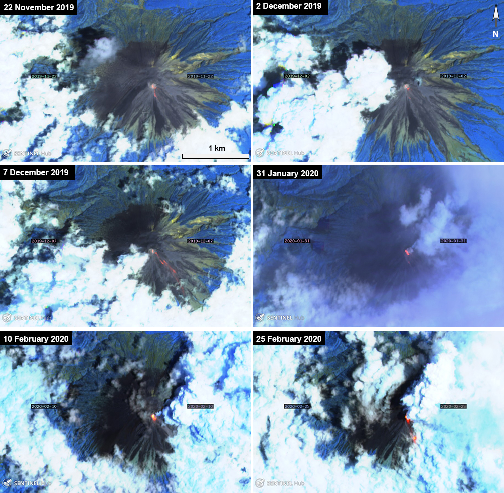 |
Figure 41. Sentinel-2 thermal satellite imagery detected intermittent thermal anomalies (bright yellow-orange) at the summit of Semeru, which included some lava flows in late January to early February 2020. Sentinel-2 atmospheric penetration (bands 12, 11, 8A) images courtesy of Sentinel Hub Playground. |
Geological Summary. Semeru, the highest volcano on Java, and one of its most active, lies at the southern end of a volcanic massif extending north to the Tengger caldera. The steep-sided volcano, also referred to as Mahameru (Great Mountain), rises above coastal plains to the south. Gunung Semeru was constructed south of the overlapping Ajek-ajek and Jambangan calderas. A line of lake-filled maars was constructed along a N-S trend cutting through the summit, and cinder cones and lava domes occupy the eastern and NE flanks. Summit topography is complicated by the shifting of craters from NW to SE. Frequent 19th and 20th century eruptions were dominated by small-to-moderate explosions from the summit crater, with occasional lava flows and larger explosive eruptions accompanied by pyroclastic flows that have reached the lower flanks of the volcano.
Information Contacts: Pusat Vulkanologi dan Mitigasi Bencana Geologi (PVMBG, also known as Indonesian Center for Volcanology and Geological Hazard Mitigation, CVGHM), Jalan Diponegoro 57, Bandung 40122, Indonesia (URL: http://www.vsi.esdm.go.id/); MAGMA Indonesia, Kementerian Energi dan Sumber Daya Mineral (URL: https://magma.vsi.esdm.go.id/); Darwin Volcanic Ash Advisory Centre (VAAC), Bureau of Meteorology, Northern Territory Regional Office, PO Box 40050, Casuarina, NT 0811, Australia (URL: http://www.bom.gov.au/info/vaac/); MIROVA (Middle InfraRed Observation of Volcanic Activity), a collaborative project between the Universities of Turin and Florence (Italy) supported by the Centre for Volcanic Risk of the Italian Civil Protection Department (URL: http://www.mirovaweb.it/); Hawai'i Institute of Geophysics and Planetology (HIGP) - MODVOLC Thermal Alerts System, School of Ocean and Earth Science and Technology (SOEST), Univ. of Hawai'i, 2525 Correa Road, Honolulu, HI 96822, USA (URL: http://modis.higp.hawaii.edu/); Sentinel Hub Playground (URL: https://www.sentinel-hub.com/explore/sentinel-playground); Global Sulfur Dioxide Monitoring Page, Atmospheric Chemistry and Dynamics Laboratory, NASA Goddard Space Flight Center (NASA/GSFC), 8800 Greenbelt Road, Goddard, Maryland, USA (URL: https://so2.gsfc.nasa.gov/); Øystein Lund Andersen (Twitter: @OysteinLAnderse, https://twitter.com/OysteinLAnderse, URL: http://www.oysteinlundandersen.com).