Report on Santa Maria (Guatemala) — April 2020

Bulletin of the Global Volcanism Network, vol. 45, no. 4 (April 2020)
Managing Editor: Edward Venzke.
Edited by A. Elizabeth Crafford.
Santa Maria (Guatemala) Daily explosions with ash plumes and block avalanches continue, September 2019-February 2020
Please cite this report as:
Global Volcanism Program, 2020. Report on Santa Maria (Guatemala) (Crafford, A.E., and Venzke, E., eds.). Bulletin of the Global Volcanism Network, 45:4. Smithsonian Institution. https://doi.org/10.5479/si.GVP.BGVN202004-342030
Santa Maria
Guatemala
14.757°N, 91.552°W; summit elev. 3745 m
All times are local (unless otherwise noted)
The dacitic Santiaguito lava-dome complex on the W flank of Guatemala's Santa María volcano has been growing and actively erupting since 1922. Ash explosions, pyroclastic, and lava flows have emerged from Caliente, the youngest of the four vents in the complex, for more than 40 years. A lava dome that appeared within the summit crater of Caliente in October 2016 has continued to grow, producing frequent block avalanches down the flanks. Daily explosions with ash plumes and block avalanches continued during September 2019-February 2020, the period covered in this report, with information primarily from Guatemala's INSIVUMEH (Instituto Nacional de Sismologia, Vulcanologia, Meterologia e Hidrologia) and the Washington VAAC (Volcanic Ash Advisory Center).
Constant fumarolic activity with steam and gas persisted from the Caliente dome throughout September 2019-February 2020. Explosions occurred multiple times per day, producing ash plumes that rose to altitudes of 3.1-3.5 km and usually drifted a few kilometers before dissipating. Several lahars during September and October carried volcanic blocks, ash, and debris down major drainages. Periodic ashfall was reported in communities within 10 km of the volcano. An increase in thermal activity beginning in November (figure 101) resulted in an increased number of observations of incandescence visible at night from the summit of Caliente through February 2020. Block avalanches occurred daily on the flanks of the dome, often reaching the base, stirring up small clouds of ash that drifted downwind.
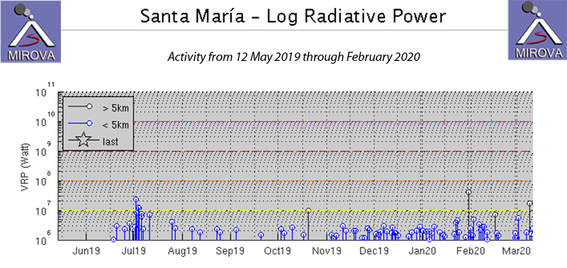 |
Figure 101. The MIROVA project graph of thermal activity at Santa María from 12 May 2019 through February 2020 shows a gradual increase in thermal energy beginning in November 2019. This corresponds to an increase in the number of daily observations of incandescence at the summit of the Caliente dome during this period. Courtesy of MIROVA. |
Constant steam and gas fumarolic activity rose from the Caliente dome, drifting W, usually rising to 2.8-3.0 km altitude during September 2019. Multiple daily explosions with ash plumes rising to 2.9-3.4 km altitude drifted W or SW over the communities of San Marcos, Loma Linda Palajunoj, and Monte Claro (figure 102). Constant block avalanches fell to the base of the cone on the NE and SE flanks. The Washington VAAC reported an ash plume visible in satellite imagery on 10 September at 3.1 km altitude drifting W. On 14 September another plume was spotted moving WSW at 4.6 km altitude which dissipated quickly; the webcam captured another plume on 16 September. Ashfall on 27 September reached about 1 km from the volcano; it reached 1.5 km on 29 September. Lahars descended the Rio Cabello de Ángel on 2 and 24 September (figure 102). They were about 15 m wide, and 1-3 m deep, carrying blocks 1-2 m in diameter.
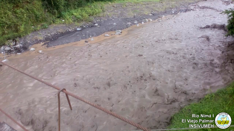 |
Figure 102. A lahar descended the Rio Cabello de Ángel at Santa Maria and flowed into the Rio Nima 1 on 24 September 2019. Courtesy of INSIVUMEH (Reporte Semanal de Monitoreo: Volcán Santiaguito (1402-03), Semana del 21 al 27 de septiembre de 2019). |
Througout October 2019, degassing of steam with minor gases occurred from the Caliente summit, rising to 2.9-3.0 km altitude and generally drifting SW. Weak explosions took place 1-5 times per hour, producing ash plumes that rose to 3.2-3.5 km altitude. Ashfall was reported in Monte Claro on 2 October. Nearly constant block avalanches descended the SE and S flanks, disturbing recent layers of fine ash and producing local ash clouds. Moderate explosions on 11 October produced ash plumes that rose to 3.5 km altitude and drifted W and SW about 1.5 km towards Río San Isidro (figure 103). The following day additional plumes drifted a similar distance to the SE. The Washington VAAC reported an ash emission visible in satellite imagery at 4.9 km altitude on 13 October drifting NNW. Ashfall was reported in Parcelamiento Monte Claro on 14 October. Some of the block avalanches observed on 14 October on the SE, S, and SW flanks were incandescent. Ash drifted 1.5 km W and SW on 17 October. Ashfall was reported near la finca Monte Claro on 25 and 28 October. A lahar descended the Río San Isidro, a tributary of the Río El Tambor on 7 October carrying blocks 1-2 m in diameter, tree trunks, and branches. It was about 16 m wide and 1-2 m deep. Additional lahars descended the rio Cabello de Angel on 23 and 24 October. They were about 15 m wide and 2 m deep, and carried ash and blocks 1-2 m in diameter, tree trunks, and branches.
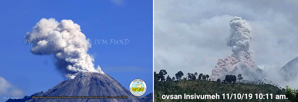 |
Figure 103. Daily ash plumes were reported from the Caliente cone at Santa María during October 2019, similar to these from 30 September (left) and 11 October 2019 (right). Courtesy of INSIVUMEH (Reporte Semanal de Monitoreo: Volcán Santiaguito (1402-03), Semana del 28 de septiembre al 04 de octubre de 2019; Reporte Semanal de Monitoreo: Volcán Santiaguito (1402-03), Semana del 05 al 11 de octubre de 2019). |
During November 2019, steam plumes rose to 2.9-3.0 km altitude and generally drifted E. There were 1-3 explosions per hour; the ash plumes produced rose to altitudes of 3.1-3.5 km and often drifted SW, resulting in ashfall around the volcanic complex. Block avalanches descended the S and SW flanks every day. On 4 November ashfall was reported in the fincas (ranches) of El Faro, Santa Marta, El Viejo Palmar, and Las Marías, and the odor of sulfur was reported 10 km S. Incandescence was observed at the Caliente dome during the night of 5-6 November. Ash fell again in El Viejo Palmar, fincas La Florida, El Faro, and Santa Marta (5-6 km SW) on 7 November. Sulfur odor was also reported 8-10 km S on 16, 19, and 22 November. Fine-grained ash fell on 18 November in Loma Linda and San Marcos Palajunoj. On 29 November strong block avalanches descended in the SW flank, stirring up reddish ash that had fallen on the flanks (figure 104). The ash drifted up to 20 km SW.
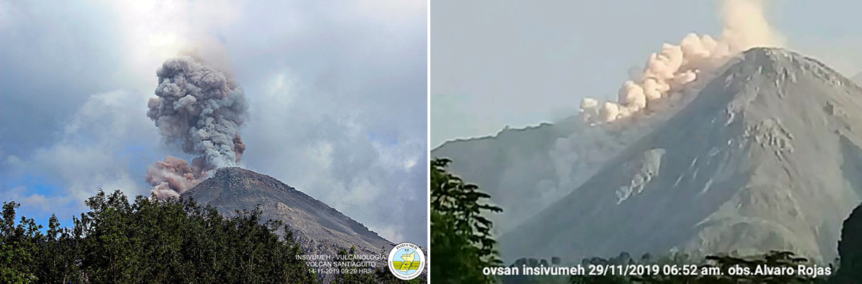 |
Figure 104. Ash plumes rose from explosions multiple times per day at Santa Maria’s Santiaguito complex during November 2019, and block avalanches stirred up reddish clouds of ash that drifted for many kilometers. Courtesy of INSIVUMEH. Left, 11 November 2019, from Reporte Semanal de Monitoreo: Volcán Santiaguito (1402-03), Semana del 09 al 15 de noviembre de 2019. Right, 29 November 2019 from BOLETÍN VULCANOLÓGICO ESPECIAL BESTG# 106-2019, Guatemala 29 de noviembre de 2019, 10:50 horas (Hora Local). |
White steam plumes rising to 2.9-3.0 km altitude drifted SE most days during December 2019. One to three explosions per hour produced ash plumes that rose to 3.1-3.5 km altitude and drifted W and SW producing ashfall on the flanks. Several strong block avalanches sent material down the SW flank. Ash from the explosions drifted about 1.5 km SW on 3 and 7 December. The Washington VAAC reported a small ash emission that rose to 4.9 km altitude and drifted WSW on 8 December, and another on 13 December that rose to 4.3 km altitude. Ashfall was reported up to 10 km S on 24 December. Incandescence was reported at the dome by INSIVUMEH eight times during the month, significantly more than during the recent previous months (figure 105).
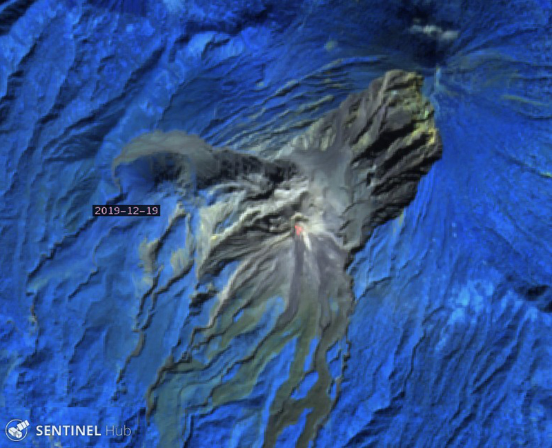 |
Figure 105. Strong thermal anomalies were visible in Sentinel-2 imagery at the summit of the Caliente cone at Santa María’s Santiaguito’s complex on 19 December 2019. Image uses Atmospheric Penetration rendering (bands 12, 11, 8A). Courtesy of Sentinel Hub Playground. |
Activity during January 2020 was similar to that during previous months. White plumes of steam rose from the Caliente dome to altitudes of 2.7-3.0 km and drifted SE; one to three explosions per hour produced ash plumes that rose to 3.2-3.4 km altitude and generally drifted about 1.5 km SW before dissipating. Frequent block avalanches on the SE flank caused smaller plumes that drifted SSW often over the ranches of San Marcos and Loma Linda Palajunoj. On 28 January ash plumes drifted W and SW over the communities of Calaguache, El Nuevo Palmar, and Las Marías. In addition to incandescence observed at the crater of Caliente dome at least nine times, thermal anomalies in satellite imagery were detected multiple times from the block avalanches on the S flank (figure 106).
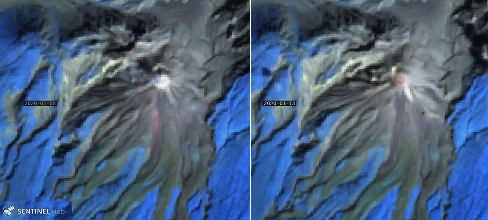 |
Figure 106. Incandescence at the summit and in the block avalanches on the S flank of the Caliente cone at Santa María’s Santiaguito’s complex was visible in Sentinel-2 satellite imagery on 8 and 13 January 2020. Atmospheric penetration rendering images (bands 12, 11, 8A) courtesy of Sentinel Hub Playground. |
The Washington VAAC reported an ash plume visible in satellite imagery at 4.6 km altitude drifting W on 3 February 2020. INSIVUMEH reported constant steam degassing that rose to 2.9-3.0 km altitude and drifted SW. In addition, 1-3 weak to moderate explosions per hour produced ash plumes to 3.1-3.5 km altitude that drifted about 1 km SW. Small amounts of ashfall around the volcano’s perimeter was common. The ash plumes on 5 February drifted NE over Santa María de Jesús. On 8 February the ash plumes drifted E and SE over the communities of Calaguache, El Nuevo Palmar, and Las Marías. Block avalanches on the S and SE flanks of Caliente dome continued, creating small ash clouds on the flank. Incandescence continued frequently at the crater and was also observed on the S flank in satellite imagery (figure 107).
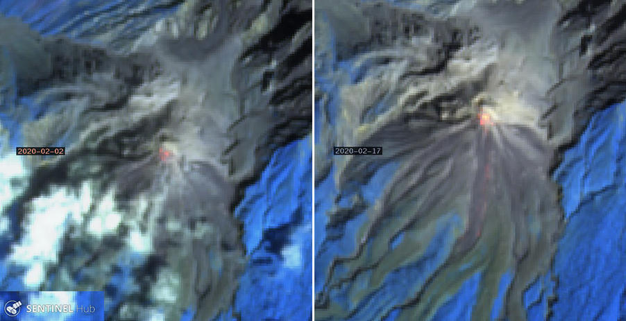 |
Figure 107. Incandescence at the summit and on the S flank of the Caliente cone at Santa María’s Santiaguito’s complex was frequent during February 2020, including on 2 (left) and 17 (right) February 2020 as seen in Sentinel-2 imagery. Atmostpheric Penetration rendering imagery (bands 12, 11, 8A) courtesy of Sentinel Hub Playground. |
Geological Summary. Symmetrical, forest-covered Santa María volcano is part of a chain of large stratovolcanoes that rise above the Pacific coastal plain of Guatemala. The sharp-topped, conical profile is cut on the SW flank by a 1.5-km-wide crater. The oval-shaped crater extends from just below the summit to the lower flank, and was formed during a catastrophic eruption in 1902. The renowned Plinian eruption of 1902 that devastated much of SW Guatemala followed a long repose period after construction of the large basaltic andesite stratovolcano. The massive dacitic Santiaguito lava-dome complex has been growing at the base of the 1902 crater since 1922. Compound dome growth at Santiaguito has occurred episodically from four vents, with activity progressing E towards the most recent, Caliente. Dome growth has been accompanied by almost continuous minor explosions, with periodic lava extrusion, larger explosions, pyroclastic flows, and lahars.
Information Contacts: Instituto Nacional de Sismologia, Vulcanologia, Meteorologia e Hydrologia (INSIVUMEH), Unit of Volcanology, Geologic Department of Investigation and Services, 7a Av. 14-57, Zona 13, Guatemala City, Guatemala (URL: http://www.insivumeh.gob.gt/ ); Washington Volcanic Ash Advisory Center (VAAC), Satellite Analysis Branch (SAB), NOAA/NESDIS OSPO, NOAA Science Center Room 401, 5200 Auth Rd, Camp Springs, MD 20746, USA (URL: www.ospo.noaa.gov/Products/atmosphere/vaac, archive at: http://www.ssd.noaa.gov/VAAC/archive.html); Sentinel Hub Playground (URL: https://www.sentinel-hub.com/explore/sentinel-playground); MIROVA (Middle InfraRed Observation of Volcanic Activity), a collaborative project between the Universities of Turin and Florence (Italy) supported by the Centre for Volcanic Risk of the Italian Civil Protection Department (URL: http://www.mirovaweb.it/).