Report on Fuego (Guatemala) — April 2020

Bulletin of the Global Volcanism Network, vol. 45, no. 4 (April 2020)
Managing Editor: Edward Venzke.
Edited by Kadie L. Bennis.
Fuego (Guatemala) Ongoing ash explosions, block avalanches, and intermittent lava flows
Please cite this report as:
Global Volcanism Program, 2020. Report on Fuego (Guatemala) (Bennis, K.L., and Venzke, E., eds.). Bulletin of the Global Volcanism Network, 45:4. Smithsonian Institution. https://doi.org/10.5479/si.GVP.BGVN202004-342090
Fuego
Guatemala
14.4748°N, 90.8806°W; summit elev. 3799 m
All times are local (unless otherwise noted)
Fuego is a stratovolcano in Guatemala that has been erupting since 2002 with historical eruptions that date back to 1531. Volcanism is characterized by major ashfalls, pyroclastic flows, lava flows, and lahars. The previous report (BGVN 44:10) detailed activity that included multiple ash explosions, ash plumes, ashfall, active lava flows, and block avalanches. This report covers this continuing activity from October 2019 through March 2020 and consists of ash plumes, ashfall, incandescent ejecta, block avalanches, and lava flows. The primary source of information comes from the Instituto Nacional de Sismologia, Vulcanología, Meteorología e Hidrologia (INSIVUMEH), the Washington Volcanic Ash Advisory Center (VAAC), and various satellite data.
Summary of activity October 2019-March 2020. Daily activity persisted throughout October 2019-March 2020 (table 20) with multiple ash explosions recorded every hour, ash plumes that rose to a maximum of 4.8 km altitude each month drifting in multiple directions, incandescent ejecta reaching a 500 m above the crater resulting in block avalanches traveling down multiple drainages, and ashfall affecting communities in multiple directions. The highest rate of explosions occurred on 7 November with up to 25 per hour. Dominantly white fumaroles occurred frequently throughout this reporting period, rising to a maximum altitude of 4.5 km and drifting in multiple directions. Intermittent lava flows that reached a maximum length of 1.2 km were observed each month in the Seca (Santa Teresa) and Ceniza drainages (figure 128), but rarely in the Trinidad drainage. Thermal activity increased slightly in frequency and strength in late October and remained relatively consistent through mid-March as seen in the MIROVA analysis of MODIS satellite data (figure 129).
Table 20. Activity summary by month for Fuego with information compiled from INSIVUMEH daily reports.
| Month | Ash plume heights (km) | Ash plume distance (km) and direction | Drainages affected by avalanche blocks | Villages reporting ashfall |
| Oct 2019 | 4.3-4.8 km | 10-25 km, W-SW-S-NW | Seca, Taniluyá, Ceniza, Trinidad, El Jute, Honda, and Las Lajas | Panimaché I and II, Morelia, Santa Sofía, Porvenir, Finca Palo Verde, La Rochela, San Andrés Osuna, Sangre de Cristo, and San Pedro Yepocapa |
| Nov 2019 | 4.0-4.8 km | 10-20 km, W-SW-S-NW | Seca, Taniluyá, Trinidad, Las Lajas, Honda, and Ceniza | Panimaché I and II, Morelia, Santa Sofía, Porvenir, Sangre de Cristo, Finca Palo Verde, and San Pedro Yepocapa |
| Dec 2019 | 4.2-4.8 km | 10-25 km, W-SW-S-SE-N-NE | Seca, Taniluya, Ceniza, Trinidad, and Las Lajas | Morelia, Santa Sofía, Finca Palo Verde, El Porvenir, Sangre de Cristo, San Pedro Yepocapa, Panimaché I and II, La Rochela, and San Andrés Osuna |
| Jan 2020 | 4.3-4.8 km | 10-25 km, W-SW-S-N-NE-E | Seca, Ceniza, Taniluyá, Trinidad, Honda, and Las Lajas | Morelia, Santa Sofía, Sangre de Cristo, San Pedro Yepocapa, Panimaché I and II, El Porvenir, Finca Palo Verde, Rodeo, La Rochela, Alotenango, El Zapote, Trinidad, La Reina, Ceilán |
| Feb 2020 | 4.3-4.8 km | 8-25 km, W-SW-S-SE-E-NE-N-NW | Seca, Ceniza, Taniluya, Trinidad, Las Lajas, Honda, La Rochela, El Zapote, and San Andrés Osuna | Panimache I and II, Morelia, Santa Sofia, Sangre de Cristo, San Pedro Yepocapa, Rodeo, La Reina, Alotenango, Yucales, Siquinalá, Santa Lucia, El Porvenir, Finca Los Tarros, La Soledad, Buena Vista, La Cruz, Pajales, San Miguel Dueñas, Ciudad Vieja, San Miguel Escobar, San Pedro las Huertas, Antigua, La Rochela, and San Andrés Osuna |
| Mar 2020 | 4.3-4.8 km | 10-23 km, W-SW-S-SE-N-NW | Seca, Ceniza, Trinidad, Taniluyá, Las Lajas, Honda, La Rochela, El Zapote, San Andrés Osuna, Morelia, Panimache, and Santa Sofia | San Andrés Osuna, La Rochela, El Rodeo, Chuchu, Panimache I and II, Santa Sofia, Morelia, Finca Palo Verde, El Porvenir, Sangre de Cristo, La Cruz, San Pedro Yepocapa, La Conchita, La Soledad, Alotenango, Aldea la Cruz, Acatenango, Ceilan, Taniluyá, Ceniza, Las Lajas, Trinidad, Seca, and Honda |
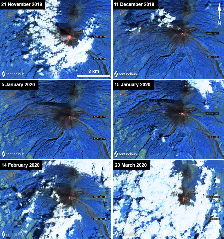 |
Figure 128. Sentinel-2 thermal satellite images of Fuego between 21 November 2019 and 20 March 2020 showing lava flows (bright yellow-orange) traveling generally S and W from the crater summit. An ash plume can also be seen on 21 November 2019, accompanying the lava flow. Sentinel-2 satellite images with “Atmospheric penetration” (bands 12, 11, 8A) rendering; courtesy of Sentinel Hub Playground. |
 |
Figure 129. Thermal activity at Fuego increased in frequency and strength (log radiative power) in late October 2019 and remained relatively consistent through February 2020. In early March, there is a small decrease in thermal power, followed by a short pulse of activity and another decline. Courtesy of MIROVA. |
Activity during October-December 2019. Activity in October 2019 consisted of 6-20 ash explosions per hour; ash plumes rose to 4.8 km altitude, drifting up to 25 km in multiple directions, resulting in ashfall in Panimaché I and II (8 km SW), Morelia (9 km SW), San Pedro Yepocapa (8 km NW), Sangre de Cristo (8 km WSW), Santa Sofía (12 km SW), El Porvenir (8 km ENE), Finca Palo Verde, La Rochela and San Andrés Osuna. The Washington VAAC issued multiple aviation advisories for a total of nine days in October. Continuous white gas-and-steam plumes reached 4.1-4.4 km altitude drifting generally W. Weak SO2 emissions were infrequently observed in satellite imagery during October and January 2020 (figure 130) Incandescent ejecta was frequently observed rising 200-400 m above the summit, which generated block avalanches that traveled down the Seca (W), Taniluyá (SW), Ceniza (SSW), Trinidad (S), El Jute, Honda, and Las Lajas (SE) drainages. During 3-7 October lahars descended the Ceniza, El Mineral, and Seca drainages, carrying tree branches, tree trunks, and blocks 1-3 m in diameter. During 6-8 and 13 October, active lava flows traveled up to 200 m down the Seca drainage.
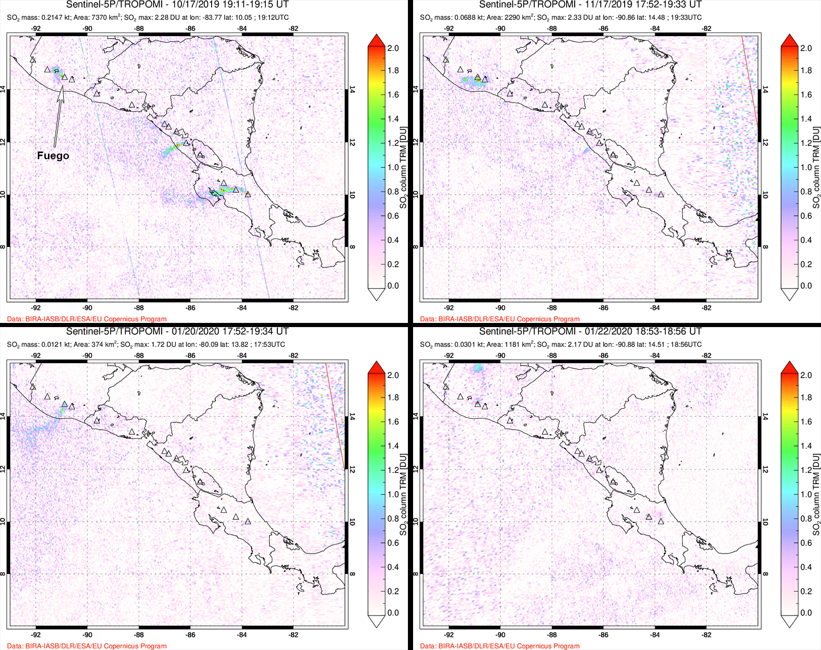 |
Figure 130. Weak SO2 emissions were observed rising from Fuego using the TROPOMI instrument on the Sentinel-5P satellite. Top left: 17 October 2019. Top right: 17 November 2019. Bottom left: 20 January 2020. Bottom right: 22 January 2020. Courtesy of NASA Global Sulfur Dioxide Monitoring Page. |
During November 2019, the rate of explosions increased to 5-25 per hour, the latter of which occurred on 7 November. The explosions resulted in ash plumes that rose 4-4.8 km altitude, drifting 10-20 km in the W direction. Ashfall was observed in Panimaché I and II, Morelia, Santa Sofía, Porvenir, Sangre de Cristo, Finca Palo Verde, and San Pedro Yepocapa. Multiple Washington VAAC notices were issued for 11 days in November. Continuous white gas-and-steam plumes rose up to 4.5 km altitude drifting generally W. Incandescent ejecta rose 100-500 m above the crater, generating block avalanches in Seca, Taniluyá, Trinidad, Las Lajas, Honda, and Ceniza drainages. Lava flows were observed for a majority of the month into early December measuring 100-900 m long in the Seca and Ceniza drainages.
The number of explosions in December 2019 decreased compared to November, recording 8-19 per hour with incandescent ejecta rising 100-400 m above the crater. The explosions generated block avalanches that traveled in the Seca, Taniluya, Ceniza, Trinidad, and Las Lajas drainages throughout the month. Ash plumes continued to rise above the summit crater to 4.8 km drifting up to 25 km in multiple directions. The Washington VAAC issued multiple daily notices almost daily in December. A continuous lava flow observed during 6-15, 21-22, 24, and 26 November through 9 December measured 100-800 m long in the Seca and Ceniza drainages.
Activity during January-March 2020. Incandescent Strombolian explosions continued daily during January 2020, ejecting material up to 100-500 m above the crater. Ash plumes continued to rise to a maximum altitude of 4.8 km, resulting in ashfall in all directions affecting Morelia, Santa Sofía, Sangre de Cristo, San Pedro Yepocapa, Panimaché I and II, El Porvenir, Finca Palo Verde, Rodeo, La Rochela, Alotenango, El Zapote, Trinidad, La Reina, and Ceilán. The Washington VAAC issued multiple notices for a total of 12 days during January. Block avalanches resulting from the Strombolian explosions traveled down the Seca, Ceniza, Taniluyá, Trinidad, Honda, and Las Lajas drainages. An active lava flow in the Ceniza drainage measured 150-600 m long during 6-10 January.
During February 2020, INSIVUMEH reported a range of 4-16 explosions per hour, accompanied by incandescent material that rose 100-500 m above the crater (figure 131). Block avalanches traveled in the Santa Teresa, Seca, Ceniza, Taniluya, Trinidad, Las Lajas, Honda, La Rochela, El Zapote, and San Andrés Osuna drainages. Ash emissions from the explosions continued to rise 4.8 km altitude, drifting in multiple directions as far as 25 km and resulting in ashfall in the communities of Panimache I and II, Morelia, Santa Sofia, Sangre de Cristo, San Pedro Yepocapa, Rodeo, La Reina, Alotenango, Yucales, Siquinalá, Santa Lucia, El Porvenir, Finca Los Tarros, La Soledad, Buena Vista, La Cruz, Pajales, San Miguel Dueñas, Ciudad Vieja, San Miguel Escobar, San Pedro las Huertas, Antigua, La Rochela, and San Andrés Osuna. Washington VAAC notices were issued almost daily during the month. Lava flows were active in the Ceniza drainage during 13-20, 23-24, and 26-27 February measuring as long as 1.2 km.
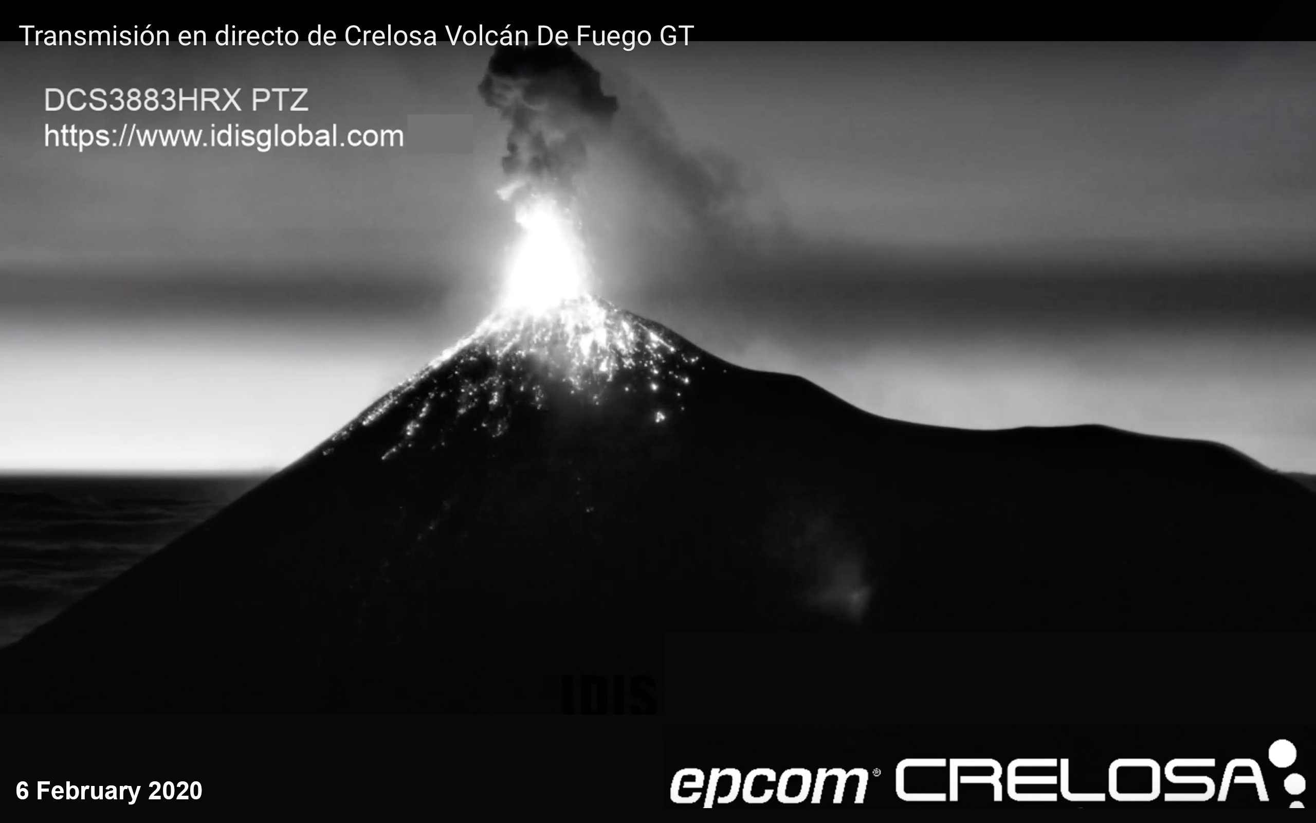 |
Figure 131. Incandescent ejecta rose several hundred meters above the crater of Fuego on 6 February 2020, resulting in block avalanches down multiple drainages. Courtesy of Crelosa. |
Daily explosions and incandescent ejecta continued through March 2020, with 8-17 explosions per hour that rose up to 500 m above the crater. Block avalanches from the explosions were observed in the Seca, Ceniza, Trinidad, Taniluyá, Las Lajas, Honda, Santa Teresa, La Rochela, El Zapote, San Andrés Osuna, Morelia, Panimache, and Santa Sofia drainages. Accompanying ash plumes rose 4.8 km altitude, drifting in multiple directions mostly to the W as far as 23 km and resulting in ashfall in San Andrés Osuna, La Rochela, El Rodeo, Chuchu, Panimache I and II, Santa Sofia, Morelia, Finca Palo Verde, El Porvenir, Sangre de Cristo, La Cruz, San Pedro Yepocapa, La Conchita, La Soledad, Alotenango, Aldea la Cruz, Acatenango, Ceilan, Taniluyá, Ceniza, Las Lajas, Trinidad, Seca, and Honda. Multiple Washington VAAC notices were issued for a total of 15 days during March. Active lava flows were observed from 16-21 March in the Trinidad and Ceniza drainages measuring 400-1,200 m long and were accompanied by weak to moderate explosions. By 23 March, active lava flows were no longer observed.
Geological Summary. Volcán Fuego, one of Central America's most active volcanoes, is also one of three large stratovolcanoes overlooking Guatemala's former capital, Antigua. The scarp of an older edifice, Meseta, lies between Fuego and Acatenango to the north. Construction of Meseta dates back to about 230,000 years and continued until the late Pleistocene or early Holocene. Collapse of Meseta may have produced the massive Escuintla debris-avalanche deposit, which extends about 50 km onto the Pacific coastal plain. Growth of the modern Fuego volcano followed, continuing the southward migration of volcanism that began at the mostly andesitic Acatenango. Eruptions at Fuego have become more mafic with time, and most historical activity has produced basaltic rocks. Frequent vigorous eruptions have been recorded since the onset of the Spanish era in 1524, and have produced major ashfalls, along with occasional pyroclastic flows and lava flows.
Information Contacts: Instituto Nacional de Sismologia, Vulcanologia, Meteorologia e Hydrologia (INSIVUMEH), Unit of Volcanology, Geologic Department of Investigation and Services, 7a Av. 14-57, Zona 13, Guatemala City, Guatemala (URL: http://www.insivumeh.gob.gt/); MIROVA (Middle InfraRed Observation of Volcanic Activity), a collaborative project between the Universities of Turin and Florence (Italy) supported by the Centre for Volcanic Risk of the Italian Civil Protection Department (URL: http://www.mirovaweb.it/); Sentinel Hub Playground (URL: https://www.sentinel-hub.com/explore/sentinel-playground); Global Sulfur Dioxide Monitoring Page, Atmospheric Chemistry and Dynamics Laboratory, NASA Goddard Space Flight Center (NASA/GSFC), 8800 Greenbelt Road, Goddard, Maryland, USA (URL: https://so2.gsfc.nasa.gov/); Washington Volcanic Ash Advisory Center (VAAC), Satellite Analysis Branch (SAB), NOAA/NESDIS OSPO, NOAA Science Center Room 401, 5200 Auth Rd, Camp Springs, MD 20746, USA (URL: www.ospo.noaa.gov/Products/atmosphere/vaac, archive at: http://www.ssd.noaa.gov/VAAC/archive.html); Crelosa, 3ra. avenida. 8-66, Zona 14. Colonia El Campo, Guatemala Ciudad de Guatemala (URL: http://crelosa.com/, post at https://www.youtube.com/watch?v=1P4kWqxU2m0&feature=youtu.be).