Report on Asosan (Japan) — July 2020
Bulletin of the Global Volcanism Network, vol. 45, no. 7 (July 2020)
Managing Editor: Edward Venzke.
Edited by A. Elizabeth Crafford.
Asosan (Japan) Daily ash emissions continue through mid-June 2020 when activity decreases
Please cite this report as:
Global Volcanism Program, 2020. Report on Asosan (Japan) (Crafford, A.E., and Venzke, E., eds.). Bulletin of the Global Volcanism Network, 45:7. Smithsonian Institution. https://doi.org/10.5479/si.GVP.BGVN202007-282110
Asosan
Japan
32.8849°N, 131.085°E; summit elev. 1592 m
All times are local (unless otherwise noted)
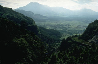
Japan's 24-km-wide Asosan caldera on the island of Kyushu has been active throughout the Holocene. Nakadake has been the most active of 17 central cones for 2,000 years; all historical activity is from Nakadake Crater 1. The largest ash plume in 20 years occurred on 8 October 2016. Asosan remained quiet until renewed activity from Crater 1 began in mid-April 2019; explosions with ash plumes continued through the first half of 2020 and are covered in this report. The Japan Meteorological Agency (JMA) provides monthly reports of activity; the Tokyo Volcanic Ash Advisory Center (VAAC) issues aviation alerts reporting on possible ash plumes, and Sentinel-2 satellite images provide data on ash emissions and thermal activity.
The Tokyo VAAC issued multiple daily reports of ash plumes from Nakadake Crater 1 from 1 January-14 June 2020. They were commonly at 1.8-2.1 km altitude, and often drifted E or S. JMA reported that ashfall continued downwind from the ash plumes until mid-June; seismic activity was relatively high during January and February and decreased steadily after that time. The measured SO2 emissions ranged from 1,000-4,900 tons per day through mid-June and dropped to 500 tons per day during the second half of June. Intermittent thermal activity was recorded at the crater through mid-May.
Explosive activity during January-June 2020. Ash plumes rose up to 1.1 km above the crater rim at Nakadake Crater 1 during January 2020 (figure 70). Ashfall was confirmed downwind of an explosion on 7 January. During February, ash plumes rose up to 1.7 km above the crater, and ashfall was again reported downwind. The crater camera provided by the Aso Volcano Museum occasionally observed incandescence at the floor of the crater during both months. Incandescence was also occasionally observed with the Kusasenri webcam (3 km W) and was seen on 20 February from a webcam in Minamiaso village (8 km SW).
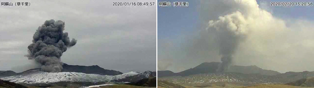 |
Figure 70. Ash plumes rose up to 1.1 km above the Nakadake Crater 1 at Asosan during January 2020 (left) and up to 1.7 km above the crater during February 2020 (right) as seen in these images from the Kusasenri webcam. Ashfall was reported downwind multiple times. Courtesy of JMA (Volcanic activity commentary material for Mt. Aso, January and February 2020). |
During March 2020, ash plumes rose as high as 1.3 km. Ashfall was reported on 9 March in Ichinomiyamachi, Aso City (figure 71). In field surveys conducted on the 18th and 25th, there was no visible water inside the crater, and high-temperature grayish-white plumes were observed. The temperature at the base of the plume was measured at 300°C (figure 72).
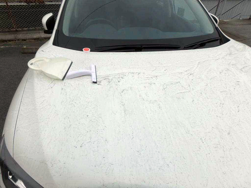 |
Figure 71. Ashfall from Asosan appeared on 9 March 2020 in Ichinomiyamachi, Aso City around 10 km N. Courtesy of JMA (Volcanic activity commentary material for Mt. Aso, March 2020). |
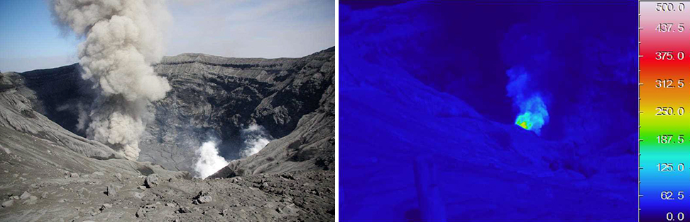 |
Figure 72. During a field survey of Nakadake Crater 1 at Asosan on 25 March 2020, JMA staff observed a gray ash plume rising from the crater floor (left). The maximum temperature of the ash plume was measured at about 300°C with an infrared thermal imaging device (right). Courtesy of JMA (Volcanic activity commentary material for Mt. Aso, March 2020). |
Occasional incandescence was observed at the bottom of the crater during April and May 2020; ash plumes rose 1.1 km above the crater on most days in April and were slightly higher, rising to 1.8 km during May, although activity was more intermittent (figure 73). A brief increase in SO2 activity was reported by JMA during field surveys on 7 and 8 May; satellite data captured small plumes of SO2 on 1 and 6 May (figure 74). A brief increase in tremor amplitude was reported by JMA on 16 May.
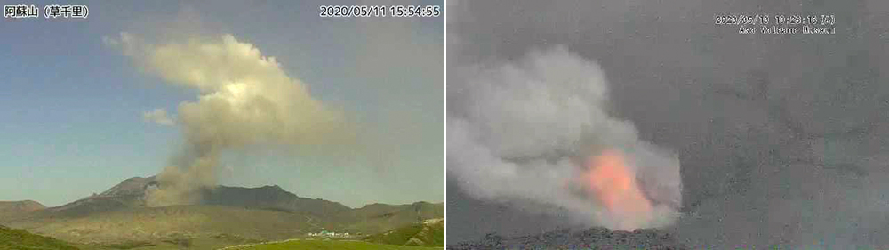 |
Figure 73. Although activity at Asosan’s Nakadake Crater 1 was more intermittent during April and May 2020 than earlier in the year, ash plumes were still reported most days and incandescence was seen at the bottom of the crater multiple times until 15 May. Left image taken 11 May 2020 from the Kusachiri webcam; right image taken from the crater webcam on 10 May provided by the Aso Volcano Museum. Courtesy of JMA (Volcanic activity commentary material for Mt. Aso, May 2020). |
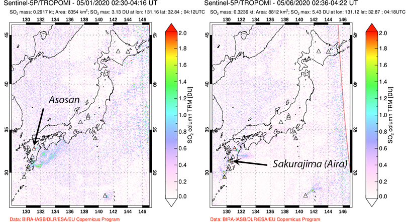 |
Figure 74. The TROPOMI instrument on the Sentinel-5P satellite detected small but distinct SO2 plumes from Asosan on 1 and 6 May 2020. Additional small plumes are visible from Aira caldera’s Sakurajima volcano. Courtesy of NASA’s Global Sulfur Dioxide Monitoring Page. |
The last report of ash emissions at Nakadake Crater 1 from the Tokyo VAAC was on 14 June 2020. JMA also reported that no eruption was observed after mid-June. On 8 June they reported an ash plume that rose 1.4 km above the crater. During a field survey on 16 June, only steam was observed at the crater; the plume rose about 100 m (figure 75). In addition, a small plume of steam rose from a fumarole on the S crater wall.
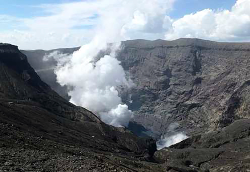 |
Figure 75. A steam plume rose about 100 m from the floor of Nakadake Crater 1 on 16 June 2020. A small steam plume was also observed by the S crater wall. Courtesy of JMA (Volcanic activity commentary material for Mt. Aso, June 2020). |
Thermal activity during January-June 2020. Sentinel-2 satellite data indicated thermal anomalies present at Nakadake Crater 1 on 2 January, 6 and 21 February, 16 April, and 11 May (figure 76). In addition, thermal anomalies from agricultural fires appeared in satellite images on 11 February, 7 and 17 March (figure 77). The fires were around 5 km from the crater, thus they appear on the MIROVA thermal anomaly graph in black, but are likely unrelated to volcanic activity (figure 78). No thermal anomalies were recorded in satellite data from the Nakadake Crater 1 after 11 May, and none appeared in the MIROVA data as well.
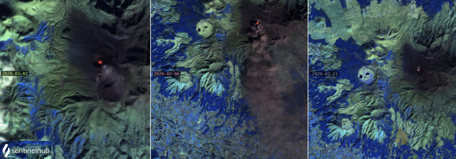 |
Figure 76. Thermal anomalies appeared at Asosan’s Nakadake Crater 1 on 2 January, 6 and 21 February, 16 April and 11 May 2020. On 2 January a small ash plume drifted SSE from the crater (left). On 6 February a dense ash plume drifted S from the crater (center). Only a small steam plume was visible above the crater on 21 February (right). Images use Atmospheric penetration rendering (bands 12, 11, 8A), courtesy of Sentinel Hub Playground. |
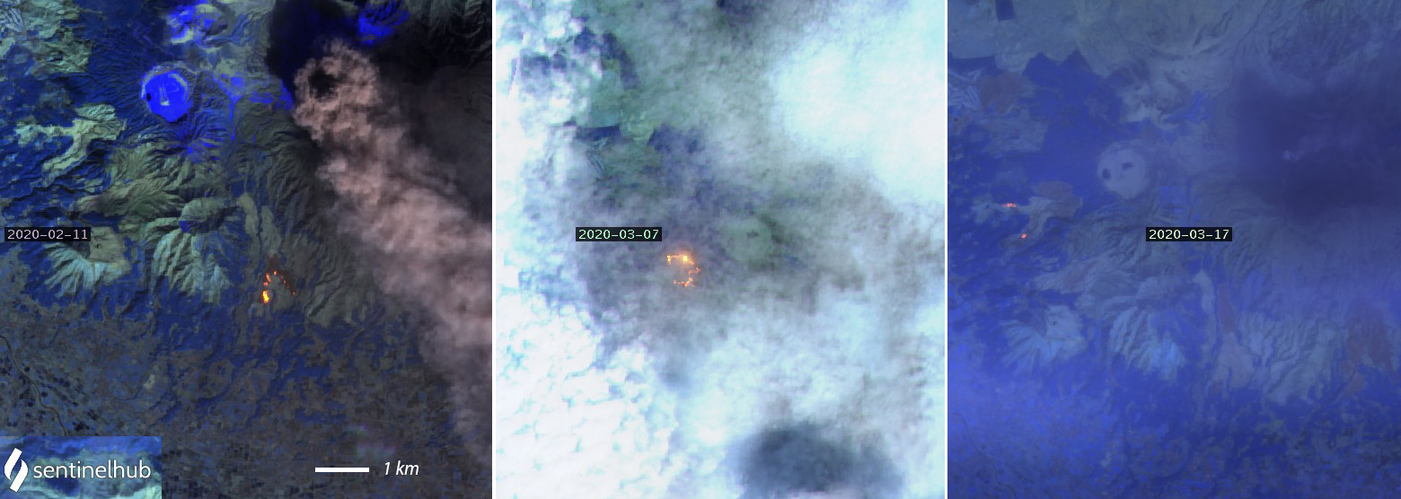 |
Figure 77. Thermal anomalies from agricultural fires located about 5 km from the crater appeared in satellite images on 11 February, and 7 and 17 March 2020. Although a dense ash plume drifted SSE from the crater on 11 February (left), no thermal anomalies appear at the crater on these dates. Images use Atmospheric penetration rendering (bands 12, 11, 8A), courtesy of Sentinel Hub Playground. |
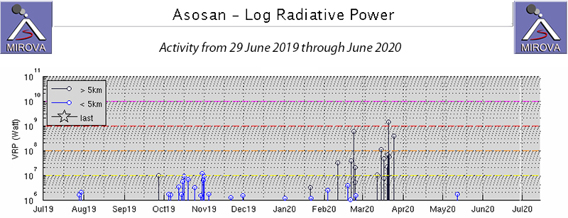 |
Figure 78. The MIROVA project plot of Log Radiative Power at Asosan from 29 June 2019 through June 2020 shows only a few small thermal alerts within 5 km of the summit crater during January-June 2020, and a spike in activity during February and March located around 5 km away. These data correlate well with the Sentinel-2 satellite data that show intermittent thermal anomalies at the summit throughout January-May and agricultural fires located several kilometers from the crater during February and March. Courtesy of MIROVA. |
Geological Summary. The 24-km-wide Asosan caldera was formed during four major explosive eruptions from 300,000 to 90,000 years ago. These produced voluminous pyroclastic flows that covered much of Kyushu. The last of these, the Aso-4 eruption, produced more than 600 km3 of airfall tephra and pyroclastic-flow deposits. A group of 17 central cones was constructed in the middle of the caldera, one of which, Nakadake, is one of Japan's most active volcanoes. It was the location of Japan's first documented historical eruption in 553 CE. The Nakadake complex has remained active throughout the Holocene. Several other cones have been active during the Holocene, including the Kometsuka scoria cone as recently as about 210 CE. Historical eruptions have largely consisted of basaltic to basaltic andesite ash emission with periodic strombolian and phreatomagmatic activity. The summit crater of Nakadake is accessible by toll road and cable car, and is one of Kyushu's most popular tourist destinations.
Information Contacts: Japan Meteorological Agency (JMA), 1-3-4 Otemachi, Chiyoda-ku, Tokyo 100-8122, Japan (URL: http://www.jma.go.jp/jma/indexe.html); Global Sulfur Dioxide Monitoring Page, Atmospheric Chemistry and Dynamics Laboratory, NASA Goddard Space Flight Center (NASA/GSFC), 8800 Greenbelt Road, Goddard, Maryland, USA (URL: https://so2.gsfc.nasa.gov/); MIROVA (Middle InfraRed Observation of Volcanic Activity), a collaborative project between the Universities of Turin and Florence (Italy) supported by the Centre for Volcanic Risk of the Italian Civil Protection Department (URL: http://www.mirovaweb.it/); Sentinel Hub Playground (URL: https://www.sentinel-hub.com/explore/sentinel-playground).