The Japan Meteorological Agency (JMA) reported that unrest at Asosan had decreased. The amplitude of volcanic tremors had increased during 4-7 July but then returned to low levels afterward. During field surveys on 16 and 23 July scientists observed no changes compared to field surveys conducted before the increased tremor amplitude. Sulfur dioxide gas emissions were low in July, averaging 200-500 tons per day. At 1100 on 25 July the Alert Level was lowered to 1 (on a scale of 1-5).
Source: Japan Meteorological Agency (JMA)
Ash explosions during 14-20 October 2021; plume to 3.5 km height and a pyroclastic flow
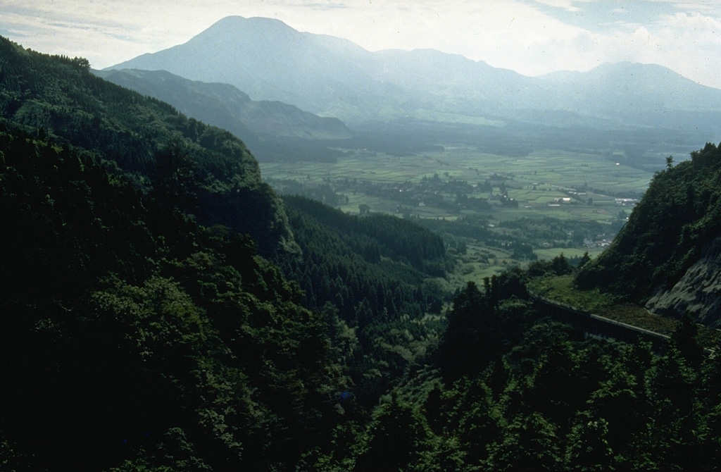
Asosan, on Japan’s southern island of Kyushu, is among the largest calderas in the world and one of Japan’s most active volcanoes. Among the group of 17 central cones, Nakadake is currently the most active. During April 2019, Nakadake entered an eruptive period, with ash explosions and emissions, elevated sulfur dioxide (SO2) levels, and intermittent thermal activity and incandescence. Elevated activity continued until 14 June 2020, after which the volcano entered a quiet stage with only gas emissions (BGVN 45:01, 45:07). The volcano is monitored by the Japan Meteorological Agency (JMA) and by satellites. This report discusses activity between 1 July 2020 and 31 December 2021.
Based on JMA reports, no explosions were recorded after mid-June 2020 until 14 October 2021. The only observed activity was white plumes that rose as high as 1 km above the crater. SO2 emissions decreased, and volcanic-tremor amplitude decreased to low levels on 18 July. During a field inspection on 17 August 2020 there was no water in the crater. Volcanic tremor amplitude increased on 2 May 2021 at 2100. SO2 emissions were low, at 200 metric tons/day on 3 May, and white steam plumes rose as high as 300 m above the crater rim. The amplitude remained high through 10 May and then gradually decreased.
JMA reported that tremor signals resumed on 12 October 2021; amplitude began increasing at 1530 on 13 October. White plumes rose 1.4 km above Nakadake Crater. On 14 October an explosion was detected at 0443; weather clouds prevented visual confirmation of a plume, though ejected incandescent material was visible in thermal camera images. During a field visit later that day, scientists confirmed ashfall in several areas, including parts of Takamori Town (7 km SSW of Nakadake crater), Taketa City (29 km ENE), and Takachiho Town (28 km SE). Weak explosions occurred on 15 October at 1057 and 1325. Volcanic tremor amplitude increased at 1400 on 18 October. During an overflight, scientists observed ash deposits extending SE from Nakadake Crater. Volcanic tremor amplitude continued to fluctuate at high levels on 19 October.
At 1143 on 20 October an explosion ejected blocks 900 m S and produced an ash plume that rose 3.5 km above the crater rim and drifted E (figures 79-81). Pyroclastic flows descended 1.3 km W. Very small explosions were recorded during 1244-1410. One news source (The Japan Times) stated that all 16 climbers on the volcano at the time of the explosion returned safely. That same source reported that on the following day, a street-sweeping truck in Takamori began to clear several dozen tons of ash. On 21 October, the SO2 emission rate was high at 2,500 metric tons/day (t/d), but lower than the rate during the previous day of 4,400 t/d. During 21-22 October, white plumes rose 900 m from the crater.
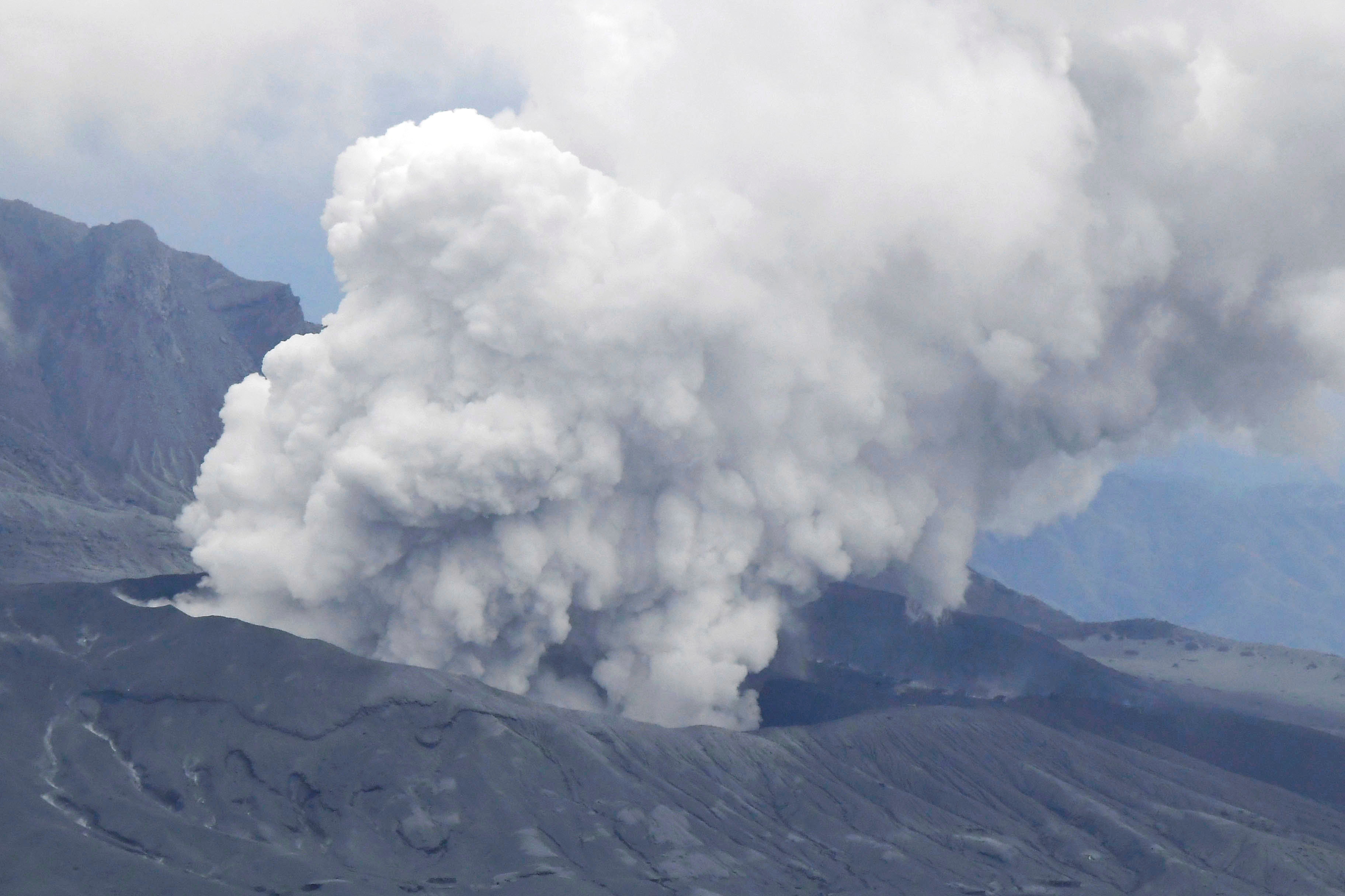 |
Figure 79. Aerial view of that explosion at Asosan on 20 October 2021. Courtesy of Kyodo News. |
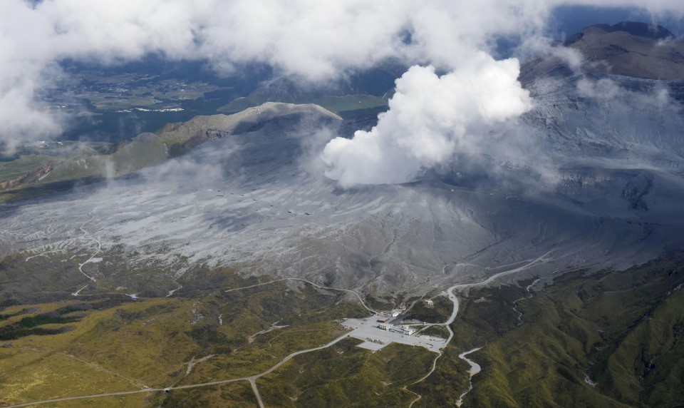 |
Figure 80. Photo of the 20 October 2021 explosion at Asosan taken from a helicopter. The Aso Volcano Museum is at the bottom of the image. Courtesy of Kyodo News. |
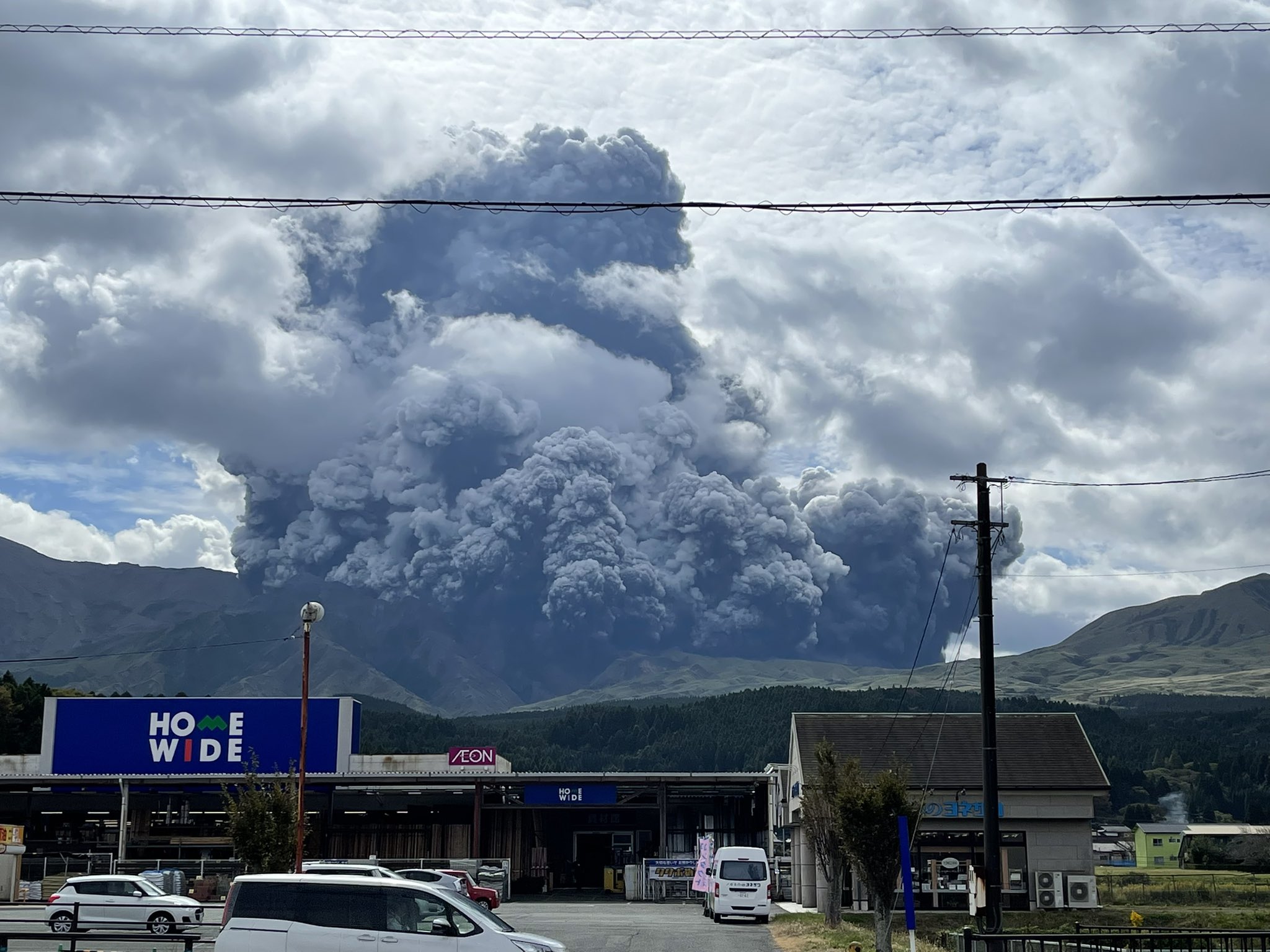 |
Figure 81. Ash explosion at Asosan on 20 October 2021. Photo by @NINJA250_NBYK. |
On 18 November JMA lowered the Alert Level to 2 and decreased the restricted area to a radius of 1 km, noting that no explosions had been recorded since 20 October. The amplitudes of volcanic microtremors fluctuated for a period after the explosion, though they were generally small beginning on 1 November. A field survey by JMA on 16 November had found that the SO2 emission was still high at 2,100 t/d, and it remained elevated through the end of the year. No further explosions were recorded through the end of the year.
Information Contacts: Japan Meteorological Agency (JMA), 1-3-4 Otemachi, Chiyoda-ku, Tokyo 100-8122, Japan (URL: http://www.jma.go.jp/jma/indexe.html); Kyodo News (URL: https://english.kyodonews.net/); The Japan Times (URL: https://www.japantimes.co.jp/); Twitter User @NINJA250_NBYK (URL: https://twitter.com/NINJA250_NBYK).
2025: July
2024: May
2023: January
| March
2022: February
| March
| April
2021: April
| June
| October
| November
2020: January
| February
| March
| April
| May
| August
2019: April
| May
| July
| August
| September
| October
| November
| December
2016: March
| April
| October
2015: January
| February
| March
| April
| September
| October
| November
2014: January
| February
| August
| September
| October
| November
| December
2011: May
| June
2005: April
2004: January
2003: July
2002: August
The Japan Meteorological Agency (JMA) reported that unrest at Asosan had decreased. The amplitude of volcanic tremors had increased during 4-7 July but then returned to low levels afterward. During field surveys on 16 and 23 July scientists observed no changes compared to field surveys conducted before the increased tremor amplitude. Sulfur dioxide gas emissions were low in July, averaging 200-500 tons per day. At 1100 on 25 July the Alert Level was lowered to 1 (on a scale of 1-5).
Source: Japan Meteorological Agency (JMA)
The Japan Meteorological Agency (JMA) reported that the amplitude of volcanic tremors at Asosan began to increase at around 1150 on 4 July, signaling an increasing unrest. Sulfur dioxide gas emissions were low, averaging 300-600 tons per day. White plumes rose 300 m above the crater rim. At 1300 the Alert Level was raised to 2 (on a scale of 1-5) and the public was warned to stay at least 1 km away from Nakadake Crater.
Source: Japan Meteorological Agency (JMA)
JMA reported continuing unrest at Asosan. Sulfur dioxide gas emissions were somewhat high, averaging 1,600 tons per day (t/d), when measured during a field survey on 9 May. The amplitude of volcanic tremors began to increase at around 0600 on 15 May and increased again round 0900. At 0920 the Alert Level was raised to 2 (on a scale of 1-5) and the public was warned to stay at least 1 km away from the crater. During a field visit later that morning scientists observed a hot spring within the pool on the Nakadake Crater floor and measured sulfur dioxide emissions of 800 t/d. Volcanic tremor amplitude was variable and decreased to low levels by 0700 on 16 May. White steam-and-gas plumes rose 100-300 m above the crater rim during 16-17 May and crater incandescence was occasionally visible in webcam images at night. Sulfur dioxide emissions had decreased to 500 t/d on 17 May.
Source: Japan Meteorological Agency (JMA)
The amplitude of volcanic tremor signals at Asosan increased in December 2022, and then further intensified on 30 January, prompting JMA to raise the Alert Level to 2 (on a scale of 1-5) and warn the public to stay at least 1 km away from the crater. The amplitude fluctuated at high levels for a few weeks, and then decreased on 19 February and again on 14 March. Daily sulfur dioxide emissions had exceeded 1,000 tons per day starting in December 2022; emissions declined to below that threshold by mid-January and remained at lower levels. At 1100 on 23 March the Alert Level was lowered to 1.
Source: Japan Meteorological Agency (JMA)
JMA reported that the amplitude of volcanic tremor signals at Asosan increased at around 1200 on 30 January and then increased again around 1220 and remained high. At 1330 JMA raised the Alert Level to 2 (on a scale of 1-5) and warned the public to stay at least 1 km away from the crater. White plumes were visible rising 300 m above the crater rim.
Source: Japan Meteorological Agency (JMA)
JMA reported that no eruptions had been recorded at Asosan after the end of the last eruption in October 2021. Crater incandescence, which had been occasionally visible since December 2021, was absent beginning on 27 February. Deflation began around 27 February but stabilized in April. Observations of the crater from 17 March revealed that it had deepened, compared to pre-eruption conditions, and that water had returned. Sulfur dioxide emissions had increased to 1,600 tons per day on 25 March, but four observations made during 29 March-12 April showed values in the range of 800-1,200 tons per day. Though these values were higher than those measured in September 2021, before the eruption, they represented a decreasing trend. During a field visit on 7 April scientists observed white emissions rising from Nakadake Crater and gray pools of hot water on the crater floor. A hot spring was active on the S side of the pools. The area of the water represented about 40 percent of the crater floor and the water temperature was 71 degrees Celsius. JMA lowered the Alert Level to 1 (on a scale of 1-5) on 15 April, noting that the likelihood of an eruption affecting an area within a radius of 1 km had decreased.
Source: Japan Meteorological Agency (JMA)
JMA reported that the amplitude of volcanic tremor signals at Asosan had decreased at around 1540 on 27 February and remained low. White plumes rose 600-800 m above the crater during 7-14 March. During field surveys conducted on 8 and 10 March sulfur dioxide gas emissions were 1,300 and 900 tons per day, respectively; these values were higher than those measured before the October 2021 eruption. No other changes were observed. JMA lowered the Alert Level to 2 (on a scale of 1-5) on 14 March and warned the public to stay at least 1 km away from the crater.
Source: Japan Meteorological Agency (JMA)
JMA reported that the amplitude of volcanic tremor signals at Asosan increased at around 0500 on 24 February and then increased again around 0900. About 45 minutes later JMA raised the Alert Level to 3 (on a scale of 1-5) and warned the public to stay at least 2 km away from the crater. Tremor amplitude decreased at around 1540 on 27 February. White plumes continued to rise 700-800 m above the crater rim during 24-28 February.
Source: Japan Meteorological Agency (JMA)
JMA lowered the Alert Level for Asosan to 2 (on a scale of 1-5) at 1100 on 18 November and decreased the restricted area to a radius of 1 km, noting that no eruptions had been recorded since the 21 October eruption. The sulfur dioxide emission rate remained elevated in November and was 2,100 tons per day on 16 November. The amplitudes of volcanic microtremors fluctuated for a period after the eruption, though they were generally small beginning on 1 November.
Source: Japan Meteorological Agency (JMA)
JMA characterized the eruption at Asosan that occurred at 1143 on 20 October as medium-sized. The event ejected blocks 900 m S, produced pyroclastic flows that descended 1.3 km W, and generated an ash plume that rose 3.5 km above the crater rim. Very small eruptive events were recorded during 1244-1410. The sulfur dioxide emission rate was high at 2,500 tons per day on 21 October. White plumes rose 900 m from the crater during 21-22 October. The Alert Level remained at 3 (on a scale of 1-5).
Source: Japan Meteorological Agency (JMA)
According to JMA the number of volcanic tremor signals at Asosan began on 12 October. Tremor amplitude began increasing at 1530 on 13 October, prompting JMA to raise the Alert Level to 2 (on a scale of 1-5) almost two hours later. White plumes rose 1.4 km above Nakadake Crater. An eruption was detected at 0443 on 14 October; weather clouds prevented visual confirmation of an eruption plume, though ejected incandescent material was visible in thermal camera images. During a field visit to the volcano later that day, scientists confirmed ashfall in several areas, including parts of Takamori Town (Kumamoto Prefecture), Taketa City (Oita Prefecture), and Takachiho Town (Miyazaki Prefecture). Small eruptive events occurred at 1057 and 1325 on 15 October. Volcanic tremor amplitude increased at 1400 on 18 October. During an overflight scientists observed ash deposits extending SE from Nakadake Crater. Volcanic tremor amplitude continued to fluctuate at high levels on 19 October. At 1143 on 20 October a notable eruption ejected blocks 900 m S and produced an ash plume that rose 3.5 km above the crater rim and drifted E. Pyroclastic flows descended 1.3 km W. The Alert Level was raised to 3 at 1148 and warned the public to stay 2 km away from Nakadake Crater.
Source: Japan Meteorological Agency (JMA)
Volcanic tremor amplitude had increased at Asoson on 2 May, prompting JMA to raise the Alert Level to 2 (on a scale of 1-5). The amplitude remained high through 10 May, and then gradually decreased. On 9 June the Alert Level was lowered to 1 and the public was warned of an increased risk within 1 km of Nakadake Crater.
Source: Japan Meteorological Agency (JMA)
Volcanic tremor amplitude increased at Asoson at around 2100 on 2 May, prompting JMA to raise the Alert Level to 2 (on a scale of 1-5) at 2255. The public was warned to stay at least 1 km away from the crater. Sulfur dioxide emissions were low, at 200 tons per day on 3 May, and white steam plumes rose as high as 300 m above the crater rim.
Source: Japan Meteorological Agency (JMA)
JMA reported that no eruptions at Asosan had been observed since 16 June; only white plumes rose as high as 1 km above the crater afterwards. Sulfur dioxide emissions had been low since mid-June, and volcanic-tremor amplitude decreased to low levels on 18 July. During a field inspection on 17 August, observers noted no water in the crater and a whitish area at the center of the crater floor. On 18 August the Alert Level was lowered to 1 (on a scale of 1-5).
Source: Japan Meteorological Agency (JMA)
JMA reported that eruptive activity at Asosan was recorded during 29 May-2 June. Volcanic plumes rose 1,000-1,600 m above the crater rim. The sulfur dioxide emission rate was high; the rate was 1,000 tons per day on 27 May. The Alert Level remained at 2 (on a scale of 1-5).
Source: Japan Meteorological Agency (JMA)
JMA reported that eruptive activity at Asosan was recorded during 11-18 May. Volcanic plumes rose 600-1,000 m above the crater rim and caused ashfall in areas downwind. The sulfur dioxide emission rate was high; the rate was 1,300 tons per day on 17 May. The Alert Level remained at 2 (on a scale of 1-5).
Source: Japan Meteorological Agency (JMA)
JMA reported that eruptive activity at Asosan was recorded during 4-11 May. Volcanic plumes rose 700-900 m above the crater rim and caused ashfall in areas downwind. The sulfur dioxide emission rate was high at 3,000-4,800 tons per day during 7-8 May. The Alert Level remained at 2 (on a scale of 1-5).
Source: Japan Meteorological Agency (JMA)
JMA reported that eruptive activity at Asosan was recorded during 13-20 April. Gray-white ash plumes rose 800-1,100 m above the crater rim and caused ashfall in areas downwind. The sulfur dioxide emission rate was somewhat high at 1,600 and 1,200 tons per day on 14 and 16 April, respectively. The Alert Level remained at 2 (on a scale of 1-5).
Source: Japan Meteorological Agency (JMA)
JMA reported that eruptive activity at Asosan was recorded during 9-16 March. Gray-to-white ash plumes rose as high as 1 km above the crater rim and caused ashfall in areas downwind. The sulfur dioxide emission rate was high; the rate on 2 April was 1,900 tons per day. The Alert Level remained at 2 (on a scale of 1-5).
Source: Japan Meteorological Agency (JMA)
JMA reported that eruptive activity at Asosan was recorded during 9-16 March. Gray-to-white ash plumes rose 600-800 m above the crater rim and caused ashfall in areas downwind. The sulfur dioxide emission rate was high at 1,600-1,700 tons per day on 11 and 16 March. The Alert Level remained at 2 (on a scale of 1-5).
Source: Japan Meteorological Agency (JMA)
JMA reported that eruptive activity at Asosan was recorded during 25 February-2 March. Gray-to-white ash plumes rose 700 m above the crater rim and caused ashfall in areas downwind. The sulfur dioxide emission rate was high, ranging from 1,500 to 4,900 tons per day. The Alert Level remained at 2 (on a scale of 1-5).
Source: Japan Meteorological Agency (JMA)
JMA reported that eruptive activity at Asosan was recorded during 10-17 February. Ash plumes rose 900-1,300 m above the crater rim and caused ashfall in areas downwind. The sulfur dioxide emission rate continued to be at a high level. The Alert Level remained at 2 (on a scale of 1-5).
Source: Japan Meteorological Agency (JMA)
JMA reported that eruptive activity at Asosan was recorded during 27 January-3 February. Plumes rose 1.1 km above the crater rim and caused ashfall in areas downwind. The sulfur dioxide emission rate was high, ranging from 1,900 to 3,400 tons per day during 28-29 and 31 January and 3 February. The Alert Level remained at 2 (on a scale of 1-5).
Sources: Japan Meteorological Agency (JMA); Tokyo Volcanic Ash Advisory Center (VAAC)
JMA reported that eruptive activity at Asosan was recorded during 7-20 January. Plumes rose 0.9-1 km above the crater rim during 15-20 January and caused ashfall in areas downwind; the Tokyo VAAC reported that ash plumes mainly drifted S, SE, E, and NE. The Alert Level remained at 2 (on a scale of 1-5).
Sources: Japan Meteorological Agency (JMA); Tokyo Volcanic Ash Advisory Center (VAAC)
JMA reported that the eruption at Asosan that began on 7 October continued through 16 December. Ash plumes rose as high as 1 km and caused ashfall in areas downwind. The sulfur dioxide emission rate was 3,000-3,300 tons per day on 11 and 16 September. The Alert Level remained at 2 (on a scale of 1-5).
Source: Japan Meteorological Agency (JMA)
JMA reported that the eruption at Asosan that began on 7 October continued through 18 November. The Tokyo VAAC reported that during 13-18 November ash plumes rose to 1.5-2.4 km (5,000-8,000 ft) a.s.l. and drifted in multiple directions. On 18 November JMA confirmed ashfall in downwind areas.
Source: Japan Meteorological Agency (JMA)
JMA reported that during 7-15 October ash plumes rose as high as 1.3 km above Asosan’s summit crater rim, causing ashfall in areas downwind including periodically at the Kumamoto Regional Meteorological Observatory. Crater incandescence was occasionally visible at night. The sulfur dioxide emission rate was very high at 4,000 tons per day on 11 October. The Alert Level remained at 2 (on a scale of 1-5).
Source: Japan Meteorological Agency (JMA)
JMA reported that during 2-7 October ash plumes rose as high as 1.2 km above Asosan’s summit crater rim and drifted NE and NW, causing ashfall in areas downwind including Aso City. Crater incandescence was occasionally visible at night. The sulfur dioxide emission rate was 2,800 tons per day on 7 October. The Alert Level remained at 2 (on a scale of 1-5).
Source: Japan Meteorological Agency (JMA)
JMA reported that during 25-30 September ash plumes rose as high as 1.6 km above Asosan’s summit crater rim and drifted NE and NW, causing ashfall in areas downwind. The sulfur dioxide emission rate was 2,600 tons per day on 26 September. The Alert Level remained at 2 (on a scale of 1-5).
Source: Japan Meteorological Agency (JMA)
JMA reported that ash emissions continued to be observed at Asosan, rising to 1.6, 1.1, and 0.9 km above the crater rim during 14-17, 18-20, and 21-24 September, respectively. Sulfur dioxide emissions were high at 3,600 tons per day on 17 September and 2,700 tons per day on 19 September. Ashfall was reported in downwind areas to the SW, including at the Kumamoto Regional Meteorological Observatory. The Alert Level remained at 2 (on a scale of 1-5).
Source: Japan Meteorological Agency (JMA)
JMA reported that during 10-13 September ash plumes rose 1.6 km above Asosan’s summit crater rim. The sulfur dioxide emission rate was 1,600 tons per day on 11 September. The Alert Level remained at 2 (on a scale of 1-5).
Source: Japan Meteorological Agency (JMA)
JMA reported that during 2-9 September ash plumes rose from Asosan and drifted N and NW. The sulfur dioxide emission rate was 800, 2,500, and 2,000 tons per day on 2, 6, and 9 September, respectively. The Alert Level remained at 2 (on a scale of 1-5).
Source: Japan Meteorological Agency (JMA)
JMA and the Tokyo VAAC reported that an eruptive event at Asosan was recorded at 1929 on 29 August; a plume rose 200 m above the crater rim and drifted N. During 30 August-3 September ash plumes rose as high as 250 m and drifted E, NE, N, and NW. The Alert Level remained at 2 (on a scale of 1-5).
Sources: Japan Meteorological Agency (JMA); Tokyo Volcanic Ash Advisory Center (VAAC)
JMA reported that during 18-23 August ash plumes rose from Asosan and drifted N and NW. Crater incandescence was visible at night. An eruption recorded during 1130-1945 on 25 August generated ash plumes that drifted E. The sulfur dioxide emission rate was 1,800 tons per day on 21 August and remained high on 25 August. The Alert Level remained at 2 (on a scale of 1-5).
Source: Japan Meteorological Agency (JMA)
JMA reported that increased eruptive activity at Asosan that began on 28 July paused at 1110 on 16 August. An eruptive event was recorded at 1627 on 18 August; elevated eruptive activity continued at least through 19 August. The Tokyo VAAC reported that the eruptive event on 18 August produced an ash plume that rose to 2.1 km (7,000 ft) a.s.l. Ash plumes rose to 1.5-2.1 km (5,000-7,000 ft) a.s.l. and drifted N and NW during 19-20 August. The Alert Level remained at 2 (on a scale of 1-5).
Source: Japan Meteorological Agency (JMA)
JMA reported that increased eruptive activity at Asosan that began on 28 July continued at least through 13 August. Ash plumes drifted N and NW, and crater incandescence was visible at night. Sulfur dioxide gas emissions were very high at 2,000-5,000 tons per day. The Alert Level remained at 2 (on a scale of 1-5).
Source: Japan Meteorological Agency (JMA)
JMA reported that increased eruptive activity at Asosan that began on 28 July continued at least through 5 August. Volcanologists confirmed that high-temperature, gray-white plumes rose from the center of Nakadake Crater during fieldwork conducted on 31 July. Grayish white plumes rose 1.3 km and 1.5 km above the crater rim on 1 and 5 August, respectively. Incandescence from the crater was visible at night. The Alert Level remained at 2 (on a scale of 1-5).
Source: Japan Meteorological Agency (JMA)
JMA reported that at 0757 on 26 July a small eruption at Asosan’s Nakadake Crater generated grayish-white ash plumes that rose 1.6 km above the crater rim and drifted NW. Webcam images showed incandescent material in the vent. Minor ashfall was reported in areas downwind including Minamioguni-cho (Kumamoto Prefecture, N) and Kuze-cho (Oita Prefecture, NE). Plumes continued to be emitted during 0900-1300, rising to 400 m. Activity increased at 0442 on 28 July and remained elevated at least through 1500 on 29 July. Grayish-white plumes rose as high as 1.2 km above the crater rim and drifted NE and N. Sulfur dioxide emissions were very high on 29 July, at 4,300 tons per day. The Alert Level remained at 2 (on a scale of 1-5).
Source: Japan Meteorological Agency (JMA)
JMA reported that sulfur dioxide emissions at Asosan’s Nakadake Crater reached a high value of 2,300 tons per day on 12 July. Very small events ejected sediment during 13-16 July. The Alert Level remained at 2 (on a scale of 1-5).
Source: Japan Meteorological Agency (JMA)
JMA reported that minor explosive events on 4 and 5 July at Asosan’s Nakadake Crater ejected sediment from the vent. Sulfur dioxide emissions were 1,300 tons per day on 5 July. The Alert Level remained at 2 (on a scale of 1-5).
Source: Japan Meteorological Agency (JMA)
JMA reported that very small eruptive events at Asosan’s Nakadake Crater on 29 and 31 May generated plumes that rose 400 m above the crater rim and, according to the Tokyo VAAC, drifted S and N, respectively. Sulfur dioxide emissions continued to be high at 2,000 tons per day. The Alert Level remained at 2 (on a scale of 1-5).
Sources: Japan Meteorological Agency (JMA); Tokyo Volcanic Ash Advisory Center (VAAC)
JMA reported that during 15-20 May sulfur dioxide emission levels were somewhat high at Asosan’s Nakadake Crater. At 1028 on 15 May an eruption produced a plume that rose 700 m above the crater rim. White plumes rose 200 m during 17-20 May. The Alert Level remained at 2 (on a scale of 1-5).
Source: Japan Meteorological Agency (JMA)
JMA reported that incandescence from Asosan’s Nakadake Crater was visible during 9-10 May. A small eruption on 9 May produced a plume that rose 900 m above the crater rim. Four small eruptions on 12 May generated plumes that rose to a maximum height of 1.4 km. A plume from an eruption on 13 May rose 200 m. Sulfur dioxide emissions were 3,600 tons per day on 10 May, and 1,700 tons per day on 13 May. The Alert Level remained at 2 (on a scale of 1-5).
Source: Japan Meteorological Agency (JMA)
JMA reported that sulfur dioxide emissions at Asosan’s Nakadake Crater continued to be very high at 3,200 tons per day on 2 May. At night during 2-3 May webcams recorded weak incandescence from the crater. At 1540 on 3 May a very small eruption produced an off-white plume that rose 600 m above the crater rim. Later that day, at 1948, an ash plume rose 2 km and, according to the Tokyo VAAC, drifted S. Emissions from eruptive events continued until 0620 on 5 May, rising to 500 m. Afterwards white plumes rose as high as 1.1 km, at least through 7 May. Crater incandescence continued to be visible.
During a field survey on 4 May ashfall was confirmed in areas downwind including parts of Takamori (7 km SSE), Minamiaso village (8 km SW), and Yamato (24 km SSW). Sulfur dioxide emissions were 4,000 tons per day on 4 May, and 3,100 tons per day on 6 May. The Alert Level remained at 2 (on a scale of 1-5).
Sources: Japan Meteorological Agency (JMA); Tokyo Volcanic Ash Advisory Center (VAAC)
JMA reported that during 24-29 April white plumes from Asosan’s Nakadake Crater rose 200-800 m above the crater rim. Many low-amplitude tremors and volcanic earthquakes were recorded. Sulfur dioxide emissions were generally high but on 25 April the gas emissions were very high at 4,000 tons/day, a value not exceeded since 12 March. Emissions were 3,300 tons/day on 25 April. Weak incandescence from Nakadake Crater was visible at night during 27-28 April. The Alert Level remained at 2 (on a scale of 1-5).
Source: Japan Meteorological Agency (JMA)
JMA reported that during 17-19 April white plumes from Asosan’s Nakadake Crater rose 1 km above the crater rim. A very small eruption was recorded at 0824 on 19 April, producing a plume that rose 500 m above the crater rim and drifted S. During an overflight that same day scientists observed a pool of hot water on part of the crater floor and a weak volcanic gas odor. According to the Tokyo VAAC a plume rose 500 m and drifted E at 1842. A weak volcanic gas odor was also evident. The Alert Level remained at 2 (on a scale of 1-5).
Sources: Japan Meteorological Agency (JMA); Tokyo Volcanic Ash Advisory Center (VAAC)
JMA reported an increase in the amplitude of volcanic tremor at Asosan on 14 April, increasing the possibility of an eruption at Nakadake Crater. The Alert Level was raised to 2 (on a scale of 1-5). Tremor amplitude further increased on 15 April. A very small eruption was recorded at 1828 on 16 April, producing a plume that rose 200 m above the crater rim and drifted NW.
Source: Japan Meteorological Agency (JMA)
JMA reported that no further explosions were detected after the 7-8 October eruption at Asosan’s Nakadake Crater; white plumes rose as high as 400 m above the crater rim during 11-17 October. The Alert Level remained at 3 (on a scale of 1-5).
Source: Japan Meteorological Agency (JMA)
JMA reported that explosive eruptions at Asosan’s Nakadake Crater occurred at 2152 on 7 October and 0146 on 8 October, after a period of deformation was detected. Inclement weather prevented visual observations, although satellite images showed the 8 October ash plume rising to an altitude of 11 km (36,100 ft) a.s.l. The Alert Level was raised to 3 (on a scale of 1-5). During an overflight scientists observed high temperatures in the crater, and white plumes rising 300 m above the rim. Ash deposits extended as far as 1.6 km on the NW flank and 1 km on the SE flank, and were abundant on the NE flank. Ashfall 3 cm thick was reported at the Aso police station 6 km NE. According to news articles, ashfall was reported as far away as 320 km, and some farmers 6-8 km away reported damage to their greenhouses, and a window was cracked from tephra at a youth center 5 km away. Samples analyzed by The National Institute of Advanced Industrial Science and Technology (AIST) and the National Research Institute for Earth Science and Disaster Prevention (NIED) revealed a 10% juvenile magma component, and that the explosions were possibly phreatomagmatic.
Sources: Japan Meteorological Agency (JMA); Reuters
JMA reported that field surveys at Asosan’s Nakadake Crater on 20 April confirmed an eruption that had been detected on 16 April. Scientists observed deposits from a phreatic explosion at a vent in the S crater which contains a crater lake. The Alert Level remained at 2 (on a scale of 1-5).
Source: Japan Meteorological Agency (JMA)
JMA reported that a very small eruption at Asosan’s Nakadake Crater was detected at 0830 on 16 April. A white plume rose 100 m above the crater rim. The Alert Level remained at 2 (on a scale of 1-5).
Source: Japan Meteorological Agency (JMA)
JMA reported that during 14-18 March white plumes rose as high as 300 m above Asosan’s Nakadake Crater. Seismicity was low. The Alert Level remained at 2 (on a scale of 1-5).
Source: Japan Meteorological Agency (JMA)
JMA reported that during 7-14 March white plumes rose as high as 600 m above Asosan’s Nakadake Crater. Seismicity was low. The Alert Level remained at 2 (on a scale of 1-5).
Source: Japan Meteorological Agency (JMA)
JMA reported that at 0656 on 4 March an explosion at Asosan’s Nakadake Crater generated a milky-white plume that rose 1 km above the crater rim; white plumes rose 300 m afterwards. The amplitude of volcanic tremor had increased around the time of the eruption, but then had decreased afterwards. Fieldwork confirmed that a small amount of sediment had been ejected from the crater's hot lake, and ash had fallen on the E side of Aso and in Takamori (10 km ESE). The Alert Level remained at 2 (on a scale of 1-5).
Source: Japan Meteorological Agency (JMA)
JMA reported that during 16-24 November white plumes rose 400-500 m above the rim of Asosan’s Nakadake Crater. The Alert Level was lowered to 2 (on a scale of 1-5).
Source: Japan Meteorological Agency (JMA)
JMA reported that since the 14 September eruptive activity at Asosan’s Nakadake Crater continued. On 23 October explosions generated ash plumes that rose 1.4-1.6 km above the crater, producing tepha-fall in areas to the W and NW. The Alert Level remained at 3 (on a scale of 1-5).
Source: Japan Meteorological Agency (JMA)
On 18 September JMA reported that an eruption from Asosan’s Nakadake Crater continued; ash plumes rose 900 m that same day. During an overflight scientists observed that pyroclastic-flow deposits from the 14 September explosion extended down the SE flank as far as 3 km; scientists from Kumamoto University estimated that about [40,000 tons] of ash were ejected that day. On 21 September an off-white plume rose 900 m. The Alert Level remained at 3 (on a scale of 1-5).
Source: Japan Meteorological Agency (JMA)
JMA reported that during 10-11 September a small-scale eruption from Asosan’s Nakadake Crater generated a plume that rose 500 m above the crater and drifted S and SW. During fieldwork on 11 September, volcanologists observed .a grayish-white plume rising from the vent and sediment deposits around the vent. On 14 September an explosion produced an ash plume that rose 2 km, prompting JMA to raise the Alert Level to 3 (on a scale of 1-5). During an overflight later that day scientists observed ashfall in the crater area, on the N flank as far as 1 km, and on the SE flank as far as 1.3 km. Ashfall was reported over a wide area including Tamana, Kumamoto City, and Yamaga (W flank). According to a news article about 30 tourists in the area were evacuated, and some flights were either canceled or re-routed. Areas within 4 km of the craters were closed. An off-white plume rose 300 m above the crater on 15 September.
Sources: Japan Meteorological Agency (JMA); The Japan Times
JMA reported that on 3 September a small-scale eruption from Asosan’s Nakadake Crater generated a whitish plume that rose 200 m above the crater. During fieldwork later that day, scientists confirmed that the event originated in the SW part of the crater and minor ashfall had occurred. A white plume rose 400 m on 7 September. The Alert Level remained at 2 (on a scale of 1-5).
Source: Japan Meteorological Agency (JMA)
JMA reported that, based on seismic data, the eruption from Asosan’s Nakadake Crater that began on 25 November 2014 continued during 27 April-1 May. Ashfall was reported in areas to the SE and NE on 27 April. Field surveys were conducted on 27 April and 1 May; observers noted an off-white plume rising from the vent. A plume rose as high as 1.2 km above the crater rim on 29 April. The Alert Level remained at 2 (on a scale of 1-5).
Source: Japan Meteorological Agency (JMA)
JMA reported that, based on seismic data, the eruption from Asosan’s Nakadake Crater that began on 25 November 2014 continued during 20-24 April. A plume rose 1.5 km above the crater rim and incandescence from the vent was observed at night. Field surveys confirmed that ash emissions from the active vent rose as high as 200 m above the crater rim. High-amplitude tremor continued. The Alert Level remained at 2 (on a scale of 1-5).
Source: Japan Meteorological Agency (JMA)
JMA reported that, based on seismic data, the eruption from Asosan’s Nakadake Crater that began on 25 November 2014 continued during 30 March-3 April. A plume rose 900 m above the crater rim and incandescence from the vent was observed at night. Field surveys confirmed that rumbling originated from the active vent. High-amplitude tremor continued. The Alert Level remained at 2 (on a scale of 1-5).
Source: Japan Meteorological Agency (JMA)
JMA reported that, based on seismic data, the eruption from Asosan’s Nakadake Crater that began on 25 November 2014 continued during 13-16 March. High-amplitude tremor continued, although it had decreased on 9 March. The Alert Level remained at 2 (on a scale of 1-5).
Source: Japan Meteorological Agency (JMA)
JMA reported that, based on seismicity and infrasound data, the eruption from Asosan’s Nakadake Crater that began on 25 November 2014 continued during 2-6 March. Incandescent material was sometimes ejected onto the crater rim and plumes rose 1 km above the crater. High-amplitude tremor continued to be detected and infrasound data sometimes indicated eruptions. The Alert Level remained at 2 (on a scale of 1-5).
Source: Japan Meteorological Agency (JMA)
JMA reported that, based on seismicity and infrasound data, the eruption from Asosan’s Nakadake Crater that began on 25 November 2014 continued during 16-20 February. Plumes rose 900 m above the crater and high-amplitude tremor continued to be detected. The Alert Level remained at 2 (on a scale of 1-5).
Source: Japan Meteorological Agency (JMA)
JMA reported that, based on seismicity and infrasound data, the eruption from Asosan’s Nakadake Crater that began on 25 November 2014 continued intermittently during 9-13 February. Incandescent material was sometimes ejected onto the crater rim, and plumes rose 600 m above the crater. High-amplitude tremor continued. The Alert Level remained at 2 (on a scale of 1-5).
Source: Japan Meteorological Agency (JMA)
JMA reported that, based on seismicity and infrasound data, the eruption from Asosan’s Nakadake Crater that began on 25 November 2014 continued intermittently during 2-6 February. Incandescent material was sometimes ejected onto the crater rim, and plumes rose 1 km above the crater. High-amplitude tremor continued. The Alert Level remained at 2 (on a scale of 1-5).
Source: Japan Meteorological Agency (JMA)
JMA reported that, based on seismicity and infrasound data, the eruption from Asosan’s Nakadake Crater that began on 25 November 2014 continued intermittently during 26-30 January. Incandescent material was sometimes ejected onto the crater rim, and plumes rose 800 m above the crater. High-amplitude tremor continued. The Alert Level remained at 2 (on a scale of 1-5).
Source: Japan Meteorological Agency (JMA)
JMA reported that, based on seismicity and infrasound data, the eruption from Asosan’s Nakadake Crater that began on 25 November continued intermittently during 19-26 January. Incandescent material was sometimes ejected onto the crater rim. Plumes rose 1 km on 20 January and 600 m each day during 23-26 January. The Alert Level remained at 2 (on a scale of 1-5).
Source: Japan Meteorological Agency (JMA)
JMA reported that, based on seismicity and infrasound data, the eruption from Asosan’s Nakadake Crater that began on 25 November continued intermittently during 5-9 January. On 5 and 7 January incandescent material was sometimes ejected onto the crater rim. On 7 January plumes rose 1 km above the crater. The Alert Level remained at 2 (on a scale of 1-5).
Source: Japan Meteorological Agency (JMA)
JMA reported that, based on seismicity and infrasound data, the eruption from Asosan’s Nakadake Crater that began on 25 November continued intermittently during 22-26 December. Plumes rose 1 km above the crater and incandescent material was sometimes ejected onto the crater rim. The Alert Level remained at 2 (on a scale of 1-5).
Source: Japan Meteorological Agency (JMA)
JMA reported that, based on seismicity and infrasound data, the eruption from Asosan’s Nakadake Crater that began on 25 November continued during 15-22 December. Plumes rose 600-1,000 m above the crater and incandescent material was sometimes ejected onto the crater rim. Sulfur dioxide emissions were 2,000-3,100 tons/day during field observations on 15 and 18 December. The Alert Level remained at 2 (on a scale of 1-5).
Source: Japan Meteorological Agency (JMA)
JMA reported that, based on seismicity and infrasound data, the eruption from Asosan’s Nakadake Crater that began on 25 November continued during 8-12 December; inclement weather often prevented observations of the crater. A webcam recorded tephra being carried by high winds and deposited in an area 1 km W. During a field survey on 10 December volcanologists observed 20-cm-wide blocks near the crater and 5-10-cm-wide blocks within 1.2 km SW of the crater. Plumes rose 600 m above the crater and incandescent material was sometimes ejected onto the crater rim. During 12-15 December the plume rose 1 km above the crater rim. Ashfall was reported E in Hanoi Aso (Kumamoto Region). Incandescent material was occasionally ejected onto the crater rim. The Alert Level remained at 2 (on a scale of 1-5).
Source: Japan Meteorological Agency (JMA)
JMA reported that, based on seismicity and infrasound data, the eruption from Asosan’s Nakadake Crater that began on 25 November continued during 1-8 December; inclement weather often prevented observations of the crater. A webcam recorded incandescent material being ejected from the crater at night. A very small amount of ashfall was observed at Sensui Gorges, 2 km NE on 3 December. The Alert Level remained at 2 (on a scale of 1-5).
Source: Japan Meteorological Agency (JMA)
JMA reported that on 25 November an eruption from Asosan’s Nakadake Crater occurred after increased tremor detected a few hours earlier. Ash plumes rose from the crater and produced ashfall to the E in Hanoi Aso (Kumamoto Region), Taketa (30 km NE, Oita Region), Gokase (25 km WSW, Miyazaki Region), and in Minamiaso (10 km SW, Kumamoto Region). Incandescence from the crater was recorded at night with webcams. On 26 November tephra was ejected 100 m above the crater rim and an ash plume rose 1 km. Tremor continued to be elevated. The eruption remained strong on 27 November, and ash plumes rose 1.5 km. During a field survey in an area S of Nakadake Crater volcanologists observed Strombolian activity in the crater, 7 cm of ash deposition, and fist-sized scoria. Ashfall was reported in a wide area to the W, mainly in Kumamoto (38 km WSW). According to a news article, flights in and out of Kumamoto airport were either cancelled or diverted. On 28 November ash plumes rose 1.5 km. The eruption continued through 30 November; ash plumes rose at most 1.5 km and incandescent material was ejected onto the crater rim. Inclement weather mostly prevented views of the crater during 1-2 December, but the small-scale eruption likely continued. The Alert Level remained at 2 (on a scale of 1-5).
Sources: Japan Meteorological Agency (JMA); Agence France-Presse (AFP)
Based on JMA notices, the Tokyo VAAC reported that on 25 November an eruption from Asosan produced a plume that rose to an altitude of 1.8 km (6,000 ft) a.s.l. and drifted E.
Source: Tokyo Volcanic Ash Advisory Center (VAAC)
JMA reported that Alert Level 2 at Asosan continued during 10-14 November. A white plume rose 400 m above the crater. Incandescence from Nakadake Crater was visible at night. The Alert Level remained at 2 (on a scale of 1-5).
Source: Japan Meteorological Agency (JMA)
JMA reported that a period of tremor from a very small eruption at Asosan was recorded late at night on 22 October through early the next morning. The video camera near the crater had ash adhered to it. During a field survey on 24 October volcanologists observed ashfall around Nakadake Crater. The Alert Level remained at 2 (on a scale of 1-5).
Source: Japan Meteorological Agency (JMA)
JMA reported that Alert Level 2 at Asosan continued during 29 September-3 October. A persistent white plume rose 600 m above the crater. Incandescence from Nakadake Crater was visible during 29-30 September. The Alert Level remained at 2 (on a scale of 1-5).
Source: Japan Meteorological Agency (JMA)
JMA reported that Alert Level 2 at Asosan continued during 8-16 September. A persistent white plume was observed 1,000 m above the crater.
Preliminary counts for volcanic earthquakes (394-564 per day) and tremor (80-174 per day) were reported during 8-15 September. Field surveys conducted on 9 and 12 September yielded elevated temperatures from fumaroles and the surface of the S crater wall.
Source: Japan Meteorological Agency (JMA)
JMA reported that Alert Level 2 at Asosan continued during 1-8 September. A small eruption occurred on 1 September from Nakadake crater, generating an off-white plume that suggested a small amount of ash; the plume rose 1,200 m above the crater. Incandescence from the crater was detected with a camera on 2 September. Volcanic earthquakes (48-92 per day) and tremor (429-500 per day) was detected during 1-4 September.
On 6 September a small eruption occurred from Nakadake crater that generated a plume 600 m above the rim. Elevated SO2 (1,200 tons/day) was detected during a field survey (the previous measurement on 21 August was 1,000 tons/day). Volcano-tectonic earthquakes (55-129 per day) and tremor (401-463 per day) was detected during 5-7 September.
Tokyo VAAC issued advisories based on JMA reports of eruptions on 1 and 6 September, though no volcanic ash was visible in satellite images.
Sources: Japan Meteorological Agency (JMA); Tokyo Volcanic Ash Advisory Center (VAAC)
On 27-29 August JMA reported volcanic earthquakes and elevated lake temperatures at Asosan's Nakadake Crater. On 30 August an eruption occurred with a gray-white plume of indeterminate height due to clouds prompted raising the Alert level to 2. On 31 August- 2 September was a small eruption and a gray white plume rose 800-1200 m above the crater rim. During 30 August-1 September the Tokyo VAAC reported ash plumes that rose 1.5-2.1 km (5,000-7,000 ft) a.s.l. and drifted N and NE. The Alert Level was raised to 2 (on a scale of 1-5).
Source: Japan Meteorological Agency (JMA)
JMA reported that a very small explosion from Asosan's Nakadake Crater occurred on 19 February. An off-white plume rose 200 m above the crater rim and drifted SW. During fieldwork on 21 February volcanologists noted that sulfur dioxide emissions remained high. The Alert Level remained at 2 (on a scale of 1-5).
Source: Japan Meteorological Agency (JMA)
JMA reported that a very small explosion from Asosan's Nakadake Crater occurred on 16 February. An off-white plume rose 300 m above the crater rim and drifted S. The Alert Level remained at 2 (on a scale of 1-5).
Source: Japan Meteorological Agency (JMA)
According to a JMA report, volcanologists conducting a field survey of Asosan's Nakadake Crater on 5 February detected decreased sulfur dioxide emissions and fewer volcanic earthquakes. The Alert Level remained at 2 (on a scale of 1-5).
Source: Japan Meteorological Agency (JMA)
Based on pilot observations, the Tokyo VAAC reported that on 29 January an ash plume from Asosan rose to an altitude of 2.7 km (9,000 ft) a.s.l. and drifted NW. Later that day a plume rose to an altitude of 1.5 km (5,000 ft) a.s.l. and drifted N. JMA reported that a very small explosion from Naka-daka Crater occurred on 31 January. An off-white plume rose 100 m above the crater rim and drifted S. The Alert Level remained at 2 (on a scale of 1-5).
Sources: Japan Meteorological Agency (JMA); Tokyo Volcanic Ash Advisory Center (VAAC)
JMA reported that seismicity at Asosan increased from 21 to 23 January, and then decreased on 24 January. On 23 January a volcanologist observed ash plumes rising from the central vent on the crater floor. The Alert Level remained at 2 (on a scale of 1-5).
Source: Japan Meteorological Agency (JMA)
On 27 December 2013 JMA raised the Alert Level for Aso to 2 (on a scale of 1-5) because volcanic tremor amplitude had been increasing since 20 December. However, on 2 January 2014 the amplitude rapidly decreased. Sulfur dioxide emissions were 1,200 tons per day during 2-9 January and 1,500 tons on 10 January. Volcanic tremor amplitude increased between 0800 and 1900 on 12 January. At 1215 on 13 January a very small eruption from Naka-dake Crater generated a grayish white plume that rose 600 m and drifted S, producing ashfall downwind.
Source: Japan Meteorological Agency (JMA)
Based on notices from JMA, the Tokyo VAAC reported that during 7-9 June plumes from Aso rose to altitudes of 1.5-1.8 km (5,000-6,000 ft) a.s.l. and drifted NW, N, NE, and E.
Source: Tokyo Volcanic Ash Advisory Center (VAAC)
Based on notices from JMA, the Tokyo VAAC reported that during 1-7 June plumes from Aso rose to altitudes of 1.5-2.1 km (5,000-7,000 ft) a.s.l. and drifted NW, N, NE, E, and S.
Source: Tokyo Volcanic Ash Advisory Center (VAAC)
Based on notices from JMA, the Tokyo VAAC reported that during 25, 27-28, and 31 May ash plumes from Aso rose to altitudes of 1.5-1.8 km (5,000-6,000 ft) a.s.l. and drifted NW, N, E, and S.
Source: Tokyo Volcanic Ash Advisory Center (VAAC)
Based on notices from JMA, the Tokyo VAAC reported that during 18-22 May ash plumes from Aso rose to altitudes of 1.5-2.1 km (5,000-7,000 ft) a.s.l. and drifted N, NE, and SE. A pilot noted on 18 May that an ash plume rose to an altitude of 3 km (10,000 ft) a.s.l.
Source: Tokyo Volcanic Ash Advisory Center (VAAC)
Based on pilot observations, the Tokyo VAAC reported that on 15 May an ash plume from Aso rose to an altitude of 2.1 km (7,000 ft) a.s.l. and drifted NE. JMA reported that the next day plumes rose to altitudes of 1.8-2.1 km (6,000-7,000 ft) a.s.l. A pilot noted that an ash plume rose to an altitude of 2.4 km (8,000 ft) a.s.l. and drifted N that same day. During 17-18 May the JMA reported that ash plumes rose to an altitude of 1.8 km (6,000 ft) a.s.l. and drifted E and SE.
Source: Tokyo Volcanic Ash Advisory Center (VAAC)
According to a news article, a small explosion at Aso on 14 April emitted a plume of "white smoke" to ~200 m above the crater (~5,900 ft a.s.l.) and deposited ash around the crater. The explosion occurred after hundreds of small earthquakes were recorded by JMA during the previous 2 weeks.
Source: Associated Press
According to the Japanese Meteorological Agency, a "mud eruption" occurred at Aso's Crater 1 on 14 January at 1541. The eruption was accompanied by volcanic tremor and ash emissions that rose to low levels above the crater. Small amounts of very fine ash fell in Takamori Town about 10 km ESE of the crater. The level of thermal activity at Aso had risen during the previous year, with the last "mud eruption" occurring in July 2003. The Alert Level at Aso was raised from 2 to 3, and no tourists were permitted entrance within 1 km of the crater.
Sources: Reuters; Volcano Research Center-Earthquake Research Institute (University of Tokyo)
During 12-14 July, JMA recorded seismic signals at Aso that were associated with five small phreatic eruptions. Around 1400 on 27 July continuous volcanic tremor started. Such activity had not been recorded at Aso since November 1995. As of 28 July ~10 earthquakes occurred per day, and around 100 isolated tremor events had occurred since 23 July. On the 28th the crater lake in Crater 1 was gray, 76 °C, and bubbling in the center.
Source: Japan Meteorological Agency (JMA)
A tremor event with a moderate amplitude was recorded at Aso on 10 July at 1718. Aso weather station personnel inspected the area around Nakadake crater and found a small amount of tephra newly deposited at Hakoishi-Toge about 6 km ENE of the crater. Dr. Yasuaki Sudo of Aso Volcanological Laboratory, Kyoto University, inspected the crater area and determined that a phreatic eruption had occurred. Mud emitted during the eruption reached as far as 10 km from the crater. The color of the crater lake surface changed to dark gray from green, its color on 8 July.
Source: Japan Meteorological Agency (JMA)
By 21 August isolated tremor events that began at Aso's Crater 1 on 5 August decreased in number after peaking on 15 August. On the 21st the temperature of the crater's southern inner rim was still high (314 ºC), as it had been the previous week.
Source: Japan Meteorological Agency (JMA) via the Volcano Research Center
During 5 August to at least 15 August, isolated volcanic-tremor events occurred at Naka-dake, Aso's historically-active intra-caldera cone. The maximum number of events (335) was recorded on 12 August. Scientists found that the temperature of the southern crater wall remained high (307 ºC on 14 August) as it has since April 2002. There were no changes in water-pool temperature in the crater, nor had changes occurred in water level, sediment content, or fumarolic activity in the crater. The last time over 300 isolated volcanic-tremor events per day had been recorded at Aso was during 19 June-2 July 1992.
Source: Japan Meteorological Agency (JMA) via the Volcano Research Center
Reports are organized chronologically and indexed below by Month/Year (Publication Volume:Number), and include a one-line summary. Click on the index link or scroll down to read the reports.
Ash eruptions from a new vent at Crater 1 of the Naka-dake cone
Card 0925 (30 April 1970) Ash eruptions from a new vent at Crater 1 of the Naka-dake cone
The Aso Volcanic Observatory reported that Mt. Aso has become active for the first time in four years. Volcanic ash and gases erupted more than 150 m into the air from a new opening inside of the No. 1 crater on the Nakadake volcanic cone of Mt. Aso. At first, a small amount of ash erupted from a little gap located in the NNE corner of the crater's bottom on 21 April. On 22 April a depression about 20 m long and 10 m wide was observed in the same place which formed a new crater. It spewed gray ash into the air reaching the brim of the outer crater 150 m above it. An eruption of this size is the first of its kind since May 1966.
Information Contacts: Aso Volcanic Observatory, Kumamoto, Kyodo, Japan.
Gas emissions increase; minor tephra ejections
Normal fumarolic activity in [Crater 1] began to increase on 31 March. Slight rumbling on 4 April was succeeded on 11 April by heavy rumbling, further increase in gas emission, and ejection of some grayish ash. On 12 April, the grayish [plume] contained many fist-sized cinders, which fell on the floor of Naka-dake's crater. Glow was seen 21 April but the [plume] had turned white and contained only a little ash. There was slight [ash] emission from the crater bottom, which had contained a small hot water pool.
Information Contacts: JMA.
Minor ash emission in mid-May
Minor ash emission, similar to the April activity occurred in mid-May. By late May, the ash emission had abated.
Information Contacts: JMA; D. Shackelford, CA.
Gas and tephra emissions; several people injured
Emission of gas and tephra from the [Crater 1] of Naka-dake continued through June. Much ash and sand, and occasional fist- to hand-size cinders were ejected. Activity declined in early July, but an explosion on 20 July at 1321 sent a column of ash . . . about [1,500] m above the crater and [ejecta lightly] injured [three] persons nearby.
Information Contacts: JMA; T. Tiba, Nationl Science Museum; UPI.
Activity declines after 22 July
The increased activity on 31 March was accompanied by continuous large amplitude tremor. A small vent formed on 8 May and emitted ash. During the night, a 2-10 m "flame" was observed. In late May, more fist-sized ejecta fell on the crater floor. An earthquake swarm occurred 3 June, and large-amplitude tremor, some of which could be felt near the crater, was recorded 18 June. Small scale eruptions deposited ash in early June. These eruptions increased in strength 20-23 June, depositing fist-sized ejecta inside the crater.
Activity then declined until 20 July, when explosions at 1321, accompanied by airshocks, projected black and gray ash clouds 1,500 m above the crater. Ash fell up to 500 m from the crater, reaching a maximum depth of 30 cm, and blocks up to 80 cm across fell on the rim. Similar explosions occurred at 1341 on 22 July, producing a 1,300 m cloud and depositing considerable ash around the crater. Activity then declined. No fresh magma was ejected at any time during the eruption.
Information Contacts: JMA; D. Shackelford, CA.
Ash eruptions continue through November with some substantial ashfall
A steam and ash cloud rose more than 300 m from Naka-dake at 0704 on 8 November. Ash ejections continued through the end of November, producing substantial ashfalls in and near the crater on 14 and 18 November.
Information Contacts: JMA.
Weak steam and ash ejection with seismic activity
Steam and ash emission from Naka-dake continued in December and January, producing occasional slight ashfalls nearby. Frequent earthquakes and volcanic tremor were recorded.
Information Contacts: JMA; D. Shackelford, CA.
Phreatic activity continues
Increased activity from [Crater 1] of Naka-dake continued through April. The vapor cloud contained little or no ash during March, but on 4 April the emissions increased in volume and a small ashfall was observed. Continuous emission of a grayish-white cloud began 7 April and lasted through the end of the month. Small quantities of mud and fine particles were ejected from vents in Naka-dake crater, but none of this material rose more than 20 m above the crater bottom. None of the ejecta contained evidence of fresh magma. Short-period volcanic tremor recorded by seismographs near the crater continued through April.
Information Contacts: JMA; D. Shackelford, CA.
Weak steam and ash emission in May and June
Steam and ash emission from [Crater 1] of Naka-dake occurred 29 May-1 June, producing an ashfall on the N side of the crater. Rumbling accompanying the activity could be heard from [JMA's Asosan Weather Station] 1 km from [the crater of] Naka-dake. Mud and [block] spattering was observed in mid-June, but the ejecta rose only 40-50 m and remained within the crater. No further activity has been reported.
Information Contacts: JMA; D. Shackelford, CA.
Steam and ash eruption
An explosive eruption from Naka-dake crater began at 1510 on 13 June. Activity lasted more than 1 hour, producing a 1,500-2,000-m-high steam and ash column, and thundering sounds. [Blocks] larger than a man's head were thrown 400 m above the crater rim. Kyodo radio reported that the eruption reintensified during the night of 15-16 June. Hot tephra was ejected to 200 m above the crater rim, accompanied by a roaring noise. Doors and windows rattled in nearby houses and some residents fled the area, according to police reports. . . .
Information Contacts: T. Tiba, National Science Museum; Kyodo Radio.
Moderate tephra eruption
A small explosion occurred at the beginning of June from Crater 1 of Naka-dake (figure 1). Activity then declined for 10 days, although an arthquake was felt on [9] June. Loud rumbling and frequent small explosions egan on 12 June and incandescent block ejection was seen that night. At 1510 on the 13th, a larger explosion produced a 2-km-high ash column and the ejection of numerous blocks. Lightning could be seen in the ash column. Ash emission as observed until nightfall and incandescent blocks continued to be ejected every few minutes through the night of 13-14 June. A field investigation on 14 June revealed more than 10 cm of ash and many scoria bombs and blocks (up to 70 cm in diameter) in the summit area.
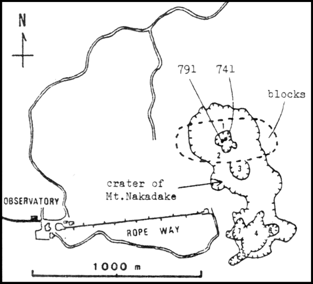 |
Figure 1. Map of the summit area of Naka-dake at Aso. Naka-dake's crater includes smaller craters 1-7 (hachured lines). Vents 741 (active since 1974) and 791 (formed during the June activity) are shown in crater 1. The dashed line delineates the area where tephra larger than 3 cm in diameter fell during June, 1979. Courtesy of JMA. |
Frequent periods of activity, consisting of weak and continuous ash emission or explosive block ejection, occurred daily until 25 June. Incandescent coria was seen at night on the 14th, 15th, and 16th. A new vent (791 pit) was formed during the June eruption at the bottom of Crater 1 near 741 pit, which had been active since 1974 (figure 1). Since the end of June, activity has declined to occasional weak ash emission. Seismicity remained low in June, in contrast to the strongly increased seismicity that accompanied the eruptions of 1977 (figure 2).
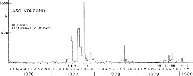 |
Figure 2. Number of recorded seismic events per 10-day period at Aso, January 1976-March 1980. Arrows represent eruptions. [Originally from 05:04.] Courtesy of JMA. |
Information Contacts: JMA.
Mid-June eruption successfully predicted, but activity continues, killing two in September
"The eruption of Aso continued through July (table 1). Seismicity remained low. It is empirically known for Aso volcano that the amplitude of continuous tremor becomes large before an eruption and remains large throughout the eruptive period (figure 3).
Table 1. Activity at Aso, late May-29 September 1979. Ash thicknesses, at about 1 km from the source, were estimated by weighing the small amount of material accumulated in a measured area. Courtesy of JMA.
| Date (1979) | Activity |
| late May-early Jun | Intermittent phreatic eruptions; wet ash and blocks fell on crater floor, common activity at Aso. |
| [09] Jun | Felt earthquake [at 0904]. |
| 11 Jun | Continuous tremor amplitude increased during the morning; [zone 1 km from crater closed] at 1310. |
| 12 Jun | Further tremor amplitude increase in the morning but sudden decrease in amplitude at 1821; ash eruption began in the evening; a few incandescent blocks seen at night. |
| 13 Jun | Further tremor amplitude decrease at 0336, then steep increase at 1457; large explosion at 1510 produced a 2-km-high ash cloud; blocks fell 350 m from the vent. |
| 14 Jun-15 Jun | Intermittent ash eruptions; incandescent blocks; very loud rumbling ([people said] the strongest in 50 years) began at 2340 on 15 June and lasted until the next morning, rattling doors an windows. |
| 16 Jun | Activity decreased briefly in the morning, but loud rumbling resumed at 1110 and explosions started again, ejecting incandescent scoria. |
| 17 Jun-26 Jun | Ash ejection every day; 25 cm deposited in the summit area 12-23 June; rumbling declined during the morning of the 18th, then resumed at 0950 on the 20th, continuing through 27 June; block ejection was observed on 3 days, and reflected glow could be seen on 22 and 23 June; lightning was seen on 19 June. |
| 27 Jun-30 Jun | Poor weather prevented observations; estimated volume of ejecta in June, 1.4 million tons. |
| 01 Jul-05 Jul | Ejection of ash and incandescent blocks, accompanied by rumbling; largest scoria bombs measured at 86 cm in diameter. |
| 06 Jul-19 Jul | Ash ejection and weak rumbling; no blocks observed. |
| 20 Jul-31 Jul | Ash and incandescent blocks ejected; lightning and reflected glow seen; continuous weak rumbling, punctuated by occasional louder periods; July ejecta volume estimated at 1.64 million tons. |
| 01 Aug | Ejection of ash and incandescent blocks; reflected glow; lightning. |
| 02 Aug-03 Aug | Ejection of ash and incandescent blocks; lightning. |
| 04 Aug | Ash ejection; lightning. |
| 05 Aug-06 Aug | Ejection of ash and incandescent blocks. |
| 07 Aug | Bad weather -- no observations. |
| 08 Aug-09 Aug | Ejection of ash and incandescent blocks; lightning. |
| 10 Aug | Ejection of ash and incandescent blocks stopped about 1300, then loud rumbling began. |
| 11 Aug-26 Aug | Loud rumbling; white steam emission, a few ash ejections. |
| 27 Aug | 161 mm of rainfall; rumbling stopped; steep decline in continuous tremor amplitude at 0900. |
| 28 Aug-05 Sep | No eruptive activity [but slight ashfall 5 September]; tremor remained weak. |
| 06 Sep | Large explosion at 1306, killing three persons; tremor amplitude increased sharply at 1350 then decreased gradually over the next 14 hours. |
| 07 Sep-12 Sep | White steam emission; weak tremor. |
| 13 Sep-22 Sep | Quiet; no ashfalls observed. |
| 23 Sep | Ash eruption, lasting about 10 minutes. |
| 24 Sep | 10-minute ash eruption in the morning; continuous ashfall 1450 until night; accumulation less than 0.1 mm. |
| 25 Sep-26 Sep | No ashfalls observed. |
| 27 Sep | Continuous ashfall from 0540 to 1730, accumulating about 0.2 mm. |
| 28 Sep | No ashfalls observed. |
| 29 Sep | About 0.1 mm of continuous ashfall between 1510 and 1645. |
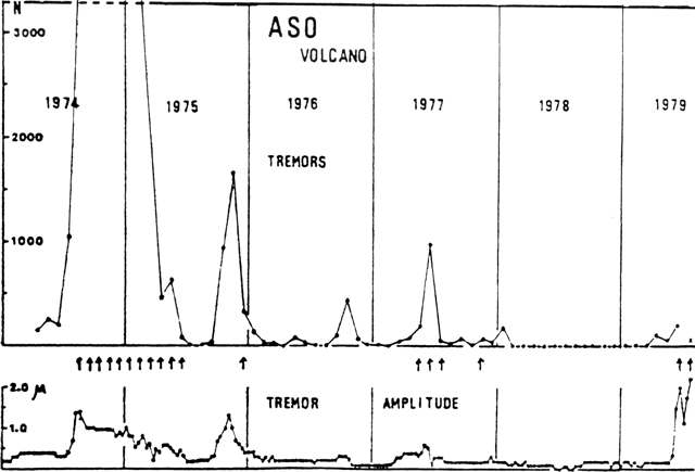 |
Figure 3. Aso seismicity since 1973. Monthly number of isolated tremor events (top) plus 10-day means of continuous tremor anplitudes during the same period (bottom). Arrows show months in which Aso was erupting. Courtesy of JMA. |
The local disaster control group for Aso volcano [closed the area within 1 km of the crater] at 1310 on 11 June because high-amplitude continuous tremor had begun to be recorded at JMA's Asosan Weather Station [originally referred to as Aso Observatory] during the early morning. Civil Defense personnel kept people 1 km from the crater, visited by many persons when the volcano is inactive. The eruption began during the evening of 12 June. No casualties have occurred.
"The second characteristic event of this eruption was the decrease in the amplitude of the continuous tremor just before the largest explosion, on 13 June. The extraordinary decrease in amplitude was observed for 11 and 1/2 hours, from 0336 to 1457 on the 13th. The explosion occurred at 1510, after a steep increase in tremor amplitude for 13 minutes. Many cases of a decrease in tremor amplitude before a larger explosion are known for past eruptions at Izu-Oshima and Aso. For example, a decrease lasting four days was recorded before Aso's large explosion of 31 October 1965."
Kyodo radio reported that [three] persons were killed and [11] injured by blocks ejected at about 1300 on 6 September. The area within 1 km of the active vent remained off limits.
Information Contacts: JMA; Kyodo radio.
Large explosion kills three, then activity declines
"Eruptive activity continued through early September. Ash eruptions occurred almost every day from mid-July until 10 August (table 1) and ash fell on towns near the volcano; ash reached Takeda City, 30 km NE of Aso, in early August. Strong rumbling resumed on 10 August, but the volcano suddenly stopped emitting ash at about 1300 that day. The rumbling lasted until 26 August and was occasionally heard at the towns of Aso-machi and Ichino-miya-machi, 10 km from the crater. A steep decrease in the amplitude of the recorded continuous tremor took place at about 0900 on 27 August and the volcano was very quiet (no ash or block ejection, nor any rumbling) until 6 September.
"A loud explosion occurred at 1306 on 6 September. A dark ash cloud, in which lightning was seen, rose 700 m. The air shock reached 0.8 millibars and the ground shock had an amplitude of 17 µm at the JMA's Aso Observatory, 1.2 km from the crater. Three tourists were killed, two injured seriously, and nine slightly, by falling blocks 10-20 cm in diameter at a site 0.9 km from the vent (figure 4). Numerous blocks pierced the roof of a ropeway station (also 0.9 km from the vent), made of concrete as thick as 25 cm. A few of the lesser injuries occurred inside the station house. People said that the blocks that fell around the station house were hot and the cores of some of them were dimly glowing. Ash reached Oita city, 65 km NNE of Aso. The activity declined to white vapor emission 7 minutes after the explosion and no further eruption had occurred as of 12 September.
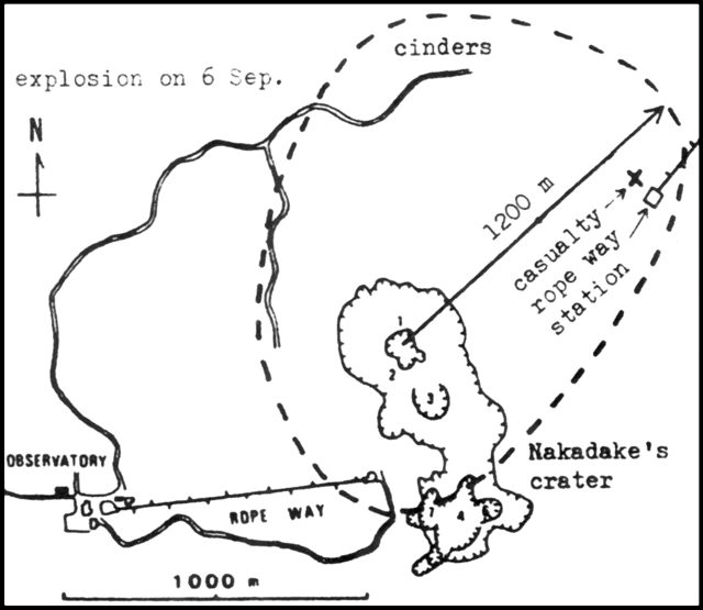 |
Figure 4. Summit area of Aso. Casualities from the 6 September 1979 explosion took place at the site marked X. Cinders larger than 3 cm fell in the area enclosed by a dashed line, a maximum of 1,200 m from the vent, Crater 1 of Naka-dake. Craters 1-7 are shown within the larger Naka-dake Crater, by hachured lines. Courtesy of JMA. |
"The amplitude of recorded continuous tremor remained small (about 2 µm) through the explosion, became large (to 17 µm) 40 minutes after the explosion, then declined gradually to around 5 µm 14 hours after the explosion. It is not known whether the low-amplitude stage, which lasted from 27 August to just after the explosion, was an example of `amplitude decrease prior to explosion' (4:8). Seismicity remained relatively low both before and after the explosion.
"The restricted area [designated] on 11 June by the local disaster control committee for Aso volcano was still [closed] on 6 September. The committee will reexamine the size of the restricted area (within 1 km of the crater), although the casualties occurred in this area.
"The summit area of Naka-dake was surveyed by JMA personnel and by Koji Ono of the Japan Geological Survey 8-11 September. Cinders larger than 3 cm were scattered in the area enclosed by a dashed line in figure 4, reaching 1.2 km from Crater 1. A large block found 0.3 km from Crater 1 was 4.6 x 2.6 x 2.6 m and weighed about 50 metric tons. No scoria or other essential fragments were found. The explosion is considered to be a steam explosion, and may have been caused by heavy rainfalls on 27 August (161 mm) and 3-4 September (127 mm)."
Further Reference. Wada, T., Kikuchi, S., and Ono, H., 1980, The explosion of Naka-dake, volcano Aso on the 6th of September, 1979: Bulletin of the Volcanological Society of Japan, v. 25, p. 245-253.
Information Contacts: JMA.
Occasional weak ash emission
After the large 6 September eruption that killed three persons, Aso remained quiet through 22 September. Occasional weak ash emission took place 23-29 September (table 1). All of the eruptive activity occurred from the 6 September vent.
Information Contacts: JMA.
Frequent ash emission; explosion successfully predicted
Frequent ash ejections resumed on 24 September and continued through late November. During October, no blocks were seen to reach the rim of Naka-dake Crater nor were incandescent blocks observed at night. By the end of October, the concentration of ash at the JMA's [Asosan Weather Station] (1 km from the active vent) had reached more than 10 kg/m2, equal to about 1 cm of ash thickness. Although continuous tremor amplitude had correlated well with June-September eruptive activity, amplitudes remained low (about 0.5 µm) during October. The number of local earthquakes also remained low in October.
A characteristic decrease in the amplitude of continuous tremor began at about 0900 on 2 November, lasting until a large explosion at 1626. An eruption cloud rose 1.5 km above the crater during about an hour of ash ejection. Four mm of ash fell at the [Weather Station]. A survey by [Weather Station] personnel two days later found scoria up to 200 m from the vent, overlying 0.6 m of ash that had fallen in the summit area since the eruption began 12 June. The tremor amplitude decrease was the third since June that had preceded a sizeable explosion. An alert was issued from the Observatory one and a half hours before the explosion. No casualties occurred.
Ash emission in November was stronger than in October, causing heavy ashfalls near the volcano. Slight ashfalls occurred occasionally at Mt. Takachiho (110 km S), Kumamoto city (40 km W), and in Oita Prefecture (50 km E). Ejection of incandescent blocks was observed at night on 11 and 19 November, for the first time since 6 August. Tremor amplitude increased through most of November, but declined late in the month. The Strombolian activity of June, July, and early August occurred while tremor amplitude was high.
Further Reference. Tanaka, Y., Tsuchiya, Y., and Yamaura, Y., 1981, Detection of volcanic smoke and ashfall area at Aso from Landsat data: Papers in Meteorology & Geophysics, v. 32, no. 4, p 275-291.
Information Contacts: JMA.
Short explosive eruption; 1979 activity reviewed
Activity stopped on 28 November after strong ash emission through most of the month (table 2). Between June and November, ash caused about 1 billion yen ($4 million) in damage to crops and forests. No further ashfalls were observed until an explosion at 2107 on 26 January deposited 3 cm of ash and fist-sized scoria on the rim of Naka-dake, the source crater. A small amount of ash fell on Aso-machi town, at the base of the volcano. The explosion caused no damage, and the volcano returned to quiescence the next day.
Table 2. Monthly ashfall in thousands of tons, June-December 1979, as estimated by personnel from JMA's [Aso-san Weather Station].
| Month | Ashfall (tons) |
| Jun 1979 | 1,420,000 |
| Jul 1979 | 1,620,000 |
| Aug 1979 | 1,590,000 |
| Sep 1979 | 300,000 |
| Oct 1979 | 970,000 |
| Nov 1979 | 3,270,000 |
| Dec 1979 | 0 |
| TOTAL | 9,170,000 |
Information Contacts: JMA.
Small ash emission
A weak and brief emission of ash from Aso occurred on 8 March, producing ashfall on the S flank. Since strong ash emission stopped on 28 November 1979, eruptive activity had been confined to ejection of a small amount of ash and scoria, accompanied by a strong air and ground shock, on 26 January, and emission of white vapor at other times.
The amplitude of continuous tremor recorded at [Asosan Weather Station] declined in December 1979 and has remained low through March (figure 5). The number of local earthquakes increased somewhat around the January tephra ejection, but declined in February and did not increase substantially during the March activity.
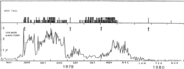 |
Figure 5. Daily mean amplitude of continuous tremor (bottom) and occurrence of ash emission (top) observed from the JMA's Aso-san Weather Station, May 1979-March 1980. Larger ashfalls are represented by longer lines in the top section. The arrows in the bottom section indicate strong explosions on 13 June, 6 September (three persons killed), 2 November 1979, and 26 January 1980. Courtesy of JMA. |
Information Contacts: JMA.
Activity declines
Activity at Aso has been confined to weak but steady emission of white vapor since the brief 8 March ash ejection. The number of seismic events per day and the amplitude of the continuous tremor recorded at [Asosan Weather Station] were both small in April and early May.
Information Contacts: JMA.
Small ash emission
A brief, weak explosion on 24 September ejected ash to about 800 m above Crater 1 of Naka-dake [after quiescence since the 8 March ash ejection]. The area within 1.5 km of the summit was closed immediately after the explosion but reopened 2 days later.
Information Contacts: JMA.
30-minute ash and block ejection
Ash and block ejection from Crater 1 of Naka-dake, the northernmost of 7 in Naka-dake, was observed at 1230-1300 on 15 June, after 9 months of quiescence. Blocks rose to 30 m, but fell within the 100 m-diameter crater. 1 µm ground shocks were recorded at 1239 and 1244, and a 3.7 µm shock at 1251 [at the Weather Station]. Activity then subsided. The explosions caused no damage. The area within 1 km of the summit, closed immediately after activity began, was reopened 17 June. Asosan Weather Station personnel [visited the crater on 15 June and] observed that the greenish water pooled in Crater 1 since October had become gray tinted [but returned to its usual green the next day]. The [level of some points on the surface of the water] rose intermittently. Naka-dake is the historically active part of the Aso volcanic complex.
Information Contacts: JMA.
Block and ash ejection from fumarole
A warning of increased volcanic activity was issued by the [Asosan Weather Station] on 11 October. On the morning of 24 October, ash was ejected from a fumarole that had formed in mid-September on the lowest part of the E inner wall of [Crater 1 of] Naka-dake. A small gray plume rose to 300 m above the fumarole at 0920, but the ejection was too weak to send ash beyond the crater rim. Entry to the area within 1 km of the crater was prohibited shortly before 1000. Another plume rose to 200 m at 1030 the next day, accompanied by intermittent ejection of small blocks, as large as fist size. Activity had subsided by 1550.
The level of water in Crater 1 has gradually decreased since early April (figure 6). A part of the crater bottom could be seen in mid-September. As of 26 October, only 30% of the bottom was covered by the hot water.
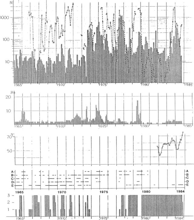 |
Figure 6. Activity at Aso Volcano, 1965-84. Top to bottom: monthly number of isolated tremor episodes (open circles connected by dashed lines) and volcanic earthquakes (bars); monthly averaged amplitude of continuous tremor; Monthly maximum surface temperature of water in Naka-dake's Crater 1; eruptive phonomena--block ejection (A), ash ejection (B), volcanic flame (C), red-hot lava at the bottom of Crater 1 (D), and ash and mud ejection (E); quantity of water pooled in Crater 1--small amount (1), intermediate amount (2), full (3). Courtesy of JMA. |
Information Contacts: JMA; A. Izumo, Yokohama Science Center; Japan Times; Kyodo News Service.
Emission of ash containing fresh magma
Activity has gradually increased at Crater 1 of Naka-dake. After weak ash emission 2-3 January, an ash-laden plume has been occasionally observed since 11 January. A gray plume rose to 700 m above the crater rim on the 18th. . . . The ash included juvenile material.
Information Contacts: JMA.
Moderate ash emissions continue; volcanic flame on two nights
Ash was ejected a little more vigorously on 31 October, rising to the crater rim (about 100 m above the vent). On 2 November, ashfall was again confined to the crater. On 5-6 November weak rumbling was heard at the JMA's Aso Weather Station, 1.2 km SW of the crater.
Occasional weak ash emission that continued after 2 November was interrupted by water flowing into the active vent on 12 November. From then until 30 December muddy water and small rocks were ejected almost continuously, at varying intensity. During the strongest activity, on 9 December, this mixture fountained to an average height of 10 m above the crater floor, sometimes to more than 20 m.
Moderate ejections of ash to 150 m (as high as the crater rim) resumed 30 December and ended 2 January. On 30 December at 0815 an ash-laden plume rose 200 m above the rim. Ash fell on the S slope of the crater . . . . A prohibited zone within 1 km of Crater 1 was established 28 November.
On 11 January a grayish plume was observed rising 400-500 m above the crater rim, where ashfall was 1 cm thick. A little ash also fell on the S flank. Since the 11th an ash-laden plume was observed almost every day in January. Activity increased slightly on 18 January, when a gray plume rose 600 m above the rim. Volcanic flame [from a pit on the crater floor] was observed [during visits] the nights of 21 and 25 January.
Information Contacts: JMA; A. Izumo, Yokohama Science Center; Japan Times.
Moderate ash emission; volcanic flame
Moderate ash-laden emissions from Naka-dake were occasionally observed in February and March. Gray plumes were seen on 8, 17-18, and 25-28 February. Ash accumulation on 26 February was 295 g/m at JMA's [Asosan Weather Station] (at the SW foot of Naka-dake [1.2 km from the crater]). On 1 March, the emission from the pit that had been active from January through February declined rapidly, although a new pit formed about 40 m N of the older one. Ash emission resumed the next day. Volcanic flame [from the pit on the crater floor was observed during visits] the nights of 6 and 25 March.
In late December, the press reported that volcanic tremors were continuously felt. However, JMA noted that average tremor amplitude was within the range of 0.1-0.3 µm through December and January. As of 1 April, tremor remained at about the same level.
Information Contacts: JMA.
Moderate tephra emission; new vent
Moderate ash-laden emissions from Crater 1 of Naka-dake were observed on almost every day in April (some daily ash accumulations are listed in table 3). Volcanic flame had been observed rising 20-40 m above [the pit in] the floor of Crater 1 on 25 March, and the remainder of the water pool in the crater disappeared on 16 April. Average tremor amplitude remained at around 0.3 µm in April.
Table 3. April-May 1985 daily ash accumulation at the JMA's Aso-san Weather Station, 1.2 km SW of Crater no. 1 of Naka-dake. [Ash was measured each day at 0900 and represents the amount deposited the previous 24 hours. There was no accumulation on other days in April and May.]
| Date | Ash (g/m2) |
| 02 Apr 1985 | 141 |
| 06 Apr 1985 | 130 |
| 07 Apr 1985 | 14 |
| 12 Apr 1985 | 338 |
| 13 Apr 1985 | 37 |
| 12 May 1985 | 2.5 |
| 14 May 1985 | 1550 |
| 16 May 1985 | 757.9 |
| 22 May 1985 | 119.7 |
On 6 May, a small eruption was observed at a new pit about 10 m E of the one that had formed on 1 March. Rocks several tens of centimeters in diameter rose to a height of 50 m above the floor of Crater 1 and ash-laden emission was almost continuous from the 1 March pit. It was not certain if juvenile material was included in the 6 May tephra.
Information Contacts: JMA.
Ejection of ash and incandescent tephra
Since October 1984, activity has gradually increased at Naka-dake, site of all of the more than 140 eruptions known from the Aso complex in historic time. Activity at Crater 1 increased in May. Ash accumulated at JMA's Asosan Weather Station on 12, 14, [16], 22, 23, 29, and 30 May (table 3). An ash-laden plume was observed almost daily (figure 7). On the morning of 6 May, incandescent blocks were ejected at a new vent that had not been present the previous day. Block ejection stopped on 8 May but resumed on 15 May, when the vent increased to 40 m diameter by collapse of a wall between it and another vent that had formed in March. Incandescent blocks, including scoria a few tens of centimeters in diameter, were ejected to 50 m above the crater floor. Ash and mud jetted to the level of the top of the wall that had separated the two vents.
 |
Figure 7. Table showing activity at Aso in May 1985. Y = observed; N = not observed; - = not observed because of bad weather. Courtesy of JMA. |
Incandescent blocks were occasionally ejected at the vent after 16 May. The most powerful May eruption occurred on the morning of the 30th; larger amounts of incandescent blocks (mainly scoria) as much as 1-2 m in diameter were ejected 120-130 m above the crater floor at 1020. The intensity of ejection then gradually declined.
Information Contacts: JMA.
Ash emision ends
Activity at Aso has gradually increased since October 1984. Moderate ash emissions from Crater 1 of Naka-dake were observed almost daily from the beginning of May (10:6) until 20 June. White steam vapor dominated for the last 10 days of the month. Total June ashfall at JMA's [Asosan Weather Station] was 1429 g/m22.
Activity declined in July, when neither ash plumes nor deposits were observed at the [Weather Station]. On the morning of 1 July, [Weather Station] personnel found that the vent on the floor of the crater had been covered by water from heavy late-June rains. The level of water within the crater gradually rose in early July. About 70% of the crater floor has been covered by hot (60°C) water since mid-July. There were many fumaroles along the margin of the pool, and sand and water were ejected at many points on the surface. Seismic activity remained low throughout June and July.
Information Contacts: JMA.
Tremor stronger and more frequent; mud ejection
The number of tremor episodes recorded by a seismograph 0.8 km from [Crater 1] increased sharply to ~5,900 in May from the typical 100-500/month (figure 8). Activity declined slightly beginning 30 May to about 100 tremor episodes/day by 6 June. Background tremor was continuous and amplitudes in May were twice usual values (figure 10). The floor of Naka-dake's crater 1 had been covered by a pool of water that gradually dried up toward the end of May. Mud ejection about 10 m high from the crater bottom was observed during a field survey 26-27 May. Public access to the area around the crater was prohibited 25 May-6 June.
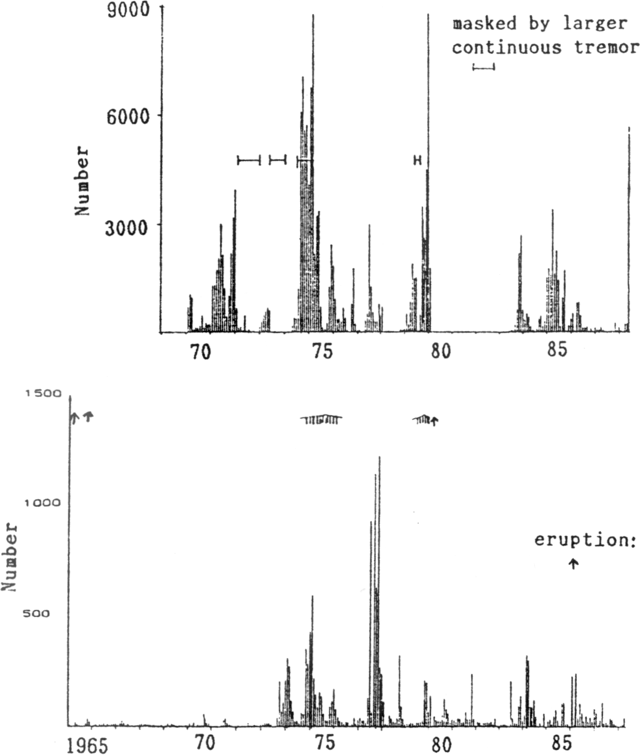 |
Figure 8. Monthly number of tremor episodes at Aso, January 1970-May 1988 (top), and monthly earthquakes, January 1965-April 1988 (bottom). Bars mark periods in which continuous tremor masked individual tremor episodes. Courtesy of JMA. |
Information Contacts: JMA.
Glow on crater floor; crater closed to tourists
On the night of 16 October, JMA geologists noted irregular areas of red glow in a 30 x 10 m area on Naka-dake's crater floor, the first glow seen there since June 1985. The local government prohibited access within 1 km of the crater 17-27 October. Steam emission was observed from Crater No. 1 and its small crater lake shrank. The lake temperature was 71°C on 1 October. Seismicity and tilt showed no significant changes.
Information Contacts: JMA.
Minor ash emission
Ash ejection from [Crater 1] was observed on 28 December at 1420, during a field survey. The ash cloud rose 30 m above the crater rim. Red glow at vents and cracks in the crater floor had often been seen since 16 October. The number of isolated tremor episodes, counted from data recorded on a seismometer 0.8 km W of the crater, had gradually increased since the end of October, although the amplitude of continuous tremor episodes remained almost the same. No ash ejection was observed during a 31 December field survey.
Information Contacts: JMA.
Ash ejection; tremor increase; crater closed to tourists
About 3,000 volcanic tremor episodes were recorded during March, twice the number recorded in January and February (figure 9). A significant increase was recorded 22 March on a seismometer 0.8 km W of Crater 1. The amplitude of continuous tremor was generally unchanged.
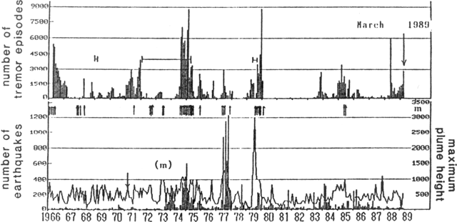 |
Figure 9. Monthly number of isolated volcanic tremor episodes at Aso (top), earthquakes (bars, bottom), and maximum plume heights (curve, bottom), 1966-March 1989. Arrows mark periods of explosions. Courtesy of JMA. |
Early 5 April, ash was ejected to ~50 m above a vent ~100 m below the crater rim. A field survey at 1140 the next day revealed that ash emission had stopped. A 1-km area (the smallest of three designated zones) around the crater was closed to tourists by the Aso Disaster Prevention Authority, at 0920 on 5 March. Such a restriction is necessary a few times a year when activity increases.
On 12 April, the restricted zone was reopened. Ash had not been ejected since 6 April although the frequency of tremor episodes remained high at 200/day. Glow at vents and cracks on the crater floor was regularly observed during night visits from October 1988 through April 1989.
Information Contacts: JMA.
Brief ash emission
On 27 April, the staff of AWS visited the crater rim as they have every day for the past 20 years. A vent on the SE floor of Crater 1 was releasing yellow vapor and ash to 30 m, accompanied by larger tephra. The Aso Volcano Disaster Prevention Authority closed a 1-km area near the crater to tourists. The area was reopened 2 May, when a field survey revealed only white vapor reaching ~5-6 m above the vent.
Glow on the crater floor has been observed every night since October 1988. A maximum temperature of 232°C was measured (with a infrared radiation thermometer) at a glowing site on 18 April.
Isolated tremor remained frequent in April. The daily number of tremor episodes was 100-250, with a monthly total of ~5,760 (figure 10). Amplitude of continuous tremor remained the same.
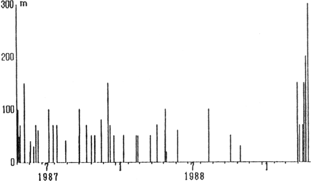 |
Figure 10. Monthly number of isolated volcanic tremor episodes at Aso (top), earthquakes (bars, bottom), and maximum plume heights (curve, bottom), 1966-April 1989. Arrows mark periods of explosions. Courtesy of JMA. |
Information Contacts: JMA.
Ash ejections continue; new vent on crater floor
After a small ash ejection 5 April, tephra emission continued at a relatively high rate in May and June. On 8 May at 1000, a vent (1 m in diameter) on the Naka-dake crater floor ejected ash to ~10 m. At 1132, an M 3.3 shock (3 on the JMA Intensity Scale) occurred beneath the crater and was felt at AWS. Five (felt) aftershocks were recorded on 8 May (at 1120, 1147, 1216, 1417, and 2039), and 1 (not felt) was recorded the next day (at 0057) by a seismograph 0.8 km W of the crater. A 1-km area around the crater was closed to tourists by the Aso Disaster Authority. During a field survey at 1910, no ash ejection was observed.
On 16 May, ash rose ~100 m above the crater rim at 0810, and ~200 m at 1030. About 20% of the crater floor was covered by a rainwater pool, from which mud and water were continuously ejected to 3 m. During a field survey on 20 May at 1150, a strong rumbling noise was audible, but no ash ejection was seen.
Ash rose ~200 m above the crater rim on 22 May from 0740 to 0800, and 20 m above the crater floor at 0820. Activity declined, stopping by 1000. Two days later at 1000, ash was ejected to 200 m above the crater rim, and 5 g/m2 of ash was deposited at AWS. Ash had not fallen there since 28 June 1985. Red glow at the vent and in cracks on the crater floor was observed at night through May. During the night of 27 May, red glow emanated from 40-50% of the crater floor. On 28 May, ash rose about 50 m from the N portion of the vent.
In June, a vent on the NW floor of Crater 1 emitted an ash-laden steam plume a few hundred meters above the crater rim. During a 6 June field survey, the vent had enlarged and was emitting a 300-m ash plume. Flames from burning volcanic gases were occasionally observed rising 3-4 m above the crater floor during night visits. Ash accumulation at AWS was 9 g/m2 on the 7th, and 2 g/m2 on the 8th. The Crater 1 vent was buried by ash during rainfall 8-9 June. A new vent (named "891") about 18 m in diameter opened in the center of the crater floor on 10 June, and was the largest new vent since "853" formed 6 May 1985. The highest plumes of the month reached 1,000 m above the crater rim on 7 and 20 June.
Isolated volcanic tremor remained high (200-400 events/day) in May and June (figure 11) with a total of 5,760 events in May and 6,752 in June (compared to 5,821 in April). The amplitude of continuous tremor was generally unchanged in May but increased slightly in June.
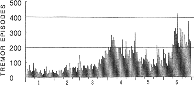 |
Figure 11. Daily number of isolated tremor episodes at Aso, January-June 1989. Courtesy of JMA. |
Information Contacts: JMA.
First strong eruption since 1985 ejects ash to 2,500 m
On 16 July, Aso erupted vigorously for the first time since May-June 1985, with three ash explosions from Crater 1 (at 1354, 1603, and 1625). The eruption resumed on 24 July, ejecting ash to 2,000 m above the crater rim.
Activity at Crater 1 has been gradually increasing since the end of 1988 (figure 12). Visits to the volcano October 1988-5 August 1989 revealed red glow at vents and cracks on the crater floor. After a small ash ejection on 5 April, tephra emission continued at a relatively high rate in May and June. A new vent (891) on the crater floor, first noticed during a field survey 11 June, emitted an ash-laden plume almost every day in July. Ash often fell near the vent, and daily accumulations of 7 g/m2 on 6 July, 11 g/m2 on 7 July, and 6 g/m2 on 8 July were measured at AWS.
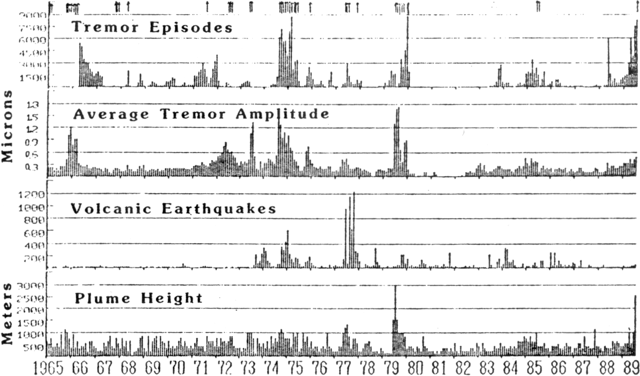 |
Figure 12. Monthly number of isolated volcanic tremor episodes, average tremor amplitude, number of volcanic earthquakes, and maximum plume heights at Aso, January 1965-July 1989. Arrows represent eruptions. Courtesy of JMA. |
On 14 July, the largest daily number of isolated volcanic tremor episodes (744) in 1989 was recorded by a seismometer 0.8 km W of Crater 1 (figure 13). The same day, at 1535, the amplitude of continuous tremor increased (figure 14), and white vapor and ash from Vent 891 was ejected to 1,200 m. A 1-km area around the crater was again closed to tourists by the Aso Disaster Prevention Authority. Two days later, at 1155, tremor amplitude began to increase, decreased sharply at 1303, but increased again at 1344, 10 minutes before the onset of ash emission. Ash reached about 2,500 m height at 1355. After a sharp decrease in tremor amplitude, two ash explosions followed at 1603 and 1625, ejecting a plume to ~1,000 m.
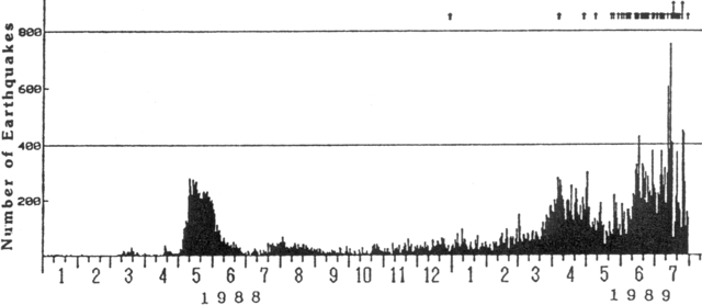 |
Figure 13. Daily number of isolated tremor episodes at Aso, January 1988-July 1989. Arrows represent eruptions. Courtesy of JMA. Courtesy of JMA. |
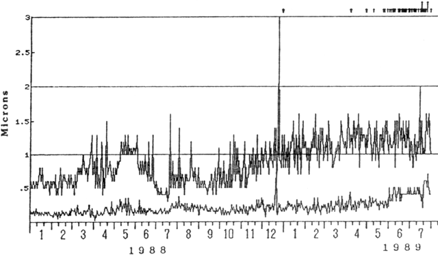 |
Figure 14. Daily maximum tremor amplitude (top) and average amplitude of continuous tremor (bottom) at Aso, January 1988-July 1989. Arrows represent eruptions. Courtesy of JMA. |
On 18-19 July, small amounts of ash were repeatedly ejected from Vent 891 after tremor amplitude sharply decreased. During a field survey at 1920 on 22 July, a maximum brightness temperature of 506°C was measured (by an infrared radiation thermometer) at a vent on the crater floor. The amplitude of continuous tremor began to increase 21 July, and significantly increased on the night of 23 July. Ash emission resumed at 1620 on 24 July and continued for about 1 hour, attaining a maximum height of 2,000 m above the crater rim. A small ash ejection was observed during a field survey on 29 July. Brightness temperatures near the vent on the crater floor were 504°C on the 29th and 498°C on the 30th. The average amplitude of continuous tremor remained high.
Information Contacts: JMA.
Stronger ash emission
An ash ejection on 14 August at 1050 was the fifth since a series of explosions began on 16 July (14:07). Ash emission continued for about 90 minutes, sending a blackish-gray plume to ~1,000 m above the crater rim. Amplitude of continuous tremor during the eruption was about 0.6-0.7 µm (on a seismograph 0.8 km W of the crater), compared to an average amplitude of 0.3-0.4 µm. Intermittent ash ejection continued almost daily through August, with ashfall often observed around Crater 1. During the month, a total of 787 g/m2 of ash accumulated at AWS about 1 km SW of the crater. Ash emitted 20-24 August reached villages ~40 km NW of the crater, the most distant ash deposition since 1979. On 4 September, the amplitude of continuous tremor decreased for a few minutes, followed by ash ejections at 0905 (1,000-m plume), 1300 (700 m), 1540 (2500 m) and 1725 (2,500 m). A 1-km area around the crater has been closed to tourists by the Aso Disaster Authority since 9 August.
Burning gas from the crater floor's 891 vent was observed almost daily during August. The flame was 30 m high on the night of the 23rd, the highest since burning gases were first seen in June, and a 15-m flame was seen the next day.
Information Contacts: JMA.
Continued tephra emission
Eruptive activity (from 891 vent in Naka-dake's Crater 1) began on 16 July, and by 5 October, 14 ash eruptions had been recorded (table 4). During clear weather in September, vent 891 (first seen 11 June; see SEAN Bulletin 14:06) was observed emitting an ash-laden plume almost daily. On the 27th from 0900 to 1330, continuous ash emission produced a 3000 m plume (the highest of the month) that deposited ash about 55 km E. [Daily ashfall at Aso Weather Station, 1 km WSW of the volcano, in September 1989 (in g/m2) was as follows: 5 (73), 6 (1,188), 8 (18), 9 (9), 11 (11), 16 (57), 17 (48), 20 (11), 24 (306), 30 (1,000).]
Table 4. Plume heights and colors for eruptions 1 July-5 October 1989. The Japan Meteorological Agency uses the term "eruption" to distinguish more voluminous ash ejections from low-level continuous ash emission. Data courtesy of JMA.
| Date | Time | Color | Plume Height (m) |
| 16 Jul 1989 | 1354 | -- | 2,500 |
| 16 Jul 1989 | 1603 | -- | 1,000 |
| 16 Jul 1989 | 1625 | -- | 1,000 |
| 24 Jul 1989 | 1620-1720 | -- | 2,000 |
| 14 Aug 1989 | 1050 | Blackish gray | 1,000 |
| 04 Sep 1989 | 1540 | Grayish white | 2,500 |
| 04 Sep 1989 | 1725 | Grayish white | 2500 |
| 07 Sep 1989 | 1650-1840 | -- | 3,000 |
| 16 Sep 1989 | 1400-1450 | -- | 2,200 |
| 27 Sep 1989 | 0900-1330 | -- | 3,000 |
| 29 Sep 1989 | 0330-1610 | Grayish white | 1,500 |
| 29 Sep 1989 | 1650-1930 | Grayish white | 600 |
| 30 Sep 1989 | 0925-1830 | Grayish white | 1,500 |
| 01 Oct 1989 | 1245-1630 | Grayish white | 1,000 |
| 02 Oct 1989 | 1205-1650 | Grayish white | 1,000 |
Red glow from vent 891 was seen almost daily from the rim of the crater. A maximum September vent temperature of 535°C was measured by an infrared radiation thermometer on the 6th. During a field survey 26-27 September, burning gas from the vent reached 50 m height.
The number of isolated volcanic tremor episodes (recorded by a seismometer 0.8 km W of Crater No. l) increased in September, with 720 events on the 18th and 702 on the 27th (figure 15). On the 26th, the month's largest tremor amplitude, 7.7 microns, was recorded.
 |
Figure 15. Seismicity at Aso, 1 March 1988-2 October 1989. Daily number of isolated tremor episodes (top); daily maximum and average amplitudes of volcanic tremor episodes (bottom). Courtesy of JMA. |
Information Contacts: JMA.
More explosions; stronger tremor; new vent
Recorded explosions became more frequent in mid-October, occurring almost every day during the second half of the month (see table 4), for a total of 29 since 16 July. Minor ash emission occurred on most days in October, causing ashfalls around the crater. Ash reached AWS during favorable wind conditions, and by 21 October had accumulated to 3 cm depth (11,409 g/m2). On 27 October, 8437 g/m2 of ash was deposited at AWS, and slight ashfall was observed at Kumamoto Local Meteorological Observatory, ~35 km SW of Aso. The heavy ashfalls damaged agricultural products. A zone within 1 km of the crater remained closed to tourists by the Aso Disaster Authority.
Block ejection, to 10 m height, from Vent 891 was first seen during a 6 October field survey. During 9 October fieldwork, a new vent (named 892) about 1-2 m in diameter was observed about 10 m N of Vent 891, intermittently ejecting fist-sized blocks to 20 m height. Ash emission continued from 891 vent, but no blocks were ejected. The next day, Vent 892 had grown to ~5 m in diameter. By 21 October, the new vent had enlarged further to 25 m across, coalescing with 891 the following day.
Flames from burning gases rising several tens of meters from the vent were often seen at night. Strong rumbling was sometimes audible at AWS, and rumbling was heard 10 km to the ESE (at Takamori) during the 28 October eruptive episode.
The number of isolated tremor episodes increased toward the end of October (figure 16). The amplitude of continuous tremor, recorded by a seismograph 0.8 km W of Crater 1, grew particularly large from mid-October, reaching a maximum of 12.8 µm on the 21st.
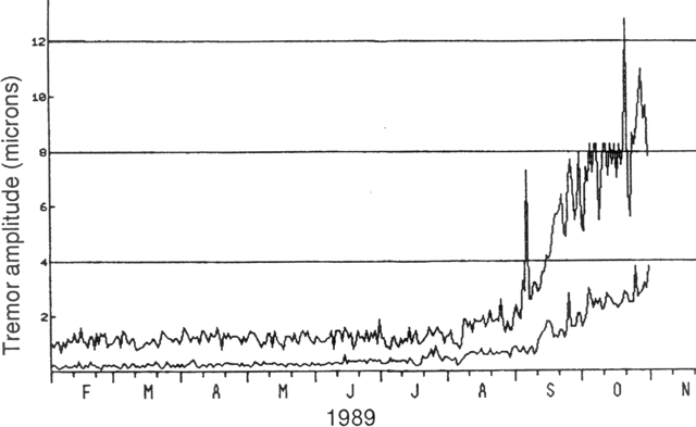 |
Figure 16. Daily maximum and average amplitudes of volcanic tremor episodes, 1 February-10 November 1989. Courtesy of JMA. |
Information Contacts: JMA.
Frequent tephra ejection continues
Eruptive episodes have been recorded on 36 days since 16 July, including 11 days in November (see table 4). Minor ash emission, without recorded explosions, occurred on most days in November, causing ashfalls around the crater. The month's ash accumulation at AWS was 1,409 g/m2. The 23 November eruptive episode, accompanied by lightning, ejected blocks to 300 m above the crater rim; blocks had begun to be thrown over the rim as recorded explosions became more frequent in mid-October. During a 24 November field survey, fist-sized blocks were seen 700 m SSW of the crater. Fieldwork on 26 November revealed that the cone on the crater floor had disappeared and the wall between craters 1 and 2 had been removed. Felt shocks of intensity I (JMA Scale) occurred on 19 and 26 November, centered under the summit crater. The number of isolated volcanic tremor episodes and the amplitude of continuous tremor, recorded by a seismograph near AWS, remained large. Rumbling was audible every day at AAWS and was strong on 4 and 25 November.
Information Contacts: JMA.
Ash emission and seismicity decline
Activity was less vigorous in December than in November, with only three recorded explosions (see table 4), bringing the year's total to 39. Minor ash emission was observed almost daily. A total of 755 g/m2 of ash was deposited at AWS. The number of isolated tremor episodes recorded by a seismometer at AWS decreased in late December (figure 16). The amplitude of continuous tremor declined to a level similar to that of early September (figures 17 and 18). Rumbling was slightly audible at AWS during the month.
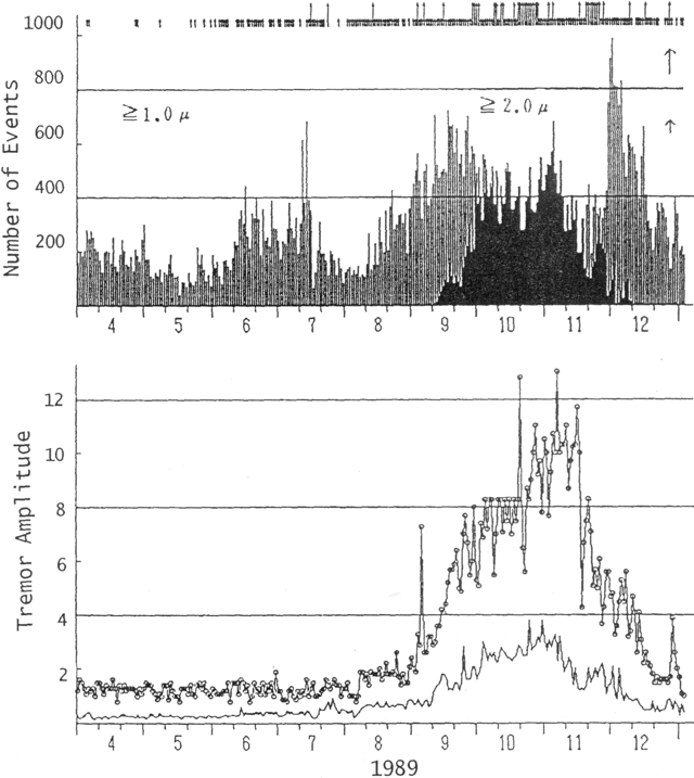 |
Figure 17. Daily number of isolated volcanic tremor episodes (top) and daily maximum and mean amplitudes of continuous tremor (bottom) at Aso, April-December 1989. Courtesy of JMA. |
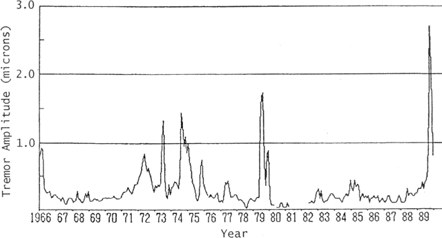 |
Figure 18. Monthly mean amplitude of continuous tremor at Aso, 1966-1989. Courtesy of JMA. |
Information Contacts: JMA.
Block and ash ejections increase in late January; daily ash emission in February
Activity was relatively quiet in the first half of January, but increased in the second half of the month. A 21 January explosion ejected blocks to 300 m above the crater rim. Additional explosions occurred at 1645 on 1 February and 1320 on 7 February, the latter continuously ejecting blocks to 300 m above the crater rim. Minor ash emission was observed almost daily, causing ashfalls around the crater. A total of 30 g/m2 of ash was deposited in January and 3,167 g/m2 in February at AWS. Volcanic tremor amplitude increased from the end of January, but declined toward the end of February.
A pool of water was present in Vent 892 during fieldwork on 15 February. Mud ejection was observed for the first time since September 1989. Vent 892 began to develop in October, and has gradually enlarged to occupy half of the crater floor.
Information Contacts: JMA.
Strong block and ash ejection after 2 months of quiet, then continuous ash emissions
A large eruption occurred on 20 April after 2 months of quiet. On 13 February, activity decreased to emission of white vapor and weak mud ejection from a water pool in [Vent 892]. Because of the decreased eruptive activity, the area within 1 km of the crater (closed since 9 August 1989) was reopened by the mayor of Aso town on 23 March.
At 1323 on 20 April, tremor amplitude suddenly increased by about five times. An "Extra Volcanic Information" was issued by the Aso town office and the tourist viewing area was closed by the mayor (both at 1415). Tremor amplitude abruptly decreased at 1644 and remained low until the eruption began, similar to several previous episodes. At the onset of the eruption at 1708, tremor amplitude again suddenly increased. Ash and block ejection was accompanied by a loud rumbling noise which was strongest at around 1730. Blocks 0.5 m across were ejected to 300 m above the crater rim throughout the eruption. The ash cloud rose more than 1 km, and three electrical discharges (lightning) were observed between 1808 and 1815. Tremor amplitude decreased at around 1815 and the eruption is believed to have ended shortly thereafter, although the exact timing is unknown.
Ash from the eruption, wet due to rain, fell mainly N of the volcano where it affected traffic and caused agricultural damage. The towns of Aso and Ichinomiya lost electricity at around 1800, presumably due to a short circuit or leak caused by the wet ash. Service was restored to most homes by midnight, although some had no power until noon the next day.
The eruption deposited 1 m of ash on the crater rim, 0.5 m of ash 1 km N of the crater, and 4 kg/m2 at 6 km N of the crater. Fine ashfall was observed to 35 km W (at Kumamoto) and 35 km E (at Takeda). Blocks, mostly dense and angular, and fresh scoria fell N of the volcano. Lithic clasts 20 cm in diameter were scattered to 1 km N. The total tephra mass from the 20 April activity was estimated to be 1 x 10⁹ kg (the total accumulated tephra mass from July 1989 through 20 April 1990 was 6 x 10⁹ kg; table 5).
Table 5. Number of days/month on which ash was emitted at Aso and monthly ash accumulation measured by JMA at AWS, 1 km W of the crater, July 1989-May 1990. The April 1990 value is low, despite the large emission on 20 April, because of wind direction.
| Date | Eruption days | Ash accumulation (g/m2) |
| Jul 1989 | 2 | 36 |
| Aug 1989 | 1 | 579 |
| Sep 1989 | 5 | 2,740 |
| Oct 1989 | 17 | 29,177 |
| Nov 1989 | 11 | 1,509 |
| Dec 1989 | 3 | 755 |
| Jan 1990 | 1 | 30 |
| Feb 1990 | 2 | 3,168 |
| Mar 1990 | 0 | 0 |
| Apr 1990 | 2 | 95 |
| May 1990 | 9 | 12,837 |
Ash emission was almost continuous from the morning of 21 April through early June. Another vigorous eruptive episode occurred 27 April and such episodes became frequent at the end of May. Tremor remained at low amplitude for a few days following the 20 April eruption then gradually increased to high amplitudes in May.
Information Contacts: JMA.
Ash and block ejection; gradual increase then abrupt decrease in tremor amplitude
Intermittent eruptive activity has continued since 16 July 1989 from Crater 1. Eruptive episodes on 3, 5, 6, 7, 12, 13, and 18 June ejected ash clouds and blocks and were similar to those of previous months. Ash ejection was most active on 13 June, as tephra rose continuously to ~1,000 m throughout the day and the month's highest ash cloud rose 3,000 m above the crater. The 18 June activity was also strong, ejecting blocks 300 m W from the center of the crater. Ash accumulation at AWS . . . was 9,713 g/m2 in June, slightly lower than the May total of 12,837 g/m2 that was the heaviest monthly ashfall since October 1989.
Tremor amplitude gradually increased through the end of June after the abrupt drop that followed a larger eruption on 20 April. Short-period and large tremors recorded between 22 June and 1 July were thought to have been generated by small phreatic explosions. The bottom of the crater was occupied by a water pool after heavy rains 14-16 June and 26 June-4 July. Tremor amplitude was very small 1-9 July. AWS issued an "Extra Volcanic Information" on 4 July, warning of the potential for a sudden explosion following the abrupt decrease in tremor amplitude.
Information Contacts: JMA.
Sporadic eruptive activity stops; variable tremor amplitude
. . . Ash clouds and blocks were ejected [from Crater 1] on 7 days in June 1990, most recently on the 18th. However, no eruptions occurred in July. Tremor amplitude increased from 22 June to 2 July, decreased, then gradually increased for the remainder of the month. The bottom of Crater 1 was covered with a pool of water.
Information Contacts: JMA.
Mud, water, and steam ejected from lake in active vent
Vent 892 on the NE floor of Crater 1 had been covered by a pool of water since the last noted ash ejection in the crater on 30 June. Frequent mud and water ejections, and white steam emissions occurred during July and August. A plume containing small amounts of ash, intermittently ejected to 100 m from a vent in the SW part of Crater 1, was noted along with strong rumbling during a visit 30 August. The number of tremor episodes gradually decreased toward the end of August and tremor amplitude was at low levels.
Information Contacts: JMA.
Scoria ejected from new vent
White steam emission from Crater 1 continued, punctuated by weak ash emissions on 1, 14, 16, 17, and 27 September. Plume heights ranged from a few hundred to 1,000 m above the crater. Vent 892, site of activity until June, was buried by mud and heavy rainfall in July. A visit to the crater on 17 September revealed the existence of a new vent (901), not visible the previous day, which ejected blocks and flame to 10 m. Scoria blocks were ejected to 30 m above the vent on 28 September, the first magmatic ejecta since 18 June (15:06). The amplitude and number of tremor episodes increased for several days around 20 September.
Information Contacts: JMA.
Weak ash emission and glow; increased tremor
No ash was erupted during October . . . . Crater 1 . . . continued to emit white steam that rose to 900 m above the crater. Weak ash emission was observed on 13 November, and glow from vents on the crater bottom was seen during fieldwork that night. The amplitude and number of volcanic tremor episodes increased in late October, reaching levels similar to September's and continuing at those levels through early November.
Information Contacts: JMA.
Tephra ejection resumes
Crater 1, active July 1989-June 1990 (table 6), weakly emitted ash on 12, 18-19, and 25-29 November; white steam was emitted steadily on other days. The highest plume observed in November reached 1,000 m above the crater. Ash had last been emitted on 17 September. The area within 1 km of the crater, which had reopened to tourists on 15 October, was closed on 12 November and remained closed in early December.
Table 6. Brief chronology of activity at Aso, January-14 December, 1990.
| Date | Activity |
| Jan 1990 | Eruption continuing (since July 1989). |
| 07 Feb 1990 | Eruption ceased. |
| Mar 1990 | Quiet, but white steaming continued. |
| 20 Apr 1990 | Eruption resumed. |
| May-Jun 1990 | Frequent strong eruptions. |
| Jul-Aug 1990 | Quiet, with occasional weak ash emissions. |
| Sep 1990 | Occasional ash emissions; vent 901 opened. |
| Oct 1990 | Quiet; white steam; tremor increased toward month's end. |
| Nov 1990 | Ash emissions and glow resumed at mid-month. Stronger tremor continued through the month. |
| 13 Nov 1990 | Glow resumed on crater floor. |
| 17 Nov 1990 | Scoria ejection resumed. |
| 24 Nov 1990 | Vent 902 had opened; 811°C temperature measured. |
| 04 Dec 1990 | Eruption at 0410 ejected 1,200-m ash cloud. |
| 06 Dec 1990 | Eruption; vent 903 had opened. |
| 07 Dec 1990 | Eruption. |
| 08 Dec 1990 | Eruption. |
| 13 Dec 1990 | Eruption. |
Glow from many points on the crater floor was observed during a night visit on 13 November, the first crater glow seen since June. Glow remained visible through early December. During 17 November fieldwork, incandescent scoria was being ejected to 30 m height from a small vent on the crater floor. Scoria ejection had last been observed in June. By the 24 November crater visit, a vent 10 m across had developed on the crater floor and was ejecting blocks to 5 m height. The vent was named 902, the second new vent of 1990.... An infrared thermometer detected a maximum temperature of 811°C in the vent.
Ash emission became frequent in early December. An eruption on 4 December at 1410 ejected a 1200-m ash cloud, December's highest (as of the 14th), and similar activity occurred on 6, 7, 8, and 13 December. Vigorous ash emissions had last occurred in June. Ejections of blocks and scoria were also more frequent and higher (to 150 m) in early December. A visit on 6 December revealed that a new vent... had opened near 902.
The amplitude and number of volcanic tremor episodes has gradually increased since October and remained high through November (figure 19).
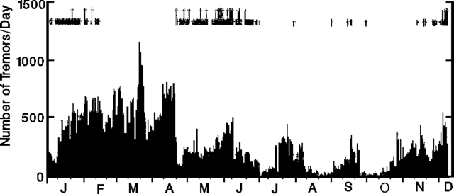 |
Figure 19. Daily number of tremor events at Aso, January-8 December 1990. Longer arrows at top of figure mark eruptions, shorter arrows indicate weaker ash emissions. Courtesy of JMA. |
Information Contacts: JMA.
Periodic tephra emissions from new vent
Steam and ash were emitted periodically throughout December, to a maximum height of 1,200 m, on 4 December. A crater visit on 6 December revealed a new vent (903), 30 m long and 10 m wide. The center of eruptive activity had moved to Vent 903 from Vent 902 . . . . The amplitude and number of tremor episodes had gradually increased since October, and remained high through early January 1991.
Information Contacts: JMA.
Frequent ash emission, but tremor declines
Crater 1 emitted ash on 8-9, 18, 20-21, 23, and 28-29 January. The highest cloud observed in January reached 700 m above the crater on the 29th. Continuous tremor amplitude, which had been high since October, declined toward the end of January.
Information Contacts: JMA.
Tremor amplitude and steam emission decline
Crater 1 weakly emitted ash on 5, 8, and 9 February, and steadily emitted steam to 100-200 m heights on other days, a decline from previous months. The highest steam emission of the month reached 300 m above the crater on the 7th. Continuous tremor amplitude, which had been high since October, has declined since the end of January. Activity continued at similar levels through early March.
Information Contacts: JMA.
Mud/water ejections from heating crater lake; tremor episodes
Isolated volcanic tremor episodes began to increase in October 1991, reaching about 100 events/day by the end of May. The increase in seismic activity followed a period of quiet after the July 1989-December 1990 eruptive phase. Ejections of mud and water, the first since June 1991, were observed within the active crater lake . . . on 23 April. Similar ejections, to 5 m height, were observed on 27 April, 1 and 27 May, and 2 June. The lake's surface temperature has been increasing since March-May 1991 when it was 20-30°C, reaching ~70°C (measured by infrared thermometer) in May. Weak mud ejections have been common in the past, during the period between eruptive phases when the crater is normally occupied by a lake, but have not been observed during the lowest levels of activity.
Information Contacts: JMA.
Explosions follow increased seismicity and heating of crater lake
Eruptions that occurred from Crater 1 during the night of 30 June-1 July were the first [strong explosions] since . . . December 1990. The daily number of isolated volcanic tremor episodes began to increase in October 1991, and had reached ~100/day by the end of May. Isolated tremor episodes rapidly became more frequent in late June, and the amplitude of continuous tremor also increased through the month.
Ejections of mud and water from the lake in Crater 1 were first noted on 23 April and were sporadically observed later in April and in May. The ejections became more vigorous in late June, increasing in height from 5 m on 24 June to 20 m on the 26th, 50 m on the 29th, and 150 m on the 30th. Surface temperatures of the lake water increased from around 20°C in May 1991 to 78°C in June 1992. Steam plumes also grew to 1,000 m height in late June.
Strong tremor episodes were recorded during the night of 30 June-1 July. During fieldwork at noon on 1 July, the crater was quiet, but many blocks to 0.8 m across had been scattered to 100 m from the crater's NE rim. The eruptions were not seen or heard, but seismic and air-vibration records suggested that they may have occurred at 2349 on 30 June and 0316 on 1 July.
Tremor decreased in early July, but remained at higher levels than in mid-June. Ejections of mud and water to heights of a few tens of meters occurred sporadically through early July, but no additional strong mud/water ejections or eruptions were reported.
Because of the increasing activity, the area within 1 km of the crater was closed to tourists on 24 June, and remained closed as of mid-July.
Information Contacts: JMA.
Phreatic activity and seismicity decline after block ejection
Blocks were ejected during the night of 30 June-1 July from Crater 1 for the first time since... December 1990. Vigorous steam emission followed for about 10 days, fed a plume to a maximum of 2 km height on 6 and 8 July, then gradually declined toward the end of the month (figure 20). Ejections of water, mud, and blocks that rose ~50 m above the surface of the crater lake were observed almost every day during July. The lake shrank rapidly in early July until it occupied only about 1/3 of the crater floor. The temperature of the lake surface (measured by infrared thermometer) reached 95°C on 4 July (figure 19), the highest since March 1991, but declined to around 60° by the end of the month. Isolated tremor episodes, which had peaked at ~2,000/day at the end of June, declined rapidly after the block ejection to 0-6/day (figure 20). The amplitude of post-eruption continuous tremor also declined (figure 21).
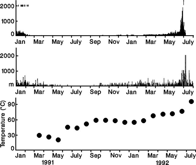 |
Figure 20. Daily number of tremor episodes (top), steam cloud heights (middle), and highest monthly surface temperatures of the crater lake (bottom) at Aso, January 1991-July 1992. A long arrow marks the 30 June-1 July eruption. Smaller arrows show weaker ash emissions. Courtesy of JMA. |
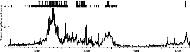 |
Figure 21. Daily mean amplitude of continuous tremor at Aso, late 1988-July 1992. Long arrows mark strong explosions, short arrows indicate weak ash emissions. Courtesy of JMA. |
Similar activity continued through mid-August, with weak mud ejections from the lake, steady steam emissions to 1,000 m height, and low-level seismicity. The lake expanded again to cover all of the crater floor by 5 August because of inflow of groundwater, precipitation, and weaker ejection activity.
The area within 1 km of the crater . . . was reopened on 10 August.
Information Contacts: JMA.
Explosion ejects blocks
Heavy rains expanded the crater lake in early August but it shrank to cover only 20% of the crater floor later in the month as a result of daily ejections of mud, blocks, and water. Steam emissions were continuous, rising to 1 km on 10 and 24 August.
A strong eruption of water, blocks, and mud from Crater 1 at 1223 on 8 September ejected blocks to 200 m above the crater rim and a 2-km steam plume. Blocks up to 70 cm across were scattered to 300 m W of the crater rim. The eruption was similar in size to the previous eruption on 30 June-1 July, but eruption tremor of 30 µm amplitude was detected by a seismometer 800 m W of the crater, compared to the 9-µm amplitude recorded by the same instrument on 1 July. No changes in tremor activity were recorded before the eruption, although there was an increase in the amplitude of continuous tremor for two days after the eruption (figure 22). There were only 55 isolated tremor episodes in August compared to 1520 in July, with another 35 events recorded in September through the 15th.
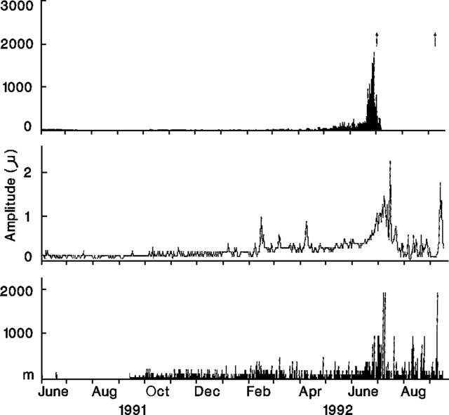 |
Figure 22. Daily number of isolated volcanic tremor episodes (top), daily mean amplitude of continuous tremor (middle), and plume heights (bottom) at Aso, 1 June 1991-15 September 1992. Arrows mark explosive episodes. Courtesy of JMA. |
Information Contacts: JMA.
Blocks ejected by explosive episode
An eruption from Crater 1 ejected blocks at 1223 on 8 September, the first such activity since a similar episode on 30 June-1 July. Another eruption at 1627 on 29 September scattered blocks 800 m SE and ejected a steam plume 2,000 m high. The number of blocks and the distance they fell from the crater were greater than for the eruptions of 8 September and 1 July. Eruption-tremor amplitude was 30.2 and 30.4 µm, respectively, for the September eruptive pisodes.
Steam was steadily emitted to a few hundred meters throughout September, and volcanic-tremor frequency was low. No anomalies in steam emission or tremor frequency were noted either before or after the eruptions. However, continuous-tremor amplitude increased for two days after the 8 September eruption. Weak ejections of mud, blocks, and water continued.
An area within 1 km of the crater has been closed to tourists since 24 August, and no damage was caused by the eruptions. Similar activity has continued through 14 October, but there have been no additional eruptions.
Information Contacts: JMA.
Explosion produces 2500-m plume and wet ashfall; weak ejections from crater lake
An eruption from Crater 1 occurred at 1340 on 26 October, the fourth this year and the first such activity since 29 September. A steam plume containing ash rose 2,500 m, and wet ash fell 1.5 km S of the crater. No blocks were jected. Eruption-tremor amplitude was 20 µm at the nearest seismometer, 0.8 km W of the crater (table 7).
Table 7. Eruptions at Aso during 1992. Courtesy of JMA.
| Date | Tremor Amplitude | Plume Height | Range of blocks (from center of crater) |
| 01 Jul 1992 | 9 µm | unknown | 300 m N |
| 08 Sep 1992 | 30 µm | 2 km | 600 m E |
| 29 Sep 1992 | 30 µm | 2 km | 700 m S |
| 26 Oct 1992 | 20 µm | 2.5 km | none |
Steam was steadily emitted to a few hundred meters throughout October, and volcanic-tremor frequency was low. No changes in steam emission, tremor frequency, or earthquakes were noted before or after the eruption. Weak ejections of mud, blocks, and water to 15 m height continued in the crater lake, which ccupies half of the crater floor. Similar activity has continued through 14 November, without additional eruptions. The area within 1 km of the crater has been closed to tourists since 24 August. No damage was caused by the eruption.
Information Contacts: JMA.
Renewed block ejection; gas plume
No eruptions have been observed since a brief episode on 26 October from Crater 1. Ejections of mud, blocks, and water to 30 m height continued n the crater lake through November. Steam was steadily emitted to 500 m, reaching 1 km on 27 November (figure 23). Volcanic tremor and earthquake activity ere low. The area within 1 km of the crater... was re-opened on 12 November.
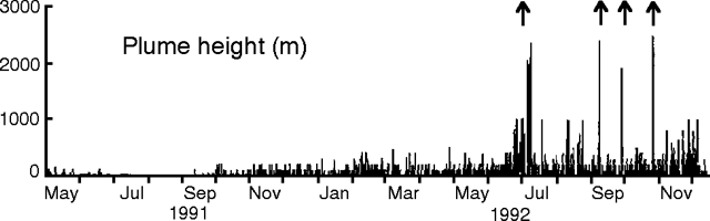 |
Figure 23. Steam-plume heights from Aso, May 1991-13 December 1992. Arrows mark explosive episodes. Courtesy of JMA. |
Surface activity increased in December. Continuous low rumblings were heard beginning on 1 December, and on the 3rd, blocks were ejected to 200 m from the crater floor. An area of 1-km radius was again closed at 1400 on 3 December. Observations the following day revealed that a new vent (named 921) about 5 m across had developed in the central part of the crater floor, producing flames 10 m high and ejecting incandescent blocks to 5 m height. The ejections continued the next day, but activity was unconfirmed after 6 December. The continuous steam plume included minor ash 4-7 December but was white again on the 8th. The highest steam plume rose 1 km on 5 December but the plume was only a few hundred meters high after the 6th. Seismicity was relatively low, unchanged from November.
Information Contacts: JMA.
Mud/water ejection from crater lake; steam plumes; new vent
No eruptions have been observed since . . . 26 October . . . . Ejections of mud and water to 20 m height continued in the crater lake through December. Steam was steadily emitted to 500 m, reaching 1,000 m on 5 December. The steam plume contained minor ash 4-7 and 26-27 December. [Vent 921] emitted ash until 7 December, then became inactive and was no longer visible a few days later. Observations on 26 December, following an increase in rumbling the previous day, revealed that a new vent (named 922) about 30 m across had developed near the site of Vent 921, and was emitting ash and steam. Seismicity was relatively low, with tremor amplitude gradually increasing after the middle of the month. The area within 1 km of the crater, closed to the public on 3 December, was reopened on the 30th.
Information Contacts: JMA.
Block ejection and steam emission; seismicity remains high
Field reports confirmed that by 1 January the lake in Crater 1 had dried up. Steam was steadily emitted to ~500 m, with the plume containing ash 13-14 and 17-29 January. A small eruption occurred in the crater on 21 and 22 January, ejecting many scoria blocks to 10-50 m heights from Vent 922. This was the first eruption since 26 October and the first scoria eruption since June 1992. . . . Ejecta fell within the crater, which is 400 m across and 150 m deep. The steam plume, containing ash, rose 1,000 m on the 21st and 1,500 m the 22nd. Seismicity has been relatively high since mid-December, but no significant change was detected before or after the eruption.
Activity continued at the same levels through early February, with steam emission to a few hundred meters, occasionally containing ash.
Information Contacts: JMA.
Scoria eruption; seismicity declines
The eruptive phase... continued through February at Crater 1. At noon on 20 February, vent 922 ejected scoriae to 100 m above the vent, the first eruption observed during daily visits to the crater rim since 22 January. The ejecta, consisting of blocks up to 50 cm across, fell within the 400-m-wide, 150-m-deep crater. Incandescent fountaining, also to a height of 100 m, was observed that night. Inclement weather prevented visual observations in the following days and the ending date for the eruption is not known.
The amplitude of the continuous tremor, which increased in late December, persisted at an elevated level until 10 February, when it rapidly declined (figure 24). The decline was not accompanied by any observed change in surface phenomena. At 0600 on 20 February, the tremor amplitude increased. Tremor amplitude remained high during and after the eruption, abruptly returning to background level at 1215 on 25 February after a small block ejection. An area within 1 km of the crater has been closed since 18 January.
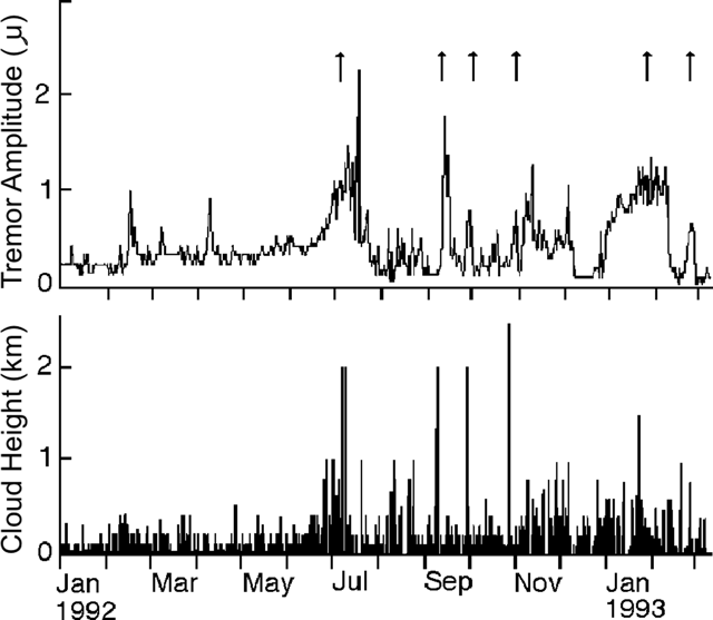 |
Figure 24. Daily mean amplitude of volcanic tremor (top) and height of steam plume (bottom) at Aso from 1 January 1992 to 8 March 1993. Arrows at the top indicate eruptions. Courtesy of JMA. |
Ash was observed in the steam plume on 1-5, 12-13, 18-20, and 23-25 February. The plume rose to heights of 500 m, increasing briefly to 1,000 m n 19-20 February (figure 24).
Information Contacts: JMA.
Activity decreases; crater lake forms
Activity in March and early April was lower than in previous months. Rain created a small lake in part of Crater 1. On roughly half of the March visits, mud and blocks were seen being ejected a few meters above the lake. A white steam plume continually rose 200-500 m; it contained a minor amount of ash on 7 March. Seismic activity was low.
Information Contacts: JMA.
Mud ejected; tremor amplitude increases
Activity at [Crater 1] has been moderate since an explosion on 20 February 1993 ejected scoriae 100 m above the vent. During the daily rim visit on 2 May 1994, mud ejection was observed for the first time since 10 June 1993. However, the crater floor has been covered by water and frequent water ejections have been observed. Continuous tremor was registered at a seismic station 800 m W of the crater. Average amplitude of continuous tremor had been 0.2 µm through May, but on 7-9 June the average amplitude suddenly increased to >6 µm.
Information Contacts: JMA.
Volcanic tremor; water ejections from pond in crater floor
Crater 1 remained restless through June after a mud ejection on 2 May. The floor of the crater has been covered by a pool of water, but frequent water ejections have been noted during daily observations from the crater rim. Continuous tremor was registered at the seismic station 800 m W of the crater. During May, average tremor amplitude was around 0.2 µm. However, in early June, the amplitude increased suddenly. Continuous tremor became intermittent from 7 to 21 June, and isolated tremor occurred with a maximum amplitude >6 µm.
Information Contacts: JMA.
Crater 1 at Nakadake still restless
Crater 1 remained restless through July, but the intensity of activity became more moderate compared to the last two months. Through July the average amplitude of continuous tremor was around 0.1 µm.
Information Contacts: JMA.
Mud and stone ejections from crater floor
Activity from Crater 1 was moderate in August. However, at about 0800 on 11 September, intermittent mud ejection from the water-covered crater floor was detected seismically. Tremor registered at a station 800 m W of the crater had an amplitude of 4.8 µm. The seismic station detected similar activity on the evening of 12 September. During the daily crater visit on the morning of 14 September, several tens of stones were found outside the crater rim, within ~300 m of the crater center.
Information Contacts: JMA.
Explosions eject mud and blocks
Activity increased at Crater 1 during September. Tremor amplitude registered at a seismic station 800 m W of the crater was 4.8 µm at about 0800 on 11 September. Three hours later, the AWS (figure 25), issued a Volcanic Advisory noting that Aso was getting restless. Another tremor, which was large enough to be felt at AWS, occurred at 1148 later that day. The floor of Crater 1 was covered by a pool of water, and intermittent mud ejection took place. Several tens of volcanic stones were found outside of the crater rim within ~300 m from the center of the crater during a visit on the morning of 14 September. These rocks were ejected by an explosion on the evening of 12 September, based on seismic records. The area within 1 km of Crater 1 was placed off-limits on 11 September by local governments through the Board for Volcanic Disaster Reduction.
 |
Figure 25. Summit area of Nakadake cone at Aso, showing numbered craters, the Aso Weather Station, and associated buildings (squares). Courtesy of JMA. |
During the rest of September, mud ejection was intermittent and volcanic tremor was frequent. On 15 and 18 September, ejected mud rose 150 m above the bottom of the crater, almost to the crater rim. On 16 and 19 September, a plume rose to a height of 1,500 m above the crater rim. Tremor was felt by personnel at AWS on 11, 15, 21, 22, and 29 September, and 1 October. The 29 September event was registered 800 m W of the crater with an amplitude of 52 µm, which is the largest reading since tremor amplitude measurements began in 1969.
The 12 September ejection of stones beyond the crater rim was the first eruptive activity since February 1993; mud ejections have been reported since 2 May 1994.
Information Contacts: JMA.
Continued mud ejections and ash plumes from Nakadake crater 1
After ejecting mud and blocks on 12 September, Crater 1 remained restless in October (figure 26). The water-covered crater floor ejected mud intermittently, sometimes accompanied by ash plumes. In one case on 27 October, ejected mud flew more than 100 m above the crater bottom. Tremor amplitude (at Station A, 800 m W of the crater) generally remained less than 1 µm. Some larger tremor episodes exceeded 10 µm and were felt by personnel at the Aso Weather Station.
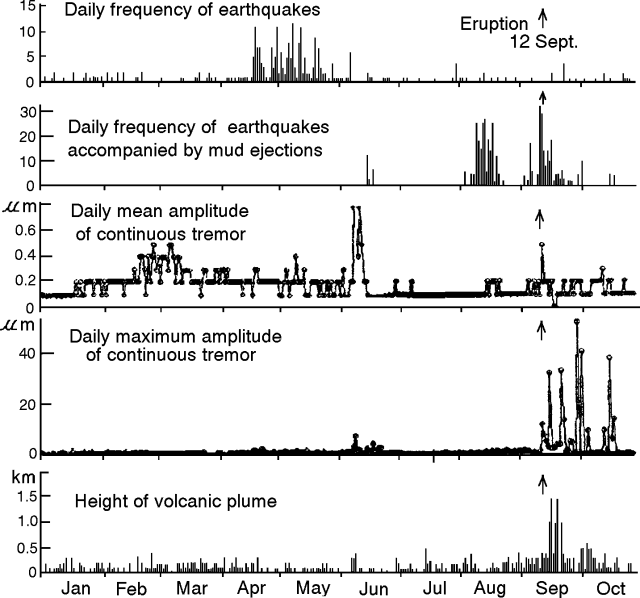 |
Figure 26. Seismicity and plume heights at Aso, January-October 1994. Earthquakes and tremor were registered at a station 0.8 km W of Nakadake cone. Plume heights were estimated by personnel at AWS. Courtesy of JMA. |
Information Contacts: JMA.
Minor phreatic activity from crater lake
During November, no eruptive activity took place at Crater 1. Water and gas ejection from a pool of water on the crater floor was observed on 5 days in November (specifically, 2, 3, 6, 27 and 28 November). Tremor amplitude registered at a seismic station 800 m W of the crater was not greater than 0.5 µm, but in December the amplitude began to rise.
Information Contacts: JMA.
Intermittent mud ejection and large-amplitude tremor
Intermittent mud ejection from the pool of water on the floor of Crater 1 continued in December. Ejections on 18 and 23 December rose 150 m, almost to the level of the crater rim. Large-amplitude tremor was often registered, and 12 seismic events were felt at the AWS.
Information Contacts: JMA.
More mud ejections, tremor, and a white plume
Intermittent mud ejections from the lake in Crater 1 continued through mid-January. Mud ejections that rose 100 m on 2 January were accompanied by tremor, seven seismic events felt at the AWS, and a white plume rising to 2 km above the crater rim. At other times during January a white plume rose continuously to ~400 m above the crater rim from the water-covered crater floor, ~150 m below the rim. Large-amplitude tremor associated with the mud ejections was often registered, and one other event was felt on 4 January.
Information Contacts: JMA.
Mud ejection beyond the crater and an ash cloud to 1 km
Mud and water ejections continued during February from the shrinking pool of hot water in Naka-dake Crater 1. Similar ejections occurred on 13 and 17 March. The eruption on 17 March ejected mud and volcaniclastic materials within a 300-m radius, including some beyond the crater rim, and sent an ash cloud as high as 1 km above the crater rim. Large-amplitude tremor associated with the mud ejections was felt at the Aso Weather Station (AWS) on 14 and 19 February, and another nine times during March. An earthquake centered beneath the crater was also felt at AWS on 16 February.
Information Contacts: JMA.
Mud and water ejections from crater lake; tremor
During April and May, occasional water ejections took place from a hot water pool at the bottom of Naka-dake Crater 1. Water volume in the pool had decreased by 60% in late May. On 9 April mud and water ejections were observed at the bottom of the crater, in addition to a large-amplitude tremor felt at the Aso Weather Station. The daily number of isolated (short-duration) tremors increased in the middle of April, and during May a total of 1,128 were recorded from Station A, 800 m W of Crater 1.
Information Contacts: Volcanological Division, Seismological and Volcanological Department, Japan Meteorological Agency (JMA), 1-3-4 Ote-machi, Chiyoda-ku, Tokyo 100 Japan.
Water rises and covers the crater floor, minor water and mud ejections
During June, occasional water ejections took place from a hot water pool at the bottom of Naka-dake Crater 1. The volume of water in the crater increased towards the end of June such that by July Naka-dake's crater was completely covered with hot water. During July, the occasional water ejections were accompanied by the ejection of mud, the highest reaching 10 m.
In July, 791 isolated tremors were recorded at Station A, 800 m W of Crater 1. Continuous tremor occurred through early July, with a maximum amplitude of 8 µm. There were seven natural tremors during July, including four felt at the Aso Weather Station and three earthquakes. Only one large-amplitude tremor was recorded during June.
Information Contacts: Volcanological Division, Seismological and Volcanological Department, Japan Meteorological Agency (JMA), 1-3-4 Ote-machi, Chiyoda-ku, Tokyo 100 Japan.
Continued mud and water ejections; increasing tremor episodes
The bottom of Naka-dake Crater 1 remained covered with a pool of hot water throughout August. The central part of the lake was gray, changing to grayish white or green near the margins. Mud and water ejections were frequently observed; the highest rose 10 m. Isolated tremors increased late in the month (recorded 800 m W of the crater). Isolated tremor events totalled 2,613 during August, and five earthquakes were detected. Tremor events continued increasing in early September; by the 10th there had been >2,000 counted.
Information Contacts: Volcanological Division, Seismological and Volcanological Department, Japan Meteorological Agency (JMA), 1-3-4 Ote-machi, Chiyoda-ku, Tokyo 100 Japan.
Continued mud and water ejections and many isolated tremors
Throughout September the hot water pool on the floor of Naka-dake Crater 1 frequently ejected mud and water; the highest ejection rose 10 m. Many isolated tremors were recorded at Station A, 800 m W of the crater. The monthly total of isolated tremors was 6,618; only two earthquakes were detected. Continuous tremor with 0.2-0.8 µm amplitude was registered throughout the month.
Mud ejections have been reported since May 1994 (BGVN 19:05). The 24-km-wide Aso Caldera contains 15 central cones. One of these cones, Naka-dake, has erupted more than 165 times since 553 AD, the first documented historical eruption in Japan. Aso is located 75 km E of Unzen and 150 km N of Sakura-jima volcanoes.
Information Contacts: Volcanological Division, Seismological and Volcanological Department, Japan Meteorological Agency (JMA), 1-3-4 Ote-machi, Chiyoda-ku, Tokyo 100 Japan.
Isolated tremor; ejections of mud and water
During October the floor of Aso's active crater (Naka-dake Crater 1) remained covered by a pond of hot water. The pond's surface was disrupted by occasional fountaining up to 5-m high. Elevated tremor continued since last month, and some October days had over 200 earthquakes; the daily mean amplitude of continuous tremors sometimes reached over 0.5 þm. Personnel 800 m W of the crater (at Aso Weather Station) felt earthquakes at 1829 and 1909 on 11 and 22 October, respectively.
Information Contacts: Volcanological Division, Seismological and Volcanological Department, Japan Meteorological Agency (JMA), 1-3-4 Ote-machi, Chiyoda-ku, Tokyo 100 Japan.
Numerous isolated tremors
During November and December 1995 the floor of Naka-dake Crater 1 remained covered with hot water, yet there were few if any mud-and-water ejections. During November the number of isolated tremors reached 5,488; during December, 4,896. In addition, continuous tremor prevailed with amplitudes confined to 0.1-0.8 µm.
Information Contacts: Volcanological Division, Seismological and Volcanological Department, Japan Meteorological Agency (JMA), 1-3-4 Ote-machi, Chiyoda-ku, Tokyo 100 Japan.
Continuous tremor; crater floor still covered with water
The floor of Naka-dake Crater 1 remained covered with water in January. Seismic station A, 800 m W of the crater, recorded continuous tremor of 0.1-0.3 µm amplitude. In addition, there were 4,966 isolated tremors during the month.
Aso, a 24-km-wide caldera, produced pyroclastic-flow deposits during the Pleistocene that cover much of Kyushu. Its frequently active Naka-dake is one of a group of 15 intra-caldera cones.
Information Contacts: Japan Meteorological Agency (JMA), Volcanological Division, Seismological and Volcanological Department, 1-3-4 Ote-machi, Chiyoda-ku, Tokyo 100, Japan.
Crater glow
Red glow has been observed over part of the S wall of Naka-dake Crater 1 since 27 April. The floor of this crater was still covered with water in May. Aso, a 24-km wide caldera, produced pyroclastic-flow deposits during the Pleistocene that cover much of Kyushu. Naka-dake, one of the 15 intra-caldera cones of Aso's caldera, has erupted more than 165 times since 553 AD.
Information Contacts: Japan Meteorological Agency (JMA), Volcanological Division, Seismological and Volcanological Department, 1-3-4 Ote-machi, Chiyoda-ku, Tokyo 100, Japan.
Crater glows; water and mud ejected
Red glows were observed over the S wall of Naka-dake Crater 1 in May and June. The crater floor was covered with water in June, and weak water ejections were observed on 5-6 June. On 30 July, Crater 1 ejected mud on its SE side. Such ejections were also observed on 26 October 1995 (BGVN 20:10).
The 24-km-wide Aso Caldera contains 15 central cones. One of these cones, Naka-dake, has erupted more than 165 times since 553 A.D.
Information Contacts: Volcanological Division, Japan Meteorological Agency, 1-3-4 Ote-machi, Chiyoda-ku, Tokyo 100, Japan
Two tourists killed by volcanic gas on 23 November
Tomoki Tsutsui (Aso Volcanological Laboratory, Kyoto University) reported that a new fumarolic vent ~10 m in diameter formed on the S wall of Crater 1 in early November; later, small mounds of mud formed around the vent. Although Crater 1 had been quiet since 1993, hot greenish-gray water remained in the crater. Videos of Crater 1 taken by the Aso Volcano Museum recorded emissions of mud fragments and white fumes from the new vent, as well as a bubbling noise; other instruments detected low-level volcanic tremors.
According to news reports, inhalation of volcanic gas killed two men, aged 62 and 51 years, after they collapsed ~100 m S of Crater 1's rim at 0945 and 1040 on 23 November. Volcanic gas concentration around the crater is monitored using a sensor installed by the Japan Meteorological Agency in April 1997. Due to high levels of SO2 (~5 ppm), the Crater 1 overlook was closed on the morning of 23 November, but re-opened at 0900 when the SO2 level dropped to2 levels rose to ~8 ppm. The weather station at Aso had recorded no abnormal volcanic conditions.
Seventy-one people have been hospitalized due to inhalation of volcanic gases at Aso since 1980; of those, seven were killed. In June 1994, five junior high school students on a field trip collapsed near Crater 1.
Aso, a 24-km wide caldera, produced Pleistocene pyroclastic-flow deposits that cover much of Kyushu. Fifteen central cones form an E-W line on the caldera floor. Naka-dake, one of the intra-caldera cones, has erupted more than 165 times since 553 AD. Naka-dake has a group of craters (1.1 km long) including Crater 1 at the summit. Strombolian, phreatic, and phreatomagmatic eruptions are common in Crater 1. The 4 km2 100-m-deep Crater 1 is accessible by cable car, automobile, and on foot.
Information Contacts: Tomoki Tsutsui, Aso Volcanological Laboratory, Kyoto University, Choyo, Aso, Kumamoto, 869-1404, Japan; Volcano Research Center, Earthquake Research Institute (ERI), University of Tokyo, Yayoi 1-1-1, Bunkyo-ku, Tokyo 113, Japan (URL: http://www.eri.u-tokyo.ac.jp/VRC/index_E.html).
Phreatic eruptions during 10-14 July cause ashfall 14 km away
Recent noteworthy activity at Aso consisted of elevated tremor in August 2002 and a phreatic eruption in July 2003. Seismicity recorded by the Japan Meteorological Agency (JMA) between January 2000 and April 2003 (table 8) was generally constant, with continuous volcanic tremor every month in addition to isolated tremor events. The number of tremor events was high through October 2000, during April 2002, and from August 2002 through March 2003. Also during this extended period, white plumes were observed approximately once a month, with two or more plumes occurring in July, October, and December 2002, and February and March 2003. These plumes were usually less than 500 m high.
Table 8. Seismicity at Aso between January 2000 and April 2003. The seismograph station is located ~13 km W of the summit. Courtesy of JMA.
| Month | Number of volcanic earthquakes | Number of volcanic tremors |
| Jan 2000 | 19 | 1,466 |
| Feb 2000 | 16 | 926 |
| Mar 2000 | 73 | 1,232 |
| Apr 2000 | -- | -- |
| May 2000 | 39 | 537 |
| Jun 2000 | 30 | 802 |
| Jul 2000 | 29 | 1,234 |
| Aug 2000 | 21 | 2,104 |
| Sep 2000 | 36 | 1,445 |
| Oct 2000 | 38 | 1,448 |
| Nov 2000 | 43 | 202 |
| Dec 2000 | 33 | 129 |
| Jan 2001 | 51 | 60 |
| Feb 2001 | 161 | 739 |
| Mar 2001 | 76 | 537 |
| Apr 2001 | 40 | 81 |
| May 2001 | 40 | 85 |
| Jun 2001 | 99 | 188 |
| Jul 2001 | 84 | 282 |
| Aug 2001 | 60 | 471 |
| Sep 2001 | 40 | 86 |
| Oct 2001 | 91 | 32 |
| Nov 2001 | 52 | 17 |
| Dec 2001 | 45 | 5 |
| Jan 2002 | 38 | 5 |
| Feb 2002 | 59 | 20 |
| Mar 2002 | 20 | 20 |
| Apr 2002 | 114 | 1,138 |
| May 2002 | 91 | 14 |
| Jun 2002 | 191 | 36 |
| Jul 2002 | 238 | 37 |
| Aug 2002 | 153 | 4,413 |
| Sep 2002 | 144 | 1,438 |
| Oct 2002 | 103 | 1,440 |
| Nov 2002 | 652 | 3,391 |
| Dec 2002 | 154 | 8,496 |
| Jan 2003 | 122 | 6,981 |
| Feb 2003 | 178 | 4,183 |
| Mar 2003 | 92 | 1,965 |
| Apr 2003 | 70 | 474 |
Activity during August 2002. For the first time since 1992, isolated volcanic tremor events occurred at a rate of more than 300 events/day in Naka-dake Crater 1. These events were recorded between 5 and 21 August and totalled nearly 4,000 (table 9), with the highest number, 340 events, on 15 August. During this period, the water temperature of the pool in the crater remained between 57 and 60°C. On 14 August, infrared cameras measured the maximum temperature of the southern crater wall at 307°C; this increased to 314°C the following week.
Table 9. Daily number of isolated volcanic tremor events at Aso, August 2002. Courtesy of Japan Meteorological Agency.
| Date | Isolated tremor events |
| 05 Aug 2002 | 129 |
| 06 Aug 2002 | 238 |
| 07 Aug 2002 | 241 |
| 08 Aug 2002 | 137 |
| 09 Aug 2002 | 244 |
| 10 Aug 2002 | 304 |
| 11 Aug 2002 | 315 |
| 12 Aug 2002 | 335 |
| 13 Aug 2002 | 299 |
| 14 Aug 2002 | 336 |
| 15 Aug 2002 | 340 |
| 16 Aug 2002 | 287 |
| 17 Aug 2002 | 257 |
| 18 Aug 2002 | 208 |
| 19 Aug 2002 | 162 |
| 20 Aug 2002 | 104 |
| 21 Aug 2002 | 37 as of 1100 |
Activity during July 2003. JMA reported on 11 July 2003 that tephra had fallen at Aso that morning. According to the report, a tremor event with an intermediate amplitude was recorded at 1718 on 10 July. Staff from the Aso Weather Station confirmed that small amounts of tephra had been newly deposited at Hakoishi-Toge (Hakoishi Pass), ~ 6 km ENE of the Nakadake crater. Kazunori Watanabe (Kumamoto University) and other geologists surveyed the deposit on 11 July and estimated the total mass of ejected material at roughly 130 tons. Ash was deposited as far as 14 km from the crater. A small amount of fresh vesicular glass particles were noted in the ejecta under the microscope. According to Yasuaki Sudo (Aso Volcanological Laboratory, Kyoto University), who inspected the crater area, the event was a small phreatic eruption of mud. The deposit consisted of wet ash aggregates and was ~ 1 mm thick, even at the crater rim. A spray of mud was blown off the crater rim by strong winds to 10 km from the crater.
Seismic signals implied a series of small phreatic eruptions between 12 and 14 July. Then on 27 July continuous volcanic tremor started around 1400. Observations that day noted that the water in Crater 1 was gray and boiling in the center; the temperature of the water was 76°C.
Information Contacts: Volcanological Division, 1-3-4 Ote-machi, Chiyoda-ku, Tokyo 100, Japan (URL: http://www.jma.go.jp/); Volcano Research Center, Earthquake Research Institute (ERI), University of Tokyo, Yayoi 1-1-1, Bunkyo-ku, Tokyo 113, Japan (URL: http://www.eri.u-tokyo.ac.jp/VRC/index_E.html); Kazunori Watanabe, Kumamoto University, 40-1, Kurokami 2-chome, Kumamoto 860-8555, Japan; Hitoshi Yamasato and N. Uchida, Japan Meteorological Agency (JMA), Fukuoka District Meteorological Observatory, 1-2-36 Oohori, Chuo-ku, Fukuoka 810-0052, Japan; Tomoki Tsutsui and Yasuaki Sudo, Aso Volcanological Laboratory, Kyoto University, Choyo, Aso, Kumamoto, 869-1404, Japan.
June 2003 phreatic outbursts and a January 2004 mud eruption
Japan Meteorological Agency (JMA) reports for July 2003 noted ash-bearing eruptions from Aso (BGVN 28:10). The 10 or 11 July 2003 eruption was followed by seismically inferred phreatic eruptions a few days later, and a mud eruption on 14 January (the end of this report interval).
Seismic signals during 12-14 July implied there had been about five small phreatic eruptions. Continuous volcanic tremor started at ~ 1400 on 27 July. The JMA report of 28 July 2003 noted that seismometers had recorded ~ 100 isolated tremors. Earthquakes also occurred, at a rate of ~ 10 per day. On 28 July, lake water in Crater 1 was gray colored with a temperature of 76°C and with boiling regions in its central area.
A later JMA report noted a mud eruption in Crater 1 at 1541on 14 January, the first such eruption since July 2003. Associated tremor also occurred. Small amounts of very fine ash from this eruption were seen in Takamori, a town ~ 10 km ESE of the crater. The report noted that thermal activity had risen since last year, causing the water level in the crater to decrease about 40% below normal. The hazard status rose from 2 to 3, and accordingly, authorities restricted tourists from the area within 1 km of the crater.
Information Contacts: Volcanological Division, Japan Meteorological Agency (JMA), 1-3-4 Ote-machi, Chiyoda-ku, Tokyo 100, Japan (URL: http://www.jma.go.jp/); Fukuoka District Meteorological Observatory, Japan Meteorological Agency (JMA), 1-2-36 Oohori, Chuo-ku, Fukuoka 810-0052, Japan.
Small ash-bearing eruptions during May and to lesser extent in June 2011
After small ash-bearing eruptions, the Alert Level on Aso was raised from 1 to 2 (on a scale of 1-5) on 17 May 2011. Aso, the largest volcano in SW Japan, consists of a large, 24-km-diameter caldera located on the Japanese island of Kyushu (figure 27). Under normal conditions the area within the caldera is restricted and, with the raising of the Alert Level, authorities restricted entry within 1 km of Naka-dake cone, containing one of the active craters that comprise the Aso volcanic complex.
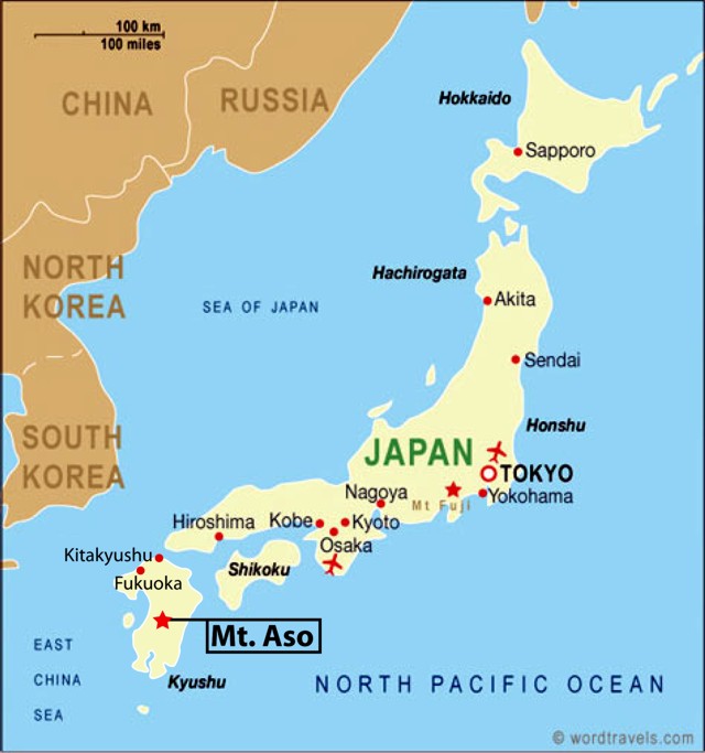 |
Figure 27. Map of the main islands of Japan; Mt. Aso is on the Island of Kyushu. Map from Wordtravels.com. |
Fumarole temperature from hydrogen isotopic ratios. The temperature of fumarole gas is a primary observation used at many volcanoes. Tsunogai and others (2011) describe a method of using hydrogen isotope ratios to determine fumarolic temperature. Because the isotopes can be collected at a distance from the vent and without entering the crater, this method offers several advantages. Aso was one of the volcanoes where this technique was applied because it has a deep crater that makes direct sampling and at-vent measurements impractical. Direct sampling of gases is potentially far more hazardous. Infrared measurements may suffer bias when cooled, outgassed material, such as ash, obstructs the hotter portions of the plume. Such measurements could understate the emission's radiant heat and thus its temperature.
We previously published a topographic map depicting the Aso caldera and the location of Naka-dake within the caldera (BGVN 19:09 ), one of 17 central cones. Of these, Naka-dake is the most active. Naka-dake has a crater lake at its summit that contributes to its tendency towards phreatic and mud eruptions.
Aso resides in a National Park of the same name. Naka-dake is easily accessible by public transport and is a popular tourist destination. The rims of the active crater area contain parking and viewpoints accessible by toll road or the Arcosan Ropeway (steel-cabled aerial tramway). At the rim, massive concrete structures offer some protection from falling ballistics in the case of sudden explosions. Another attraction in the area is the Aso Volcano Museum, which features a webcam and photos of phreatic eruptions at Aso.
Aso has been highly active in recent years, but rarely to an extent where it has become dangerous to people. Aso erupted from 10 June 2003 to 14 Jan 2004 (BGVN 29:01). During that time Aso mainly erupted mud, associated with volcanic tremors, and a small amount of ash. A rise in thermal activity in the area may have been a contributing factor in the eruption (Volcano Research Center, University Tokyo). On 14 April 2005, the volcano erupted again, forcing five tourists to be evacuated after hundreds of small earthquakes were detected in the prior two weeks.
May-June 2011 unrest. The latest series of eruptions began on 6 May 2011 with mud erupting about 5-10 m from the hot caldera lake. On 13 May the temperature of fumarolic emissions in the caldera had increased. The Japan Meteorological Agency noted that "A small volcanic flame [glow?] has been observed at nights at the crater pits in the center of Naka-dake." On 15 May, Naka-dake erupted a small amount of ash, with the plume rising to an altitude of 2.1 km. One approach to measuring areas of elevated temperature involves infrared photographs. Visible and infrared photos of Naka-dake crater documented temperature increases in the crater from 21 April to 15 May (figure 28). The temperature of fumarolic emissions in the crater reached around 370°C (the temperature measurement method was not disclosed).
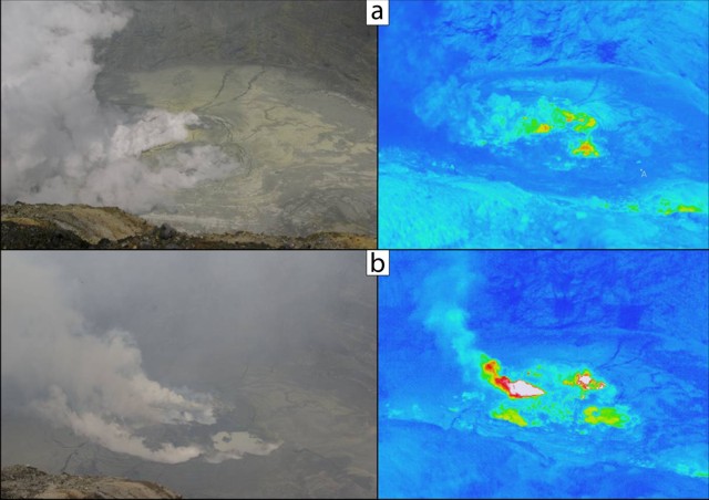 |
Figure 28. Visible (left) and infrared (right) images on two different days (contact JMA for temperature scales). a) 21 April 2011 and b) 15 May 2011. Courtesy of JMA. |
On 16 May, an eruption sent one plume to an altitude of 1.8-2.1 km and another ash plume to 2.4 km, according to the Tokyo Volcanic Ash Advisory Center. A video depicting the plume that day can be found on Youtube (Asahi.com, 2011). The video shows aerial footage of the plume, which is bent downwind. The emission is constant but not vigorous.
Rocks ejected from Naka-dake on 17 May landed in restricted areas, and ash plumes rose to an altitude of 1.8 km. Ash plumes continued rising to similar altitudes through the end of May, and small scale eruptions continued through 10 June, accompanied by low level seismicity. No additional plumes were reported through mid-October. The website of the Mt. Aso Ropeway noted that entry restrictions ended on 20 June 2011, allowing them to carry passengers.
References. Asahi.com, 2011, Naka Erupting, YouTube (URL: http://www.youtube.com/watch?v=uBKJnM2JIZs), posted 16 May 2011.
Tsunogai, U., Kamimura, K., Anzai, S., Nakagawa, F., and Komatsu, K., 2011, Hydrogen isotopes in volcanic plumes: Tracers for remote temperature sensing of fumaroles, Geochimica et Cosmochimica Acta, v. 75, no. 16, p. 4531-4546.
Information Contacts: Japan Meteorological Agency (JMA), 1-3-4 Otemachi, Chiyoda-ku, Tokyo 100-8122, Japan (URL: http://www.jma.go.jp/); Volcano Research Center, VRC-ERI, Univ. Tokyo (URL: http://www.eri.u-tokyo.ac.jp/VRC/index_E.html); Wordtravels (URL: http://www.wordtravels.com/Travelguide/Countries/Japan/Map).
Minor mud ejections resumed in 2011, the first since 2008
This report summarizes Japan Meteorological Agency (JMA) monthly reports (available in English since October 2010) covering the interval April 2011 to September 2012, with a separate subsection largely focused on aviation reports of Aso plumes emitted at Naka-dake crater during mid-2011. During this reporting interval Naka-dake continued to degas and emit small ash plumes. Eruptions of mud resumed after a hiatus of several years (February 2008 to April 2011).
Aso (also called Aso-san) is a caldera with dimensions ~17 km E-W by ~25 km N-S encompassing an area of ~350 km2. Figure 29 indicates the location of Aso in relation to other Holocene Japanese volcanoes and landmarks in the region.
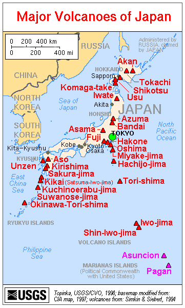 |
Figure 29. A map of the major volcanoes of Japan. Aso is shown on the left side, on the island of Kyushu. Courtesy of the U.S. Geological Survey. |
Aso's most recent series of eruptions began in April 2011, with minor phreatic (mud-bearing) eruptions from Naka-dake's crater lake. These eruptions were accompanied by minor ash plumes, rock ejections, an increase in the temperature of fumaroles (BGVN 36:09), and continuous, small-amplitude tremor.
Field observations during April 2011-June 2011. In April 2011, a small phreatic (mud-bearing) eruption 5-10-m-high was observed in Naka-dake's crater lake; the lake's temperature was 67°C. Volcanic seismicity remained at a relatively low level. A photo from 21 April 2011 shows a white steam plume (figure 30).
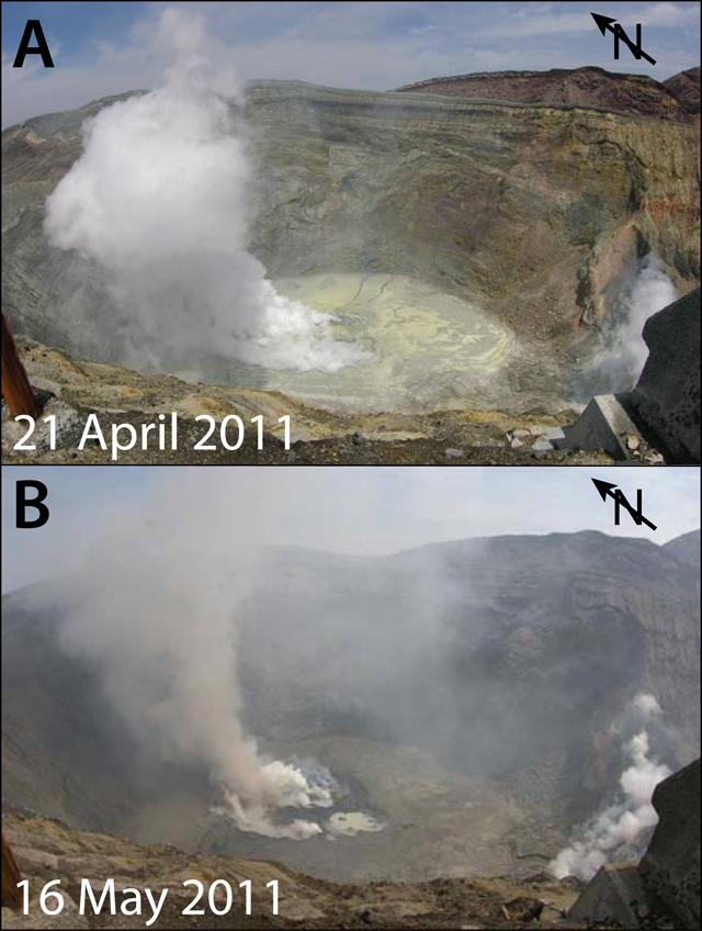 |
Figure 30. (A) A photo taken by a field survey team on 21 April 2011 shows a white steam plume rising from the crater floor. (B) A photo taken on 16 May 2011 shows a grayish plume venting from the crater floor. Courtesy of JMA. |
From 3 to 10 May, continuous small-amplitude tremor was detected. Seismicity, including isolated-pulse events, remained relatively low during this time. On 6 and 9 May, field surveyers observed a small 5-10-m-high phreatic eruption from the hot crater lake (locally called "Yudamari").
A camera installed by the Aso Volcano Museum detected a small volcanic ash emissions from within the crater beginning on 13 May. Six cameras provide live image feeds to the Aso Museum website. There are also many videos showing Aso and Naka-dake on YouTube.
On 13 May, a field survey found increased fumarole temperatures in the crater, and a video camera revealed incandescence on multiple nights. According to JMA, a small eruption occurred on 15 May followed by minor ashfall, which extended 2 km NE of the crater. A field survey on 15 May recorded a temperature of ~370°C at a fumarole in the crater.
Another eruption occurred on 16 May, producing a grayish plume that rose 500 m above the crater rim. As a result of this increased activity, the Alert Level was raised from 1 to 2 (on a scale from 1-5). A field surveyer later the same day saw a gray plume rise 800 m above the crater rim (figure 30). Small-scale eruptions occurred intermittently on the 17th. The lake water volume was low around this time, ~10-20% of its full volume.
A 9 June field survey revealed a decrease in fumarole temperatures from ~370°C on 15 May to ~160°C on 9 June. After 10 June, eruptions ceased and the lake water volume increased from 60% full on 12 June to 80% full on 17 June (figure 31). The rising lake level suggested a decrease in activity. Consequently, the Alert Level was lowered from 2 to 1 on 20 June. Seismicity, including isolated-pulse events, remained at relatively low levels.
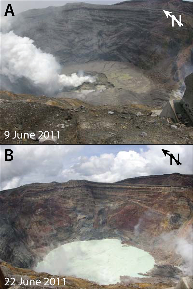 |
Figure 31. (A) Photo taken on 9 June 2011 showing the bottom of Naka-dake crater. Note the absence (or near absence) of the crater's lake. (B) Photo taken on 22 June 2011 showing the presence of the steaming crater lake just about two weeks after the photo in (A) was taken. Courtesy of JMA. |
Plume heights and drift directions during May-June 2011. We summarize reports from the Tokyo Volcanic Ash Advisory Center (VAAC) issued between 15 May and 9 June 2011 (table 10). Many plumes contained ash. Notice that the plume heights are stated as altitudes above sea level (as compared to heights above the crater rim, as in the other sections of this report).
Table 10. Summary of plumes at Aso between 15 May and 9 June 2011. Smaller plumes may not have been recorded or were omitted. In most cases, the presence of ash in the plume was noted; in other cases ash may have been present but not recorded. '-' indicates data not reported. Data provided by Tokyo VAAC and JMA.
| Date | Plume altitude | Drift | Ash? | Pilot/JMA report |
| 15 May 2011 | 2.1 km | NE | Ash | Pilot |
| 16 May 2011 | 1.8-2.1 km | -- | -- | JMA |
| 16 May 2011 | 2.4 km | N | Ash | Pilot |
| 17-18 May 2011 | 1.8 km | E, SE | Ash | JMA |
| 18 May 2011 | 3 km | -- | Ash | Pilot |
| 18-22 May 2011 | 1.5-2.1 km | N, NE, SE | Ash | JMA |
| 25, 27-28, 31 May 2011 | 1.5-1.8 km | NW, N, E, S | Ash | JMA |
| 01-07 June 2011 | 1.5-2.1 km | NW, N, NE, E, S | -- | JMA |
| 08-09 June 2011 | 1.5-1.8 km | NW, N, NE, E | -- | JMA |
Field observations during October 2011-June 2012. In October 2011, white plumes rose on average less than 200 m above the crater rim, with a maximum of 300 m. The lake water volume during September and October was at about 90% full, and the September and October lake-surface temperatures were 47-56°C and 49-58°C, respectively. Based on field surveys made on 3, 17, and 20 October, the sulfur-dioxide (SO2) flux was ~300-500 tons/day, compared to ~300 tons/day in September. Volcanic seismicity remained low. Tremor, detected 13 times during September, was absent during October. The total magnetic intensity measured at the NW rim of the Naka-dake crater had increased since December 2010, but was static during June 2011 through October 2011. No change was detected by GPS measurements.
The next JMA monthly report on Aso discussed activity during May and June 2012. Because of heavy rains after 15 May, the lake water volume had increased to ~70% full, and during the course of the month the volume was in the range 60-80% full. Then in late May, the lake level begain to drop, and continued into at least mid-June.
The lake surface temperature was 63-72°C in May and 67-73°C in June. The highest temperature of fumaroles along the southern crater wall was 246-260°C, compared to 228-267°C in May. Scientists conducting a field survey at night on 22 June noted that part of the S crater wall was incandescent.
In June 2012, white plumes rose an average of 600 m above the crater rim. There were 621 isolated cases of tremor in June, approaching a 2-fold increase over some of the previous months, but only amounting to a duration of a few minutes per month. Isolated volcanic tremor and seismicity remained low but had slightly increased overall after February 2012, with most hypocenters located at shallow depths under Naka-dake. No change was detected by GPS measurements. The total magnetic intensity began to increase again in June 2012.
Lake levels during July-September 2012. In July, heavy rains caused the lake level to rise to 80-90% full (from 30-70% full in June). The volume remained high in August and September (90-100% full). During June-July the lake surface temperature decreased slowly, from 58-66°C in July to 57-61°C in August and to 54-59°C in September. Steam emissions from the crater occurred in July and August, but stopped by September.
Crater temperatures during July-September 2012. The highest temperature of the S wall of Naka-dake-Daiichi crater decreased in July, but rose slightly in August and September (213-250°C in July, 241-249°C in August, and 250-283°C in September). A field survey on 24 September revealed that the hot areas had not changed since the previous survey on 22 June. On 23-26 September, weak glow in the crater was recorded at night by a thermal camera. Officials assumed the glow was caused by the hot crater wall.
July-September 2012 seismicity. Both isolated volcanic tremor and other seismicity returned at low levels during July-September 2012. 621 volcanic tremors occurred in June, 669 in July, 1,025 in August and 867 in September. 669 volcanic earthquakes occurred in July, 951 in August, and 978 in September. Other seismic events occurred 369 times in June, 626 in July, and were not reported in August or September. Few short-term tremors occurred (4 in June, none in July, 2 in August, and 1 in September). Most hypocenters were located at shallow depths (2-4 km) and in an area ~6 km NE of Naka-dake.
Based on field studies, sulfur dioxide levels were elevated during May-September 2012 (600-800 t/d in May, ~400 t/d on 10 July, and 500-700 t/d on 19 and 24 September). The total magnetic intensity at the NW rim of Naka-dake-Daiishi crater increased between December 2010 and September 2012, which officials suggested might signify a temperature rise underneath the crater.
Information Contacts: Japan Meteorological Agency (JMA), Otemachi, 1-3-4, Chiyoda-ku Tokyo 100-8122, Japan (URL: http://www.jma.go.jp/); Tokyo Volcanic Ash Advisory Center (VAAC), Tokyo, Japan (URL: http://ds.data.jma.go.jp/svd/vaac/data/); Aso Volcano Museum (URL: http://www.asomuse.jp/); Volcano Discovery (URL: http://www.volcanodiscovery.com/); Earth Observation Research Center (Japan) (URL: http://www.eorc.jaxa.jp/en/index.php).
Ongoing emissions leading to a larger, late-2014 eruption with ashfall
This report summarizes behavior at Naka-dake (Nakadake) crater at Asosan (Aso, Aso-san) caldera chiefly during January 2014-February 2015. During this reporting interval Naka-dake continued to emit gas, steam, and small ash plumes. A larger eruption took place starting 25 November 2014, causing ashfall and glowing emissions. This closed a local airport, and triggered hundreds of reports on ash plumes for the aviation community by the Tokyo Volcanic Ash Advisory Center (VAAC). That eruption continued through 2014. The eruption went on into 2015 but was generally described as intermittent during late December 2014 through at least the end of February 2015. The Alert Level remained at 2 (on a scale increasing from 1 to 5) for the duration of the reporting interval. Our last report, BGVN 37:08, described the emission of ash plumes and other behavior during May-June 2011. Some remarks in this report also refer to earlier behavior, for example, a short subsection includes what JMA recorded as important in a terse summary of 2011.
Eruption details were extracted and synthesized mainly from Japan Meteorological Agency (JMA) sources. JMA frequently communicated with the Tokyo VAAC about Asosan's eruptive status. This report also discusses Volcano Ash Advisories (VAAs) issued by the JMA's Tokyo VAAC. For many of the VAAs, evidence of ash-bearing plumes reported by JMA could not be reliably detected in the satellite images. For example, the images were sometimes obscured by overlying weather-cloud cover. The plumes were also generally only rising to a few kilometers in altitude. In at least some cases, the low plumes appeared bent by high winds.
Naka-daka Crater Number 1 remained the active vent for the most part during the past eight decades. That same pattern held true during this reporting interval when myriad small eruptions, often to or below 1 km above the crater rim were documented. Visibility was sometimes impaired but monitoring instrumentation confirmed a pattern of ongoing eruption. In some cases, the eruption was not clearly seen but fresh ash was recorded. Webcameras regularly documented incandescence both in the crater and onto the crater rim. Smaller ash plumes were too numerous to mention except in occasional cases. High winds were often mentioned, which may have bearing on restricting plume heights.
Location and brief background. Asosan is located on the S of the main island of Japan (Honshu) on the island of Kyushu (figure 32).
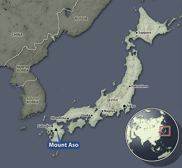 |
Figure 32. Location maps showing (circular 'global' inset) Japan, and (larger map) the location of Asosan (Aso) on Kyushu island. Taken from The Daily Mail news article issued on 28 November 2014 (Malm, 2014). |
The rim of Nake-dake is unusually developed for such an active volcano. Both a road and cable car carry tourists there. Shelter dugouts are provided around the crater. The Aso Volcano Museum is located nearby. Figure 33, made from radar imagery, shows Asosan's morphology.
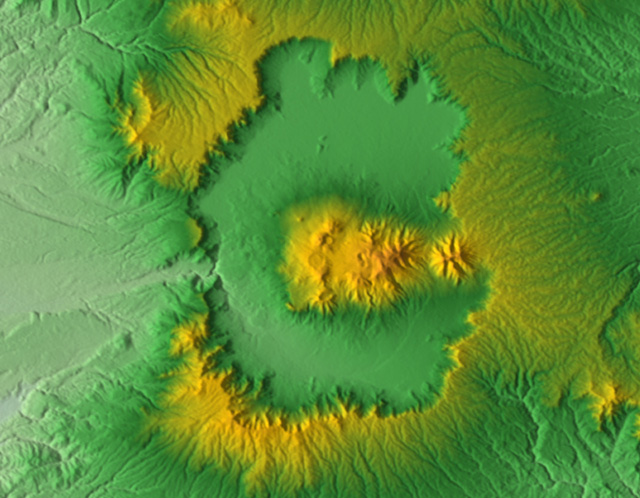 |
Figure 33. Morphology of the Asosan caldera seen in shaded relief (color scale for elevations absent). N is towards the top; the N-S cross-caldera distance is ~25 km. Note the central highlands, a series of ~17 post-caldera cones that includes the active Nake-dake and its Crater Number 1. The caldera's topographic boundary is distinct on all sides but a drainage has breached the W side. This caldera vented four sets of massive eruptive deposits (pyroclastic-flows and associated ash-falls; Miyabuchi, 2013; Fujii, 2001). Source: Wikipedia (from a Nasa Shuttle Radar Topography Mission). |
JMA (2013) includes a map showing the location of 12 calderas in Japan. Asosan, the largest and most active, has had many small eruptions in the past few thousand years, including many witnessed eruptions in the interval of recorded history. Spica (2013) discusses Aso in the context of other calderas in the Kyushu region. Figure 34 shows a shaded-relief map focusing on the post-caldera cones in the central highland area.
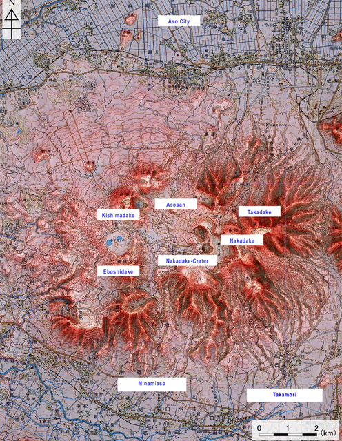 |
Figure 34. A shaded relief map of the elevated central area (post-caldera cones and their craters) of the Aso caldera, adding naming labels in English of some of the main features. As seen in the previous figure, the caldera floor (moat) is outside and encircling this central topographic high. Both conventional topographic and a digital elevation map (50 m grid) were used to make this map, which was published by the Geospatial Information Authority of Japan. Source: JMA (2013). |
JMA's website features this summary on Asosan.
"Asosan (Aso Volcano) comprises the Aso caldera and post-caldera central cones. The Aso caldera, 25 km north-south and 18 km east-west in diameter, was formed by four gigantic pyroclastic-flow eruptions from approximately 270,000 to 90,000 years ago. Post-caldera central cones were initiated soon after the last caldera-forming eruption, producing not only local lava flows but also voluminous tephra layers which fell far beyond the caldera. Nakadake Volcano, which is the only active central cone of basaltic andesite to basalt [composition], is one of the most active volcanoes in Japan. The active crater of Nakadake Volcano is a composite of seven craterlets aligned N-S [elongate zone of depressions to the left of the label "Nakadake" and above the letter 't' in the label "Nakadake-Crater" on figure 34; see also SEAN 04:07 for a sketch map focused on this area)]. Only the northernmost [Nakadake] crater (No. 1 crater) has been active in the past 80 years, although some others were active before the 1933 eruption. The Nakadake No. 1 crater is occupied by a hyperacidic crater lake during its calm periods. During active periods, its volcanic activity is characterized by ash and strombolian eruptions and phreatic or phreatomagmatic explosions."
According to Fujii and others (2001), "Aso caldera in central Kyushu, Japan, is one of the largest calderas in the world and covers an area of 380 km2. In late Pleistocene time, eruptions of voluminous pyroclastic flows occurred intermittently, resulting in formation of the caldera. The Aso pyroclastic-flow deposits are divided into four major units, i.e. Aso-1, Aso-2, Aso-3, and Aso-4 . . . [and] welded tuffs of these units are widely distributed in central Kyushu, and are generally well suited for paleomagnetic research . . .. K-Ar ages for Aso-1, Aso-2, Aso-3, and Aso-4 have been determined to be 266 ± 14 ka, 141 ± 5 ka, 123 ± 6 ka, and 89 ± 7 ka, respectively (Matsumoto and others, 1991)."
JMA summary for 2011 activity. JMA (2013) tabulated a summary of witnessed events (eruptions, possible eruptions, damage, significant behavior, etc.) at Asosan going back to the year 553. In the most recent behavior discussed, the authors briefly note that during 2011 (an interval they term Heisei 23) the following behavior occurred.
First, after the Mw ~9 Tohoku earthquake ~70 km off the Pacific coast on 11 March 2011, earthquakes temporarily increased roughly 10 km to the NW of the active crater. Second, very small emissions of gray-white volcanic ash occurred during 15 May to 9 June 2011. On 15 May a very small amount of tephra fall was confirmed at Sensuikyo, ~2 km to the NE of the Nakadake Number 1 crater.
2014 Activity. JMA reporting for 13 January 2014 noted the emission of a very small eruption. This came in the wake of increased tremor in late December 2013 and an increase in hazard status to Alert Level 2. (As previously mentioned, the Level remained at 2 for the duration of the reporting interval.) Further escalation in tremor took place on 2 January. On 10 January emissions reached 1,200 metric tons/day (t/d) of sulfur-dioxide (SO2). The 13 January 2014 eruption took place at Naka-dake, which emitted a grayish-white plume that rose to 600 m that traveled S and deposited traces of ash. The resulting report from the Tokyo VAAC (a Volcanic Ash Advisory (VAA)) stating they failed to detect identifiable ash in the plume data captured on satellite images.
The small 13 January 2014 eruption triggered the first Asosan VAA in over a year. The other VAAs during January 2014 were issued on the 27th, 29th, 30th, and 31st. On one of those days, two VAAs were issued, and thus, for January there were 6 VAAs.
Bulletin editors note that the VAAs are not a linear measure of the number of eruptions. Small eruptions may not trigger a VAA at all. Several consecutive VAAs may occur associated with a single potentially larger eruption, which are issued in an effort to track an ash plume. Again, this may be an example where the number of VAAs is not reflective of the number of eruptions. Despite this, the number of VAAs are easily counted owing to new online archives. The Tokyo VAACs online presentation system is tablular in nature and is thus well suited to enable a count of reports per month.
The tally for VAAs on Asosan during 2013 was zero. The tally for 2014 involved 171 VAAs. Monthly totals for 2014 are as follows: January, 6; February, 3; March-July, 0; August, 3; September, 2; October, 0; November, 25; and December, 132. For further comparison, the tally for January and February 2015 involved 250 VAAs, with January, 132, and February, 118.
JMA reported that seismicity increased from 21 to 23 January 2014, and then decreased on 24 January. On 23 January a volcanologist observed ash plumes rising from the central vent on the crater floor. On 29 January an ash plume reported by a pilot rose to 2.7 km altitude and drifted NW. Later that day a plume rose to an altitude of 1.5 km and drifted N. JMA reported that a very small Asosan explosion occurred on 31 January. An off-white plume rose 100 m above the crater rim and drifted S.
On 5 February 2014 scientists measured decreased SO2 emissions and fewer volcanic earthquakes.
According to the Tokyo VAAC during 30 August-1 September 2014 eruptions continuously emitted ash plumes that rose to heights of 1.2-2.1 km drifting N and NE. For example, on 1 and 6 September eruptions emitting trace amounts of ash sent plumes 600 m above the rim. (Tokyo VAAC issued VAAs stating this plume lacked identifiable ash in available satellite images.) JMA instrument surveys established SO2 flux rates on 21 August of 1,000 t/d, and in early September of 1,200 tons/day. Counts tallying daily volcano-tectonic earthquakes (and cases of tremor) were made during 1-4 September occurring in the range 48-92 (429-500); during 5-7 September occurring the in the range 55-129 (401-463); during 8-15 September occurring in the range 394-564 (80-174).
JMA reported that during 8-16 September a persistent white plume was observed 1 km above the crater.
Preliminary counts for volcanic earthquakes (394-564 per day) and tremor (80-174 per day) were reported during 8-15 September. Field surveys conducted on 9 and 12 September yielded elevated temperatures from fumaroles and the surface of the S crater wall.
Tremor accompanied a very small eruption recorded on 22-24 October. Ashfall observed on the 24th indicated another such eruption.
During 7 September and 24 November 2014, VAAs were absent for Aso. In contrast, during 25 November 2014-31 December 2014 there were 171 VAAs issued. Multiple VAAs were issued on several different days in this later interval, for example, on 26 November, 7 VAAs were issued.
Asosan continued to erupt during the 7 September-24 November 2014 interval. Some monitored parameters such as earthquakes, tremor, and SO2 emissions were elevated. A small eruption took place on 6 September, for example, sending a plume to 600 m above the crater. During 8-16 September JMA noted a persistent white plume 1 km above the crater. During the week 12-18 November, a steam plume rose 400 m above the crater rim.
With the start of the surge in VAAs beginning on 25 November 2014 (noted above), a stronger and comparatively sustained eruption began. During the eruption on the 25th an ash plume rose to 1.8 km above the crater rim. Ash soon fell to the E in Hanoi Aso (Kumamoto Region), Taketa (30 km NE, Oita Region), Gokase (25 km WSW, Miyazaki Region), and in Minamiaso (10 km SW, Kumamoto Region). Incandescence at night was seen with webcams.
On 26 November tephra ascended 100 m above the crater rim and an ash plume rose 1 km. Tremor began a few hours before the eruption and on the 26th, continued to be elevated. The eruption continued on 27 November; ash plumes rose 1.5 km. Volcanologists observed a strombolian eruption and found 7 cm of fresh ash that contained fist-sized scoria. Ash fell to the W, affecting the city of Kumamoto (38 km WSW). According to a news article, flights in and out of Kumamoto airport were either cancelled or diverted. On 28 November ash plumes rose 1.5 km. The eruption continued through at least 30 November; ash plumes rose at most 1.5 km and incandescent material was ejected onto the crater rim.
Although inclement weather restricted views of the crater, monitored parameters and available views indicated that the 25 November eruption continued through to at least 22 December, when it became intermittent. Ash plumes to about 1 km above the crater rim and incandescent material on the crater rim were common through the end of the year (and beyond, through this reporting interval ending in February 2015, and described as the ongoing eruption.
A news report in the 28 November 2014 issue of the Daily Mail by Sara Malm (Malm, 2014) indicated dozens of cancelled flights at Kumamoto's airport. That report included the Associated Press photo seen in figure 35. The date of the photo in that article was ambiguous, but a different article with the same photo (see caption) gave 26 November 2014 as the photo's date. The angled, bent-over character of the ash plume and location of Crater Number 1 (the active crater, at the N end of the row of craters) indicate the view was from the NW and implies strong winds roughly from the N.
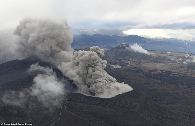 |
Figure 35. A photo taken on 26 November 2014 of Asosan in eruption. The gray ash plume is escaping at Nake-dake Crater Number 1 blowing roughly S. The plume does not rise vertically. The plume ascends near the vent but for some distance beyond the vent the plume descends. At distance the plume appears to spread over considerable vertical extent, from near the ground surface to above the field of view. Source: Phys.Org news (crediting AP/Kyodo News). |
An undated video in Malm (2014) also showed the plume. The video also showed an aerial view of the visitor area on the crater rim, which was blanketed in gray ash. Other scenes included children walking to school wearing dust masks and carrying folded umbrellas, and close up shots of what appeared to be dark colored, highly vesicular spatter.
In a 29 November 2014 MODIS image of the region, Asosan was under weather clouds but a clear view revealed a prominent ~30-km-long, beige-colored, funnel-shaped area trending SE. This was interpreted by Nasa Earth Observatory authors Jeff Schmaltz and Adam Voiland as airborne ash. Webcamera images around this time showed a glowing pit crater with extensive areas containing incandescent tephra around it. A copious plume also discharged nearby.
During a field survey on 10 December volcanologists observed 20-cm-wide blocks near the crater and 5- to 10-cm-wide blocks within 1.2 km SW of the crater. During 12-15 December the plume rose 1 km above the crater rim and ash fell to the E in Hanoi Aso (Kumamoto Region).
JMA reports for 15-30 December described the usual eruptive ash plumes that again rose 600-1,000 m above the crater and some cases of still glowing material on the crater rim. SO2 fluxes were 2,000-3,100 t/d during 15 and 18 December.
2015 activity. As noted above, the VAAs for 2014 totaled 171, and the VAAs for the months of January and February 2015 totaled 250. This is consistent with ongoing eruption at Asosan, which was also the basic conclusion in JMA reports from monitoring and direct observations during January-February 2015, although they often described the eruption during both these months as intermittent.
JMA reported cases during January where plumes rose up to 1 km above the crater, and in some cases glowing material reached the crater rim. JMA reported SO2 fluxes of 500-2600 tons of SO2. Both tilt and GPS instrumentation recorded slight growth across the active crater. A pilot report on 29 January indicated an ash plume to 2.7 km altitude (~1.1 km above the rim) and drifting NW.
An image acquired on 13 January 2015 was discussed by Jesse Allen and Adam Voiland of Nasa Earth Observatory. They reported that the image was from the Operational Land Imager (OLI) on Landsat 8. They indicated that it showed ash drifting ten's of kilometers S from Aso.
For February 2015, JMA reported episodes of volcanic earthquakes, high-amplitude tremor, and infrasound data that continued to indicate ongoing intermittent eruptions. Webcamera views again documented cases of glowing material reaching the rim during the first half of the month. Plumes again rose up to 1 km above the crater rim. JMA reported intermittently detected eruptions, including during 2-6, 9-13, and 16-20 February.
References.
Fujii, J., Nakajima, T., & Kamata, H., 2001, Paleomagnetic directions of the Aso pyroclastic-flow and the Aso-4 co-ignimbrite ash-fall deposits in Japan. Earth, planets and space, 53(12), 1137-1150. (URL: http://download.springer.com/static/pdf/873/art:10.1186/BF03352409.pdf?originUrl=http://link.springer.com/article/10.1186/BF03352409&token2=exp=1434307643~acl=/static/pdf/873/art:10.1186/BF03352409.pdf?originUrl=http://link.springer.com/article/10.1186/BF03352409*~hmac=b718e24427a5900c5057d59ebb12b501c1ae870b932122de89cc3a01a5f5318f ).
JMA (Japan Meteorological Agency), 2013, National Catalog of the Active Volcanoes of Japan (4th edition; online English version), (URL: http://www.data.jma.go.jp/svd/vois/data/tokyo/STOCK/souran_eng/menu.htm ) (accessed in June 2015)
Khin, K, 2013, Field trip to Aso volcano, Kyushu, Japan, Slideshare.net (13 annotated slides) (URL: http://www.slideshare.net/kyikyaw2/field-trip-to-aso-volcano-kyushu-japan )
Malm, S, 2014, Flights cancelled across Japanese region after Mount Aso volcano erupts for the first time in 22 years, spewing lava, smoke and a kilometre-high ash cloud, The Daily Mail 28 November 2014 (7 graphics files and a 58-second video) (accessed online June 2015) ((URL: http://www.dailymail.co.uk/news/article-2852674/Volcano-south-Japan-erupts-disrupting-flights.html#ixzz3d5POqZhu )
Matsumoto, A., K. Uto, K. Ono, and K. Watanabe, 1991, K-Ar age determinations for Aso volcanic rocks—concordance with volcano stratigraphy and application to pyroclastic flows, Abstracts to Fall Meeting in 1991, Volcanol. Soc. Japan , 73 (in Japanese).
Miyabuchi, Y, 2013, A 90,000-year tephrostratigraphic framework of Aso Volcano, Japan, Sedimentary Geology, Volume 220, Issues 3–4, 15 October 2009, Pages 169-189, ISSN 0037-0738, (URL: http://dx.doi.org/10.1016/j.sedgeo.2009.04.018 ; http://www.sciencedirect.com/science/article/pii/S0037073809001006 )
Spica, 2013, Southern Japan Calderas, Volcano Café (Volcano discussions in your living room), Wordpress.com (22 July 2013)(accessed June 2015) (URL: https://volcanocafe.wordpress.com/2013/07/22/southern-japan-calderas/ )
Information Contacts: Japan Meteorological Agency (JMA), Otemachi, 1-3-4, Chiyoda-ku Tokyo 100-8122, Japan (URL: http://www.jma.go.jp/); Tokyo Volcanic Ash Advisory Center (VAAC), Tokyo, Japan (URL: http://ds.data.jma.go.jp/svd/vaac/data/); Aso Volcano Museum (URL: http://www.asomuse.jp; and Jeff Schmaltz and Adam Voiland, NASA Earth Observatory (URL: http://earthobservatory.nasa.gov).
Lengthy eruptive episode 25 November 2014-May 2015; major explosions on 14 September 2015 and 8 October 2016
Japan's 24-km-wide Asosan caldera on the island of Kyushu has been active throughout the Holocene. Nakadake has been the most active of 17 central cones within the caldera for 2,000 years. Historical eruptions have been primarily basaltic to basaltic-andesitic ash eruptions, with periodic Strombolian activity. Minor ash emissions during May-June 2011, January-February 2014, and August-September 2014 preceded a major eruptive episode which began in late November 2014 and continued through 1 May 2016. Another eruption, with the largest ash plume in 20 years, occurred on 8 October 2016. The Japan Meteorological Agency (JMA) provides regular reports of activity; the Tokyo Volcanic Ash Advisory Center (VAAC) issues aviation alerts reporting on possible ash plumes. This report covers the period from the beginning of the late 2014 episode through March 2017.
Minor ash eruptions occurred at Asosan during 13 January-19 February 2014 and 30 August-6 September 2014. Trace ashfall was reported on 24 October 2014. A new large eruptive episode began in late November with ash plumes and Strombolian activity that continued from 25 November 2014 through late May 2015. Ash explosions also occurred on 28 June, 8 August, and 3 and 10-11 September 2015. A large explosion with pyroclastic flows occurred on 14 September. This was followed by intermittent ash plumes until 23 October 2015. Minor ash explosions took place on 7 and 25 December 2015. More explosions with ash were recorded on 17-18 February, 4 March, 16 and 30 April, and 1 May 2016. Nakadake crater was then quiet until a large explosion with an 11.9-km-high ash plume on 8 October 2016, after which no further explosive activity was reported through March 2017.
Activity during January-October 2014. After no activity during 2012 and 2013, increased seismicity in December 2013 preceded a series of minor ash eruptions between 13 January and 19 February 2014 (BGVN 40:02). The largest, on 29 January, rose 2.7 km and drifted NW. The next episode began on 30 August and lasted for only a week until 6 September 2014. The ash plumes were continuous during most of this brief time, but only rose as high as 2.1 km, and drifted N and NE. Other than a small amount of ashfall reported on 24 October, only steam plumes issued from Nakadake between early September and 25 November, the beginning of a lengthy eruptive episode.
Activity during November 2014-May 2015. The details of the beginning of this episode have been covered in a previous Bulletin report (BGVN 40:02). Ashfall was reported from ash plumes in several directions (NE, WSW, SW) as far as 38 km away, although plume heights were seldom above 2.4 km altitude (figure 36). Incandescence was observed at night from the webcams. Strombolian activity occurred from two active vents at Nakadake, producing frequent explosions of incandescent material onto the crater rim (figure 37). Blocks up to 10 cm wide were observed by JMA scientists within 1.2 km SW of the crater in mid-December 2014.
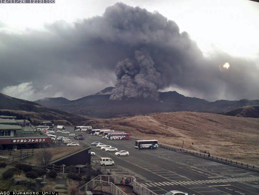 |
Figure 36. Ash plume from Asosan on 26 November 2014. Image taken from Kumamoto University webcam located about 1 km SW of Nakadake crater. Courtesy of Volcano Discovery. |
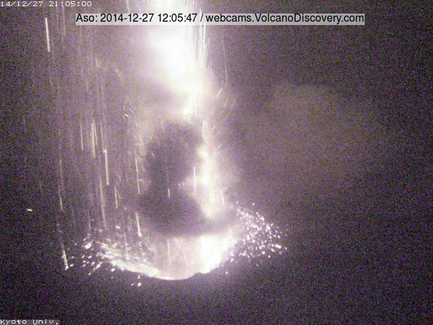 |
Figure 37. Strombolian activity at the Nakadake crater at Asosan on 27 December 2014. Image taken from the Kyoto University webcam located at Nakadake crater which was destroyed during a subsequent eruption. Courtesy of Volcano Discovery. |
Ash plumes and Strombolian activity continued from 25 November 2014 through late May 2015. The Tokyo VAAC issued near-daily reports through early May, when they became more intermittent until a month-long break beginning on 26 May. Plume heights were rarely higher than 1.5 km above the rim (3 km altitude). Field surveys noted intermittent ejecta from the Strombolian activity as high as 300 m above the crater rim. Ashfall was reported in the surrounding Kumamoto (W), Oita (NE), and Miyazaki (SE) prefectures (figure 38).
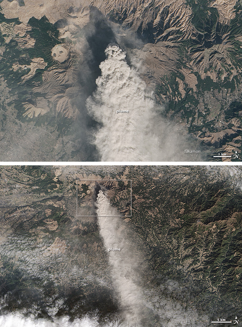 |
Figure 38. A dense ash plume drifting S from Asosan on 13 January 2015. The ash plume is visible for at least 30 km. Upper image is the inset box of lower image. Courtesy of NASA Earth Observatory. |
The JMA report for February 2015 noted that observations conducted by Kumamoto University indicated that as much as 1,500,000 tons of ash fell from the start of the eruption on 25 November 2014 through 2 February 2015. The results of GNSS (Global Navigation Satellite Systems) measurements suggested a slight inflation across Kusasenri, another cone located W of Nakadake, during February. In late April, ashfall was reported in areas to the SE and NE. A large-amplitude tremor that lasted for 5 minutes was recorded on 3 May. During a field survey on 5 May, JMA scientists observed that the S side of one of the pits (named the 141st pit) in the Nakadake crater had collapsed. On 26 May, an ash plume at 2.1 km altitude was reported 37 km NE of Kumamoto airport (about 25 km W of Asosan). This was the last ash plume reported until 28 June.
Activity during June-October 2015. A field survey by JMA personnel on 10 June noted a lake in part of the 141st pit. Thermal infrared measurements indicated temperatures of up to 80°C in the lake, which had not been observed since 8 July 2014; the lake had disappeared by 29 June. An ash plume was reported by the Tokyo VAAC drifting SW at 1.5 km altitude on 28 June.
Tremor amplitude began decreasing by mid-July, but the number of isolated tremors remained large. Steam plumes and a crater lake were again observed at the 141st pit in late July and August, and temperatures remained high (80-90°C) at the lake. A high-temperature fumarole (around 600°C) was observed SW of the 141st pit on 31 July and again during August. A small eruption was reported on 8 August by JMA with grayish plumes rising 600 m above the crater rim and minor ashfall reported on the S side of the crater. The Tokyo VAAC reported minor ash plumes on 3 and 10-11 September.
A series of new larger explosions began early on 14 September 2015 local time. JMA raised the Alert level from 2 (Do not approach the crater) to 3 (Do not approach the volcano) (on a scale of 1-5) the same day. The ash plumes were reported by JMA at 2,000 m above the crater rim drifting NW. A pyroclastic flow and ejecta impacted the immediate area around the crater. Aerial observation later that day noted discoloration extending 1.3 km SE and 1 km NE from the Nakadake crater as a result of the pyroclastic flow. Ashfall was also observed in areas to the W of the crater from northern Kumamoto Prefecture (including Tamana (50 km NW), Kumamoto City (40 km W), and Yamaga (40 km NW)) to Fukuoka Prefecture (more than 30 k NW). According to a news article in The Japan Times, about 30 tourists in the immediate area were evacuated, and some flights were either canceled or re-routed from Kumamoto Airport, 20 km W. Areas within 4 km of the craters were closed. The Tokyo VAAC reported the plume from the 14 September explosion at 3.7 km altitude drifting NW. During an overflight the following week, scientists observed evidence for pyroclastic flows as far as 3 km SE from the crater. Scientists from Kumamoto University estimated that about 40,000 tons of ash were ejected on 14 September.
Ash plumes were reported daily by the Tokyo VAAC until 23 October 2015, when several small explosions sent plumes up to 1.6 km above the crater rim. A field survey that day noted bombs scattered over the W and NW flank of the crater. After this, only steam plumes to 300 m above the rim were reported from Nakadake during November, leading JMA to lower the Alert level to 2 on 24 November.
Activity during December 2015-May 2016. A small explosion occurred on 7 December 2015. A field survey later that day revealed minor ashfall on the SW side of Nakadake crater. Visual confirmation of emissions associated with a relatively large-amplitude tremor on 25 December was obscured by clouds. During a 7 January 2016 survey, staff from JMA and the Aso Volcanological Laboratory observed fresh ejecta up to 0.5 m in diameter as far as 100 m SW of the crater rim, inferring that it resulted from the 25 December explosion.
The next reported ash eruptions took place on 17-18 February 2016. A field survey on 17 February revealed ashfall in Takamori (7 km SSE). Another survey on 18 February noted lapilli along the SW crater wall from the 17 February explosion. After the 18 February explosion, lapilli were observed 400 m NW of the crater and ashfall was noted in Aso City (10 km NE). Two MODVOLC thermal alerts on 28 February were located about 2 km NE of the active crater and likely unrelated to volcanic activity.
An explosion early in the morning on 4 March 2016 sent a milky-white plume to 1 km above the crater rim. A field survey later in the day confirmed slight ashfall on the E side of the crater. Small explosions were reported by JMA on 16 and 30 April. The Tokyo VAAC issued advisories, but ash was not detected in satellite imagery. The Tokyo VAAC issued no further advisories until 7 October 2016, although JMA noted a small explosion on 1 May with gray-white 'smoke' rising to 300 m above the crater. This was the last reported explosion by JMA until 7 October 2016. Seismic tremor amplitudes decreased after 15 May. During July through September, JMA noted that most of the crater floor was filled with hot water, and seismicity was low and intermittent.
Activity during October 2016-March 2017. After an explosion late in the day on 7 October 2016 and another one in the early hours of 8 October, JMA raised the Alert Level to 3. The Tokyo VAAC reported a large ash plume rising to 11.9 km altitude early on 8 October, and drifting NE. During an overflight on 8 October and a field survey on 12 October, significant ash deposits were observed (figures 39 and 40). They extended as far as 1.6 km on the NW flank and 1 km on the SE flank; ash was also abundant on the NE flank.
 |
Figure 39. View to the N of ash deposits around the Nakadake crater at Asosan after a large explosion on 8 October 2016. Photo by Kyodo/via Reuters. |
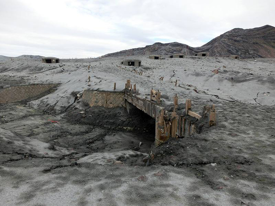 |
Figure 40. Area on the SW side of Asosan's Nakadake crater covered with ash by the explosion on 8 Oct 2016. Note the six bunkers on the left side of the crater in figure 39. They correspond to the bunkers in this image. Photo: JMA. Courtesy of Volcano Discovery. |
Ashfall 3 cm thick was reported at the Aso City police station 6 km NE of Nakadake crater in Kumamoto Prefecture (figure 41). Ashfall was also confirmed in Oita (50 km NE), Ehime (across the Inland Sea, 150 km NE), and Kagawa (300 km NE) prefectures. According to news articles (Reuters), ashfall was reported as far away as 320 km. Kyoto University Volcano Research Center estimated the amount of ash ejected on 8 October to be around 50-60,000 tons. Samples analyzed by the National Institute of Advanced Industrial Science and Technology (AIST) and the National Research Institute for Earth Science and Disaster Prevention (NIED) revealed a 10% juvenile magma component, and that the explosions were possibly phreatomagmatic. Inflation was recorded near the crater up until 8 October, after which it remained steady.
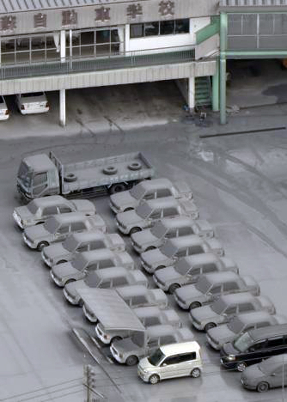 |
Figure 41. Cars are covered with volcanic ash from Asosan in Aso City, about 10 km NE of Nakadake crater in Kumamoto prefecture on 8 October 2016. Photo credit: Kyodo/via REUTERS. |
On 12 November 2016, JMA observed incandescence at night at Nakadake crater for the first time since 26 April 2015. While SO2 emissions were reported as continuous after the 8 October explosion, the volcano was otherwise quiet and JMA lowered the Alert Level to 2 on 20 December 2016. There was no change of activity during January 2017, and thus the Alert Level was lowered to 1 on 7 February 2017. Field surveys during February noted that 80% of the bottom of Nakadake was filled with hot water. JMA reported no further activity through the end of March 2017.
Information Contacts: Japan Meteorological Agency (JMA), Otemachi, 1-3-4, Chiyoda-ku Tokyo 100-8122, Japan (URL: http://www.jma.go.jp/); Tokyo Volcanic Ash Advisory Center (VAAC), 1-3-4 Otemachi, Chiyoda-ku, Tokyo, Japan (URL: http://ds.data.jma.go.jp/svd/vaac/data/); NASA Earth Observatory, EOS Project Science Office, NASA Goddard Space Flight Center, Goddard, Maryland, USA (URL: http://earthobservatory.nasa.gov/); Tom Pfeiffer, Volcano Discovery (URL: http://www.volcanodiscovery.com/); The Japan Times (URL: http://www.japantimes.co.jp/news/2015/09/14/national/mount-aso-erupts-belching-black-plume/#.WRBxXlXyuJD); Reuters (URL: http://www.reuters.com/article/us-japan-volcano-idUSKCN12804E?il=0).
Multiple brief ash emission events during April and May 2019; minor ashfall in adjacent villages
Japan's 24-km-wide Asosan caldera on the island of Kyushu has been active throughout the Holocene. Nakadake has been the most active of 17 central cones within the caldera for 2,000 years. Historical eruptions have been primarily basaltic to basaltic-andesitic ash eruptions, with periodic Strombolian activity, all from Nakadake Crater 1. The most recent major eruptive episode began in late November 2014 and continued through 1 May 2016. Another eruption, with the largest ash plume in 20 years, occurred on 8 October 2016. Asosan remained quiet until renewed activity from Crater 1 began in mid-April 2019; it is covered in this report, through the end of June 2019. The Japan Meteorological Agency (JMA) provides monthly reports of activity; the Tokyo Volcanic Ash Advisory Center (VAAC) issues aviation alerts reporting on possible ash plumes.
Asosan remained quiet during 2017 and 2018 with steam plumes rising a few hundred meters from Crater 1 and low levels of SO2 emissions; a warm acidic lake was present within the crater. Fumarolic activity from two areas on the S and SW wall of the crater rim generated occasional thermal anomalies in satellite data and incandescence at night. A brief period of increased seismicity was reported in mid-March 2019. An increase in seismic amplitude on 14 April 2019 preceded a small explosion on 16 April; it produced an ash plume which rose 200 m above the crater rim and drifted NW. It was followed by additional small explosions on 19 April. A new explosion on 3 May produced minor ashfall in adjacent communities; ash emissions were reported multiple times during May with plumes reaching 1,400 m above the crater rim. No additional ash emissions were reported in June.
Activity during 2017 and 2018. JMA reported that no eruptions occurred during 2017. Amplitudes of volcanic tremor increased somewhat during March but were generally low for the rest of the year. The earthquake hypocenters were mostly located near the active crater at around sea level. SO2 emissions were slightly less than 1,000 tons per day (t/d) from January through April; for the rest of the year they ranged from 600 to 2,500 t/d. The Alert Level had been lowered from 2 to 1 on 7 February 2017 where it remained throughout the year. Steam plumes generally rose no more than 600 m above the active crater rim (figure 42). JMA noted that from January to June they often observed crater incandescence at night with a high-sensitivity surveillance camera; Sentinel-2 satellite images also captured thermal anomalies a few times (figure 43). The green lake inside the crater persisted throughout the year with water temperatures of 50-60°C. Two fumaroles were present with high-temperature gas emissions on the SW and S crater walls. Temperatures at the S crater wall were over 600°C from February to May; they decreased to 320-560°C during the rest of the year (figure 44). Sulfur deposits were visible around the SW crater wall fumarole during July.
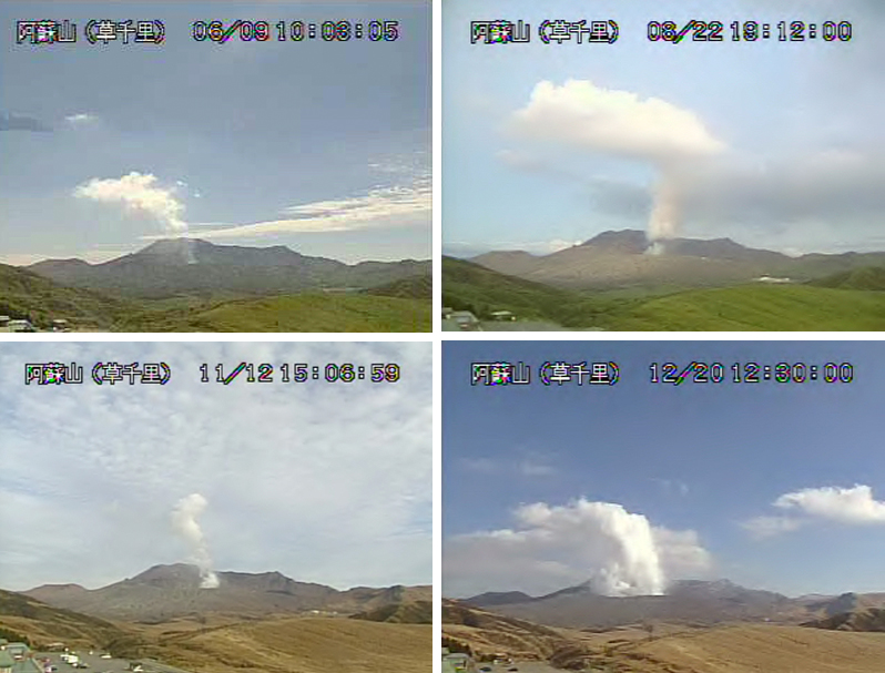 |
Figure 42. Steam plumes that rose around 600 m above Nakadake Crater 1 at Asosan were typical activity throughout 2017. Images taken with JMA webcam on 9 June (top left), 22 August (top right), 12 November (bottom left), and 20 December (bottom right) 2017. Courtesy of JMA (Aso volcano monthly activity reports, Fukuoka District Meteorological Observatory, Regional volcano monitoring and warning center). |
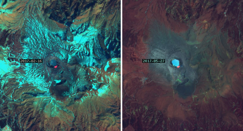 |
Figure 43. Sentinel-2 images captured thermal anomalies at the S rim of the green lake at Asosan's Nakadake Crater 1 on 16 February (left) and 27 May 2017 (right). JMA reported that incandescence was occasionally visible during the night from January-June from the same area. Courtesy of Sentinel Hub Playground. |
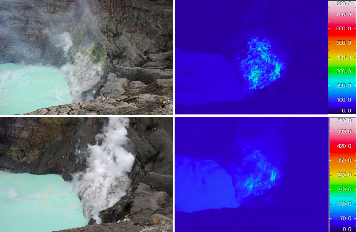 |
Figure 44. High-temperature gas and steam from fumaroles on the S wall of the Nakadake Crater 1 at Asosan on 24 August (top) and 17 November 2017 (bottom) were persistent all year, with temperatures ranging from 300 to over 600°C. The green lake inside the crater persisted throughout the year as well with water temperatures of 50-60°C. Courtesy of JMA (Aso volcano monthly activity reports, Fukuoka District Meteorological Observatory, Regional volcano monitoring and warning center). |
The Alert Level did not change at Asosan during 2018, and no eruptions were reported. Sulfur dioxide emissions fluctuated between 400 and 1,800 t/d throughout the year. Steam plumes generally rose less than 500 m above the active crater (figure 45); incandescence was observed at night during May-October and sometimes observed in satellite imagery as thermal anomalies (figure 46). The temperature of the green lake inside the crater ranged from 58 to 75°C throughout the year. The thermal anomaly on the S wall of the crater was consistently in the 300-500°C range, and had a high temperature in April of 580°C; in December the high temperature had risen to 738°C (figure 47). A brief increase in the number of isolated tremors occurred during March, with 1,044 reported on 4 March, exceeding the previous maximum of 1,000 on 27 October 2014. Seismicity also increased briefly during June, with more than 400 events reported each day on 8, 18, and 20 June. The Minami Aso village Yoshioka fumarole zone, located about 5 km W of Nakadake Crater 1, continued to produce modest steam plumes throughout 2017 and 2018 (figure 48).
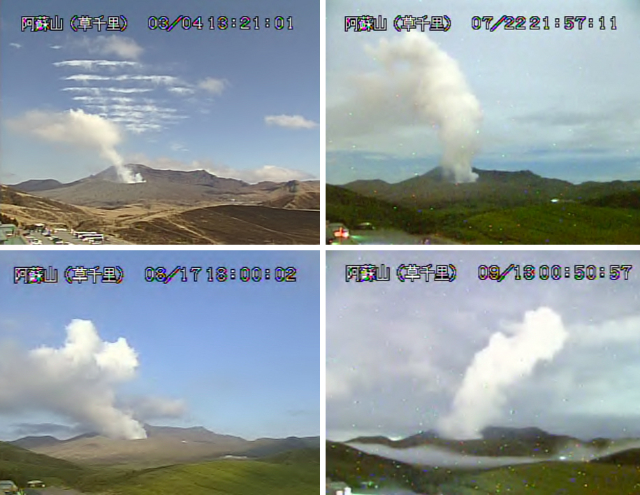 |
Figure 45. Typical steam plumes at Asosan during 2018 rose around 500 m above the Nakadake Crater 1. Images are from 4 March (top left), 22 July (top right), 17 August (lower left), and 13 September 2018 (lower right). Courtesy of JMA (Aso volcano monthly activity reports, Fukuoka District Meteorological Observatory, Regional volcano monitoring and warning center). |
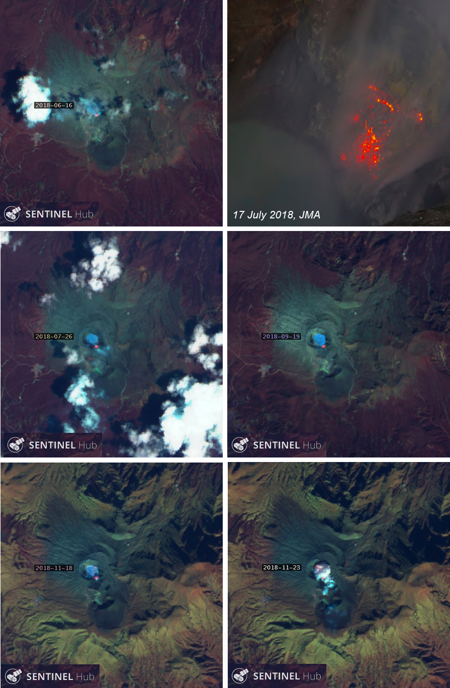 |
Figure 46. Nighttime incandescence was reported by JMA during May-October 2018 from the S rim of Nakadake Crater 1 at Asosan; Sentinel-2 satellite images (bands 12, 4, 2) captured thermal anomalies from the same area numerous times during 2018 including on 16 June (top left), 26 July and 19 September (middle row), and 18 and 23 November (bottom row). JMA photographed incandescence at night on 17 July 2018 at the S fumarole area (top right). Courtesy of Sentinel Hub Playground and JMA (Aso volcano Monthly Report for July 2018). |
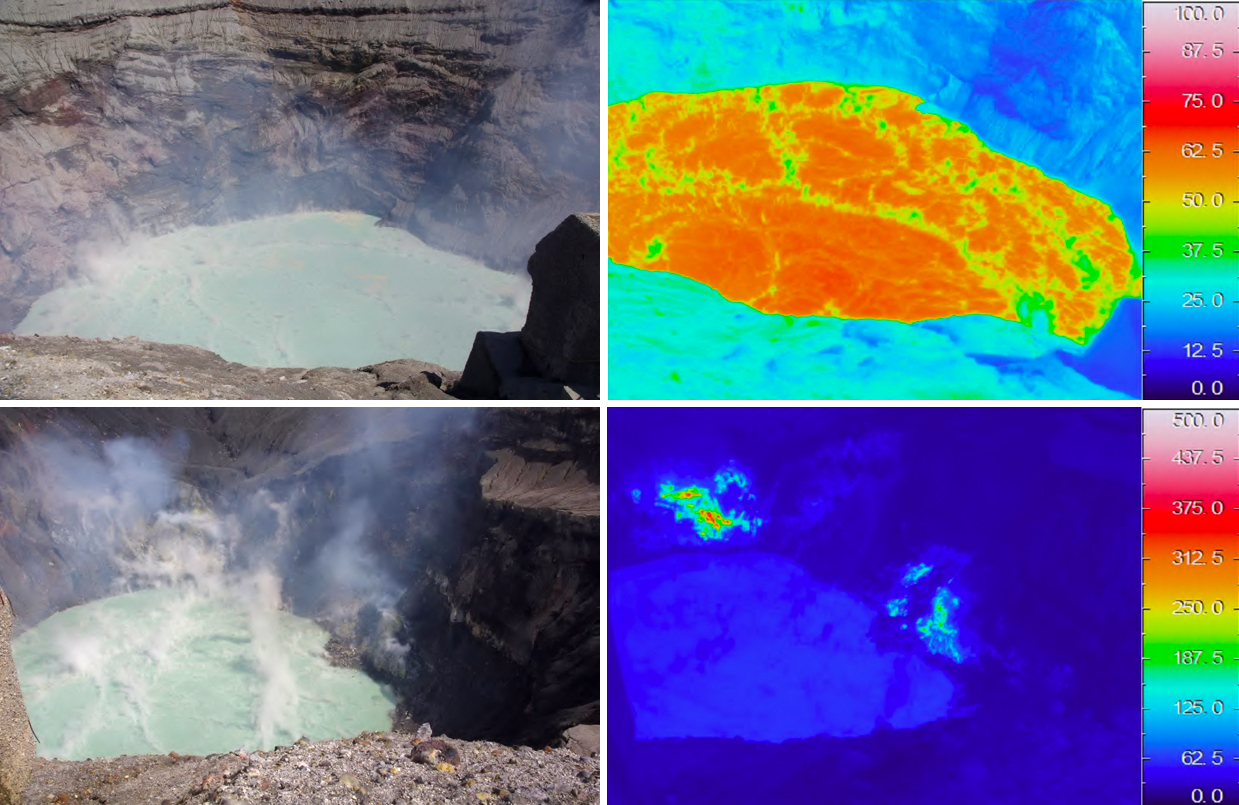 |
Figure 47. The "Green Tea Pond" inside Nakadake Crater 1 at Asosan had temperatures that ranged from 58 to 75°C during 2018 (top row, 26 March 2018); the thermal anomaly on the S wall of the crater consistently had temperatures measured in the 300-500°C range and the SW fumarole area had somewhat lower temperatures (bottom row, 22 June 2018). Courtesy of JMA (monthly Asosan reports for March, May, and June 2018). |
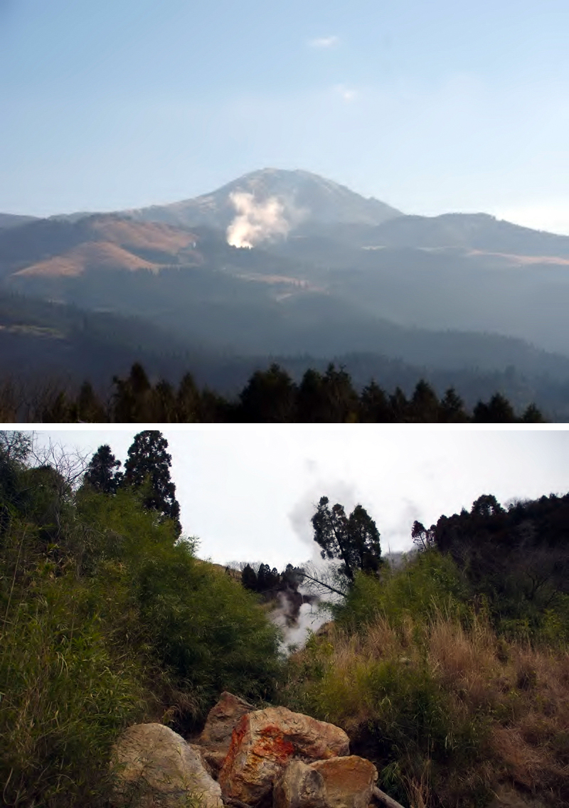 |
Figure 48. The Minami Aso village Yoshioka fumarole zone, located about 5 km W of Nakadake Crater 1 at Asosan, continued to produce modest steam plumes throughout 2017 and 2018. It is shown here on 20 December 2017 (top) and 12 March 2018 (bottom). Courtesy of JMA (December 2017 and March 2018 monthly volcano reports). |
Activity during January-June 2019. Steam plumes rose to 800 m above the crater rim during January 2019. Overall activity increased slightly during February; SO2 emissions peaked at 2,200 t/d early in the month; they ranged from 800 to 1,800 t/d for most of the month. The amplitude of volcanic tremor also increased slightly during February. A further increase in tremor amplitude on 11 March 2019 prompted JMA to raise the Alert Level from 1 to 2 the following morning. Volcanic tremor amplitude decreased on 15 March; JMA determined that activity had decreased, and the Alert Level was lowered back to 1 on 29 March 2019. The amount of water in the crater decreased significantly between 27 February and 20 March, exposing part of the crater floor.
The surface temperature of the lake rose during the first part of 2019; it was 78°C in February and 84°C in March. Steam plumes rose to 1,200 m above the crater rim during March and April. SO2 emissions rose to 4,500 t/d on 12 March but dropped to a lower range of 1,300-2,400 for the rest of the month. Another surge in SO2 emissions on 12 April 2019 to 3,600 t/d prompted a special report from JMA the following day. SO2 emissions varied from about 1,700 to 4,100 t/d during the month; values remained high during the second half of the month. JMA noted that the color of the water in the lake inside Nakadake Crater 1 changed from green to gray after 4 April. Fountains of muddy water were periodically observed; they reached 15 m high on 9 April. The temperatures of both the lake (82°C) and around the two fumarole areas (S area about 530°C, SW area about 310°C) remained constant during April and similar to March.
A large increase in the amplitude of volcanic tremor early on 14 April 2019 prompted JMA to raise the Alert Level from 1 to 2 later in the day. The epicenters of the earthquakes were very shallow, located within 1 km beneath the crater. A small eruption occurred at 1828 on 16 April at Nakadake Crater 1; it produced a gray and white plume that rose 200 m above the crater rim and was the first eruption since 8 October 2016 (figure 49). Incandescence was observed inside the crater on 3 and 17 April. The amplitude of seismic tremors decreased on 18 April. Three very small eruptions on 19 April produced ash and steam plumes that rose 500 m above the crater rim. During a site visit that day JMA measured a high-temperature area that produced incandescence from the bottom of the crater at night (figure 50).
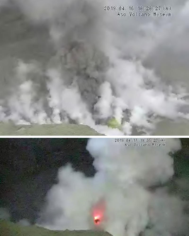 |
Figure 49. The first eruption since October 2016 at Nakadake Crater 1 at Asosan on 16 April 2019 sent an ash plume 200 m above the crater rim (top). Incandescent gas appeared on the crater floor the next day (bottom). Courtesy of JMA (Aso volcano monthly activity reports, April 2019, Fukuoka District Meteorological Observatory, Regional volcano monitoring and warning center). |
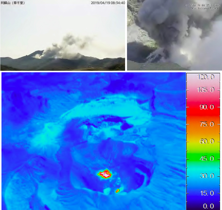 |
Figure 50. Three small explosions on 19 April 2019 at Asosan's Nakadake Crater 1 produced small ash emissions that rose 500 m above the crater rim (top). A strong thermal signal also appeared from the bottom of the crater. Courtesy of JMA (Aso volcano monthly activity reports, April 2019, Fukuoka District Meteorological Observatory, Regional volcano monitoring and warning center). |
A new eruption began at 1540 on 3 May that lasted until 0620 on 5 May (figure 51). Initially the ash plume rose 600 m above the crater rim, but a few hours later the volume of ash increased, and the plume reached 2 km above the crater rim for a brief period. Incandescence was visible from the webcam. The Tokyo VAAC reported the ash plume at 3 km altitude drifting SE on 3 May. Later in the day it rose to 3.7 km altitude and drifted SW. During a field survey the following day (4 May) JMA reported a steam and ash plume rising from the center of the active crater. The infrared thermal imaging camera recorded the temperature of the plume at about 500°C (figure 52).
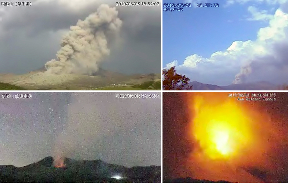 |
Figure 51. An explosion at Asosan's Nakadake Crater 1 on 3 May 2019 produced an ash plume that reached 2 km above the crater rim (top) and incandescence visible from the webcam (bottom). Courtesy of JMA (Aso volcano monthly activity reports, April 2019, Fukuoka District Meteorological Observatory, Regional volcano monitoring and warning center). |
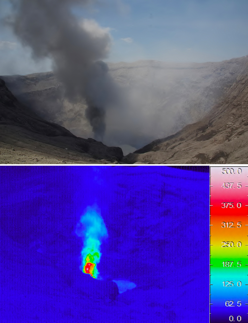 |
Figure 52. During a site visit on 4 May 2019, staff from JMA witnessed an ash and steam plume rising from the bottom of Nakadake Crater 1 at Asosan (top). The infrared thermal imaging camera recorded the temperature of the plume at about 500°C (bottom). Courtesy of JMA (Aso volcano monthly activity reports, May 2019, Fukuoka District Meteorological Observatory, Regional volcano monitoring and warning center). |
Ash fell on the S flank, and a small amount of ashfall on 4 May was confirmed by evidence on a car windshield in Takamori Town (6 km S), Kumamoto Prefecture (figure 53). Ashfall was also reported in Takamori-machi, Minami Aso village (9 km SW), and part of Yamato-cho (25 km SW), also in the Kumamoto Prefecture. SO2 emissions were measured as high as 4,000 t/d on 4 May. Additional explosions with ash plumes were reported from Asosan on 9, 12-16, 29, and 31 May; the plumes rose from 200 to 1,400 m above the crater rim but were not visible in satellite imagery. The TROPOMI instrument on the Sentinel-5 satellite captured SO2 plumes on 3 and 26 May 2019 (figure 54).
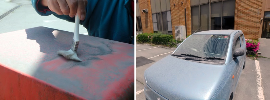 |
Figure 53. Ashfall was reported on 4 May 2019 in Takamori Town, Kumamoto Prefecture, from the eruption at Asosan's Nakadake Crater 1 on 3 May 2019. Courtesy of JMA (Aso volcano monthly activity reports, May 2019, Fukuoka District Meteorological Observatory, Regional volcano monitoring and warning center). |
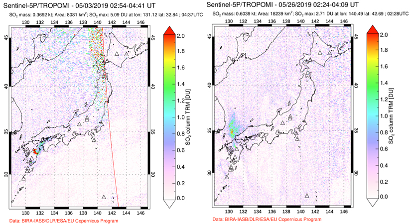 |
Figure 54. Plumes of SO2 from Asosan were recorded by the TROPOMI instrument on the Sentinel-5P satellite on 3 (left) and 26 (right) May 2019. Courtesy of NASA Goddard Space Flight Center. |
Steam plumes rose to 1,700 m above the crater rim during June 2019 (figure 55). During field visits on 6 and 25 June diffuse ash emissions were observed rising from the center of the active crater, but they did not extend significantly above the crater rim (figure 56). The maximum temperature of the plume was measured at about 340°C with a thermal imaging camera. Almost all of the water in the crater bottom had evaporated since early May; incandescence continued to be observed within the crater at night with the high-resolution webcam (figure 57).
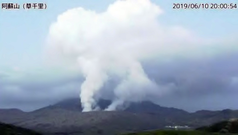 |
Figure 55. Steam plumes rose to 1,700 m above the crater rim at Asosan's Nakadake Crater 1 on 10 June 2019. Courtesy of JMA (Aso volcano monthly activity reports, June 2019, Fukuoka District Meteorological Observatory, Regional volcano monitoring and warning center). |
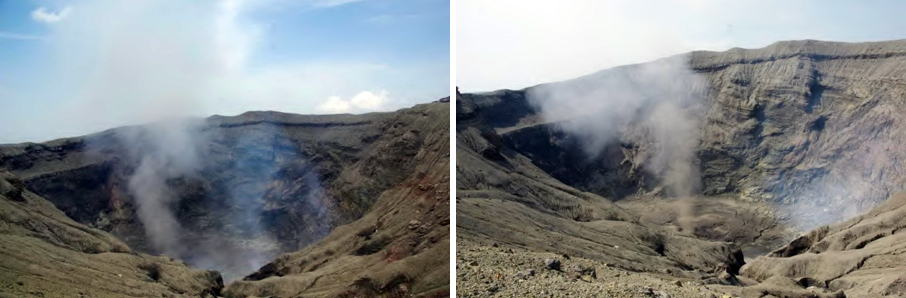 |
Figure 56. Plumes of gas and minor ash were visible at Asosan's Nakadake Crater 1 during site visits by JMA on 6 (left) and 25 (right) June 2019. Courtesy of JMA (Aso volcano monthly activity reports, June 2019, Fukuoka District Meteorological Observatory, Regional volcano monitoring and warning center). |
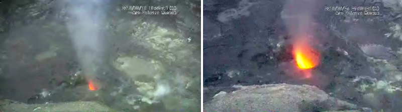 |
Figure 57. Incandescent gas was visible from the vent at Asosan's Nakadake Crater 1 on 18 (left) and 25 (right) June 2019. Courtesy of JMA (Aso volcano monthly activity reports, June 2019, Fukuoka District Meteorological Observatory, Regional volcano monitoring and warning center). |
Information Contacts: Japan Meteorological Agency (JMA), Otemachi, 1-3-4, Chiyoda-ku Tokyo 100-8122, Japan (URL: http://www.jma.go.jp/jma/indexe.html); Tokyo Volcanic Ash Advisory Center (VAAC), 1-3-4 Otemachi, Chiyoda-ku, Tokyo, Japan (URL: http://ds.data.jma.go.jp/svd/vaac/data/); Sentinel Hub Playground (URL: https://www.sentinel-hub.com/explore/sentinel-playground); Global Sulfur Dioxide Monitoring Page, Atmospheric Chemistry and Dynamics Laboratory, NASA Goddard Space Flight Center (NASA/GSFC), 8800 Greenbelt Road, Goddard, Maryland, USA (URL: https://so2.gsfc.nasa.gov/).
Intermittent ash plumes and elevated SO2 emissions continue during July-December 2019
The large Asosan caldera reaches around 23 km long in the N-S direction and contains a complex of 17 cones, of which Nakadake is the most active (figure 58). A recent increase in activity prompted an alert level increase from 1 to 2 on 14 April 2019. The Nakadake crater is the site of current activity (figure 59) and contains several smaller craters, with the No. 1 crater being the main source of activity during July-December 2019. The activity during this period is summarized here based on reports by the Japan Meteorological Agency and satellite data.
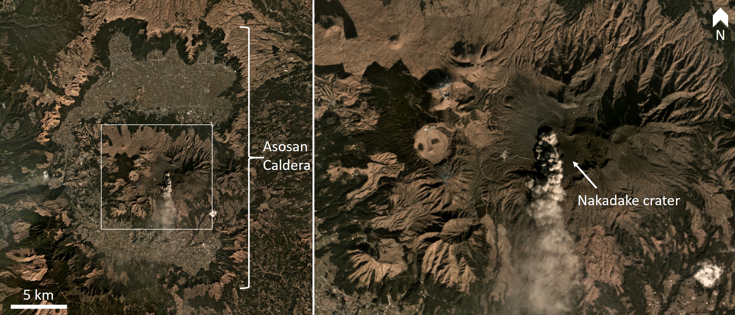 |
Figure 58. Asosan is a group of cones and craters within a larger caldera system. January 2010 Monthly Mosaic images copyright Planet Labs 2019. |
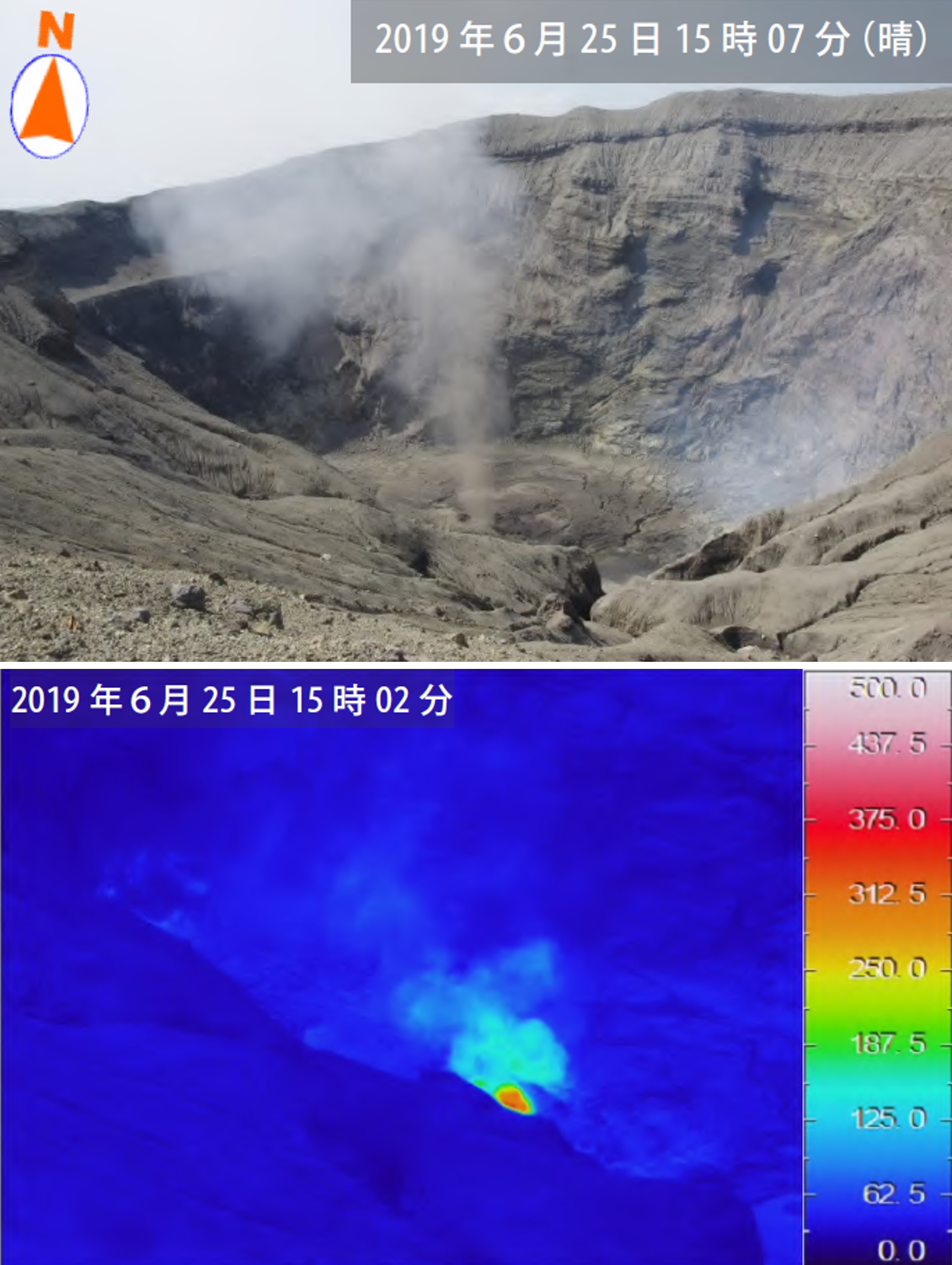 |
Figure 59. Hot gas emissions from the Nakadake No. 1 crater on 25 June 2019 reached around 340°C. Courtesy of the Japan Meteorological Agency (July 2019 monthly report). |
Small explosions were observed at the No. 1 vent on the 4, 5, 9, 13-16, and 26 July. There was an increase in thermal energy detected near the vent leading to a larger event on the 26th (figures 60 and 61), which produced an ash plume up to 1.6 km above the crater rim and continuing from 0757 to around 1300 with a lower plume height of 400 m after 0900. Light ashfall was reported downwind. Elevated activity was noted during 28-29 July, and an ash plume was seen in webcam footage on the 30th. Incandescence was visible in light-sensitive cameras during 4-17 and after the 26th. A field survey on 5 July measured 1,300 tons of sulfur dioxide (SO2) per day. This had increased to 2,300 tons per day by the 12th, 2,500 on the 24th, and 2,400 by the 25th. A sulfur dioxide plume was detected in Sentinel-5P/TROPOMI satellite data acquired on 28 July (figure 62).
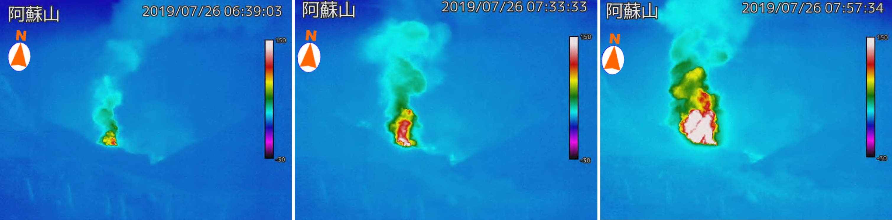 |
Figure 60. Thermal images taken at Asosan on 26 July 2019 show the increasing temperature of emissions leading to an explosion. Courtesy of the Japan Meteorological Agency (July 2019 monthly report). |
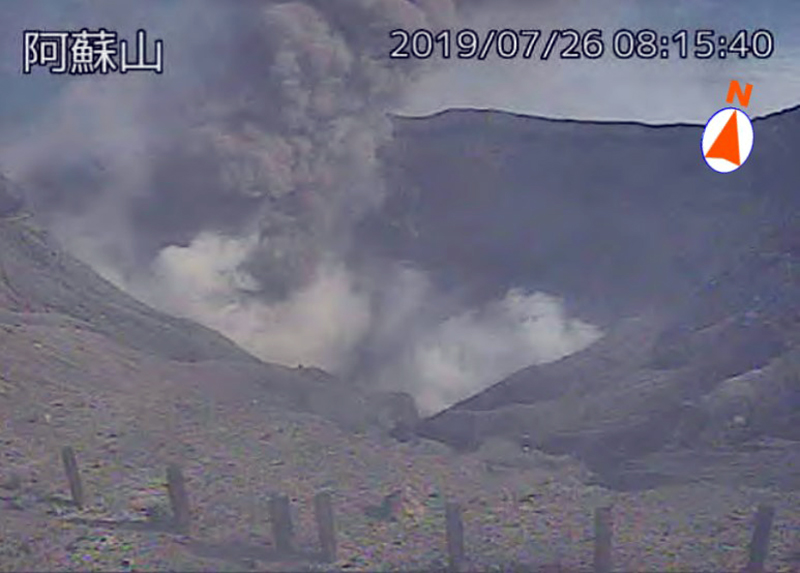 |
Figure 61. An eruption from the Nakadake crater at Asosan on 26 July 2019. Courtesy of the Japan Meteorological Agency (July 2019 monthly report). |
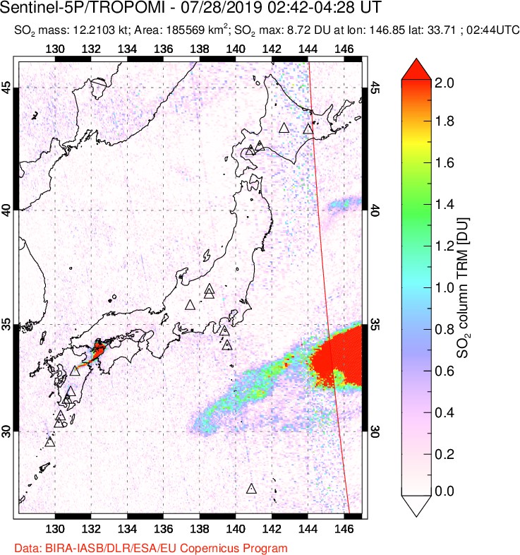 |
Figure 62. A sulfur dioxide plume was detected from Asosan (to the left) on 28 July 2019. The larger plume (red) to the right is not believed to be associated with volcanism in this area. NASA Sentinel-5P/TROPOMI satellite image courtesy of the NASA Goddard Space Flight Center. |
The increased eruptive activity that began on 5 July continued to 16 August. There were 24 eruptions recorded throughout the month, with eruptions occurring on 18-23, 25, and 29-31 August. An ash plume at 2100 on 4 August reached 1.5 km above the crater rim. Detected SO2 increased to extremely high levels from late July to early August with 5,200 tons per day recorded on 9 August, but which then reduced to 2,000 tons per day. Ashfall occurred out to around 7 km NW on the 10th (figure 63). Activity continued to increase at the Nakadake No. 1 crater, producing incandescence. High-temperature gas plumes were detected at the No. 2 crater.
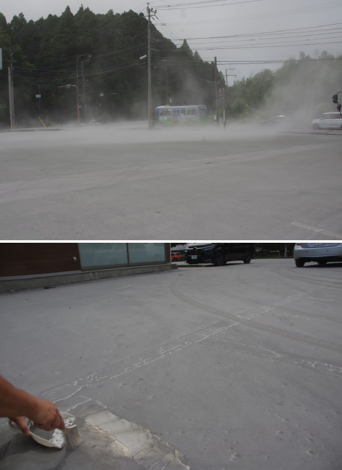 |
Figure 63. Ashfall from Asosan on 10 August 2019 near Otohime, Aso city, which is about 7 km NW of the Nakadake No. 1 crater that produced the ash plume. The ashfall was thick enough that the white line in the parking lot was mostly obscured (lower photo). Courtesy of the Japan Meteorological Agency (August 2019 monthly report). |
Thermal activity continued to increase, and incandescence was observed at the No. 1 crater throughout September. There were 24 eruptions recorded throughout August. Light ashfall occurred out to around 8 km NE on the 3rd and ash plumes reached 1.6 km above the crater rim during 10-13, and again during 25-30 (figures 64 and 65). During the later dates ashfall was reported to the NE and NW. The SO2 levels were back down to 1,600 tons per day by 11 September and increased to 2,600 tons per day by the 26th.
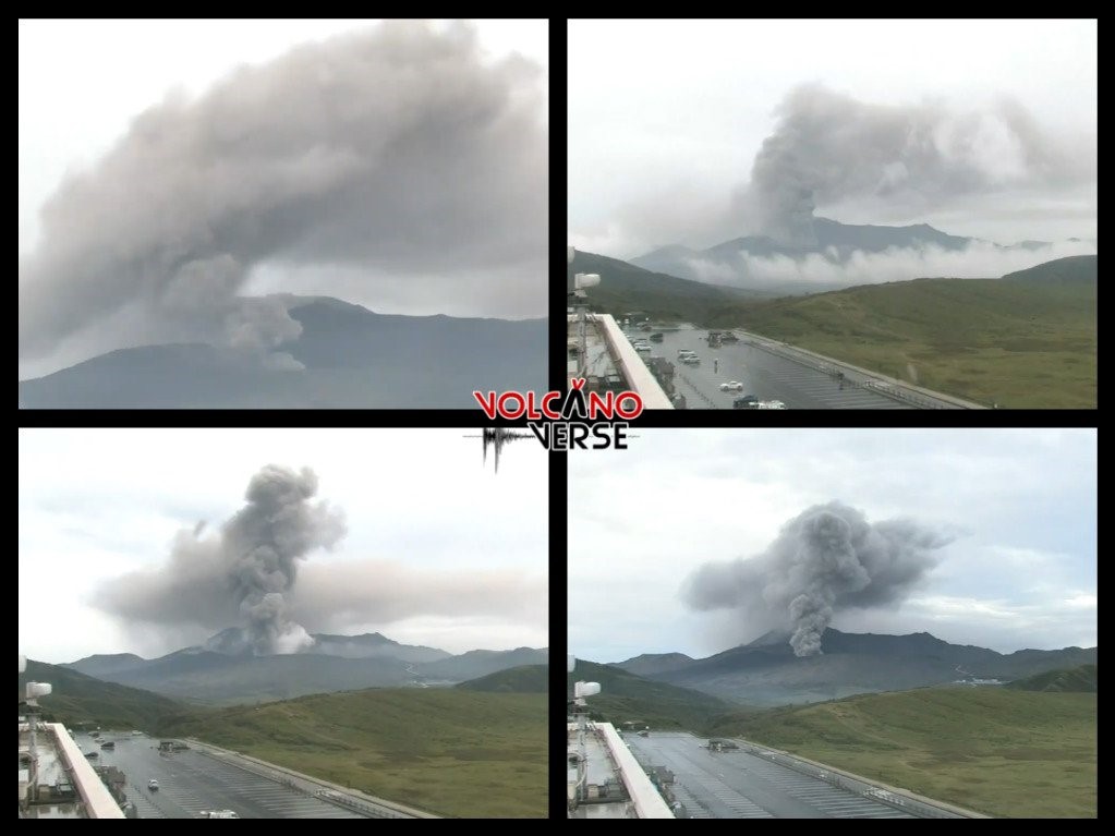 |
Figure 64. Ash plumes at Asosan on 29 September 2019. Courtesy of Volcanoverse. |
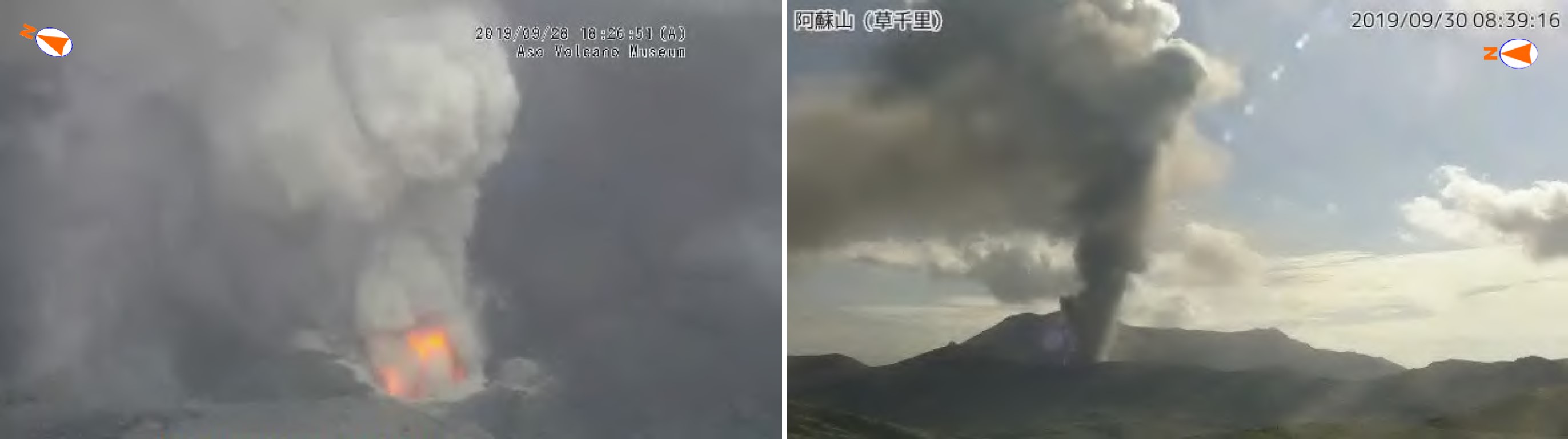 |
Figure 65. Activity at Asosan in late September 2019. Left: incandescence and a gas plume at the Nakadake No. 1 crater on the 28th. Right: an eruption produced an ash plume at 0839 on the 30th. Aso Volcano Museum surveillance camera image (left) and Kusasenri surveillance camera image (right) courtesy of the Japan Meteorological Agency (September 2019 monthly report). |
Similar elevated activity continued through October with ash plumes reaching 1.3 km above the crater and periodic ashfall reported at the Kumamoto Regional Meteorological Observatory, and out to 4 km S to SW on the 19th and 29th. Temperatures up to 580°C were recorded at the No. 1 crater on 23 October and incandescence was occasionally visible at night through the month (figure 66). Gas surveys detected 2,800 tons per day of SO2 on 7 October, which had increased to 4,000 tons per day by the 11th.
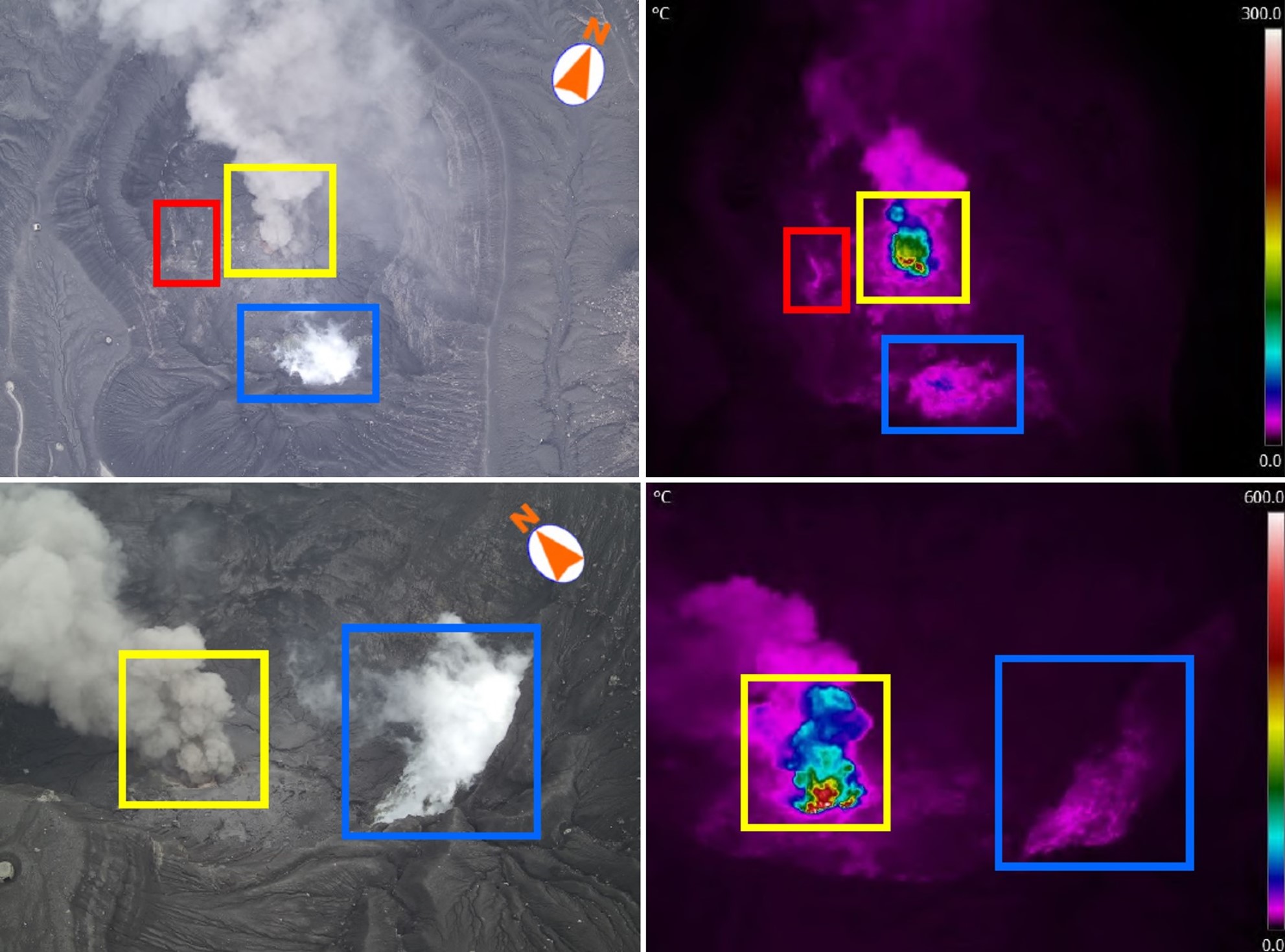 |
Figure 66. Drone images of the Asosan Nakadake crater area on 23 October 2019. The colored boxes show the same vents and the photographs on the left correlate to the thermal images on the right. The yellow box is around the No. 1 crater, with temperature measurements reaching 580°C. The emissions in the red box reached 50°C, and up to 100°C on the southwest crater wall (blue box). Courtesy of the Japan Meteorological Agency (October 2019 monthly report). |
Ash plume emission continued through November (figure 67 and 68). Plumes reached 1.5 to 2.4 km above sea level during 13-18 November and ashfall occurred downwind, with a maximum of 1.4 km above the crater rim for the month. Ashfall was reported near Aso City Hall on the 27th. Incandescence was observed until 6 November. During the first half of October sulfur dioxide emissions were slightly lower than the previous month, with measurements detecting under 3,000 tons per day. In the second half of the month emissions increased to 2,000 to 6,300 tons per day. This was accompanied by an increase in volcanic tremor.
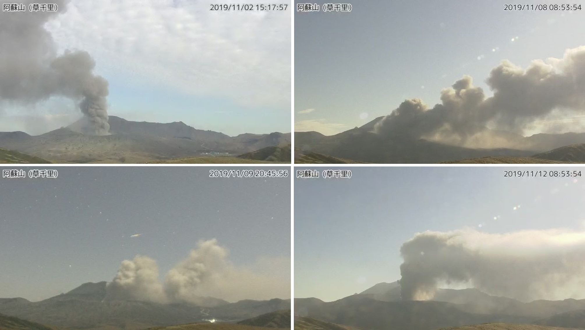 |
Figure 67. Examples of ash plumes at Asosan on 2, 8, 9, and 11 November 2019. The plume on 2 November reached 1.3 km above the crater rim. Kusasenri surveillance camera images courtesy of the Japan Meteorological Agency. |
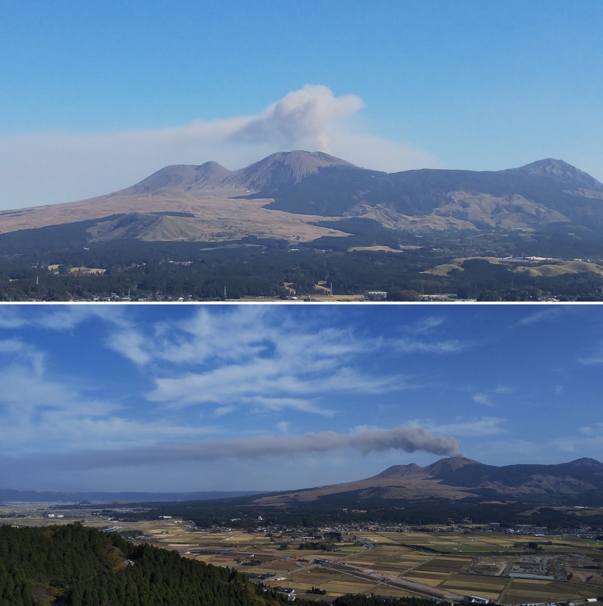 |
Figure 68. Ash emissions from the Nakadake crater at Asosan on 15 and 17 November 2019. The continuous ash emission is weak and is being dispersed by the wind. Copyright Mizumoto, used with permission. |
Throughout December activity remained elevated with ash plumes reaching 1.1 km above the Nakadake No. 1 crater and producing ashfall. The maximum gas plume height was 1.8 km above the crater. A total of 23 eruptions were recorded, and incandescence at the crater was observed through the month. Sulfur dioxide emissions continued to increase with 5,800 tons per day recorded on the 27th, and 7,400 tons per day recorded on the 31st.
Overall, eruptive activity has continued intermittently since 26 July and SO2 emissions have increased through the year. Incandescence was seen at the crater since 2 October and this is consistent with an increase in thermal energy detected by the MIROVA algorithm around that time (figure 69).
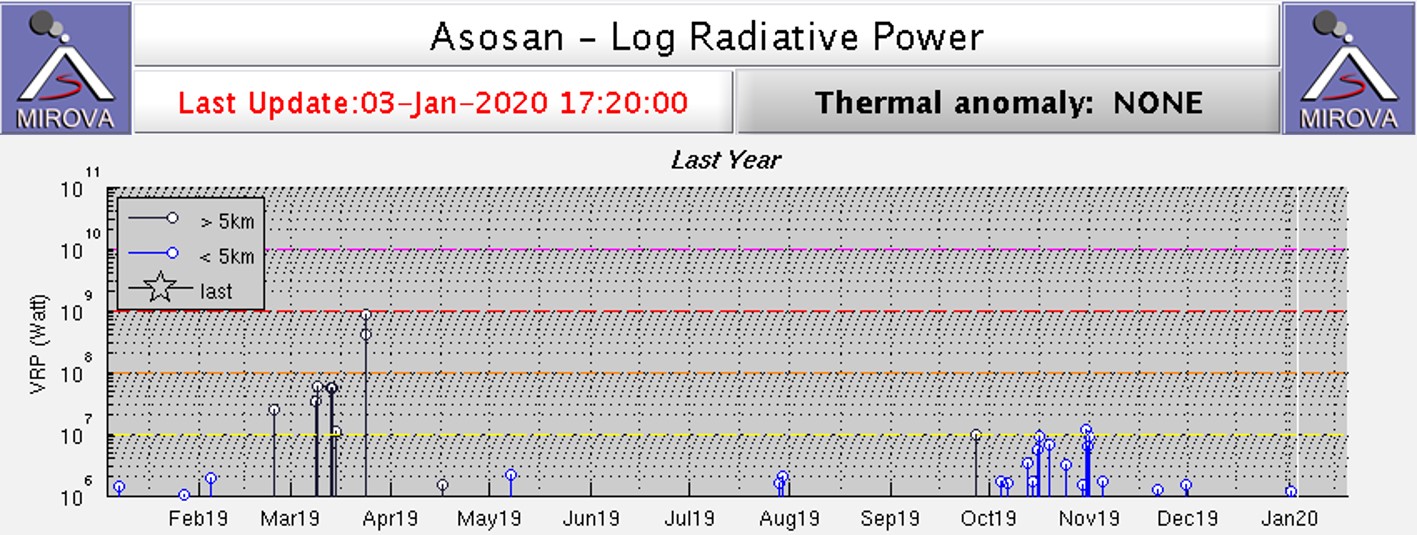 |
Figure 69. Thermal anomalies were low through 2019 with a notable increase around October to November. Log radiative power plot courtesy of MIROVA. |
Information Contacts: Japan Meteorological Agency (JMA), 1-3-4 Otemachi, Chiyoda-ku, Tokyo 100-8122, Japan (URL: http://www.jma.go.jp/jma/indexe.html); Global Sulfur Dioxide Monitoring Page, Atmospheric Chemistry and Dynamics Laboratory, NASA Goddard Space Flight Center (NASA/GSFC), 8800 Greenbelt Road, Goddard, Maryland, USA (URL: https://so2.gsfc.nasa.gov/); MIROVA (Middle InfraRed Observation of Volcanic Activity), a collaborative project between the Universities of Turin and Florence (Italy) supported by the Centre for Volcanic Risk of the Italian Civil Protection Department (URL: http://www.mirovaweb.it/); Planet Labs, Inc. (URL: https://www.planet.com/); Mizumoto, Kumamoto, Kyushu, Japan (Twitter: https://twitter.com/hepomodeler); Volcanoverse (URL: https://www.youtube.com/channel/UCi3T_esus8Sr9I-3W5teVQQ).
Daily ash emissions continue through mid-June 2020 when activity decreases
Japan's 24-km-wide Asosan caldera on the island of Kyushu has been active throughout the Holocene. Nakadake has been the most active of 17 central cones for 2,000 years; all historical activity is from Nakadake Crater 1. The largest ash plume in 20 years occurred on 8 October 2016. Asosan remained quiet until renewed activity from Crater 1 began in mid-April 2019; explosions with ash plumes continued through the first half of 2020 and are covered in this report. The Japan Meteorological Agency (JMA) provides monthly reports of activity; the Tokyo Volcanic Ash Advisory Center (VAAC) issues aviation alerts reporting on possible ash plumes, and Sentinel-2 satellite images provide data on ash emissions and thermal activity.
The Tokyo VAAC issued multiple daily reports of ash plumes from Nakadake Crater 1 from 1 January-14 June 2020. They were commonly at 1.8-2.1 km altitude, and often drifted E or S. JMA reported that ashfall continued downwind from the ash plumes until mid-June; seismic activity was relatively high during January and February and decreased steadily after that time. The measured SO2 emissions ranged from 1,000-4,900 tons per day through mid-June and dropped to 500 tons per day during the second half of June. Intermittent thermal activity was recorded at the crater through mid-May.
Explosive activity during January-June 2020. Ash plumes rose up to 1.1 km above the crater rim at Nakadake Crater 1 during January 2020 (figure 70). Ashfall was confirmed downwind of an explosion on 7 January. During February, ash plumes rose up to 1.7 km above the crater, and ashfall was again reported downwind. The crater camera provided by the Aso Volcano Museum occasionally observed incandescence at the floor of the crater during both months. Incandescence was also occasionally observed with the Kusasenri webcam (3 km W) and was seen on 20 February from a webcam in Minamiaso village (8 km SW).
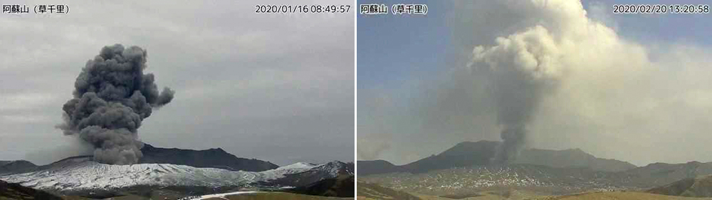 |
Figure 70. Ash plumes rose up to 1.1 km above the Nakadake Crater 1 at Asosan during January 2020 (left) and up to 1.7 km above the crater during February 2020 (right) as seen in these images from the Kusasenri webcam. Ashfall was reported downwind multiple times. Courtesy of JMA (Volcanic activity commentary material for Mt. Aso, January and February 2020). |
During March 2020, ash plumes rose as high as 1.3 km. Ashfall was reported on 9 March in Ichinomiyamachi, Aso City (figure 71). In field surveys conducted on the 18th and 25th, there was no visible water inside the crater, and high-temperature grayish-white plumes were observed. The temperature at the base of the plume was measured at 300°C (figure 72).
 |
Figure 71. Ashfall from Asosan appeared on 9 March 2020 in Ichinomiyamachi, Aso City around 10 km N. Courtesy of JMA (Volcanic activity commentary material for Mt. Aso, March 2020). |
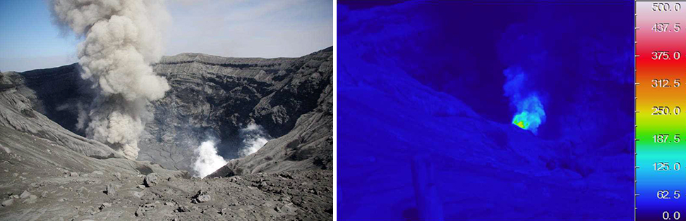 |
Figure 72. During a field survey of Nakadake Crater 1 at Asosan on 25 March 2020, JMA staff observed a gray ash plume rising from the crater floor (left). The maximum temperature of the ash plume was measured at about 300°C with an infrared thermal imaging device (right). Courtesy of JMA (Volcanic activity commentary material for Mt. Aso, March 2020). |
Occasional incandescence was observed at the bottom of the crater during April and May 2020; ash plumes rose 1.1 km above the crater on most days in April and were slightly higher, rising to 1.8 km during May, although activity was more intermittent (figure 73). A brief increase in SO2 activity was reported by JMA during field surveys on 7 and 8 May; satellite data captured small plumes of SO2 on 1 and 6 May (figure 74). A brief increase in tremor amplitude was reported by JMA on 16 May.
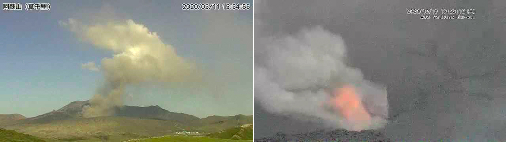 |
Figure 73. Although activity at Asosan’s Nakadake Crater 1 was more intermittent during April and May 2020 than earlier in the year, ash plumes were still reported most days and incandescence was seen at the bottom of the crater multiple times until 15 May. Left image taken 11 May 2020 from the Kusachiri webcam; right image taken from the crater webcam on 10 May provided by the Aso Volcano Museum. Courtesy of JMA (Volcanic activity commentary material for Mt. Aso, May 2020). |
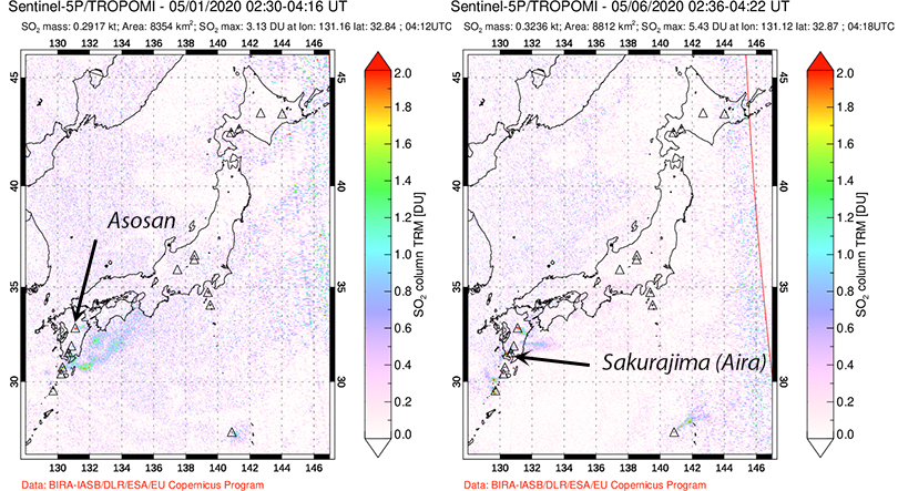 |
Figure 74. The TROPOMI instrument on the Sentinel-5P satellite detected small but distinct SO2 plumes from Asosan on 1 and 6 May 2020. Additional small plumes are visible from Aira caldera’s Sakurajima volcano. Courtesy of NASA’s Global Sulfur Dioxide Monitoring Page. |
The last report of ash emissions at Nakadake Crater 1 from the Tokyo VAAC was on 14 June 2020. JMA also reported that no eruption was observed after mid-June. On 8 June they reported an ash plume that rose 1.4 km above the crater. During a field survey on 16 June, only steam was observed at the crater; the plume rose about 100 m (figure 75). In addition, a small plume of steam rose from a fumarole on the S crater wall.
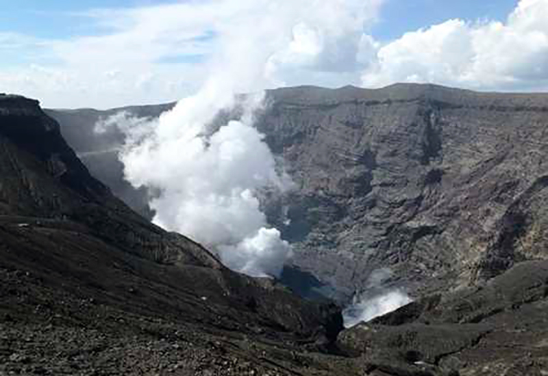 |
Figure 75. A steam plume rose about 100 m from the floor of Nakadake Crater 1 on 16 June 2020. A small steam plume was also observed by the S crater wall. Courtesy of JMA (Volcanic activity commentary material for Mt. Aso, June 2020). |
Thermal activity during January-June 2020. Sentinel-2 satellite data indicated thermal anomalies present at Nakadake Crater 1 on 2 January, 6 and 21 February, 16 April, and 11 May (figure 76). In addition, thermal anomalies from agricultural fires appeared in satellite images on 11 February, 7 and 17 March (figure 77). The fires were around 5 km from the crater, thus they appear on the MIROVA thermal anomaly graph in black, but are likely unrelated to volcanic activity (figure 78). No thermal anomalies were recorded in satellite data from the Nakadake Crater 1 after 11 May, and none appeared in the MIROVA data as well.
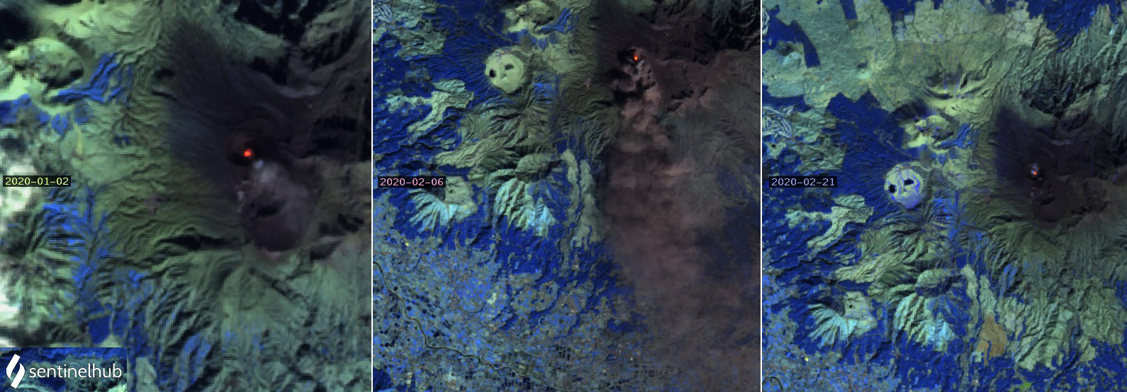 |
Figure 76. Thermal anomalies appeared at Asosan’s Nakadake Crater 1 on 2 January, 6 and 21 February, 16 April and 11 May 2020. On 2 January a small ash plume drifted SSE from the crater (left). On 6 February a dense ash plume drifted S from the crater (center). Only a small steam plume was visible above the crater on 21 February (right). Images use Atmospheric penetration rendering (bands 12, 11, 8A), courtesy of Sentinel Hub Playground. |
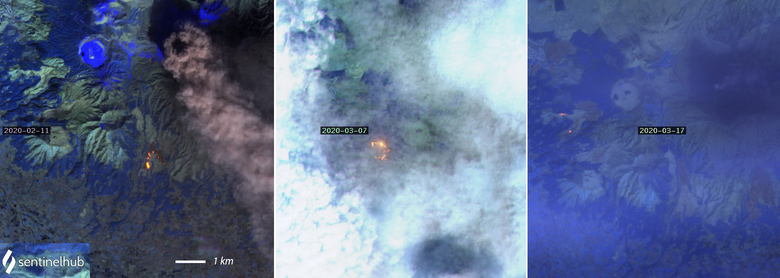 |
Figure 77. Thermal anomalies from agricultural fires located about 5 km from the crater appeared in satellite images on 11 February, and 7 and 17 March 2020. Although a dense ash plume drifted SSE from the crater on 11 February (left), no thermal anomalies appear at the crater on these dates. Images use Atmospheric penetration rendering (bands 12, 11, 8A), courtesy of Sentinel Hub Playground. |
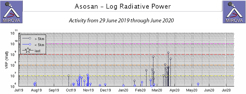 |
Figure 78. The MIROVA project plot of Log Radiative Power at Asosan from 29 June 2019 through June 2020 shows only a few small thermal alerts within 5 km of the summit crater during January-June 2020, and a spike in activity during February and March located around 5 km away. These data correlate well with the Sentinel-2 satellite data that show intermittent thermal anomalies at the summit throughout January-May and agricultural fires located several kilometers from the crater during February and March. Courtesy of MIROVA. |
Information Contacts: Japan Meteorological Agency (JMA), 1-3-4 Otemachi, Chiyoda-ku, Tokyo 100-8122, Japan (URL: http://www.jma.go.jp/jma/indexe.html); Global Sulfur Dioxide Monitoring Page, Atmospheric Chemistry and Dynamics Laboratory, NASA Goddard Space Flight Center (NASA/GSFC), 8800 Greenbelt Road, Goddard, Maryland, USA (URL: https://so2.gsfc.nasa.gov/); MIROVA (Middle InfraRed Observation of Volcanic Activity), a collaborative project between the Universities of Turin and Florence (Italy) supported by the Centre for Volcanic Risk of the Italian Civil Protection Department (URL: http://www.mirovaweb.it/); Sentinel Hub Playground (URL: https://www.sentinel-hub.com/explore/sentinel-playground).
Ash explosions during 14-20 October 2021; plume to 3.5 km height and a pyroclastic flow
Asosan, on Japan’s southern island of Kyushu, is among the largest calderas in the world and one of Japan’s most active volcanoes. Among the group of 17 central cones, Nakadake is currently the most active. During April 2019, Nakadake entered an eruptive period, with ash explosions and emissions, elevated sulfur dioxide (SO2) levels, and intermittent thermal activity and incandescence. Elevated activity continued until 14 June 2020, after which the volcano entered a quiet stage with only gas emissions (BGVN 45:01, 45:07). The volcano is monitored by the Japan Meteorological Agency (JMA) and by satellites. This report discusses activity between 1 July 2020 and 31 December 2021.
Based on JMA reports, no explosions were recorded after mid-June 2020 until 14 October 2021. The only observed activity was white plumes that rose as high as 1 km above the crater. SO2 emissions decreased, and volcanic-tremor amplitude decreased to low levels on 18 July. During a field inspection on 17 August 2020 there was no water in the crater. Volcanic tremor amplitude increased on 2 May 2021 at 2100. SO2 emissions were low, at 200 metric tons/day on 3 May, and white steam plumes rose as high as 300 m above the crater rim. The amplitude remained high through 10 May and then gradually decreased.
JMA reported that tremor signals resumed on 12 October 2021; amplitude began increasing at 1530 on 13 October. White plumes rose 1.4 km above Nakadake Crater. On 14 October an explosion was detected at 0443; weather clouds prevented visual confirmation of a plume, though ejected incandescent material was visible in thermal camera images. During a field visit later that day, scientists confirmed ashfall in several areas, including parts of Takamori Town (7 km SSW of Nakadake crater), Taketa City (29 km ENE), and Takachiho Town (28 km SE). Weak explosions occurred on 15 October at 1057 and 1325. Volcanic tremor amplitude increased at 1400 on 18 October. During an overflight, scientists observed ash deposits extending SE from Nakadake Crater. Volcanic tremor amplitude continued to fluctuate at high levels on 19 October.
At 1143 on 20 October an explosion ejected blocks 900 m S and produced an ash plume that rose 3.5 km above the crater rim and drifted E (figures 79-81). Pyroclastic flows descended 1.3 km W. Very small explosions were recorded during 1244-1410. One news source (The Japan Times) stated that all 16 climbers on the volcano at the time of the explosion returned safely. That same source reported that on the following day, a street-sweeping truck in Takamori began to clear several dozen tons of ash. On 21 October, the SO2 emission rate was high at 2,500 metric tons/day (t/d), but lower than the rate during the previous day of 4,400 t/d. During 21-22 October, white plumes rose 900 m from the crater.
|
Figure 79. Aerial view of that explosion at Asosan on 20 October 2021. Courtesy of Kyodo News. |
|
Figure 80. Photo of the 20 October 2021 explosion at Asosan taken from a helicopter. The Aso Volcano Museum is at the bottom of the image. Courtesy of Kyodo News. |
|
Figure 81. Ash explosion at Asosan on 20 October 2021. Photo by @NINJA250_NBYK. |
On 18 November JMA lowered the Alert Level to 2 and decreased the restricted area to a radius of 1 km, noting that no explosions had been recorded since 20 October. The amplitudes of volcanic microtremors fluctuated for a period after the explosion, though they were generally small beginning on 1 November. A field survey by JMA on 16 November had found that the SO2 emission was still high at 2,100 t/d, and it remained elevated through the end of the year. No further explosions were recorded through the end of the year.
Information Contacts: Japan Meteorological Agency (JMA), 1-3-4 Otemachi, Chiyoda-ku, Tokyo 100-8122, Japan (URL: http://www.jma.go.jp/jma/indexe.html); Kyodo News (URL: https://english.kyodonews.net/); The Japan Times (URL: https://www.japantimes.co.jp/); Twitter User @NINJA250_NBYK (URL: https://twitter.com/NINJA250_NBYK).
|
|
||||||||||||||||||||||||||
There is data available for 172 confirmed eruptive periods.
2021 Oct 14 - 2021 Oct 20 Confirmed Eruption (Explosive / Effusive) VEI: 2
| Episode 1 | Eruption (Explosive / Effusive) | ||||||||||||||||||||||||||||||||||
|---|---|---|---|---|---|---|---|---|---|---|---|---|---|---|---|---|---|---|---|---|---|---|---|---|---|---|---|---|---|---|---|---|---|---|
| 2021 Oct 14 - 2021 Oct 20 | Evidence from Observations: Reported | |||||||||||||||||||||||||||||||||
| An eruption was detected at 0443 on 14 October; ejected incandescent material was visible in thermal camera images. Small eruptive events also occurred on 15 October. On 20 October an eruption ejected blocks 900 m S and produced an ash plume that rose 3.5 km above the crater rim and drifted E. Pyroclastic flows descended 1.3 km W. | ||||||||||||||||||||||||||||||||||
|
List of 5 Events for Episode 1
|
||||||||||||||||||||||||||||||||||
2019 Apr 16 - 2020 Jun 16 Confirmed Eruption (Explosive / Effusive) VEI: 2
| Episode 1 | Eruption (Explosive / Effusive) | ||||||||||||||
|---|---|---|---|---|---|---|---|---|---|---|---|---|---|---|
| 2019 Apr 16 - 2020 Jun 16 | Evidence from Observations: Reported | |||||||||||||
|
List of 1 Events for Episode 1
|
||||||||||||||
2016 Oct 7 - 2016 Nov 12 Confirmed Eruption (Explosive / Effusive) VEI: 3
| Episode 1 | Eruption (Explosive / Effusive) | Nakadake Crater | |||||||||||||||||||||||||||||||||||||||||||||||||||||
|---|---|---|---|---|---|---|---|---|---|---|---|---|---|---|---|---|---|---|---|---|---|---|---|---|---|---|---|---|---|---|---|---|---|---|---|---|---|---|---|---|---|---|---|---|---|---|---|---|---|---|---|---|---|---|
| 2016 Oct 7 - 2016 Nov 12 | Evidence from Observations: Reported | |||||||||||||||||||||||||||||||||||||||||||||||||||||
|
List of 9 Events for Episode 1 at Nakadake Crater
|
||||||||||||||||||||||||||||||||||||||||||||||||||||||
2014 Aug 30 - 2016 May 1 Confirmed Eruption (Explosive / Effusive) VEI: 2
| Episode 1 | Eruption (Explosive / Effusive) | Naka-dake | |||||||||||||||||||||||||||||||||||||||||||||||||||||||||||||||||||||||||||||||||||||||||||||||||||||||||||||||||||||||||||||||||||||||||||||||||||||||||||||||||||||||||||||||||||||||||||||||||||||||||||||||||||||||||||||||||||||||||||||||||||||||||||||||||||||||||||||||||||||||||||||||||||||||||||||||||||||||||||||||||||||||||||||||||||||||||||||||||||||||||||||||||||||||||||||||||||||||||||||||||||||||||||||
|---|---|---|---|---|---|---|---|---|---|---|---|---|---|---|---|---|---|---|---|---|---|---|---|---|---|---|---|---|---|---|---|---|---|---|---|---|---|---|---|---|---|---|---|---|---|---|---|---|---|---|---|---|---|---|---|---|---|---|---|---|---|---|---|---|---|---|---|---|---|---|---|---|---|---|---|---|---|---|---|---|---|---|---|---|---|---|---|---|---|---|---|---|---|---|---|---|---|---|---|---|---|---|---|---|---|---|---|---|---|---|---|---|---|---|---|---|---|---|---|---|---|---|---|---|---|---|---|---|---|---|---|---|---|---|---|---|---|---|---|---|---|---|---|---|---|---|---|---|---|---|---|---|---|---|---|---|---|---|---|---|---|---|---|---|---|---|---|---|---|---|---|---|---|---|---|---|---|---|---|---|---|---|---|---|---|---|---|---|---|---|---|---|---|---|---|---|---|---|---|---|---|---|---|---|---|---|---|---|---|---|---|---|---|---|---|---|---|---|---|---|---|---|---|---|---|---|---|---|---|---|---|---|---|---|---|---|---|---|---|---|---|---|---|---|---|---|---|---|---|---|---|---|---|---|---|---|---|---|---|---|---|---|---|---|---|---|---|---|---|---|---|---|---|---|---|---|---|---|---|---|---|---|---|---|---|---|---|---|---|---|---|---|---|---|---|---|---|---|---|---|---|---|---|---|---|---|---|---|---|---|---|---|---|---|---|---|---|---|---|---|---|---|---|---|---|---|---|---|---|---|---|---|---|---|---|---|---|---|---|---|---|---|---|---|---|---|---|---|---|---|---|---|---|---|---|---|---|---|---|---|---|---|---|---|---|---|---|---|---|---|---|---|---|---|---|---|---|---|---|---|---|---|---|---|---|---|---|---|---|---|---|---|---|---|---|---|---|---|---|---|---|---|---|---|---|---|---|---|---|---|---|---|---|---|
| 2014 Aug 30 - 2016 May 1 | Evidence from Observations: Reported | |||||||||||||||||||||||||||||||||||||||||||||||||||||||||||||||||||||||||||||||||||||||||||||||||||||||||||||||||||||||||||||||||||||||||||||||||||||||||||||||||||||||||||||||||||||||||||||||||||||||||||||||||||||||||||||||||||||||||||||||||||||||||||||||||||||||||||||||||||||||||||||||||||||||||||||||||||||||||||||||||||||||||||||||||||||||||||||||||||||||||||||||||||||||||||||||||||||||||||||||||||||||||||||
|
List of 81 Events for Episode 1 at Naka-dake
|
||||||||||||||||||||||||||||||||||||||||||||||||||||||||||||||||||||||||||||||||||||||||||||||||||||||||||||||||||||||||||||||||||||||||||||||||||||||||||||||||||||||||||||||||||||||||||||||||||||||||||||||||||||||||||||||||||||||||||||||||||||||||||||||||||||||||||||||||||||||||||||||||||||||||||||||||||||||||||||||||||||||||||||||||||||||||||||||||||||||||||||||||||||||||||||||||||||||||||||||||||||||||||||||
2014 Jan 13 - 2014 Feb 19 Confirmed Eruption (Explosive / Effusive) VEI: 1
| Episode 1 | Eruption (Explosive / Effusive) | Naka-dake | ||||||||||||||||||||||||||||||||||||||||||||||||
|---|---|---|---|---|---|---|---|---|---|---|---|---|---|---|---|---|---|---|---|---|---|---|---|---|---|---|---|---|---|---|---|---|---|---|---|---|---|---|---|---|---|---|---|---|---|---|---|---|---|
| 2014 Jan 13 - 2014 Feb 19 | Evidence from Observations: Reported | ||||||||||||||||||||||||||||||||||||||||||||||||
|
List of 8 Events for Episode 1 at Naka-dake
|
|||||||||||||||||||||||||||||||||||||||||||||||||
2011 May 15 - 2011 Jun 9 Confirmed Eruption (Explosive / Effusive) VEI: 1
| Episode 1 | Eruption (Explosive / Effusive) | Naka-dake | ||||||||||||||||||||||||||||||||||||||
|---|---|---|---|---|---|---|---|---|---|---|---|---|---|---|---|---|---|---|---|---|---|---|---|---|---|---|---|---|---|---|---|---|---|---|---|---|---|---|---|
| 2011 May 15 - 2011 Jun 9 | Evidence from Observations: Reported | ||||||||||||||||||||||||||||||||||||||
|
List of 6 Events for Episode 1 at Naka-dake
|
|||||||||||||||||||||||||||||||||||||||
2008 Feb 17 - 2008 Feb 17 Confirmed Eruption (Explosive / Effusive) VEI: 1
| Episode 1 | Eruption (Explosive / Effusive) | Naka-dake | ||||||||||||||||||||||||||||
|---|---|---|---|---|---|---|---|---|---|---|---|---|---|---|---|---|---|---|---|---|---|---|---|---|---|---|---|---|---|
| 2008 Feb 17 - 2008 Feb 17 | Evidence from Observations: Reported | ||||||||||||||||||||||||||||
|
List of 4 Events for Episode 1 at Naka-dake
|
|||||||||||||||||||||||||||||
2005 Apr 14 - 2005 Aug 16 ± 15 days Confirmed Eruption (Explosive / Effusive) VEI: 1
| Episode 1 | Eruption (Explosive / Effusive) | Naka-dake | ||||||||||||||||||||||||||||
|---|---|---|---|---|---|---|---|---|---|---|---|---|---|---|---|---|---|---|---|---|---|---|---|---|---|---|---|---|---|
| 2005 Apr 14 - 2005 Aug 16 ± 15 days | Evidence from Observations: Reported | ||||||||||||||||||||||||||||
|
List of 4 Events for Episode 1 at Naka-dake
|
|||||||||||||||||||||||||||||
2004 Jan 14 - 2004 Jan 14 Confirmed Eruption (Explosive / Effusive) VEI: 1
| Episode 1 | Eruption (Explosive / Effusive) | Naka-dake | ||||||||||||||||||||||||||||
|---|---|---|---|---|---|---|---|---|---|---|---|---|---|---|---|---|---|---|---|---|---|---|---|---|---|---|---|---|---|
| 2004 Jan 14 - 2004 Jan 14 | Evidence from Observations: Reported | ||||||||||||||||||||||||||||
|
List of 4 Events for Episode 1 at Naka-dake
|
|||||||||||||||||||||||||||||
2003 Jul 10 - 2003 Jul 14 Confirmed Eruption (Explosive / Effusive) VEI: 1
| Episode 1 | Eruption (Explosive / Effusive) | Naka-dake | ||||||||||||||||||||||||||||
|---|---|---|---|---|---|---|---|---|---|---|---|---|---|---|---|---|---|---|---|---|---|---|---|---|---|---|---|---|---|
| 2003 Jul 10 - 2003 Jul 14 | Evidence from Observations: Reported | ||||||||||||||||||||||||||||
|
List of 4 Events for Episode 1 at Naka-dake
|
|||||||||||||||||||||||||||||
1994 May 2 - 1995 Nov 16 ± 15 days Confirmed Eruption (Explosive / Effusive) VEI: 2
| Episode 1 | Eruption (Explosive / Effusive) | Naka-dake | ||||||||||||||||||||||||||||||||||||||||||||||||||||||||||
|---|---|---|---|---|---|---|---|---|---|---|---|---|---|---|---|---|---|---|---|---|---|---|---|---|---|---|---|---|---|---|---|---|---|---|---|---|---|---|---|---|---|---|---|---|---|---|---|---|---|---|---|---|---|---|---|---|---|---|---|
| 1994 May 2 - 1995 Nov 16 ± 15 days | Evidence from Observations: Reported | ||||||||||||||||||||||||||||||||||||||||||||||||||||||||||
|
List of 10 Events for Episode 1 at Naka-dake
|
|||||||||||||||||||||||||||||||||||||||||||||||||||||||||||
1992 Apr 23 - 1993 Jun 10 (?) Confirmed Eruption (Explosive / Effusive) VEI: 2
| Episode 1 | Eruption (Explosive / Effusive) | Naka-dake | |||||||||||||||||||||||||||||||||||||||||||||||||||||
|---|---|---|---|---|---|---|---|---|---|---|---|---|---|---|---|---|---|---|---|---|---|---|---|---|---|---|---|---|---|---|---|---|---|---|---|---|---|---|---|---|---|---|---|---|---|---|---|---|---|---|---|---|---|---|
| 1992 Apr 23 - 1993 Jun 10 (?) | Evidence from Observations: Reported | |||||||||||||||||||||||||||||||||||||||||||||||||||||
|
List of 9 Events for Episode 1 at Naka-dake
|
||||||||||||||||||||||||||||||||||||||||||||||||||||||
1989 Apr 5 - 1991 Feb 9 Confirmed Eruption (Explosive / Effusive) VEI: 2
| Episode 1 | Eruption (Explosive / Effusive) | Naka-dake | ||||||||||||||||||||||||||||||||||||||||||||||||||||||||||||||||||||||||||||||||||||||||
|---|---|---|---|---|---|---|---|---|---|---|---|---|---|---|---|---|---|---|---|---|---|---|---|---|---|---|---|---|---|---|---|---|---|---|---|---|---|---|---|---|---|---|---|---|---|---|---|---|---|---|---|---|---|---|---|---|---|---|---|---|---|---|---|---|---|---|---|---|---|---|---|---|---|---|---|---|---|---|---|---|---|---|---|---|---|---|---|---|---|
| 1989 Apr 5 - 1991 Feb 9 | Evidence from Observations: Reported | ||||||||||||||||||||||||||||||||||||||||||||||||||||||||||||||||||||||||||||||||||||||||
|
List of 16 Events for Episode 1 at Naka-dake
|
|||||||||||||||||||||||||||||||||||||||||||||||||||||||||||||||||||||||||||||||||||||||||
1988 May 26 ± 5 days - 1989 Jan 16 ± 15 days Confirmed Eruption (Explosive / Effusive) VEI: 1
| Episode 1 | Eruption (Explosive / Effusive) | Naka-dake | ||||||||||||||||||
|---|---|---|---|---|---|---|---|---|---|---|---|---|---|---|---|---|---|---|---|
| 1988 May 26 ± 5 days - 1989 Jan 16 ± 15 days | Evidence from Observations: Reported | ||||||||||||||||||
|
List of 2 Events for Episode 1 at Naka-dake
|
|||||||||||||||||||
1984 Apr 13 ± 3 days - 1985 Jun 24 Confirmed Eruption (Explosive / Effusive) VEI: 1
| Episode 1 | Eruption (Explosive / Effusive) | Naka-dake | ||||||||||||||||||||||||||||||||||||||||||||||||
|---|---|---|---|---|---|---|---|---|---|---|---|---|---|---|---|---|---|---|---|---|---|---|---|---|---|---|---|---|---|---|---|---|---|---|---|---|---|---|---|---|---|---|---|---|---|---|---|---|---|
| 1984 Apr 13 ± 3 days - 1985 Jun 24 | Evidence from Observations: Reported | ||||||||||||||||||||||||||||||||||||||||||||||||
|
List of 8 Events for Episode 1 at Naka-dake
|
|||||||||||||||||||||||||||||||||||||||||||||||||
1983 Jul 16 ± 15 days - 1983 Oct 16 ± 15 days Confirmed Eruption (Explosive / Effusive) VEI: 1
| Episode 1 | Eruption (Explosive / Effusive) | Naka-dake | ||||||||||||||||||
|---|---|---|---|---|---|---|---|---|---|---|---|---|---|---|---|---|---|---|---|
| 1983 Jul 16 ± 15 days - 1983 Oct 16 ± 15 days | Evidence from Observations: Reported | ||||||||||||||||||
|
List of 2 Events for Episode 1 at Naka-dake
|
|||||||||||||||||||
1981 Jun 15 - 1981 Jun 15 Confirmed Eruption (Explosive / Effusive) VEI: 1
| Episode 1 | Eruption (Explosive / Effusive) | Naka-dake | ||||||||||||||||||||||||||||||||||||||
|---|---|---|---|---|---|---|---|---|---|---|---|---|---|---|---|---|---|---|---|---|---|---|---|---|---|---|---|---|---|---|---|---|---|---|---|---|---|---|---|
| 1981 Jun 15 - 1981 Jun 15 | Evidence from Observations: Reported | ||||||||||||||||||||||||||||||||||||||
|
List of 6 Events for Episode 1 at Naka-dake
|
|||||||||||||||||||||||||||||||||||||||
1980 Sep 24 - 1980 Sep 24 Confirmed Eruption (Explosive / Effusive) VEI: 1
| Episode 1 | Eruption (Explosive / Effusive) | Naka-dake | |||||||||||||||||||||||||||||||||
|---|---|---|---|---|---|---|---|---|---|---|---|---|---|---|---|---|---|---|---|---|---|---|---|---|---|---|---|---|---|---|---|---|---|---|
| 1980 Sep 24 - 1980 Sep 24 | Evidence from Observations: Reported | |||||||||||||||||||||||||||||||||
|
List of 5 Events for Episode 1 at Naka-dake
|
||||||||||||||||||||||||||||||||||
1979 Jun 5 ± 4 days - 1980 Mar 8 Confirmed Eruption (Explosive / Effusive) VEI: 2
| Episode 1 | Eruption (Explosive / Effusive) | Naka-dake | ||||||||||||||||||||||||||||||||||||||||||||||||||||||||||||||||||||||||||||||||||||||||
|---|---|---|---|---|---|---|---|---|---|---|---|---|---|---|---|---|---|---|---|---|---|---|---|---|---|---|---|---|---|---|---|---|---|---|---|---|---|---|---|---|---|---|---|---|---|---|---|---|---|---|---|---|---|---|---|---|---|---|---|---|---|---|---|---|---|---|---|---|---|---|---|---|---|---|---|---|---|---|---|---|---|---|---|---|---|---|---|---|---|
| 1979 Jun 5 ± 4 days - 1980 Mar 8 | Evidence from Observations: Reported | ||||||||||||||||||||||||||||||||||||||||||||||||||||||||||||||||||||||||||||||||||||||||
|
List of 16 Events for Episode 1 at Naka-dake
|
|||||||||||||||||||||||||||||||||||||||||||||||||||||||||||||||||||||||||||||||||||||||||
1977 Apr 11 - 1978 Aug 16 ± 15 days Confirmed Eruption (Explosive / Effusive) VEI: 2
| Episode 1 | Eruption (Explosive / Effusive) | Naka-dake | ||||||||||||||||||||||||||||||||||||||||||||||||||||||||||
|---|---|---|---|---|---|---|---|---|---|---|---|---|---|---|---|---|---|---|---|---|---|---|---|---|---|---|---|---|---|---|---|---|---|---|---|---|---|---|---|---|---|---|---|---|---|---|---|---|---|---|---|---|---|---|---|---|---|---|---|
| 1977 Apr 11 - 1978 Aug 16 ± 15 days | Evidence from Observations: Reported | ||||||||||||||||||||||||||||||||||||||||||||||||||||||||||
|
List of 10 Events for Episode 1 at Naka-dake
|
|||||||||||||||||||||||||||||||||||||||||||||||||||||||||||
1975 Oct 16 ± 15 days - 1976 Jan 13 Confirmed Eruption (Explosive / Effusive) VEI: 1
| Episode 1 | Eruption (Explosive / Effusive) | Naka-dake | |||||||||||||||||||||||||||||||||
|---|---|---|---|---|---|---|---|---|---|---|---|---|---|---|---|---|---|---|---|---|---|---|---|---|---|---|---|---|---|---|---|---|---|---|
| 1975 Oct 16 ± 15 days - 1976 Jan 13 | Evidence from Observations: Reported | |||||||||||||||||||||||||||||||||
|
List of 5 Events for Episode 1 at Naka-dake
|
||||||||||||||||||||||||||||||||||
1973 Jan 16 ± 15 days - 1975 Jun 16 ± 15 days Confirmed Eruption (Explosive / Effusive) VEI: 2
| Episode 1 | Eruption (Explosive / Effusive) | Naka-dake | |||||||||||||||||||||||||||||||||||||||||||||||||||||
|---|---|---|---|---|---|---|---|---|---|---|---|---|---|---|---|---|---|---|---|---|---|---|---|---|---|---|---|---|---|---|---|---|---|---|---|---|---|---|---|---|---|---|---|---|---|---|---|---|---|---|---|---|---|---|
| 1973 Jan 16 ± 15 days - 1975 Jun 16 ± 15 days | Evidence from Observations: Reported | |||||||||||||||||||||||||||||||||||||||||||||||||||||
|
List of 9 Events for Episode 1 at Naka-dake
|
||||||||||||||||||||||||||||||||||||||||||||||||||||||
1970 Apr 21 - 1972 Sep 16 ± 15 days Confirmed Eruption (Explosive / Effusive) VEI: 2
| Episode 1 | Eruption (Explosive / Effusive) | Naka-dake | ||||||||||||||||||||||||||||||||||||||
|---|---|---|---|---|---|---|---|---|---|---|---|---|---|---|---|---|---|---|---|---|---|---|---|---|---|---|---|---|---|---|---|---|---|---|---|---|---|---|---|
| 1970 Apr 21 - 1972 Sep 16 ± 15 days | Evidence from Observations: Reported | ||||||||||||||||||||||||||||||||||||||
|
List of 6 Events for Episode 1 at Naka-dake
|
|||||||||||||||||||||||||||||||||||||||
1967 May 16 ± 15 days - 1969 Dec 16 ± 15 days Confirmed Eruption (Explosive / Effusive) VEI: 1
| Episode 1 | Eruption (Explosive / Effusive) | Naka-dake | |||||||||||||||||||||||
|---|---|---|---|---|---|---|---|---|---|---|---|---|---|---|---|---|---|---|---|---|---|---|---|---|
| 1967 May 16 ± 15 days - 1969 Dec 16 ± 15 days | Evidence from Observations: Reported | |||||||||||||||||||||||
|
List of 3 Events for Episode 1 at Naka-dake
|
||||||||||||||||||||||||
1964 Oct 16 ± 15 days - 1966 Dec 16 ± 15 days Confirmed Eruption (Explosive / Effusive) VEI: 2
| Episode 1 | Eruption (Explosive / Effusive) | Naka-dake | |||||||||||||||||||||||||||||||||
|---|---|---|---|---|---|---|---|---|---|---|---|---|---|---|---|---|---|---|---|---|---|---|---|---|---|---|---|---|---|---|---|---|---|---|
| 1964 Oct 16 ± 15 days - 1966 Dec 16 ± 15 days | Evidence from Observations: Reported | |||||||||||||||||||||||||||||||||
|
List of 5 Events for Episode 1 at Naka-dake
|
||||||||||||||||||||||||||||||||||
1964 May 14 - 1964 May 14 Confirmed Eruption (Explosive / Effusive) VEI: 1
| Episode 1 | Eruption (Explosive / Effusive) | Naka-dake | ||||||||||||||||||
|---|---|---|---|---|---|---|---|---|---|---|---|---|---|---|---|---|---|---|---|
| 1964 May 14 - 1964 May 14 | Evidence from Observations: Reported | ||||||||||||||||||
|
List of 2 Events for Episode 1 at Naka-dake
|
|||||||||||||||||||
1963 Nov 10 - 1964 Jan 16 ± 15 days Confirmed Eruption (Explosive / Effusive) VEI: 2
| Episode 1 | Eruption (Explosive / Effusive) | Naka-dake | ||||||||||||||||||
|---|---|---|---|---|---|---|---|---|---|---|---|---|---|---|---|---|---|---|---|
| 1963 Nov 10 - 1964 Jan 16 ± 15 days | Evidence from Observations: Reported | ||||||||||||||||||
|
List of 2 Events for Episode 1 at Naka-dake
|
|||||||||||||||||||
1963 Apr 21 - 1963 Jul 16 ± 15 days Confirmed Eruption (Explosive / Effusive) VEI: 1
| Episode 1 | Eruption (Explosive / Effusive) | Naka-dake | ||||||||||||||||||
|---|---|---|---|---|---|---|---|---|---|---|---|---|---|---|---|---|---|---|---|
| 1963 Apr 21 - 1963 Jul 16 ± 15 days | Evidence from Observations: Reported | ||||||||||||||||||
|
List of 2 Events for Episode 1 at Naka-dake
|
|||||||||||||||||||
1960 Sep 16 ± 15 days - 1962 Nov 16 ± 15 days Confirmed Eruption (Explosive / Effusive) VEI: 1
| Episode 1 | Eruption (Explosive / Effusive) | Naka-dake | ||||||||||||||||||||||||||||
|---|---|---|---|---|---|---|---|---|---|---|---|---|---|---|---|---|---|---|---|---|---|---|---|---|---|---|---|---|---|
| 1960 Sep 16 ± 15 days - 1962 Nov 16 ± 15 days | Evidence from Observations: Reported | ||||||||||||||||||||||||||||
|
List of 4 Events for Episode 1 at Naka-dake
|
|||||||||||||||||||||||||||||
1960 Jan 16 ± 15 days - 1960 Apr 9 Confirmed Eruption (Explosive / Effusive) VEI: 2
| Episode 1 | Eruption (Explosive / Effusive) | Naka-dake | ||||||||||||||||||
|---|---|---|---|---|---|---|---|---|---|---|---|---|---|---|---|---|---|---|---|
| 1960 Jan 16 ± 15 days - 1960 Apr 9 | Evidence from Observations: Reported | ||||||||||||||||||
|
List of 2 Events for Episode 1 at Naka-dake
|
|||||||||||||||||||
1959 Jul 16 ± 15 days - 1959 Oct 2 Confirmed Eruption (Explosive / Effusive) VEI: 1
| Episode 1 | Eruption (Explosive / Effusive) | Naka-dake | ||||||||||||||||||
|---|---|---|---|---|---|---|---|---|---|---|---|---|---|---|---|---|---|---|---|
| 1959 Jul 16 ± 15 days - 1959 Oct 2 | Evidence from Observations: Reported | ||||||||||||||||||
|
List of 2 Events for Episode 1 at Naka-dake
|
|||||||||||||||||||
1957 Oct 16 ± 15 days - 1958 Dec 16 ± 15 days Confirmed Eruption (Explosive / Effusive) VEI: 2
| Episode 1 | Eruption (Explosive / Effusive) | Naka-dake | |||||||||||||||||||||||||||||||||||||||||||
|---|---|---|---|---|---|---|---|---|---|---|---|---|---|---|---|---|---|---|---|---|---|---|---|---|---|---|---|---|---|---|---|---|---|---|---|---|---|---|---|---|---|---|---|---|
| 1957 Oct 16 ± 15 days - 1958 Dec 16 ± 15 days | Evidence from Observations: Reported | |||||||||||||||||||||||||||||||||||||||||||
|
List of 7 Events for Episode 1 at Naka-dake
|
||||||||||||||||||||||||||||||||||||||||||||
1957 Apr 12 - 1957 Apr 12 Confirmed Eruption (Explosive / Effusive) VEI: 1
| Episode 1 | Eruption (Explosive / Effusive) | Naka-dake | |||||||||||||||||||||||
|---|---|---|---|---|---|---|---|---|---|---|---|---|---|---|---|---|---|---|---|---|---|---|---|---|
| 1957 Apr 12 - 1957 Apr 12 | Evidence from Observations: Reported | |||||||||||||||||||||||
|
List of 3 Events for Episode 1 at Naka-dake
|
||||||||||||||||||||||||
1956 Dec 21 - 1956 Dec 21 Confirmed Eruption (Explosive / Effusive) VEI: 1
| Episode 1 | Eruption (Explosive / Effusive) | Naka-dake | ||||||||||||||||||
|---|---|---|---|---|---|---|---|---|---|---|---|---|---|---|---|---|---|---|---|
| 1956 Dec 21 - 1956 Dec 21 | Evidence from Observations: Reported | ||||||||||||||||||
|
List of 2 Events for Episode 1 at Naka-dake
|
|||||||||||||||||||
1956 Aug 16 ± 15 days Confirmed Eruption (Explosive / Effusive) VEI: 2
| Episode 1 | Eruption (Explosive / Effusive) | Naka-dake | ||||||||||||||||||
|---|---|---|---|---|---|---|---|---|---|---|---|---|---|---|---|---|---|---|---|
| 1956 Aug 16 ± 15 days - Unknown | Evidence from Observations: Reported | ||||||||||||||||||
|
List of 2 Events for Episode 1 at Naka-dake
|
|||||||||||||||||||
1956 Jan 3 (?) - 1956 Jan 13 Confirmed Eruption (Explosive / Effusive) VEI: 2
| Episode 1 | Eruption (Explosive / Effusive) | Naka-dake | ||||||||||||||||||||||||||||
|---|---|---|---|---|---|---|---|---|---|---|---|---|---|---|---|---|---|---|---|---|---|---|---|---|---|---|---|---|---|
| 1956 Jan 3 (?) - 1956 Jan 13 | Evidence from Observations: Reported | ||||||||||||||||||||||||||||
|
List of 4 Events for Episode 1 at Naka-dake
|
|||||||||||||||||||||||||||||
1955 Jul 25 - 1955 Jul 28 Confirmed Eruption (Explosive / Effusive) VEI: 1
| Episode 1 | Eruption (Explosive / Effusive) | Naka-dake | |||||||||||||||||||||||
|---|---|---|---|---|---|---|---|---|---|---|---|---|---|---|---|---|---|---|---|---|---|---|---|---|
| 1955 Jul 25 - 1955 Jul 28 | Evidence from Observations: Reported | |||||||||||||||||||||||
|
List of 3 Events for Episode 1 at Naka-dake
|
||||||||||||||||||||||||
1954 May 26 - 1954 May 26 Confirmed Eruption (Explosive / Effusive) VEI: 1
| Episode 1 | Eruption (Explosive / Effusive) | Naka-dake | ||||||||||||||||||
|---|---|---|---|---|---|---|---|---|---|---|---|---|---|---|---|---|---|---|---|
| 1954 May 26 - 1954 May 26 | Evidence from Observations: Reported | ||||||||||||||||||
|
List of 2 Events for Episode 1 at Naka-dake
|
|||||||||||||||||||
1953 Dec 16 ± 15 days - 1953 Dec 16 ± 15 days Confirmed Eruption (Explosive / Effusive) VEI: 1
| Episode 1 | Eruption (Explosive / Effusive) | Naka-dake | ||||||||||||||||||
|---|---|---|---|---|---|---|---|---|---|---|---|---|---|---|---|---|---|---|---|
| 1953 Dec 16 ± 15 days - 1953 Dec 16 ± 15 days | Evidence from Observations: Reported | ||||||||||||||||||
|
List of 2 Events for Episode 1 at Naka-dake
|
|||||||||||||||||||
1953 Apr 27 - 1953 Jul 30 Confirmed Eruption (Explosive / Effusive) VEI: 2
| Episode 1 | Eruption (Explosive / Effusive) | Naka-dake | |||||||||||||||||||||||||||||||||||||||||||||||||||||||||||||||
|---|---|---|---|---|---|---|---|---|---|---|---|---|---|---|---|---|---|---|---|---|---|---|---|---|---|---|---|---|---|---|---|---|---|---|---|---|---|---|---|---|---|---|---|---|---|---|---|---|---|---|---|---|---|---|---|---|---|---|---|---|---|---|---|---|
| 1953 Apr 27 - 1953 Jul 30 | Evidence from Observations: Reported | |||||||||||||||||||||||||||||||||||||||||||||||||||||||||||||||
|
List of 11 Events for Episode 1 at Naka-dake
|
||||||||||||||||||||||||||||||||||||||||||||||||||||||||||||||||
[ 1952 Jul 2 ± 182 days ] Uncertain Eruption
| Episode 1 | Eruption (Explosive / Effusive) | Naka-dake | |||
|---|---|---|---|---|
| 1952 Jul 2 ± 182 days - Unknown | Evidence from Unknown | |||
1951 May 4 - 1951 Aug 16 ± 15 days Confirmed Eruption (Explosive / Effusive) VEI: 2
| Episode 1 | Eruption (Explosive / Effusive) | Naka-dake | |||||||||||||||||||||||
|---|---|---|---|---|---|---|---|---|---|---|---|---|---|---|---|---|---|---|---|---|---|---|---|---|
| 1951 May 4 - 1951 Aug 16 ± 15 days | Evidence from Observations: Reported | |||||||||||||||||||||||
|
List of 3 Events for Episode 1 at Naka-dake
|
||||||||||||||||||||||||
1950 Nov 16 ± 15 days - 1951 Jan 16 ± 15 days Confirmed Eruption (Explosive / Effusive) VEI: 2
| Episode 1 | Eruption (Explosive / Effusive) | Naka-dake | |||||||||||||||||||||||
|---|---|---|---|---|---|---|---|---|---|---|---|---|---|---|---|---|---|---|---|---|---|---|---|---|
| 1950 Nov 16 ± 15 days - 1951 Jan 16 ± 15 days | Evidence from Observations: Reported | |||||||||||||||||||||||
|
List of 3 Events for Episode 1 at Naka-dake
|
||||||||||||||||||||||||
1949 Dec 26 - 1950 Apr 15 Confirmed Eruption (Explosive / Effusive) VEI: 2
| Episode 1 | Eruption (Explosive / Effusive) | Naka-dake | |||||||||||||||||||||||||||||||||
|---|---|---|---|---|---|---|---|---|---|---|---|---|---|---|---|---|---|---|---|---|---|---|---|---|---|---|---|---|---|---|---|---|---|---|
| 1949 Dec 26 - 1950 Apr 15 | Evidence from Observations: Reported | |||||||||||||||||||||||||||||||||
|
List of 5 Events for Episode 1 at Naka-dake
|
||||||||||||||||||||||||||||||||||
1948 Apr 9 - 1948 Dec Confirmed Eruption (Explosive / Effusive) VEI: 1
| Episode 1 | Eruption (Explosive / Effusive) | Naka-dake | ||||||||||||||||||||||||||||
|---|---|---|---|---|---|---|---|---|---|---|---|---|---|---|---|---|---|---|---|---|---|---|---|---|---|---|---|---|---|
| 1948 Apr 9 - 1948 Dec | Evidence from Observations: Reported | ||||||||||||||||||||||||||||
|
List of 4 Events for Episode 1 at Naka-dake
|
|||||||||||||||||||||||||||||
1947 May 26 - 1947 Sep Confirmed Eruption (Explosive / Effusive) VEI: 2
| Episode 1 | Eruption (Explosive / Effusive) | Naka-dake | |||||||||||||||||||||||||||||||||
|---|---|---|---|---|---|---|---|---|---|---|---|---|---|---|---|---|---|---|---|---|---|---|---|---|---|---|---|---|---|---|---|---|---|---|
| 1947 May 26 - 1947 Sep | Evidence from Observations: Reported | |||||||||||||||||||||||||||||||||
|
List of 5 Events for Episode 1 at Naka-dake
|
||||||||||||||||||||||||||||||||||
1946 Dec 30 - 1946 Dec 30 Confirmed Eruption (Explosive / Effusive) VEI: 2
| Episode 1 | Eruption (Explosive / Effusive) | Naka-dake | ||||||||||||||||||
|---|---|---|---|---|---|---|---|---|---|---|---|---|---|---|---|---|---|---|---|
| 1946 Dec 30 - 1946 Dec 30 | Evidence from Observations: Reported | ||||||||||||||||||
|
List of 2 Events for Episode 1 at Naka-dake
|
|||||||||||||||||||
1946 Apr 29 - 1946 Jun 24 Confirmed Eruption (Explosive / Effusive) VEI: 2
| Episode 1 | Eruption (Explosive / Effusive) | Naka-dake | ||||||||||||||||||||||||||||
|---|---|---|---|---|---|---|---|---|---|---|---|---|---|---|---|---|---|---|---|---|---|---|---|---|---|---|---|---|---|
| 1946 Apr 29 - 1946 Jun 24 | Evidence from Observations: Reported | ||||||||||||||||||||||||||||
|
List of 4 Events for Episode 1 at Naka-dake
|
|||||||||||||||||||||||||||||
1945 Sep 16 - 1945 Sep 19 Confirmed Eruption (Explosive / Effusive) VEI: 2
| Episode 1 | Eruption (Explosive / Effusive) | Naka-dake | |||||||||||||||||||||||
|---|---|---|---|---|---|---|---|---|---|---|---|---|---|---|---|---|---|---|---|---|---|---|---|---|
| 1945 Sep 16 - 1945 Sep 19 | Evidence from Observations: Reported | |||||||||||||||||||||||
|
List of 3 Events for Episode 1 at Naka-dake
|
||||||||||||||||||||||||
1943 Dec 9 - 1944 Feb Confirmed Eruption (Explosive / Effusive) VEI: 2
| Episode 1 | Eruption (Explosive / Effusive) | Naka-dake | ||||||||||||||||||||||||||||
|---|---|---|---|---|---|---|---|---|---|---|---|---|---|---|---|---|---|---|---|---|---|---|---|---|---|---|---|---|---|
| 1943 Dec 9 - 1944 Feb | Evidence from Observations: Reported | ||||||||||||||||||||||||||||
|
List of 4 Events for Episode 1 at Naka-dake
|
|||||||||||||||||||||||||||||
1943 Jun 21 - 1943 Jun 24 Confirmed Eruption (Explosive / Effusive) VEI: 2
| Episode 1 | Eruption (Explosive / Effusive) | Naka-dake | |||||||||||||||||||||||
|---|---|---|---|---|---|---|---|---|---|---|---|---|---|---|---|---|---|---|---|---|---|---|---|---|
| 1943 Jun 21 - 1943 Jun 24 | Evidence from Observations: Reported | |||||||||||||||||||||||
|
List of 3 Events for Episode 1 at Naka-dake
|
||||||||||||||||||||||||
[ 1942 Jun 8 - 1942 Jun 22 ] Uncertain Eruption
| Episode 1 | Eruption (Explosive / Effusive) | Naka-dake | |||||||||||||||||||||||
|---|---|---|---|---|---|---|---|---|---|---|---|---|---|---|---|---|---|---|---|---|---|---|---|---|
| 1942 Jun 8 - 1942 Jun 22 | Evidence from Unknown | |||||||||||||||||||||||
|
List of 3 Events for Episode 1 at Naka-dake
|
||||||||||||||||||||||||
1940 Apr 20 - 1941 Aug 8 Confirmed Eruption (Explosive / Effusive) VEI: 2
| Episode 1 | Eruption (Explosive / Effusive) | Naka-dake | ||||||||||||||||||||||||||||||||||||||
|---|---|---|---|---|---|---|---|---|---|---|---|---|---|---|---|---|---|---|---|---|---|---|---|---|---|---|---|---|---|---|---|---|---|---|---|---|---|---|---|
| 1940 Apr 20 - 1941 Aug 8 | Evidence from Observations: Reported | ||||||||||||||||||||||||||||||||||||||
|
List of 6 Events for Episode 1 at Naka-dake
|
|||||||||||||||||||||||||||||||||||||||
1938 - 1939 Aug 11 Confirmed Eruption (Explosive / Effusive) VEI: 2
| Episode 1 | Eruption (Explosive / Effusive) | Naka-dake | ||||||||||||||||||||||||||||
|---|---|---|---|---|---|---|---|---|---|---|---|---|---|---|---|---|---|---|---|---|---|---|---|---|---|---|---|---|---|
| 1938 - 1939 Aug 11 | Evidence from Observations: Reported | ||||||||||||||||||||||||||||
|
List of 4 Events for Episode 1 at Naka-dake
|
|||||||||||||||||||||||||||||
1937 May 7 - 1937 May 13 Confirmed Eruption (Explosive / Effusive) VEI: 2
| Episode 1 | Eruption (Explosive / Effusive) | Naka-dake | ||||||||||||||||||||||||||||
|---|---|---|---|---|---|---|---|---|---|---|---|---|---|---|---|---|---|---|---|---|---|---|---|---|---|---|---|---|---|
| 1937 May 7 - 1937 May 13 | Evidence from Observations: Reported | ||||||||||||||||||||||||||||
|
List of 4 Events for Episode 1 at Naka-dake
|
|||||||||||||||||||||||||||||
1937 Jan 13 - 1937 Jan 13 Confirmed Eruption (Explosive / Effusive) VEI: 2
| Episode 1 | Eruption (Explosive / Effusive) | Naka-dake | ||||||||||||||||||
|---|---|---|---|---|---|---|---|---|---|---|---|---|---|---|---|---|---|---|---|
| 1937 Jan 13 - 1937 Jan 13 | Evidence from Observations: Reported | ||||||||||||||||||
|
List of 2 Events for Episode 1 at Naka-dake
|
|||||||||||||||||||
1936 Aug 8 - 1936 Aug 14 Confirmed Eruption (Explosive / Effusive) VEI: 2
| Episode 1 | Eruption (Explosive / Effusive) | Naka-dake | |||||||||||||||||||||||
|---|---|---|---|---|---|---|---|---|---|---|---|---|---|---|---|---|---|---|---|---|---|---|---|---|
| 1936 Aug 8 - 1936 Aug 14 | Evidence from Observations: Reported | |||||||||||||||||||||||
|
List of 3 Events for Episode 1 at Naka-dake
|
||||||||||||||||||||||||
1936 Feb 5 - 1936 Feb 5 Confirmed Eruption (Explosive / Effusive) VEI: 2
| Episode 1 | Eruption (Explosive / Effusive) | Naka-dake | |||||||||||||||||||||||
|---|---|---|---|---|---|---|---|---|---|---|---|---|---|---|---|---|---|---|---|---|---|---|---|---|
| 1936 Feb 5 - 1936 Feb 5 | Evidence from Observations: Reported | |||||||||||||||||||||||
|
List of 3 Events for Episode 1 at Naka-dake
|
||||||||||||||||||||||||
1935 Jan 7 - 1935 Oct 8 Confirmed Eruption (Explosive / Effusive) VEI: 2
| Episode 1 | Eruption (Explosive / Effusive) | Naka-dake | |||||||||||||||||||||||
|---|---|---|---|---|---|---|---|---|---|---|---|---|---|---|---|---|---|---|---|---|---|---|---|---|
| 1935 Jan 7 - 1935 Oct 8 | Evidence from Observations: Reported | |||||||||||||||||||||||
|
List of 3 Events for Episode 1 at Naka-dake
|
||||||||||||||||||||||||
1934 Jul 16 Confirmed Eruption (Explosive / Effusive) VEI: 2
| Episode 1 | Eruption (Explosive / Effusive) | Naka-dake | ||||||||||||||||||
|---|---|---|---|---|---|---|---|---|---|---|---|---|---|---|---|---|---|---|---|
| 1934 Jul 16 - Unknown | Evidence from Observations: Reported | ||||||||||||||||||
|
List of 2 Events for Episode 1 at Naka-dake
|
|||||||||||||||||||
1932 Jun - 1933 Sep 28 Confirmed Eruption (Explosive / Effusive) VEI: 2
| Episode 1 | Eruption (Explosive / Effusive) | Naka-dake | |||||||||||||||||||||||||||||||||||||||||||||||||||||
|---|---|---|---|---|---|---|---|---|---|---|---|---|---|---|---|---|---|---|---|---|---|---|---|---|---|---|---|---|---|---|---|---|---|---|---|---|---|---|---|---|---|---|---|---|---|---|---|---|---|---|---|---|---|---|
| 1932 Jun - 1933 Sep 28 | Evidence from Observations: Reported | |||||||||||||||||||||||||||||||||||||||||||||||||||||
|
List of 9 Events for Episode 1 at Naka-dake
|
||||||||||||||||||||||||||||||||||||||||||||||||||||||
[ 1931 Oct 18 ] Uncertain Eruption
| Episode 1 | Eruption (Explosive / Effusive) | Naka-dake | |||||||||||||||||||||||
|---|---|---|---|---|---|---|---|---|---|---|---|---|---|---|---|---|---|---|---|---|---|---|---|---|
| 1931 Oct 18 - Unknown | Evidence from Unknown | |||||||||||||||||||||||
|
List of 3 Events for Episode 1 at Naka-dake
|
||||||||||||||||||||||||
1930 Sep 3 - 1930 Sep 6 Confirmed Eruption (Explosive / Effusive) VEI: 2
| Episode 1 | Eruption (Explosive / Effusive) | Naka-dake | ||||||||||||||||||||||||||||
|---|---|---|---|---|---|---|---|---|---|---|---|---|---|---|---|---|---|---|---|---|---|---|---|---|---|---|---|---|---|
| 1930 Sep 3 - 1930 Sep 6 | Evidence from Observations: Reported | ||||||||||||||||||||||||||||
|
List of 4 Events for Episode 1 at Naka-dake
|
|||||||||||||||||||||||||||||
1928 Sep 6 - 1929 Oct 23 Confirmed Eruption (Explosive / Effusive) VEI: 2
| Episode 1 | Eruption (Explosive / Effusive) | Naka-dake | ||||||||||||||||||||||||||||||||||||||
|---|---|---|---|---|---|---|---|---|---|---|---|---|---|---|---|---|---|---|---|---|---|---|---|---|---|---|---|---|---|---|---|---|---|---|---|---|---|---|---|
| 1928 Sep 6 - 1929 Oct 23 | Evidence from Observations: Reported | ||||||||||||||||||||||||||||||||||||||
|
List of 6 Events for Episode 1 at Naka-dake
|
|||||||||||||||||||||||||||||||||||||||
1926 Sep 21 - 1928 Jan 13 Confirmed Eruption (Explosive / Effusive) VEI: 2
| Episode 1 | Eruption (Explosive / Effusive) | Naka-dake | |||||||||||||||||||||||||||||||||||||||||||
|---|---|---|---|---|---|---|---|---|---|---|---|---|---|---|---|---|---|---|---|---|---|---|---|---|---|---|---|---|---|---|---|---|---|---|---|---|---|---|---|---|---|---|---|---|
| 1926 Sep 21 - 1928 Jan 13 | Evidence from Observations: Reported | |||||||||||||||||||||||||||||||||||||||||||
|
List of 7 Events for Episode 1 at Naka-dake
|
||||||||||||||||||||||||||||||||||||||||||||
1925 Jan 6 Confirmed Eruption (Explosive / Effusive) VEI: 2
| Episode 1 | Eruption (Explosive / Effusive) | Naka-dake | |||||||||||||||||||||||
|---|---|---|---|---|---|---|---|---|---|---|---|---|---|---|---|---|---|---|---|---|---|---|---|---|
| 1925 Jan 6 - Unknown | Evidence from Observations: Reported | |||||||||||||||||||||||
|
List of 3 Events for Episode 1 at Naka-dake
|
||||||||||||||||||||||||
1923 Jan - 1923 Sep 17 Confirmed Eruption (Explosive / Effusive) VEI: 2
| Episode 1 | Eruption (Explosive / Effusive) | Naka-dake | |||||||||||||||||||||||
|---|---|---|---|---|---|---|---|---|---|---|---|---|---|---|---|---|---|---|---|---|---|---|---|---|
| 1923 Jan - 1923 Sep 17 | Evidence from Observations: Reported | |||||||||||||||||||||||
|
List of 3 Events for Episode 1 at Naka-dake
|
||||||||||||||||||||||||
1920 Confirmed Eruption (Explosive / Effusive) VEI: 2
| Episode 1 | Eruption (Explosive / Effusive) | Naka-dake | ||||||||||||||||||
|---|---|---|---|---|---|---|---|---|---|---|---|---|---|---|---|---|---|---|---|
| 1920 - Unknown | Evidence from Observations: Reported | ||||||||||||||||||
|
List of 2 Events for Episode 1 at Naka-dake
|
|||||||||||||||||||
1919 Apr - 1919 May Confirmed Eruption (Explosive / Effusive) VEI: 2
| Episode 1 | Eruption (Explosive / Effusive) | Naka-dake | |||||||||||||||||||||||
|---|---|---|---|---|---|---|---|---|---|---|---|---|---|---|---|---|---|---|---|---|---|---|---|---|
| 1919 Apr - 1919 May | Evidence from Observations: Reported | |||||||||||||||||||||||
|
List of 3 Events for Episode 1 at Naka-dake
|
||||||||||||||||||||||||
1918 Jan 16 Confirmed Eruption (Explosive / Effusive) VEI: 2
| Episode 1 | Eruption (Explosive / Effusive) | Naka-dake | |||||||||||||||||||||||
|---|---|---|---|---|---|---|---|---|---|---|---|---|---|---|---|---|---|---|---|---|---|---|---|---|
| 1918 Jan 16 - Unknown | Evidence from Observations: Reported | |||||||||||||||||||||||
|
List of 3 Events for Episode 1 at Naka-dake
|
||||||||||||||||||||||||
1916 Apr 19 Confirmed Eruption (Explosive / Effusive) VEI: 2
| Episode 1 | Eruption (Explosive / Effusive) | Naka-dake | ||||||||||||||||||||||||||||
|---|---|---|---|---|---|---|---|---|---|---|---|---|---|---|---|---|---|---|---|---|---|---|---|---|---|---|---|---|---|
| 1916 Apr 19 - Unknown | Evidence from Observations: Reported | ||||||||||||||||||||||||||||
|
List of 4 Events for Episode 1 at Naka-dake
|
|||||||||||||||||||||||||||||
1914 Jan 13 Confirmed Eruption (Explosive / Effusive) VEI: 2
| Episode 1 | Eruption (Explosive / Effusive) | Naka-dake | |||||||||||||||||||||||
|---|---|---|---|---|---|---|---|---|---|---|---|---|---|---|---|---|---|---|---|---|---|---|---|---|
| 1914 Jan 13 - Unknown | Evidence from Observations: Reported | |||||||||||||||||||||||
|
List of 3 Events for Episode 1 at Naka-dake
|
||||||||||||||||||||||||
1911 - 1912 Confirmed Eruption (Explosive / Effusive) VEI: 2
| Episode 1 | Eruption (Explosive / Effusive) | Naka-dake | |||||||||||||||||||||||
|---|---|---|---|---|---|---|---|---|---|---|---|---|---|---|---|---|---|---|---|---|---|---|---|---|
| 1911 - 1912 | Evidence from Observations: Reported | |||||||||||||||||||||||
|
List of 3 Events for Episode 1 at Naka-dake
|
||||||||||||||||||||||||
1910 Apr 3 Confirmed Eruption (Explosive / Effusive) VEI: 2
| Episode 1 | Eruption (Explosive / Effusive) | Naka-dake | |||||||||||||||||||||||
|---|---|---|---|---|---|---|---|---|---|---|---|---|---|---|---|---|---|---|---|---|---|---|---|---|
| 1910 Apr 3 - Unknown | Evidence from Observations: Reported | |||||||||||||||||||||||
|
List of 3 Events for Episode 1 at Naka-dake
|
||||||||||||||||||||||||
1909 Apr Confirmed Eruption (Explosive / Effusive) VEI: 2
| Episode 1 | Eruption (Explosive / Effusive) | Naka-dake | ||||||||||||||||||
|---|---|---|---|---|---|---|---|---|---|---|---|---|---|---|---|---|---|---|---|
| 1909 Apr - Unknown | Evidence from Observations: Reported | ||||||||||||||||||
|
List of 2 Events for Episode 1 at Naka-dake
|
|||||||||||||||||||
1908 Jan 17 - 1908 Jan 29 (?) Confirmed Eruption (Explosive / Effusive) VEI: 2
| Episode 1 | Eruption (Explosive / Effusive) | Naka-dake | |||||||||||||||||||||||
|---|---|---|---|---|---|---|---|---|---|---|---|---|---|---|---|---|---|---|---|---|---|---|---|---|
| 1908 Jan 17 - 1908 Jan 29 (?) | Evidence from Observations: Reported | |||||||||||||||||||||||
|
List of 3 Events for Episode 1 at Naka-dake
|
||||||||||||||||||||||||
1907 Dec 12 Confirmed Eruption (Explosive / Effusive) VEI: 2
| Episode 1 | Eruption (Explosive / Effusive) | Naka-dake | |||||||||||||||||||||||
|---|---|---|---|---|---|---|---|---|---|---|---|---|---|---|---|---|---|---|---|---|---|---|---|---|
| 1907 Dec 12 - Unknown | Evidence from Observations: Reported | |||||||||||||||||||||||
|
List of 3 Events for Episode 1 at Naka-dake
|
||||||||||||||||||||||||
1906 Jun 7 Confirmed Eruption (Explosive / Effusive) VEI: 3
| Episode 1 | Eruption (Explosive / Effusive) | Naka-dake | |||||||||||||||||||||||
|---|---|---|---|---|---|---|---|---|---|---|---|---|---|---|---|---|---|---|---|---|---|---|---|---|
| 1906 Jun 7 - Unknown | Evidence from Observations: Reported | |||||||||||||||||||||||
|
List of 3 Events for Episode 1 at Naka-dake
|
||||||||||||||||||||||||
1898 Aug (?) - 1899 Apr (on or after) Confirmed Eruption (Explosive / Effusive) VEI: 2
| Episode 1 | Eruption (Explosive / Effusive) | Naka-dake | ||||||||||||||||||||||||||||
|---|---|---|---|---|---|---|---|---|---|---|---|---|---|---|---|---|---|---|---|---|---|---|---|---|---|---|---|---|---|
| 1898 Aug (?) - 1899 Apr (on or after) | Evidence from Observations: Reported | ||||||||||||||||||||||||||||
|
List of 4 Events for Episode 1 at Naka-dake
|
|||||||||||||||||||||||||||||
1897 Feb 24 ± 4 days Confirmed Eruption (Explosive / Effusive) VEI: 2
| Episode 1 | Eruption (Explosive / Effusive) | Naka-dake | |||||||||||||||||||||||
|---|---|---|---|---|---|---|---|---|---|---|---|---|---|---|---|---|---|---|---|---|---|---|---|---|
| 1897 Feb 24 ± 4 days - Unknown | Evidence from Observations: Reported | |||||||||||||||||||||||
|
List of 3 Events for Episode 1 at Naka-dake
|
||||||||||||||||||||||||
1894 Mar 6 - 1894 Aug 30 Confirmed Eruption (Explosive / Effusive) VEI: 2
| Episode 1 | Eruption (Explosive / Effusive) | Naka-dake | |||||||||||||||||||||||||||||||||
|---|---|---|---|---|---|---|---|---|---|---|---|---|---|---|---|---|---|---|---|---|---|---|---|---|---|---|---|---|---|---|---|---|---|---|
| 1894 Mar 6 - 1894 Aug 30 | Evidence from Observations: Reported | |||||||||||||||||||||||||||||||||
|
List of 5 Events for Episode 1 at Naka-dake
|
||||||||||||||||||||||||||||||||||
1884 Mar 21 - 1884 Jun Confirmed Eruption (Explosive / Effusive) VEI: 2
| Episode 1 | Eruption (Explosive / Effusive) | Naka-dake | |||||||||||||||||||||||||||||||||
|---|---|---|---|---|---|---|---|---|---|---|---|---|---|---|---|---|---|---|---|---|---|---|---|---|---|---|---|---|---|---|---|---|---|---|
| 1884 Mar 21 - 1884 Jun | Evidence from Observations: Reported | |||||||||||||||||||||||||||||||||
|
List of 5 Events for Episode 1 at Naka-dake
|
||||||||||||||||||||||||||||||||||
1874 Feb 7 Confirmed Eruption (Explosive / Effusive) VEI: 2
| Episode 1 | Eruption (Explosive / Effusive) | Naka-dake | ||||||||||||||||||
|---|---|---|---|---|---|---|---|---|---|---|---|---|---|---|---|---|---|---|---|
| 1874 Feb 7 - Unknown | Evidence from Observations: Reported | ||||||||||||||||||
|
List of 2 Events for Episode 1 at Naka-dake
|
|||||||||||||||||||
1872 Dec 1 - 1873 Jun 8 Confirmed Eruption (Explosive / Effusive) VEI: 3
| Episode 1 | Eruption (Explosive / Effusive) | Naka-dake | ||||||||||||||||||||||||||||||||||||||||||||||||||||||||||
|---|---|---|---|---|---|---|---|---|---|---|---|---|---|---|---|---|---|---|---|---|---|---|---|---|---|---|---|---|---|---|---|---|---|---|---|---|---|---|---|---|---|---|---|---|---|---|---|---|---|---|---|---|---|---|---|---|---|---|---|
| 1872 Dec 1 - 1873 Jun 8 | Evidence from Observations: Reported | ||||||||||||||||||||||||||||||||||||||||||||||||||||||||||
|
List of 10 Events for Episode 1 at Naka-dake
|
|||||||||||||||||||||||||||||||||||||||||||||||||||||||||||
1856 Mar 18 - 1856 Jun 13 Confirmed Eruption (Explosive / Effusive) VEI: 2
| Episode 1 | Eruption (Explosive / Effusive) | Naka-dake | |||||||||||||||||||||||
|---|---|---|---|---|---|---|---|---|---|---|---|---|---|---|---|---|---|---|---|---|---|---|---|---|
| 1856 Mar 18 - 1856 Jun 13 | Evidence from Observations: Reported | |||||||||||||||||||||||
|
List of 3 Events for Episode 1 at Naka-dake
|
||||||||||||||||||||||||
1854 Feb 26 Confirmed Eruption (Explosive / Effusive) VEI: 2
| Episode 1 | Eruption (Explosive / Effusive) | Naka-dake | |||||||||||||||||||||||||||||||||
|---|---|---|---|---|---|---|---|---|---|---|---|---|---|---|---|---|---|---|---|---|---|---|---|---|---|---|---|---|---|---|---|---|---|---|
| 1854 Feb 26 - Unknown | Evidence from Observations: Reported | |||||||||||||||||||||||||||||||||
|
List of 5 Events for Episode 1 at Naka-dake
|
||||||||||||||||||||||||||||||||||
1838 Mar 4 Confirmed Eruption (Explosive / Effusive) VEI: 2
| Episode 1 | Eruption (Explosive / Effusive) | Naka-dake | |||||||||||||||||||||||
|---|---|---|---|---|---|---|---|---|---|---|---|---|---|---|---|---|---|---|---|---|---|---|---|---|
| 1838 Mar 4 - Unknown | Evidence from Observations: Reported | |||||||||||||||||||||||
|
List of 3 Events for Episode 1 at Naka-dake
|
||||||||||||||||||||||||
1837 Oct 8 Confirmed Eruption (Explosive / Effusive) VEI: 2
| Episode 1 | Eruption (Explosive / Effusive) | Naka-dake | ||||||||||||||||||
|---|---|---|---|---|---|---|---|---|---|---|---|---|---|---|---|---|---|---|---|
| 1837 Oct 8 - Unknown | Evidence from Observations: Reported | ||||||||||||||||||
|
List of 2 Events for Episode 1 at Naka-dake
|
|||||||||||||||||||
1835 May 1 Confirmed Eruption (Explosive / Effusive) VEI: 2
| Episode 1 | Eruption (Explosive / Effusive) | Naka-dake | ||||||||||||||||||
|---|---|---|---|---|---|---|---|---|---|---|---|---|---|---|---|---|---|---|---|
| 1835 May 1 - Unknown | Evidence from Observations: Reported | ||||||||||||||||||
|
List of 2 Events for Episode 1 at Naka-dake
|
|||||||||||||||||||
1830 Aug 11 - 1832 Aug Confirmed Eruption (Explosive / Effusive) VEI: 2
| Episode 1 | Eruption (Explosive / Effusive) | Naka-dake | ||||||||||||||||||||||||||||||||||||||||||||||||
|---|---|---|---|---|---|---|---|---|---|---|---|---|---|---|---|---|---|---|---|---|---|---|---|---|---|---|---|---|---|---|---|---|---|---|---|---|---|---|---|---|---|---|---|---|---|---|---|---|---|
| 1830 Aug 11 - 1832 Aug | Evidence from Observations: Reported | ||||||||||||||||||||||||||||||||||||||||||||||||
|
List of 8 Events for Episode 1 at Naka-dake
|
|||||||||||||||||||||||||||||||||||||||||||||||||
1830 Feb 16 - 1830 Mar Confirmed Eruption (Explosive / Effusive) VEI: 2
| Episode 1 | Eruption (Explosive / Effusive) | Naka-dake | |||||||||||||||||||||||||||||||||
|---|---|---|---|---|---|---|---|---|---|---|---|---|---|---|---|---|---|---|---|---|---|---|---|---|---|---|---|---|---|---|---|---|---|---|
| 1830 Feb 16 - 1830 Mar | Evidence from Observations: Reported | |||||||||||||||||||||||||||||||||
|
List of 5 Events for Episode 1 at Naka-dake
|
||||||||||||||||||||||||||||||||||
1829 Jun Confirmed Eruption (Explosive / Effusive) VEI: 2
| Episode 1 | Eruption (Explosive / Effusive) | Naka-dake | ||||||||||||||||||
|---|---|---|---|---|---|---|---|---|---|---|---|---|---|---|---|---|---|---|---|
| 1829 Jun - Unknown | Evidence from Observations: Reported | ||||||||||||||||||
|
List of 2 Events for Episode 1 at Naka-dake
|
|||||||||||||||||||
1828 Jun Confirmed Eruption (Explosive / Effusive) VEI: 2
| Episode 1 | Eruption (Explosive / Effusive) | Naka-dake | |||||||||||||||||||||||||||||||||
|---|---|---|---|---|---|---|---|---|---|---|---|---|---|---|---|---|---|---|---|---|---|---|---|---|---|---|---|---|---|---|---|---|---|---|
| 1828 Jun - Unknown | Evidence from Observations: Reported | |||||||||||||||||||||||||||||||||
|
List of 5 Events for Episode 1 at Naka-dake
|
||||||||||||||||||||||||||||||||||
1827 Nov 12 - 1828 Jan Confirmed Eruption (Explosive / Effusive) VEI: 2
| Episode 1 | Eruption (Explosive / Effusive) | Naka-dake | ||||||||||||||||||||||||||||||||||||||
|---|---|---|---|---|---|---|---|---|---|---|---|---|---|---|---|---|---|---|---|---|---|---|---|---|---|---|---|---|---|---|---|---|---|---|---|---|---|---|---|
| 1827 Nov 12 - 1828 Jan | Evidence from Observations: Reported | ||||||||||||||||||||||||||||||||||||||
|
List of 6 Events for Episode 1 at Naka-dake
|
|||||||||||||||||||||||||||||||||||||||
1827 May Confirmed Eruption (Explosive / Effusive) VEI: 2
| Episode 1 | Eruption (Explosive / Effusive) | Naka-dake | ||||||||||||||||||||||||||||
|---|---|---|---|---|---|---|---|---|---|---|---|---|---|---|---|---|---|---|---|---|---|---|---|---|---|---|---|---|---|
| 1827 May - Unknown | Evidence from Observations: Reported | ||||||||||||||||||||||||||||
|
List of 4 Events for Episode 1 at Naka-dake
|
|||||||||||||||||||||||||||||
1826 Oct 3 - 1826 Nov 22 Confirmed Eruption (Explosive / Effusive) VEI: 2
| Episode 1 | Eruption (Explosive / Effusive) | Naka-dake | |||||||||||||||||||||||||||||||||||||||||||
|---|---|---|---|---|---|---|---|---|---|---|---|---|---|---|---|---|---|---|---|---|---|---|---|---|---|---|---|---|---|---|---|---|---|---|---|---|---|---|---|---|---|---|---|---|
| 1826 Oct 3 - 1826 Nov 22 | Evidence from Observations: Reported | |||||||||||||||||||||||||||||||||||||||||||
|
List of 7 Events for Episode 1 at Naka-dake
|
||||||||||||||||||||||||||||||||||||||||||||
1816 Jun 9 - 1816 Jul 6 Confirmed Eruption (Explosive / Effusive) VEI: 2
| Episode 1 | Eruption (Explosive / Effusive) | Naka-dake and west flank (Yunotani) | |||||||||||||||||||||||||||||||||||||||||||
|---|---|---|---|---|---|---|---|---|---|---|---|---|---|---|---|---|---|---|---|---|---|---|---|---|---|---|---|---|---|---|---|---|---|---|---|---|---|---|---|---|---|---|---|---|
| 1816 Jun 9 - 1816 Jul 6 | Evidence from Observations: Reported | |||||||||||||||||||||||||||||||||||||||||||
|
List of 7 Events for Episode 1 at Naka-dake and west flank (Yunotani)
|
||||||||||||||||||||||||||||||||||||||||||||
1815 Feb 10 - 1815 Oct Confirmed Eruption (Explosive / Effusive) VEI: 2
| Episode 1 | Eruption (Explosive / Effusive) | Naka-dake | ||||||||||||||||||||||||||||
|---|---|---|---|---|---|---|---|---|---|---|---|---|---|---|---|---|---|---|---|---|---|---|---|---|---|---|---|---|---|
| 1815 Feb 10 - 1815 Oct | Evidence from Observations: Reported | ||||||||||||||||||||||||||||
|
List of 4 Events for Episode 1 at Naka-dake
|
|||||||||||||||||||||||||||||
1814 Confirmed Eruption (Explosive / Effusive) VEI: 2
| Episode 1 | Eruption (Explosive / Effusive) | Naka-dake | ||||||||||||||||||
|---|---|---|---|---|---|---|---|---|---|---|---|---|---|---|---|---|---|---|---|
| 1814 - Unknown | Evidence from Observations: Reported | ||||||||||||||||||
|
List of 2 Events for Episode 1 at Naka-dake
|
|||||||||||||||||||
1806 Jun (?) - 1806 Oct (?) Confirmed Eruption (Explosive / Effusive) VEI: 2
| Episode 1 | Eruption (Explosive / Effusive) | Naka-dake | ||||||||||||||||||||||||||||||||||||||||||||||||
|---|---|---|---|---|---|---|---|---|---|---|---|---|---|---|---|---|---|---|---|---|---|---|---|---|---|---|---|---|---|---|---|---|---|---|---|---|---|---|---|---|---|---|---|---|---|---|---|---|---|
| 1806 Jun (?) - 1806 Oct (?) | Evidence from Observations: Reported | ||||||||||||||||||||||||||||||||||||||||||||||||
|
List of 8 Events for Episode 1 at Naka-dake
|
|||||||||||||||||||||||||||||||||||||||||||||||||
1804 Sep 5 Confirmed Eruption (Explosive / Effusive) VEI: 2
| Episode 1 | Eruption (Explosive / Effusive) | Naka-dake | |||||||||||||||||||||||
|---|---|---|---|---|---|---|---|---|---|---|---|---|---|---|---|---|---|---|---|---|---|---|---|---|
| 1804 Sep 5 - Unknown | Evidence from Observations: Reported | |||||||||||||||||||||||
|
List of 3 Events for Episode 1 at Naka-dake
|
||||||||||||||||||||||||
1781 - 1788 Confirmed Eruption (Explosive / Effusive) VEI: 1
| Episode 1 | Eruption (Explosive / Effusive) | Naka-dake | ||||||||||||||||||
|---|---|---|---|---|---|---|---|---|---|---|---|---|---|---|---|---|---|---|---|
| 1781 - 1788 | Evidence from Observations: Reported | ||||||||||||||||||
|
List of 2 Events for Episode 1 at Naka-dake
|
|||||||||||||||||||
1772 - 1780 Confirmed Eruption (Explosive / Effusive) VEI: 2
| Episode 1 | Eruption (Explosive / Effusive) | Naka-dake | |||||||||||||||||||||||
|---|---|---|---|---|---|---|---|---|---|---|---|---|---|---|---|---|---|---|---|---|---|---|---|---|
| 1772 - 1780 | Evidence from Observations: Reported | |||||||||||||||||||||||
|
List of 3 Events for Episode 1 at Naka-dake
|
||||||||||||||||||||||||
1765 Jan (?) - 1765 Oct (?) Confirmed Eruption (Explosive / Effusive) VEI: 3 (?)
| Episode 1 | Eruption (Explosive / Effusive) | Naka-dake | ||||||||||||||||||||||||||||||||||||||||||||||||
|---|---|---|---|---|---|---|---|---|---|---|---|---|---|---|---|---|---|---|---|---|---|---|---|---|---|---|---|---|---|---|---|---|---|---|---|---|---|---|---|---|---|---|---|---|---|---|---|---|---|
| 1765 Jan (?) - 1765 Oct (?) | Evidence from Observations: Reported | ||||||||||||||||||||||||||||||||||||||||||||||||
|
List of 8 Events for Episode 1 at Naka-dake
|
|||||||||||||||||||||||||||||||||||||||||||||||||
[ 1753 - 1754 ] Uncertain Eruption
| Episode 1 | Eruption (Explosive / Effusive) | Naka-dake | ||||||||||||||||||
|---|---|---|---|---|---|---|---|---|---|---|---|---|---|---|---|---|---|---|---|
| 1753 - 1754 | Evidence from Unknown | ||||||||||||||||||
|
List of 2 Events for Episode 1 at Naka-dake
|
|||||||||||||||||||
1709 Feb 13 Confirmed Eruption (Explosive / Effusive) VEI: 2
| Episode 1 | Eruption (Explosive / Effusive) | Naka-dake | ||||||||||||||||||||||||||||||||||||||
|---|---|---|---|---|---|---|---|---|---|---|---|---|---|---|---|---|---|---|---|---|---|---|---|---|---|---|---|---|---|---|---|---|---|---|---|---|---|---|---|
| 1709 Feb 13 - Unknown | Evidence from Observations: Reported | ||||||||||||||||||||||||||||||||||||||
|
List of 6 Events for Episode 1 at Naka-dake
|
|||||||||||||||||||||||||||||||||||||||
[ 1708 Sep 17 ] Uncertain Eruption
| Episode 1 | Eruption (Explosive / Effusive) | Naka-dake | ||||||||||||||||||
|---|---|---|---|---|---|---|---|---|---|---|---|---|---|---|---|---|---|---|---|
| 1708 Sep 17 - Unknown | Evidence from Unknown | ||||||||||||||||||
|
List of 2 Events for Episode 1 at Naka-dake
|
|||||||||||||||||||
1691 Apr - 1691 Aug Confirmed Eruption (Explosive / Effusive) VEI: 2
| Episode 1 | Eruption (Explosive / Effusive) | Naka-dake | |||||||||||||||||||||||
|---|---|---|---|---|---|---|---|---|---|---|---|---|---|---|---|---|---|---|---|---|---|---|---|---|
| 1691 Apr - 1691 Aug | Evidence from Observations: Reported | |||||||||||||||||||||||
|
List of 3 Events for Episode 1 at Naka-dake
|
||||||||||||||||||||||||
1683 Jun Confirmed Eruption (Explosive / Effusive) VEI: 2
| Episode 1 | Eruption (Explosive / Effusive) | Naka-dake | ||||||||||||||||||||||||||||
|---|---|---|---|---|---|---|---|---|---|---|---|---|---|---|---|---|---|---|---|---|---|---|---|---|---|---|---|---|---|
| 1683 Jun - Unknown | Evidence from Observations: Reported | ||||||||||||||||||||||||||||
|
List of 4 Events for Episode 1 at Naka-dake
|
|||||||||||||||||||||||||||||
1675 Feb 16 Confirmed Eruption (Explosive / Effusive) VEI: 2
| Episode 1 | Eruption (Explosive / Effusive) | Naka-dake | |||||||||||||||||||||||
|---|---|---|---|---|---|---|---|---|---|---|---|---|---|---|---|---|---|---|---|---|---|---|---|---|
| 1675 Feb 16 - Unknown | Evidence from Observations: Reported | |||||||||||||||||||||||
|
List of 3 Events for Episode 1 at Naka-dake
|
||||||||||||||||||||||||
[ 1671 ] Uncertain Eruption
| Episode 1 | Eruption (Explosive / Effusive) | Naka-dake | ||||||||||||||||||
|---|---|---|---|---|---|---|---|---|---|---|---|---|---|---|---|---|---|---|---|
| 1671 - Unknown | Evidence from Unknown | ||||||||||||||||||
|
List of 2 Events for Episode 1 at Naka-dake
|
|||||||||||||||||||
1668 Aug - 1669 Confirmed Eruption (Explosive / Effusive) VEI: 2
| Episode 1 | Eruption (Explosive / Effusive) | Naka-dake | |||||||||||||||||||||||||||||||||
|---|---|---|---|---|---|---|---|---|---|---|---|---|---|---|---|---|---|---|---|---|---|---|---|---|---|---|---|---|---|---|---|---|---|---|
| 1668 Aug - 1669 | Evidence from Observations: Reported | |||||||||||||||||||||||||||||||||
|
List of 5 Events for Episode 1 at Naka-dake
|
||||||||||||||||||||||||||||||||||
1668 Feb Confirmed Eruption (Explosive / Effusive) VEI: 2
| Episode 1 | Eruption (Explosive / Effusive) | Naka-dake | ||||||||||||||||||||||||||||
|---|---|---|---|---|---|---|---|---|---|---|---|---|---|---|---|---|---|---|---|---|---|---|---|---|---|---|---|---|---|
| 1668 Feb - Unknown | Evidence from Observations: Reported | ||||||||||||||||||||||||||||
|
List of 4 Events for Episode 1 at Naka-dake
|
|||||||||||||||||||||||||||||
1649 Jul - 1649 Aug Confirmed Eruption (Explosive / Effusive) VEI: 2
| Episode 1 | Eruption (Explosive / Effusive) | Naka-dake | |||||||||||||||||||||||||||||||||
|---|---|---|---|---|---|---|---|---|---|---|---|---|---|---|---|---|---|---|---|---|---|---|---|---|---|---|---|---|---|---|---|---|---|---|
| 1649 Jul - 1649 Aug | Evidence from Observations: Reported | |||||||||||||||||||||||||||||||||
|
List of 5 Events for Episode 1 at Naka-dake
|
||||||||||||||||||||||||||||||||||
1637 Sep 29 - 1637 Oct 5 Confirmed Eruption (Explosive / Effusive) VEI: 2
| Episode 1 | Eruption (Explosive / Effusive) | Naka-dake | |||||||||||||||||||||||
|---|---|---|---|---|---|---|---|---|---|---|---|---|---|---|---|---|---|---|---|---|---|---|---|---|
| 1637 Sep 29 - 1637 Oct 5 | Evidence from Observations: Reported | |||||||||||||||||||||||
|
List of 3 Events for Episode 1 at Naka-dake
|
||||||||||||||||||||||||
1631 Dec Confirmed Eruption (Explosive / Effusive) VEI: 2
| Episode 1 | Eruption (Explosive / Effusive) | Naka-dake | ||||||||||||||||||||||||||||
|---|---|---|---|---|---|---|---|---|---|---|---|---|---|---|---|---|---|---|---|---|---|---|---|---|---|---|---|---|---|
| 1631 Dec - Unknown | Evidence from Observations: Reported | ||||||||||||||||||||||||||||
|
List of 4 Events for Episode 1 at Naka-dake
|
|||||||||||||||||||||||||||||
1620 Jun 3 Confirmed Eruption (Explosive / Effusive) VEI: 2
| Episode 1 | Eruption (Explosive / Effusive) | Naka-dake | ||||||||||||||||||
|---|---|---|---|---|---|---|---|---|---|---|---|---|---|---|---|---|---|---|---|
| 1620 Jun 3 - Unknown | Evidence from Observations: Reported | ||||||||||||||||||
|
List of 2 Events for Episode 1 at Naka-dake
|
|||||||||||||||||||
1613 Aug 8 Confirmed Eruption (Explosive / Effusive) VEI: 2
| Episode 1 | Eruption (Explosive / Effusive) | Naka-dake | ||||||||||||||||||||||||||||
|---|---|---|---|---|---|---|---|---|---|---|---|---|---|---|---|---|---|---|---|---|---|---|---|---|---|---|---|---|---|
| 1613 Aug 8 - Unknown | Evidence from Observations: Reported | ||||||||||||||||||||||||||||
|
List of 4 Events for Episode 1 at Naka-dake
|
|||||||||||||||||||||||||||||
1612 Aug 12 Confirmed Eruption (Explosive / Effusive) VEI: 2
| Episode 1 | Eruption (Explosive / Effusive) | Naka-dake | ||||||||||||||||||
|---|---|---|---|---|---|---|---|---|---|---|---|---|---|---|---|---|---|---|---|
| 1612 Aug 12 - Unknown | Evidence from Observations: Reported | ||||||||||||||||||
|
List of 2 Events for Episode 1 at Naka-dake
|
|||||||||||||||||||
1611 Confirmed Eruption (Explosive / Effusive) VEI: 2
| Episode 1 | Eruption (Explosive / Effusive) | Naka-dake | ||||||||||||||||||
|---|---|---|---|---|---|---|---|---|---|---|---|---|---|---|---|---|---|---|---|
| 1611 - Unknown | Evidence from Observations: Reported | ||||||||||||||||||
|
List of 2 Events for Episode 1 at Naka-dake
|
|||||||||||||||||||
1598 Dec - 1599 Confirmed Eruption (Explosive / Effusive) VEI: 2
| Episode 1 | Eruption (Explosive / Effusive) | Naka-dake | ||||||||||||||||||||||||||||
|---|---|---|---|---|---|---|---|---|---|---|---|---|---|---|---|---|---|---|---|---|---|---|---|---|---|---|---|---|---|
| 1598 Dec - 1599 | Evidence from Observations: Reported | ||||||||||||||||||||||||||||
|
List of 4 Events for Episode 1 at Naka-dake
|
|||||||||||||||||||||||||||||
1592 Confirmed Eruption (Explosive / Effusive) VEI: 2
| Episode 1 | Eruption (Explosive / Effusive) | Naka-dake | |||||||||||||||||||||||
|---|---|---|---|---|---|---|---|---|---|---|---|---|---|---|---|---|---|---|---|---|---|---|---|---|
| 1592 - Unknown | Evidence from Observations: Reported | |||||||||||||||||||||||
|
List of 3 Events for Episode 1 at Naka-dake
|
||||||||||||||||||||||||
1587 Confirmed Eruption (Explosive / Effusive) VEI: 2
| Episode 1 | Eruption (Explosive / Effusive) | Naka-dake | ||||||||||||||||||||||||||||
|---|---|---|---|---|---|---|---|---|---|---|---|---|---|---|---|---|---|---|---|---|---|---|---|---|---|---|---|---|---|
| 1587 - Unknown | Evidence from Observations: Reported | ||||||||||||||||||||||||||||
|
List of 4 Events for Episode 1 at Naka-dake
|
|||||||||||||||||||||||||||||
1584 Aug Confirmed Eruption (Explosive / Effusive) VEI: 2
| Episode 1 | Eruption (Explosive / Effusive) | Naka-dake | ||||||||||||||||||||||||||||
|---|---|---|---|---|---|---|---|---|---|---|---|---|---|---|---|---|---|---|---|---|---|---|---|---|---|---|---|---|---|
| 1584 Aug - Unknown | Evidence from Observations: Reported | ||||||||||||||||||||||||||||
|
List of 4 Events for Episode 1 at Naka-dake
|
|||||||||||||||||||||||||||||
1583 Dec 14 Confirmed Eruption (Explosive / Effusive) VEI: 2
| Episode 1 | Eruption (Explosive / Effusive) | Naka-dake | ||||||||||||||||||||||||||||
|---|---|---|---|---|---|---|---|---|---|---|---|---|---|---|---|---|---|---|---|---|---|---|---|---|---|---|---|---|---|
| 1583 Dec 14 - Unknown | Evidence from Observations: Reported | ||||||||||||||||||||||||||||
|
List of 4 Events for Episode 1 at Naka-dake
|
|||||||||||||||||||||||||||||
1582 Feb 17 Confirmed Eruption (Explosive / Effusive) VEI: 2
| Episode 1 | Eruption (Explosive / Effusive) | Naka-dake | ||||||||||||||||||||||||||||
|---|---|---|---|---|---|---|---|---|---|---|---|---|---|---|---|---|---|---|---|---|---|---|---|---|---|---|---|---|---|
| 1582 Feb 17 - Unknown | Evidence from Observations: Reported | ||||||||||||||||||||||||||||
|
List of 4 Events for Episode 1 at Naka-dake
|
|||||||||||||||||||||||||||||
1576 Nov 15 Confirmed Eruption (Explosive / Effusive) VEI: 2
| Episode 1 | Eruption (Explosive / Effusive) | Naka-dake | |||||||||||||||||||||||
|---|---|---|---|---|---|---|---|---|---|---|---|---|---|---|---|---|---|---|---|---|---|---|---|---|
| 1576 Nov 15 - Unknown | Evidence from Observations: Reported | |||||||||||||||||||||||
|
List of 3 Events for Episode 1 at Naka-dake
|
||||||||||||||||||||||||
1574 Confirmed Eruption (Explosive / Effusive) VEI: 2
| Episode 1 | Eruption (Explosive / Effusive) | Naka-dake | ||||||||||||||||||
|---|---|---|---|---|---|---|---|---|---|---|---|---|---|---|---|---|---|---|---|
| 1574 - Unknown | Evidence from Observations: Reported | ||||||||||||||||||
|
List of 2 Events for Episode 1 at Naka-dake
|
|||||||||||||||||||
1573 Confirmed Eruption (Explosive / Effusive) VEI: 2
| Episode 1 | Eruption (Explosive / Effusive) | Naka-dake | ||||||||||||||||||
|---|---|---|---|---|---|---|---|---|---|---|---|---|---|---|---|---|---|---|---|
| 1573 - Unknown | Evidence from Observations: Reported | ||||||||||||||||||
|
List of 2 Events for Episode 1 at Naka-dake
|
|||||||||||||||||||
1564 Dec Confirmed Eruption (Explosive / Effusive) VEI: 2
| Episode 1 | Eruption (Explosive / Effusive) | Naka-dake | ||||||||||||||||||
|---|---|---|---|---|---|---|---|---|---|---|---|---|---|---|---|---|---|---|---|
| 1564 Dec - Unknown | Evidence from Observations: Reported | ||||||||||||||||||
|
List of 2 Events for Episode 1 at Naka-dake
|
|||||||||||||||||||
[ 1563 May 3 ] Uncertain Eruption
| Episode 1 | Eruption (Explosive / Effusive) | Naka-dake | |||||||||||||||||||||||
|---|---|---|---|---|---|---|---|---|---|---|---|---|---|---|---|---|---|---|---|---|---|---|---|---|
| 1563 May 3 - Unknown | Evidence from Unknown | |||||||||||||||||||||||
|
List of 3 Events for Episode 1 at Naka-dake
|
||||||||||||||||||||||||
1562 Mar Confirmed Eruption (Explosive / Effusive) VEI: 2
| Episode 1 | Eruption (Explosive / Effusive) | Naka-dake | ||||||||||||||||||||||||||||
|---|---|---|---|---|---|---|---|---|---|---|---|---|---|---|---|---|---|---|---|---|---|---|---|---|---|---|---|---|---|
| 1562 Mar - Unknown | Evidence from Observations: Reported | ||||||||||||||||||||||||||||
|
List of 4 Events for Episode 1 at Naka-dake
|
|||||||||||||||||||||||||||||
1558 - 1559 Confirmed Eruption (Explosive / Effusive) VEI: 2
| Episode 1 | Eruption (Explosive / Effusive) | Naka-dake | ||||||||||||||||||||||||||||
|---|---|---|---|---|---|---|---|---|---|---|---|---|---|---|---|---|---|---|---|---|---|---|---|---|---|---|---|---|---|
| 1558 - 1559 | Evidence from Observations: Reported | ||||||||||||||||||||||||||||
|
List of 4 Events for Episode 1 at Naka-dake
|
|||||||||||||||||||||||||||||
1542 Apr 29 Confirmed Eruption (Explosive / Effusive) VEI: 2
| Episode 1 | Eruption (Explosive / Effusive) | Naka-dake | ||||||||||||||||||
|---|---|---|---|---|---|---|---|---|---|---|---|---|---|---|---|---|---|---|---|
| 1542 Apr 29 - Unknown | Evidence from Observations: Reported | ||||||||||||||||||
|
List of 2 Events for Episode 1 at Naka-dake
|
|||||||||||||||||||
1533 Jul 17 Confirmed Eruption (Explosive / Effusive) VEI: 2
| Episode 1 | Eruption (Explosive / Effusive) | Naka-dake | |||||||||||||||||||||||
|---|---|---|---|---|---|---|---|---|---|---|---|---|---|---|---|---|---|---|---|---|---|---|---|---|
| 1533 Jul 17 - Unknown | Evidence from Observations: Reported | |||||||||||||||||||||||
|
List of 3 Events for Episode 1 at Naka-dake
|
||||||||||||||||||||||||
1522 Feb 15 Confirmed Eruption (Explosive / Effusive) VEI: 2
| Episode 1 | Eruption (Explosive / Effusive) | Naka-dake | ||||||||||||||||||||||||||||
|---|---|---|---|---|---|---|---|---|---|---|---|---|---|---|---|---|---|---|---|---|---|---|---|---|---|---|---|---|---|
| 1522 Feb 15 - Unknown | Evidence from Observations: Reported | ||||||||||||||||||||||||||||
|
List of 4 Events for Episode 1 at Naka-dake
|
|||||||||||||||||||||||||||||
1506 Apr 6 Confirmed Eruption (Explosive / Effusive) VEI: 2
| Episode 1 | Eruption (Explosive / Effusive) | Naka-dake | ||||||||||||||||||
|---|---|---|---|---|---|---|---|---|---|---|---|---|---|---|---|---|---|---|---|
| 1506 Apr 6 - Unknown | Evidence from Observations: Reported | ||||||||||||||||||
|
List of 2 Events for Episode 1 at Naka-dake
|
|||||||||||||||||||
1505 Feb Confirmed Eruption (Explosive / Effusive) VEI: 2
| Episode 1 | Eruption (Explosive / Effusive) | Naka-dake | ||||||||||||||||||
|---|---|---|---|---|---|---|---|---|---|---|---|---|---|---|---|---|---|---|---|
| 1505 Feb - Unknown | Evidence from Observations: Reported | ||||||||||||||||||
|
List of 2 Events for Episode 1 at Naka-dake
|
|||||||||||||||||||
1485 Jan 5 Confirmed Eruption (Explosive / Effusive) VEI: 2
| Episode 1 | Eruption (Explosive / Effusive) | Naka-dake | ||||||||||||||||||||||||||||||||||||||
|---|---|---|---|---|---|---|---|---|---|---|---|---|---|---|---|---|---|---|---|---|---|---|---|---|---|---|---|---|---|---|---|---|---|---|---|---|---|---|---|
| 1485 Jan 5 - Unknown | Evidence from Observations: Reported | ||||||||||||||||||||||||||||||||||||||
|
List of 6 Events for Episode 1 at Naka-dake
|
|||||||||||||||||||||||||||||||||||||||
1473 May 16 - 1474 Apr 15 ± 45 days Confirmed Eruption (Explosive / Effusive) VEI: 2
| Episode 1 | Eruption (Explosive / Effusive) | Naka-dake | |||||||||||||||||||||||||||||||||
|---|---|---|---|---|---|---|---|---|---|---|---|---|---|---|---|---|---|---|---|---|---|---|---|---|---|---|---|---|---|---|---|---|---|---|
| 1473 May 16 - 1474 Apr 15 ± 45 days | Evidence from Observations: Reported | |||||||||||||||||||||||||||||||||
|
List of 5 Events for Episode 1 at Naka-dake
|
||||||||||||||||||||||||||||||||||
1438 Jan 9 - 1438 Feb 18 Confirmed Eruption (Explosive / Effusive) VEI: 2
| Episode 1 | Eruption (Explosive / Effusive) | Naka-dake | |||||||||||||||||||||||
|---|---|---|---|---|---|---|---|---|---|---|---|---|---|---|---|---|---|---|---|---|---|---|---|---|
| 1438 Jan 9 - 1438 Feb 18 | Evidence from Observations: Reported | |||||||||||||||||||||||
|
List of 3 Events for Episode 1 at Naka-dake
|
||||||||||||||||||||||||
1434 May 10 - 1434 May 18 Confirmed Eruption (Explosive / Effusive) VEI: 2
| Episode 1 | Eruption (Explosive / Effusive) | Naka-dake | ||||||||||||||||||||||||||||
|---|---|---|---|---|---|---|---|---|---|---|---|---|---|---|---|---|---|---|---|---|---|---|---|---|---|---|---|---|---|
| 1434 May 10 - 1434 May 18 | Evidence from Observations: Reported | ||||||||||||||||||||||||||||
|
List of 4 Events for Episode 1 at Naka-dake
|
|||||||||||||||||||||||||||||
[ 1390 ] Uncertain Eruption
| Episode 1 | Eruption (Explosive / Effusive) | Naka-dake | ||||||||||||||||||
|---|---|---|---|---|---|---|---|---|---|---|---|---|---|---|---|---|---|---|---|
| 1390 - Unknown | Evidence from Unknown | ||||||||||||||||||
|
List of 2 Events for Episode 1 at Naka-dake
|
|||||||||||||||||||
[ 1388 Oct 16 ] Uncertain Eruption
| Episode 1 | Eruption (Explosive / Effusive) | Naka-dake | |||||||||||||||||||||||
|---|---|---|---|---|---|---|---|---|---|---|---|---|---|---|---|---|---|---|---|---|---|---|---|---|
| 1388 Oct 16 - Unknown | Evidence from Unknown | |||||||||||||||||||||||
|
List of 3 Events for Episode 1 at Naka-dake
|
||||||||||||||||||||||||
1387 Jun 19 Confirmed Eruption (Explosive / Effusive) VEI: 2
| Episode 1 | Eruption (Explosive / Effusive) | Naka-dake | ||||||||||||||||||||||||||||
|---|---|---|---|---|---|---|---|---|---|---|---|---|---|---|---|---|---|---|---|---|---|---|---|---|---|---|---|---|---|
| 1387 Jun 19 - Unknown | Evidence from Observations: Reported | ||||||||||||||||||||||||||||
|
List of 4 Events for Episode 1 at Naka-dake
|
|||||||||||||||||||||||||||||
1377 May 6 Confirmed Eruption (Explosive / Effusive) VEI: 2
| Episode 1 | Eruption (Explosive / Effusive) | Naka-dake | |||||||||||||||||||||||||||||||||
|---|---|---|---|---|---|---|---|---|---|---|---|---|---|---|---|---|---|---|---|---|---|---|---|---|---|---|---|---|---|---|---|---|---|---|
| 1377 May 6 - Unknown | Evidence from Observations: Reported | |||||||||||||||||||||||||||||||||
|
List of 5 Events for Episode 1 at Naka-dake
|
||||||||||||||||||||||||||||||||||
1376 Jun 20 Confirmed Eruption (Explosive / Effusive) VEI: 2
| Episode 1 | Eruption (Explosive / Effusive) | Naka-dake | ||||||||||||||||||
|---|---|---|---|---|---|---|---|---|---|---|---|---|---|---|---|---|---|---|---|
| 1376 Jun 20 - Unknown | Evidence from Observations: Reported | ||||||||||||||||||
|
List of 2 Events for Episode 1 at Naka-dake
|
|||||||||||||||||||
1375 Dec 20 - 1376 Jan 31 Confirmed Eruption (Explosive / Effusive) VEI: 2
| Episode 1 | Eruption (Explosive / Effusive) | Naka-dake | ||||||||||||||||||||||||||||||||||||||
|---|---|---|---|---|---|---|---|---|---|---|---|---|---|---|---|---|---|---|---|---|---|---|---|---|---|---|---|---|---|---|---|---|---|---|---|---|---|---|---|
| 1375 Dec 20 - 1376 Jan 31 | Evidence from Observations: Reported | ||||||||||||||||||||||||||||||||||||||
|
List of 6 Events for Episode 1 at Naka-dake
|
|||||||||||||||||||||||||||||||||||||||
[ 1369 ] Uncertain Eruption
| Episode 1 | Eruption (Explosive / Effusive) | Naka-dake | ||||||||||||||||||
|---|---|---|---|---|---|---|---|---|---|---|---|---|---|---|---|---|---|---|---|
| 1369 - Unknown | Evidence from Unknown | ||||||||||||||||||
|
List of 2 Events for Episode 1 at Naka-dake
|
|||||||||||||||||||
[ 1346 ] Uncertain Eruption
| Episode 1 | Eruption (Explosive / Effusive) | Naka-dake | ||||||||||||||||||
|---|---|---|---|---|---|---|---|---|---|---|---|---|---|---|---|---|---|---|---|
| 1346 - Unknown | Evidence from Unknown | ||||||||||||||||||
|
List of 2 Events for Episode 1 at Naka-dake
|
|||||||||||||||||||
1343 Confirmed Eruption (Explosive / Effusive) VEI: 2
| Episode 1 | Eruption (Explosive / Effusive) | Naka-dake | ||||||||||||||||||
|---|---|---|---|---|---|---|---|---|---|---|---|---|---|---|---|---|---|---|---|
| 1343 - Unknown | Evidence from Observations: Reported | ||||||||||||||||||
|
List of 2 Events for Episode 1 at Naka-dake
|
|||||||||||||||||||
1340 Feb 3 - 1340 Feb 25 Confirmed Eruption (Explosive / Effusive) VEI: 2
| Episode 1 | Eruption (Explosive / Effusive) | Naka-dake | |||||||||||||||||||||||||||||||||
|---|---|---|---|---|---|---|---|---|---|---|---|---|---|---|---|---|---|---|---|---|---|---|---|---|---|---|---|---|---|---|---|---|---|---|
| 1340 Feb 3 - 1340 Feb 25 | Evidence from Observations: Reported | |||||||||||||||||||||||||||||||||
|
List of 5 Events for Episode 1 at Naka-dake
|
||||||||||||||||||||||||||||||||||
1335 Feb 7 - 1335 Mar 26 Confirmed Eruption (Explosive / Effusive) VEI: 2
| Episode 1 | Eruption (Explosive / Effusive) | Naka-dake | |||||||||||||||||||||||||||||||||
|---|---|---|---|---|---|---|---|---|---|---|---|---|---|---|---|---|---|---|---|---|---|---|---|---|---|---|---|---|---|---|---|---|---|---|
| 1335 Feb 7 - 1335 Mar 26 | Evidence from Observations: Reported | |||||||||||||||||||||||||||||||||
|
List of 5 Events for Episode 1 at Naka-dake
|
||||||||||||||||||||||||||||||||||
1331 Dec - 1333 Jun Confirmed Eruption (Explosive / Effusive) VEI: 2
| Episode 1 | Eruption (Explosive / Effusive) | Naka-dake | ||||||||||||||||||||||||||||||||||||||
|---|---|---|---|---|---|---|---|---|---|---|---|---|---|---|---|---|---|---|---|---|---|---|---|---|---|---|---|---|---|---|---|---|---|---|---|---|---|---|---|
| 1331 Dec - 1333 Jun | Evidence from Observations: Reported | ||||||||||||||||||||||||||||||||||||||
|
List of 6 Events for Episode 1 at Naka-dake
|
|||||||||||||||||||||||||||||||||||||||
1331 Apr - 1331 Apr Confirmed Eruption (Explosive / Effusive) VEI: 2
| Episode 1 | Eruption (Explosive / Effusive) | Naka-dake | ||||||||||||||||||
|---|---|---|---|---|---|---|---|---|---|---|---|---|---|---|---|---|---|---|---|
| 1331 Apr - 1331 Apr | Evidence from Observations: Reported | ||||||||||||||||||
|
List of 2 Events for Episode 1 at Naka-dake
|
|||||||||||||||||||
1324 Sep 7 Confirmed Eruption (Explosive / Effusive) VEI: 2
| Episode 1 | Eruption (Explosive / Effusive) | Naka-dake | |||||||||||||||||||||||
|---|---|---|---|---|---|---|---|---|---|---|---|---|---|---|---|---|---|---|---|---|---|---|---|---|
| 1324 Sep 7 - Unknown | Evidence from Observations: Reported | |||||||||||||||||||||||
|
List of 3 Events for Episode 1 at Naka-dake
|
||||||||||||||||||||||||
1305 May 2 Confirmed Eruption (Explosive / Effusive) VEI: 2
| Episode 1 | Eruption (Explosive / Effusive) | Naka-dake | ||||||||||||||||||
|---|---|---|---|---|---|---|---|---|---|---|---|---|---|---|---|---|---|---|---|
| 1305 May 2 - Unknown | Evidence from Observations: Reported | ||||||||||||||||||
|
List of 2 Events for Episode 1 at Naka-dake
|
|||||||||||||||||||
1286 Aug 30 Confirmed Eruption (Explosive / Effusive) VEI: 2
| Episode 1 | Eruption (Explosive / Effusive) | Naka-dake | |||||||||||||||||||||||
|---|---|---|---|---|---|---|---|---|---|---|---|---|---|---|---|---|---|---|---|---|---|---|---|---|
| 1286 Aug 30 - Unknown | Evidence from Observations: Reported | |||||||||||||||||||||||
|
List of 3 Events for Episode 1 at Naka-dake
|
||||||||||||||||||||||||
1281 Jul - 1281 Aug Confirmed Eruption (Explosive / Effusive) VEI: 2
| Episode 1 | Eruption (Explosive / Effusive) | Naka-dake | |||||||||||||||||||||||
|---|---|---|---|---|---|---|---|---|---|---|---|---|---|---|---|---|---|---|---|---|---|---|---|---|
| 1281 Jul - 1281 Aug | Evidence from Observations: Reported | |||||||||||||||||||||||
|
List of 3 Events for Episode 1 at Naka-dake
|
||||||||||||||||||||||||
1274 Confirmed Eruption (Explosive / Effusive) VEI: 2
| Episode 1 | Eruption (Explosive / Effusive) | Naka-dake | ||||||||||||||||||||||||||||
|---|---|---|---|---|---|---|---|---|---|---|---|---|---|---|---|---|---|---|---|---|---|---|---|---|---|---|---|---|---|
| 1274 - Unknown | Evidence from Observations: Reported | ||||||||||||||||||||||||||||
|
List of 4 Events for Episode 1 at Naka-dake
|
|||||||||||||||||||||||||||||
1273 Aug Confirmed Eruption (Explosive / Effusive) VEI: 2
| Episode 1 | Eruption (Explosive / Effusive) | Naka-dake | ||||||||||||||||||||||||||||
|---|---|---|---|---|---|---|---|---|---|---|---|---|---|---|---|---|---|---|---|---|---|---|---|---|---|---|---|---|---|
| 1273 Aug - Unknown | Evidence from Observations: Reported | ||||||||||||||||||||||||||||
|
List of 4 Events for Episode 1 at Naka-dake
|
|||||||||||||||||||||||||||||
1272 Nov 29 Confirmed Eruption (Explosive / Effusive) VEI: 2
| Episode 1 | Eruption (Explosive / Effusive) | Naka-dake | |||||||||||||||||||||||
|---|---|---|---|---|---|---|---|---|---|---|---|---|---|---|---|---|---|---|---|---|---|---|---|---|
| 1272 Nov 29 - Unknown | Evidence from Observations: Reported | |||||||||||||||||||||||
|
List of 3 Events for Episode 1 at Naka-dake
|
||||||||||||||||||||||||
1272 Apr 16 Confirmed Eruption (Explosive / Effusive) VEI: 2
| Episode 1 | Eruption (Explosive / Effusive) | Naka-dake | |||||||||||||||||||||||||||||||||
|---|---|---|---|---|---|---|---|---|---|---|---|---|---|---|---|---|---|---|---|---|---|---|---|---|---|---|---|---|---|---|---|---|---|---|
| 1272 Apr 16 - Unknown | Evidence from Observations: Reported | |||||||||||||||||||||||||||||||||
|
List of 5 Events for Episode 1 at Naka-dake
|
||||||||||||||||||||||||||||||||||
1271 Jan 5 Confirmed Eruption (Explosive / Effusive) VEI: 2
| Episode 1 | Eruption (Explosive / Effusive) | Naka-dake | ||||||||||||||||||||||||||||
|---|---|---|---|---|---|---|---|---|---|---|---|---|---|---|---|---|---|---|---|---|---|---|---|---|---|---|---|---|---|
| 1271 Jan 5 - Unknown | Evidence from Observations: Reported | ||||||||||||||||||||||||||||
|
List of 4 Events for Episode 1 at Naka-dake
|
|||||||||||||||||||||||||||||
1269 Aug Confirmed Eruption (Explosive / Effusive) VEI: 2
| Episode 1 | Eruption (Explosive / Effusive) | Naka-dake | ||||||||||||||||||
|---|---|---|---|---|---|---|---|---|---|---|---|---|---|---|---|---|---|---|---|
| 1269 Aug - Unknown | Evidence from Observations: Reported | ||||||||||||||||||
|
List of 2 Events for Episode 1 at Naka-dake
|
|||||||||||||||||||
1265 Dec 1 (?) Confirmed Eruption (Explosive / Effusive) VEI: 2
| Episode 1 | Eruption (Explosive / Effusive) | Naka-dake | ||||||||||||||||||
|---|---|---|---|---|---|---|---|---|---|---|---|---|---|---|---|---|---|---|---|
| 1265 Dec 1 (?) - Unknown | Evidence from Observations: Reported | ||||||||||||||||||
|
List of 2 Events for Episode 1 at Naka-dake
|
|||||||||||||||||||
1240 Confirmed Eruption (Explosive / Effusive) VEI: 2
| Episode 1 | Eruption (Explosive / Effusive) | Naka-dake | ||||||||||||||||||
|---|---|---|---|---|---|---|---|---|---|---|---|---|---|---|---|---|---|---|---|
| 1240 - Unknown | Evidence from Observations: Reported | ||||||||||||||||||
|
List of 2 Events for Episode 1 at Naka-dake
|
|||||||||||||||||||
1239 Feb 8 Confirmed Eruption (Explosive / Effusive) VEI: 2
| Episode 1 | Eruption (Explosive / Effusive) | Naka-dake | ||||||||||||||||||
|---|---|---|---|---|---|---|---|---|---|---|---|---|---|---|---|---|---|---|---|
| 1239 Feb 8 - Unknown | Evidence from Observations: Reported | ||||||||||||||||||
|
List of 2 Events for Episode 1 at Naka-dake
|
|||||||||||||||||||
[ 1229 Dec 31 ± 365 days ] Uncertain Eruption
| Episode 1 | Eruption (Explosive / Effusive) | Naka-dake | ||||||||||||||||||
|---|---|---|---|---|---|---|---|---|---|---|---|---|---|---|---|---|---|---|---|
| 1229 Dec 31 ± 365 days - Unknown | Evidence from Unknown | ||||||||||||||||||
|
List of 2 Events for Episode 1 at Naka-dake
|
|||||||||||||||||||
[ 0986 Sep 2 ] Uncertain Eruption
| Episode 1 | Eruption (Explosive / Effusive) | Naka-dake | ||||||||||||||||||
|---|---|---|---|---|---|---|---|---|---|---|---|---|---|---|---|---|---|---|---|
| 0986 Sep 2 - Unknown | Evidence from Unknown | ||||||||||||||||||
|
List of 2 Events for Episode 1 at Naka-dake
|
|||||||||||||||||||
0867 Jun 20 (?) Confirmed Eruption (Explosive / Effusive) VEI: 2
| Episode 1 | Eruption (Explosive / Effusive) | Naka-dake | ||||||||||||||||||||||||||||
|---|---|---|---|---|---|---|---|---|---|---|---|---|---|---|---|---|---|---|---|---|---|---|---|---|---|---|---|---|---|
| 0867 Jun 20 (?) - Unknown | Evidence from Observations: Reported | ||||||||||||||||||||||||||||
|
List of 4 Events for Episode 1 at Naka-dake
|
|||||||||||||||||||||||||||||
0864 Nov 9 Confirmed Eruption (Explosive / Effusive) VEI: 3 (?)
| Episode 1 | Eruption (Explosive / Effusive) | Naka-dake | ||||||||||||||||||||||||||||
|---|---|---|---|---|---|---|---|---|---|---|---|---|---|---|---|---|---|---|---|---|---|---|---|---|---|---|---|---|---|
| 0864 Nov 9 - Unknown | Evidence from Observations: Reported | ||||||||||||||||||||||||||||
|
List of 4 Events for Episode 1 at Naka-dake
|
|||||||||||||||||||||||||||||
[ 0796 Aug ] Uncertain Eruption
| Episode 1 | Eruption (Explosive / Effusive) | Naka-dake | |||||||||||||
|---|---|---|---|---|---|---|---|---|---|---|---|---|---|---|
| 0796 Aug - Unknown | Evidence from Unknown | |||||||||||||
|
List of 1 Events for Episode 1 at Naka-dake
|
||||||||||||||
[ 0553 ] Uncertain Eruption
| Episode 1 | Eruption (Explosive / Effusive) | Naka-dake | ||||||||||||||||||
|---|---|---|---|---|---|---|---|---|---|---|---|---|---|---|---|---|---|---|---|
| 0553 - Unknown | Evidence from Unknown | ||||||||||||||||||
|
List of 2 Events for Episode 1 at Naka-dake
|
|||||||||||||||||||
0440 ± 75 years Confirmed Eruption (Explosive / Effusive) VEI: 3
| Episode 1 | Eruption (Explosive / Effusive) | Naka-dake, N2S tephra | ||||||||||||||||||
|---|---|---|---|---|---|---|---|---|---|---|---|---|---|---|---|---|---|---|---|
| 0440 ± 75 years - Unknown | Evidence from Isotopic: 14C (calibrated) | ||||||||||||||||||
|
List of 2 Events for Episode 1 at Naka-dake, N2S tephra
|
|||||||||||||||||||
0630 BCE ± 50 years Confirmed Eruption (Explosive / Effusive)
| Episode 1 | Eruption (Explosive / Effusive) | |||||||||||||||||||
|---|---|---|---|---|---|---|---|---|---|---|---|---|---|---|---|---|---|---|---|
| 0630 BCE ± 50 years - Unknown | Evidence from Isotopic: 14C (uncalibrated) | ||||||||||||||||||
|
List of 2 Events for Episode 1
|
|||||||||||||||||||
1270 BCE ± 75 years Confirmed Eruption (Explosive / Effusive)
| Episode 1 | Eruption (Explosive / Effusive) | |||||||||||||||||||
|---|---|---|---|---|---|---|---|---|---|---|---|---|---|---|---|---|---|---|---|
| 1270 BCE ± 75 years - Unknown | Evidence from Isotopic: 14C (uncalibrated) | ||||||||||||||||||
|
List of 2 Events for Episode 1
|
|||||||||||||||||||
1350 BCE (?) Confirmed Eruption (Explosive / Effusive) VEI: 3
| Episode 1 | Eruption (Explosive / Effusive) | Komezuka | |||||||||||||||||||||||||||||||||
|---|---|---|---|---|---|---|---|---|---|---|---|---|---|---|---|---|---|---|---|---|---|---|---|---|---|---|---|---|---|---|---|---|---|---|
| 1350 BCE (?) - Unknown | Evidence from Isotopic: 14C (calibrated) | |||||||||||||||||||||||||||||||||
|
List of 5 Events for Episode 1 at Komezuka
|
||||||||||||||||||||||||||||||||||
1650 BCE (?) Confirmed Eruption (Explosive / Effusive) VEI: 3
| Episode 1 | Eruption (Explosive / Effusive) | Ojo-dake, OjS tephra | |||||||||||||||||||||||||||||||||
|---|---|---|---|---|---|---|---|---|---|---|---|---|---|---|---|---|---|---|---|---|---|---|---|---|---|---|---|---|---|---|---|---|---|---|
| 1650 BCE (?) - Unknown | Evidence from Isotopic: 14C (calibrated) | |||||||||||||||||||||||||||||||||
|
List of 5 Events for Episode 1 at Ojo-dake, OjS tephra
|
||||||||||||||||||||||||||||||||||
1830 BCE ± 75 years Confirmed Eruption (Explosive / Effusive)
| Episode 1 | Eruption (Explosive / Effusive) | |||||||||||||||||||
|---|---|---|---|---|---|---|---|---|---|---|---|---|---|---|---|---|---|---|---|
| 1830 BCE ± 75 years - Unknown | Evidence from Isotopic: 14C (uncalibrated) | ||||||||||||||||||
|
List of 2 Events for Episode 1
|
|||||||||||||||||||
2050 BCE (?) Confirmed Eruption (Explosive / Effusive) VEI: 3
| Episode 1 | Eruption (Explosive / Effusive) | Kishima-dake, KsS tephra | |||||||||||||||||||||||||||||||||
|---|---|---|---|---|---|---|---|---|---|---|---|---|---|---|---|---|---|---|---|---|---|---|---|---|---|---|---|---|---|---|---|---|---|---|
| 2050 BCE (?) - Unknown | Evidence from Isotopic: 14C (calibrated) | |||||||||||||||||||||||||||||||||
|
List of 5 Events for Episode 1 at Kishima-dake, KsS tephra
|
||||||||||||||||||||||||||||||||||
2150 BCE (?) Confirmed Eruption (Explosive / Effusive)
| Episode 1 | Eruption (Explosive / Effusive) | ACP-1 tephra | ||||||||||||||||||
|---|---|---|---|---|---|---|---|---|---|---|---|---|---|---|---|---|---|---|---|
| 2150 BCE (?) - Unknown | Evidence from Isotopic: 14C (calibrated) | ||||||||||||||||||
|
List of 2 Events for Episode 1 at ACP-1 tephra
|
|||||||||||||||||||
2350 BCE ± 75 years Confirmed Eruption (Explosive / Effusive)
| Episode 1 | Eruption (Explosive / Effusive) | |||||||||||||||||||
|---|---|---|---|---|---|---|---|---|---|---|---|---|---|---|---|---|---|---|---|
| 2350 BCE ± 75 years - Unknown | Evidence from Isotopic: 14C (uncalibrated) | ||||||||||||||||||
|
List of 2 Events for Episode 1
|
|||||||||||||||||||
2550 BCE (?) Confirmed Eruption (Explosive / Effusive) VEI: 1
| Episode 1 | Eruption (Explosive / Effusive) | Jigoku explosion crater, Ikph1 tephra | ||||||||||||||||||||||||||||
|---|---|---|---|---|---|---|---|---|---|---|---|---|---|---|---|---|---|---|---|---|---|---|---|---|---|---|---|---|---|
| 2550 BCE (?) - Unknown | Evidence from Correlation: Tephrochronology | ||||||||||||||||||||||||||||
|
List of 4 Events for Episode 1 at Jigoku explosion crater, Ikph1 tephra
|
|||||||||||||||||||||||||||||
2850 BCE (?) Confirmed Eruption (Explosive / Effusive) VEI: 0
| Episode 1 | Eruption (Explosive / Effusive) | Naka-dake | ||||||||||||||||||
|---|---|---|---|---|---|---|---|---|---|---|---|---|---|---|---|---|---|---|---|
| 2850 BCE (?) - Unknown | Evidence from Correlation: Tephrochronology | ||||||||||||||||||
|
List of 2 Events for Episode 1 at Naka-dake
|
|||||||||||||||||||
3610 BCE ± 50 years Confirmed Eruption (Explosive / Effusive)
| Episode 1 | Eruption (Explosive / Effusive) | |||||||||||||||||||
|---|---|---|---|---|---|---|---|---|---|---|---|---|---|---|---|---|---|---|---|
| 3610 BCE ± 50 years - Unknown | Evidence from Isotopic: 14C (uncalibrated) | ||||||||||||||||||
|
List of 2 Events for Episode 1
|
|||||||||||||||||||
8050 BCE (?) Confirmed Eruption (Explosive / Effusive) VEI: 1
| Episode 1 | Eruption (Explosive / Effusive) | Jigoku explosion crater, Ikph2 tephra | |||||||||||||||||||||||
|---|---|---|---|---|---|---|---|---|---|---|---|---|---|---|---|---|---|---|---|---|---|---|---|---|
| 8050 BCE (?) - Unknown | Evidence from Isotopic: Ar/Ar | |||||||||||||||||||||||
|
List of 3 Events for Episode 1 at Jigoku explosion crater, Ikph2 tephra
|
||||||||||||||||||||||||
This compilation of synonyms and subsidiary features may not be comprehensive. Features are organized into four major categories: Cones, Craters, Domes, and Thermal Features. Synonyms of features appear indented below the primary name. In some cases additional feature type, elevation, or location details are provided.
Synonyms |
||||
| Aso | ||||
Cones |
||||
| Feature Name | Feature Type | Elevation | Latitude | Longitude |
| Akai | Pyroclastic cone | 33 m | 32° 46' 30.00" N | 130° 49' 39.00" E |
| Eboshidake
Eboshi-dake |
Stratovolcano | 1337 m | 32° 52' 0.00" N | 131° 4' 0.00" E |
| Hontsuka | Cone | 574 m | 32° 57' 0.00" N | 131° 4' 0.00" E |
| Ikenokubo | Tuff ring | |||
| Janoo
Zyanoo |
Cone | 754 m | 32° 54' 0.00" N | 131° 2' 0.00" E |
| Jigoku Spa | Vent | |||
| Kishimadake
Kizima-dake Kishima-dake |
Stratovolcano | 1270 m | 32° 53' 0.00" N | 131° 4' 0.00" E |
| Komezuka
Kometsuka |
Pyroclastic cone | 954 m | 32° 54' 0.00" N | 131° 3' 0.00" E |
| Kusenrigahama | Pyroclastic cone | 1160 m | 32° 53' 0.00" N | 131° 4' 0.00" E |
| Maruyama
Maru-yama |
Stratovolcano | 1186 m | 32° 52' 0.00" N | 131° 6' 0.00" E |
| Nakadake
Naka-dake |
Stratovolcano | 1506 m | 32° 53' 1.00" N | 131° 5' 49.00" E |
| Naraodake
Narao-dake |
Stratovolcano | 1331 m | 32° 53' 0.00" N | 131° 6' 0.00" E |
| Nekodake
Neko-dake |
Stratovolcano | 1408 m | 32° 53' 0.00" N | 131° 9' 0.00" E |
| Ojodake
Ozyo-dake Ojo-dake |
Stratovolcano | 1238 m | 32° 54' 0.00" N | 131° 4' 0.00" E |
| Okamadoyama
Okamado-yama |
Stratovolcano | 1150 m | 32° 51' 0.00" N | 131° 4' 0.00" E |
| Omine | Pyroclastic cone | 409 m | 32° 49' 56.00" N | 130° 55' 38.00" E |
| Takadake
Taka-dake |
Stratovolcano | 1592 m | 32° 53' 4.00" N | 131° 6' 14.00" E |
| Takanoobane | Cone | |||
| Washigamine | Stratovolcano | 32° 53' 0.00" N | 131° 7' 0.00" E | |
| Yomineyama
Yomine-yama |
Stratovolcano | 913 m | 32° 51' 0.00" N | 131° 2' 0.00" E |
Craters |
||||
| Feature Name | Feature Type | Elevation | Latitude | Longitude |
| Aso | Caldera | |||
Domes |
||||
| Feature Name | Feature Type | Elevation | Latitude | Longitude |
| Yunotani | Dome | 800 m | 32° 53' 0.00" N | 131° 2' 0.00" E |
Thermal |
||||
| Feature Name | Feature Type | Elevation | Latitude | Longitude |
| Akamizu | Thermal | 440 m | 32° 55' 0.00" N | 130° 59' 0.00" E |
| Aso-Uchinomaki | Thermal | 480 m | 32° 58' 0.00" N | 131° 3' 0.00" E |
| Jigoku | Thermal | 740 m | 32° 51' 0.00" N | 131° 2' 0.00" E |
| Tarutama | Thermal | 760 m | 32° 52' 0.00" N | 131° 2' 0.00" E |
| Yunotani | Thermal | 800 m | 32° 53' 0.00" N | 131° 2' 0.00" E |
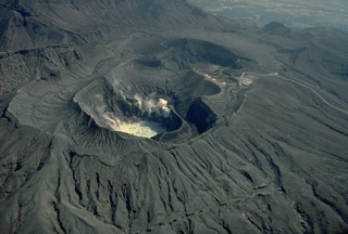 A group of overlapping craters marks the summit of Naka-dake volcano one of Japan's most active volcanoes. Seen here from the north, steam rises from a hot lake in the near crater and from fumaroles along its wall. Frequent explosive eruptions deposit ash and blocks on the flanks of the cone, leaving it unvegetated. A parking lot can be seen on the west rim of the crater, which is one of Kyushu's most popular tourist destinations.
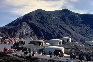 Tourists pack a parking lot at the summit crater of Naka-dake, the historically active crater of Aso volcano. The crater rim is readily accessible by toll road or aerial cable car and is a popular tourist destination. The circular concrete structures are emergency shelters to protect tourists in the event of a sudden volcanic eruption. Frequent, but intermittent, explosive eruptions eject ash and blocks onto the flanks of the cone and often prompt closure of the summit to visitors.
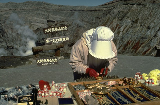 A souvenir vendor sells her wares on the crater rim of Naka-dake, the active cone of Aso caldera. The caldera is readily accessible by toll road and cable car and is one of Kyushu's most popular tourist destinations. Frequent eruptions prompt closure of the crater to tourists.
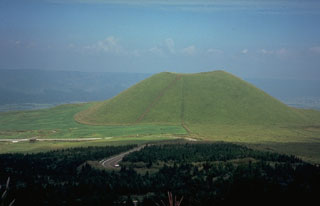 Kometsuka scoria cone, on the NW side of the central cone complex of Aso volcano on the island of Kyushu, was constructed about 1,800 years ago. The cone formed during explosive eruptions that were accompanied by lava flows. The Aso caldera walls are visible in the distance.
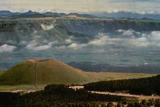 Kometsuka scoria cone (lower left) formed about 1,800 years ago in the Aso caldera complex. Clouds are above the broad caldera floor surrounding the cone complex and the NW wall of the 24-km-wide caldera is visible behind the cone. The caldera formed during four major Pleistocene explosive eruptions between 300,000 and 80,000 years ago.
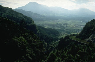 The 24-km-wide Aso caldera formed during four major Pleistocene explosive eruptions. These produced voluminous pyroclastic flows that swept over much of Kyushu. A group of 17 cones was constructed in the central part of the caldera, seen here from the ENE caldera rim. The Nakadake cone is one of Japan's most active volcanoes with recorded eruptions dating back to 553 CE.
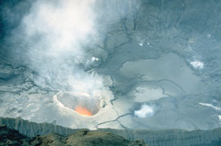 A plume rises from an incandescent vent on the floor of the crater of Nakadake on 25 April 1985. Moderate eruptions that ejected mud and ash had begun in April 1984 and continued intermittently until June 1985. Frequent ash eruptions occurred from 1 March to the night of 5-6 May 1985.
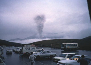 An ash plume rising above the crater of Aso on 11 October 1989 is observed by tourists from a nearby parking lot. Small ash plumes 30-50 m high occurred on 5 and 27 April 1989; additional plumes were frequent through May and June. Intermittent vigorous eruptions began on 16 July. Ash plumes reached 3,000 m on 7 and 27 September and heavy ashfall in October damaged crops. Intermittent eruptive activity continued until 9 February 1991.
The following 45 samples associated with this volcano can be found in the Smithsonian's NMNH Department of Mineral Sciences collections, and may be availble for research (contact the Rock and Ore Collections Manager). Catalog number links will open a window with more information.
| Catalog Number | Sample Description | Lava Source | Collection Date |
|---|---|---|---|
| NMNH 101508 | Unidentified | -- | -- |
| NMNH 101509 | Unidentified | -- | -- |
| NMNH 101510 | Unidentified | -- | -- |
| NMNH 101511 | Unidentified | -- | -- |
| NMNH 101512 | Unidentified | -- | -- |
| NMNH 101514 | Welded Tuff | -- | -- |
| NMNH 101515 | Lava | -- | -- |
| NMNH 101516 | Lava | -- | -- |
| NMNH 108940 | Andesite | -- | -- |
| NMNH 112939 | Granodiorite | TAKA-DAKE | -- |
| NMNH 112939 | Granodiorite | TAKA-DAKE | -- |
| NMNH 112940 | Olivine Trachybasalt | TAKA-DAKE | -- |
| NMNH 112940 | Olivine Trachybasalt | TAKA-DAKE | -- |
| NMNH 112944 | Augite Andesite | KIZIMA-DAKE CONE | -- |
| NMNH 112944 | Augite Andesite | KIZIMA-DAKE CONE | -- |
| NMNH 112945 | Dacite | SENRIGABAMA CONE | -- |
| NMNH 112945 | Dacite | SENRIGAHAMA CONE | -- |
| NMNH 112946 | Andesite | -- | -- |
| NMNH 112946 | Andesite | -- | -- |
| NMNH 112946 | Andesite | -- | -- |
| NMNH 112947 | Andesite | -- | -- |
| NMNH 112947 | Andesite | -- | -- |
| NMNH 112948 | Dacite | EBOSI-DAKE CONE | -- |
| NMNH 112948 | Dacite | EBOSI-DAKE CONE | -- |
| NMNH 112949 | Andesite | -- | -- |
| NMNH 112949 | Andesite | -- | -- |
| NMNH 112950 | Andesite | -- | -- |
| NMNH 112950 | Andesite | -- | -- |
| NMNH 112951 | Welded Tuff | -- | -- |
| NMNH 112951 | Welded Tuff | -- | -- |
| NMNH 112952 | Welded Tuff | -- | -- |
| NMNH 112952 | Welded Tuff | -- | -- |
| NMNH 113053 | Dunite | TAKA-DAKE | -- |
| NMNH 116397-12B | Welded Tuff | -- | -- |
| NMNH 116397-12C | Welded Tuff | -- | -- |
| NMNH 116397-12D | Welded Tuff | -- | -- |
| NMNH 116397-12E | Welded Tuff | -- | -- |
| NMNH 116397-12F | Welded Tuff | -- | -- |
| NMNH 116397-12G | Welded Tuff | -- | -- |
| NMNH 116397-12H | Welded Tuff | -- | -- |
| NMNH 116397-12I | Welded Tuff | -- | -- |
| NMNH 116397-13 | Welded Tuff | -- | -- |
| NMNH 116397-8 | Welded Tuff | -- | -- |
| NMNH 117451-5 | Obsidian | Sakanshi rhyolite | -- |
| NMNH 88662 | Lava | -- | -- |
| Copernicus Browser | The Copernicus Browser replaced the Sentinel Hub Playground browser in 2023, to provide access to Earth observation archives from the Copernicus Data Space Ecosystem, the main distribution platform for data from the EU Copernicus missions. |
| MIROVA | Middle InfraRed Observation of Volcanic Activity (MIROVA) is a near real time volcanic hot-spot detection system based on the analysis of MODIS (Moderate Resolution Imaging Spectroradiometer) data. In particular, MIROVA uses the Middle InfraRed Radiation (MIR), measured over target volcanoes, in order to detect, locate and measure the heat radiation sourced from volcanic activity. |
| MODVOLC Thermal Alerts | Using infrared satellite Moderate Resolution Imaging Spectroradiometer (MODIS) data, scientists at the Hawai'i Institute of Geophysics and Planetology, University of Hawai'i, developed an automated system called MODVOLC to map thermal hot-spots in near real time. For each MODIS image, the algorithm automatically scans each 1 km pixel within it to check for high-temperature hot-spots. When one is found the date, time, location, and intensity are recorded. MODIS looks at every square km of the Earth every 48 hours, once during the day and once during the night, and the presence of two MODIS sensors in space allows at least four hot-spot observations every two days. Each day updated global maps are compiled to display the locations of all hot spots detected in the previous 24 hours. There is a drop-down list with volcano names which allow users to 'zoom-in' and examine the distribution of hot-spots at a variety of spatial scales. |
|
WOVOdat
Single Volcano View Temporal Evolution of Unrest Side by Side Volcanoes |
WOVOdat is a database of volcanic unrest; instrumentally and visually recorded changes in seismicity, ground deformation, gas emission, and other parameters from their normal baselines. It is sponsored by the World Organization of Volcano Observatories (WOVO) and presently hosted at the Earth Observatory of Singapore.
GVMID Data on Volcano Monitoring Infrastructure The Global Volcano Monitoring Infrastructure Database GVMID, is aimed at documenting and improving capabilities of volcano monitoring from the ground and space. GVMID should provide a snapshot and baseline view of the techniques and instrumentation that are in place at various volcanoes, which can be use by volcano observatories as reference to setup new monitoring system or improving networks at a specific volcano. These data will allow identification of what monitoring gaps exist, which can be then targeted by remote sensing infrastructure and future instrument deployments. |
| Volcanic Hazard Maps | The IAVCEI Commission on Volcanic Hazards and Risk has a Volcanic Hazard Maps database designed to serve as a resource for hazard mappers (or other interested parties) to explore how common issues in hazard map development have been addressed at different volcanoes, in different countries, for different hazards, and for different intended audiences. In addition to the comprehensive, searchable Volcanic Hazard Maps Database, this website contains information about diversity of volcanic hazard maps, illustrated using examples from the database. This site is for educational purposes related to volcanic hazard maps. Hazard maps found on this website should not be used for emergency purposes. For the most recent, official hazard map for a particular volcano, please seek out the proper institutional authorities on the matter. |
| IRIS seismic stations/networks | Incorporated Research Institutions for Seismology (IRIS) Data Services map showing the location of seismic stations from all available networks (permanent or temporary) within a radius of 0.18° (about 20 km at mid-latitudes) from the given location of Asosan. Users can customize a variety of filters and options in the left panel. Note that if there are no stations are known the map will default to show the entire world with a "No data matched request" error notice. |
| UNAVCO GPS/GNSS stations | Geodetic Data Services map from UNAVCO showing the location of GPS/GNSS stations from all available networks (permanent or temporary) within a radius of 20 km from the given location of Asosan. Users can customize the data search based on station or network names, location, and time window. Requires Adobe Flash Player. |
| DECADE Data | The DECADE portal, still in the developmental stage, serves as an example of the proposed interoperability between The Smithsonian Institution's Global Volcanism Program, the Mapping Gas Emissions (MaGa) Database, and the EarthChem Geochemical Portal. The Deep Earth Carbon Degassing (DECADE) initiative seeks to use new and established technologies to determine accurate global fluxes of volcanic CO2 to the atmosphere, but installing CO2 monitoring networks on 20 of the world's 150 most actively degassing volcanoes. The group uses related laboratory-based studies (direct gas sampling and analysis, melt inclusions) to provide new data for direct degassing of deep earth carbon to the atmosphere. |
| Large Eruptions of Asosan | Information about large Quaternary eruptions (VEI >= 4) is cataloged in the Large Magnitude Explosive Volcanic Eruptions (LaMEVE) database of the Volcano Global Risk Identification and Analysis Project (VOGRIPA). |
| EarthChem | EarthChem develops and maintains databases, software, and services that support the preservation, discovery, access and analysis of geochemical data, and facilitate their integration with the broad array of other available earth science parameters. EarthChem is operated by a joint team of disciplinary scientists, data scientists, data managers and information technology developers who are part of the NSF-funded data facility Integrated Earth Data Applications (IEDA). IEDA is a collaborative effort of EarthChem and the Marine Geoscience Data System (MGDS). |

