Report on Fuego (Guatemala) — September 2020

Bulletin of the Global Volcanism Network, vol. 45, no. 9 (September 2020)
Managing Editor: Edward Venzke.
Edited by Kadie L. Bennis.
Fuego (Guatemala) Ongoing explosions, ash plumes, lava flows, and lahars during April-July 2020
Please cite this report as:
Global Volcanism Program, 2020. Report on Fuego (Guatemala) (Bennis, K.L., and Venzke, E., eds.). Bulletin of the Global Volcanism Network, 45:9. Smithsonian Institution. https://doi.org/10.5479/si.GVP.BGVN202009-342090
Fuego
Guatemala
14.4748°N, 90.8806°W; summit elev. 3799 m
All times are local (unless otherwise noted)
Fuego, located in Guatemala, is a stratovolcano that has been erupting since 2002 with historical eruptions dating back to 1531. Volcanism is characterized by major ashfalls, pyroclastic flows, lava flows, and lahars. The previous report (BGVN 45:04) described recent activity that included multiple ash explosions, block avalanches, and intermittent lava flows. This report updates activity from April through July 2020 that consisted of daily explosions, ash plumes, block avalanches ashfall, intermittent lava flows, and lahars. The primary source of information comes from the Instituto Nacional de Sismologia, Vulcanología, Meteorología e Hidrologia (INSIVUMEH), the Washington Volcanic Ash Advisory Center (VAAC), and various satellite data.
Summary of activity during April-July 2020. Daily activity throughout April-July 2020 was characterized by multiple hourly explosions, ash plumes that rose to a maximum of 4.9 km altitude, incandescent pulses that reached 600 m above the crater, block avalanches into multiple drainages, and ashfall affecting nearby communities (table 21). The highest rate of explosions occurred on 2 and 3 April and 2 May with up to 16 explosions per hour. White degassing occurred frequently during the reporting period, rising to a maximum altitude of 4.5 km and drifting in multiple directions. Intermittent lava flows were observed each month in the Seca (Santa Teresa) and Ceniza drainages (figure 132); the number of flows decreased in June through July, which is represented in the MIROVA analysis of MODIS satellite data, where the strength and frequency of thermal activity slightly decreased (figure 133). Occasional lahars were detected descending several drainages on the W and SE flanks, sometimes carrying tree branches and large blocks up to 1 m in diameter.
Table 21. Activity summary by month for Fuego with information compiled from INSIVUMEH daily reports.
| Month | Number of explosions per hour | Ash plume heights (km) | Ash plume distance (km) and direction | Drainages affected by block avalanches | Villages reporting ashfall |
| Apr 2020 | 5-16 | 4.3-4.9 km | 8-20 km E, NE, SE, W, NW, SW, S, N | Taniluyá, Ceniza, Las Lajas, Trinidad, Seca, Honda, and Santa Teresa | Morelia, Panimaché I and II, Sangre de Cristo, Santa Sofía, Finca Palo Verde, San Pedro Yepocapa, Las Cruces Quisache, La Rochela, Ceylan, and Osuna |
| May 2020 | 4-16 | 4.3-4.9 km | 10-17 km S, SW, W, N, NE, E, SE | Trinidad, Taniluyá, Ceniza, Las Lajas, Santa Teresa, Seca, and Honda | Panimaché I, La Rochela, Ceilán, Morelia, San Andrés Osuna, Finca Palo Verde, Santa Sofía, Seilán, San Pedro Yepocapa, Alotenango, Ciudad Vieja, San Miguel Dueñas, and Antigua Guatemala |
| Jun 2020 | 3-15 | 4.2-4.9 km | 10-25.9 km E, SE, S, N, NE, W, SW, NW | Seca, Taniluyá, Ceniza, Trinidad, Las Lajas, Santa Teresa and Honda | San Pedro Yepocapa, Sangre de Cristo, Panimaché I and II, Morelia, Finca Palo Verde, El Porvenir, Yucales, Santa Emilia, Santa Sofía |
| Jul 2020 | 1-15 | 4-4.9 km | 10-24 km W, NW, SW, S, NE | Trinidad, Taniluyá, Ceniza, Honda, Las Lajas, Seca, and Santa Teresa | Panimaché I and II, Morelia, Santa Sofía, Finca Palo Verde, Sangre de Cristo, San Pedro Yepocapa, and El Porvenir |
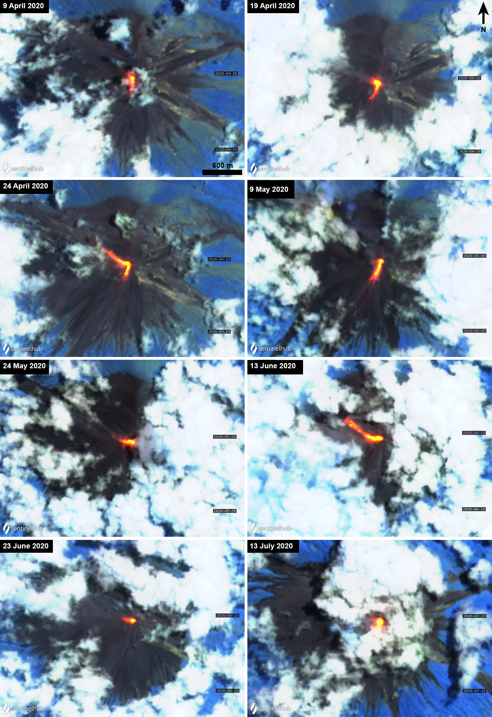 |
Figure 132. Sentinel-2 thermal satellite images of Fuego between 9 April 2020 and 13 July 2020 showing lava flows (bright yellow-orange) traveling generally S and W from the summit crater. Some lava flows were accompanied by gas emissions (9 April, 9 May, and 24 May 2020). Sentinel-2 satellite images with “Atmospheric penetration” (bands 12, 11, 8A) rendering; courtesy of Sentinel Hub Playground. |
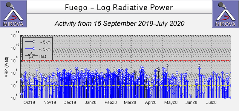 |
Figure 133. Thermal activity at Fuego was persistent and strong from 16 September through late May 2020, according to the MIROVA graph (Log Radiative Power). From early to mid-June activity seemed to stop briefly before resuming again at a lower rate. Courtesy of MIROVA. |
Activity during April-May 2020. Activity in April 2020 consisted of 5-16 explosions per hour, generating ash plumes that rose 4.3-4.9 km altitude and drifted 8-20 km in multiple directions. Ashfall was reported in Morelia (9 km SW), Panimaché I and II (8 km SW), Sangre de Cristo (8 km WSW), Santa Sofía (12 km SW), Finca Palo Verde, San Pedro Yepocapa (8 km NW), Las Cruces Quisache (8 km NW), La Rochela, Ceylan, Osuna (12 km SW). The Washington VAAC issued multiple aviation advisories for a total of six days in April. Intermittent white gas-and-steam emissions reached 4.1-4.5 km altitude drifting in multiple directions. Incandescent ejecta was frequently observed rising 75-400 m above the crater; material ejected up to 600 m above the crater on 11 April. These constant explosions produced block avalanches that traveled down the Taniluyá (SW), Ceniza (SSW), Las Lajas (SE), Trinidad (S), Seca (W), Honda, and Santa Teresa (W) drainages. Effusive activity was reported on 6-13 and 15 April from the summit vent, traveling 150-800 m down the Ceniza drainage, accompanied by block avalanches in the front of the flow up to 1 km. Crater incandescence was also observed.
On 19-20 April a new lava flow descended the Ceniza drainage measuring 200-400 long, generating incandescent block avalanches at the front of the flow that moved up to 1 km. On 22 April lahars descended the Honda, Las Lajas, El Juté (SE), Trinidad, Ceniza, Taniluyá, Mineral, and Seca drainages and tributaries in Guacalate, Achiguate, and Pantaleón. During the evening of 23 April the rate of effusive activity increased; observatory staff observed a second lava flow in the Seca drainage was 170 m long and incandescent blocks from the flow traveled up to 600 m. Two lava flows in the Ceniza (130-400 m) and Seca (150-800 m) drainages continued from 23-28 April and had stopped by 30 April. On 30 April weak and moderate explosions produced ash plumes that rose 4.5-4.7 km altitude drifting S and SE, resulting in fine ashfall in Panimaché I, Morelia, Santa Sofía (figure 134).
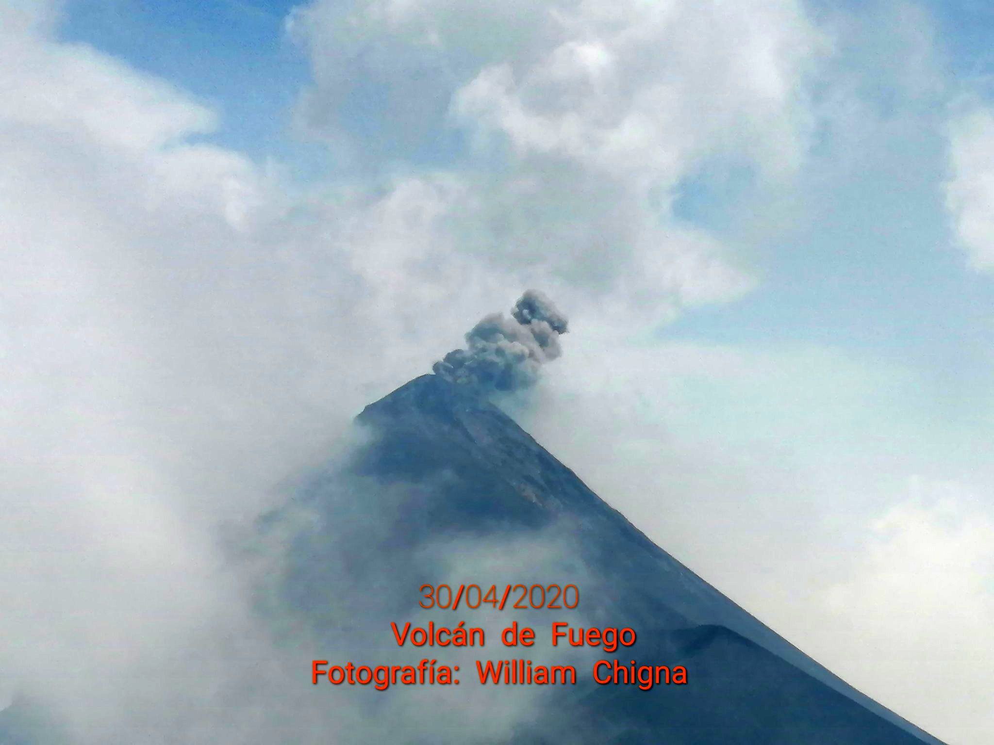 |
Figure 134. Photo of a small ash plume rising from Fuego on 30 April 2020. Photo has been slightly color corrected. Courtesy of William Chigna, CONRED. |
During May 2020, the rate of explosion remained similar, with 4-16 explosions per hour, which generated gray ash plumes that rose 4.3-4.9 km altitude and drifted 10-17 km generally W and E. Ashfall was observed in Panimaché I, La Rochela, Ceilán, Morelia, San Andrés Osuna, Finca Palo Verde, Santa Sofía, Seilán, San Pedro Yepocapa, Alotenango (8 km ENE), Ciudad Vieja (13.5 km NE), San Miguel Dueñas (10 km NE), and Antigua Guatemala (18 km NE). The Washington VAAC issued volcanic ash advisory notices on six days in May. White gas-and-steam emissions continued, rising 4-4.5 km altitude drifting in multiple directions. Incandescent ejecta rose 100-400 m above the crater, accompanied by some crater incandescence and block avalanches in the Trinidad, Taniluyá, Ceniza, Las Lajas, Santa Teresa, Seca, and Honda drainages that moved up to 1 km and sometimes reached vegetated areas.
During 8-11 May a new 400 m long lava flow was detected in the Ceniza drainage, accompanied by constant crater incandescence and block avalanches traveling up to 1 km, according to INSIVUMEH. On 8 and 17 May moderate to strong lahars descended the Santa Teresa and Mineral drainages on the W flank and on 21 May they descended the Las Lajas drainage on the E flank and the Ceniza drainage on the SW flank. During 20-24 May a 100-400 m long lava flow was reported in the Ceniza drainage alongside degassing and avalanches moving up to 1 km and during 25-26 May a 150 m long lava flow was reported in the Seca drainage.
Activity during June-July 2020. The rate of explosions in June 2020 decreased slightly to 3-15 per hour, generating gray ash plumes that rose 4.2-4.9 km altitude and drifted 10-26 km in multiple directions (figure 135). As a result, intermittent ashfall was reported in San Pedro Yepocapa, Sangre de Cristo, Panimaché I and II, Morelia, Finca Palo Verde, El Porvenir (8 km ENE), Yucales (12 km SW), Santa Emilia, Santa Sofia, according to INSIVUMEH. VAAC advisories were published on eight days in June. Degassing persisted in the summit crater that rose 4.1-4.5 km altitude extending in different directions. Crater incandescence was observed occasionally, as well as incandescent pulses that rose 100-300 m above the crater. Block avalanches were observed descending the Seca, Taniluyá, Ceniza, Trinidad, Las Lajas, Santa Teresa, and Honda drainages, which could sometimes carry blocks up to 1 km in diameter.
On 2 June at 1050 a weak to moderate lahar was observed in the Las Lajas drainage on the SE flank. On 5 June, more lahars were detected in the Seca and Mineral drainages on the W flanks. A new lava flow was detected on 12 June, traveling 250 m down the Seca drainage on the NW flank, and accompanied by constant summit crater incandescence and gas emissions. The flow continued into 14 June, lengthening up to 300 m long. On 24 June weak and moderate explosions produced ash plumes that rose 4.3-4.7 km altitude drifting W and SW (figure 135). On 29 June at 1300 a weak lahar was reported in the Seca, Santa Teresa, and Mineral drainages on the W flank.
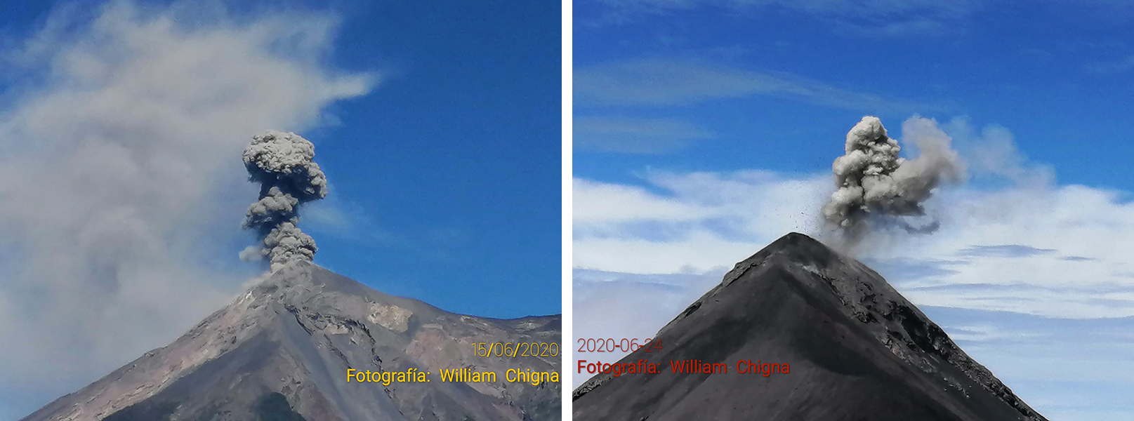 |
Figure 135. Examples of small ash plumes at Fuego on 15 (left) and 24 (right) June 2020. Courtesy of William Chigna, CONRED. |
Daily explosions and ash plumes continued through July 2020, with 1-15 explosions per hour and producing consistent ash plumes 4-4.9 km altitude drifting generally W for 10-24 km. These explosions resulted in block avalanches that descended the Trinidad, Taniluyá, Ceniza, Honda, Las Lajas, Seca, and Santa Teresa drainages. The number of white gas emissions decrease slightly compared to previous months and 4-4.4 km altitude. VAAC advisories were distributed on twenty different days in July. Incandescent ejecta was observed rising 100-350 m above the crater. Occasional ashfall was observed in Panimaché I and II, Morelia, Santa Sofía, Finca Palo Verde, Sangre de Cristo, San Pedro Yepocapa, and El Porvenir, according to INSIVUMEH.
On 4 July in the early morning, a lava flow began in the Seca drainage, which also produced some fine ash particles that drifted W. The lava flow continued into 5 July, measuring 150 m long. On the same day, weak to moderate lahars traveled only 20 m, carrying tree branches and blocks measuring 30 cm to 1 m. On 14, 24, and 29 July more lahars were generated in the Las Lajas drainages on the former date and both the Las Lajas and El Jute drainages on the two latter dates.
Geological Summary. Volcán Fuego, one of Central America's most active volcanoes, is also one of three large stratovolcanoes overlooking Guatemala's former capital, Antigua. The scarp of an older edifice, Meseta, lies between Fuego and Acatenango to the north. Construction of Meseta dates back to about 230,000 years and continued until the late Pleistocene or early Holocene. Collapse of Meseta may have produced the massive Escuintla debris-avalanche deposit, which extends about 50 km onto the Pacific coastal plain. Growth of the modern Fuego volcano followed, continuing the southward migration of volcanism that began at the mostly andesitic Acatenango. Eruptions at Fuego have become more mafic with time, and most historical activity has produced basaltic rocks. Frequent vigorous eruptions have been recorded since the onset of the Spanish era in 1524, and have produced major ashfalls, along with occasional pyroclastic flows and lava flows.
Information Contacts: Instituto Nacional de Sismologia, Vulcanologia, Meteorologia e Hydrologia (INSIVUMEH), Unit of Volcanology, Geologic Department of Investigation and Services, 7a Av. 14-57, Zona 13, Guatemala City, Guatemala (URL: http://www.insivumeh.gob.gt/); Washington Volcanic Ash Advisory Center (VAAC), Satellite Analysis Branch (SAB), NOAA/NESDIS OSPO, NOAA Science Center Room 401, 5200 Auth Rd, Camp Springs, MD 20746, USA (URL: www.ospo.noaa.gov/Products/atmosphere/vaac, archive at: http://www.ssd.noaa.gov/VAAC/archive.html); MIROVA (Middle InfraRed Observation of Volcanic Activity), a collaborative project between the Universities of Turin and Florence (Italy) supported by the Centre for Volcanic Risk of the Italian Civil Protection Department (URL: http://www.mirovaweb.it/); Sentinel Hub Playground (URL: https://www.sentinel-hub.com/explore/sentinel-playground); William Chigna, CONRED (URL: https://twitter.com/william_chigna).