Report on Manam (Papua New Guinea) — October 2020

Bulletin of the Global Volcanism Network, vol. 45, no. 10 (October 2020)
Managing Editor: Edward Venzke.
Edited by Kadie L. Bennis.
Manam (Papua New Guinea) Intermittent ash plumes, thermal anomalies, and SO2 emissions in April-September 2020
Please cite this report as:
Global Volcanism Program, 2020. Report on Manam (Papua New Guinea) (Bennis, K.L., and Venzke, E., eds.). Bulletin of the Global Volcanism Network, 45:10. Smithsonian Institution. https://doi.org/10.5479/si.GVP.BGVN202010-251020
Manam
Papua New Guinea
4.08°S, 145.037°E; summit elev. 1807 m
All times are local (unless otherwise noted)
Manam, located 13 km off the N coast of Papua New Guinea, is a basaltic-andesitic stratovolcano with historical eruptions dating back 400 years. Volcanism has been characterized by low-level ash plumes, occasional Strombolian activity, lava flows, pyroclastic avalanches, and large ash plumes from Main and South, the two active summit craters. The current eruption period has been ongoing since 2014, typically with minor explosive activity, thermal activity, and SO2 emissions (BGVN 45:05). This reporting period updates information from April through September 2020, consisting of intermittent ash plumes from late July to mid-September, persistent thermal anomalies, and SO2 emissions. Information comes from Papua New Guinea's Rabaul Volcano Observatory (RVO), part of the Department of Mineral Policy and Geohazards Management (DMPGM), the Darwin Volcanic Ash Advisory Center (VAAC), and various satellite data.
Explosive activity was relatively low during April through late July; SO2 emissions and low power, but persistent, thermal anomalies were detected by satellite instruments each month. The TROPOMI instrument on the Sentinel-5P satellite recorded SO2 emissions, many of which exceeded two Dobson Units, that drifted generally W (figure 76). Distinct SO2 emissions were detected for 10 days in April, 4 days in May, 10 days in June, 4 days in July, 11 days in August, and 8 days in September.
Thermal anomalies recorded by the MIROVA (Middle InfraRed Observation of Volcanic Activity) system were sparse from early January through June 2020, totaling 11 low-power anomalies within 5 km of the summit (figure 77). From late July through September a pulse in thermal activity produced slightly stronger and more frequent anomalies. Some of this activity could be observed in Sentinel-2 thermal satellite imagery (figure 78). Occasionally, these thermal anomalies were accompanied by gas-and-steam emissions or ash plumes, as shown on 28 July. On 17 August a particularly strong hotspot was detected in the S summit crater. According to the MODVOLC thermal alert data, a total of 10 thermal alerts were detected in the summit crater over four days: 29 July (5), 16 August (1), and 3 (1) and 8 (3) September.
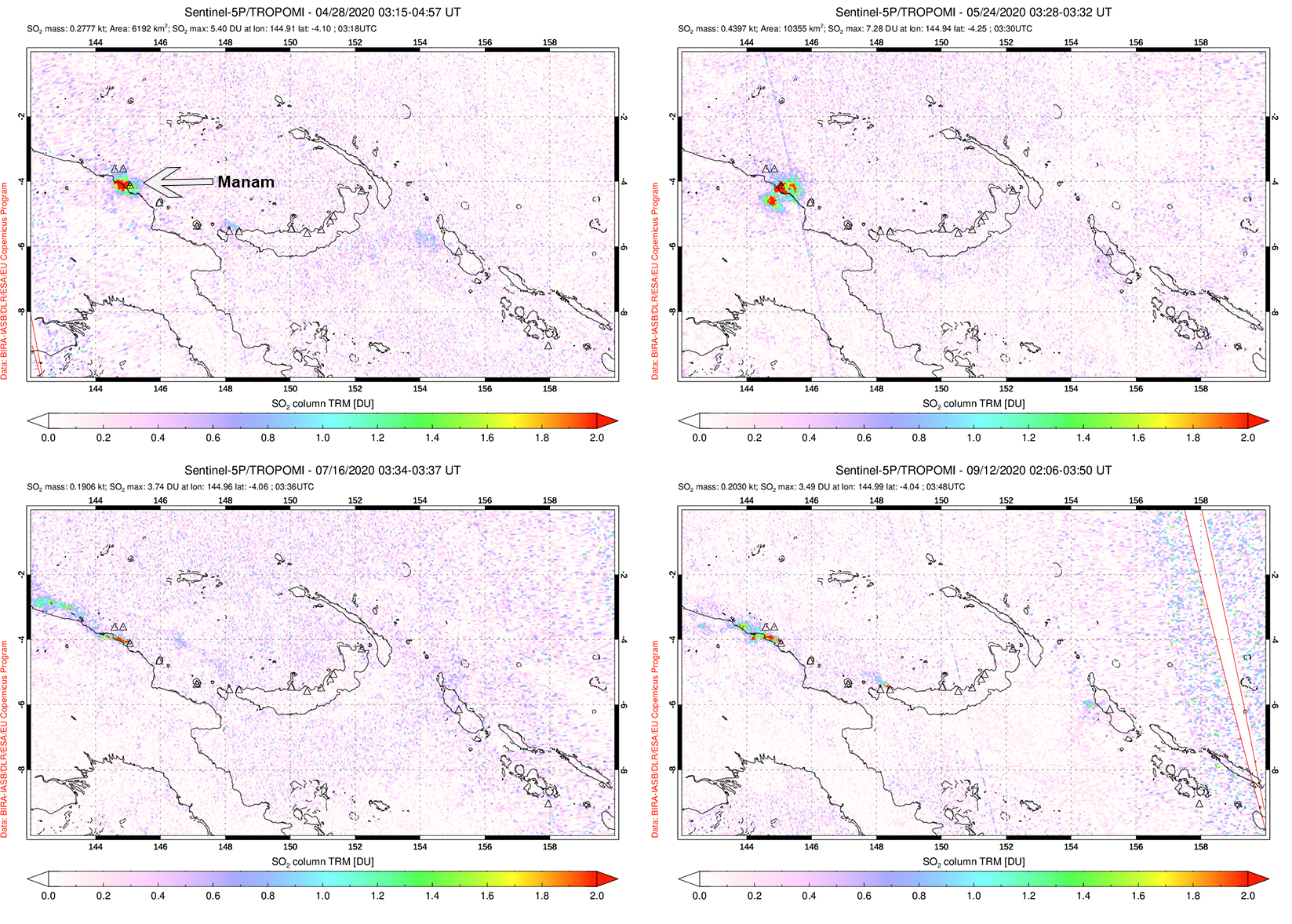 |
Figure 76. Distinct sulfur dioxide plumes rising from Manam and drifting generally W were detected using data from the TROPOMI instrument on the Sentinel-5P satellite on 28 April (top left), 24 May (top right), 16 July (bottom left), and 12 September (bottom right) 2020. Courtesy of the NASA Global Sulfur Dioxide Monitoring Page. |
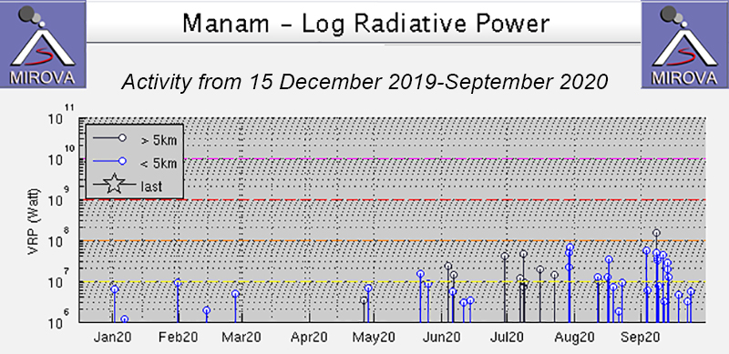 |
Figure 77. Intermittent thermal activity at Manam increased in power and frequency beginning around late July and continuing through September 2020, as shown on the MIROVA Log Radiative Power graph. Courtesy of MIROVA. |
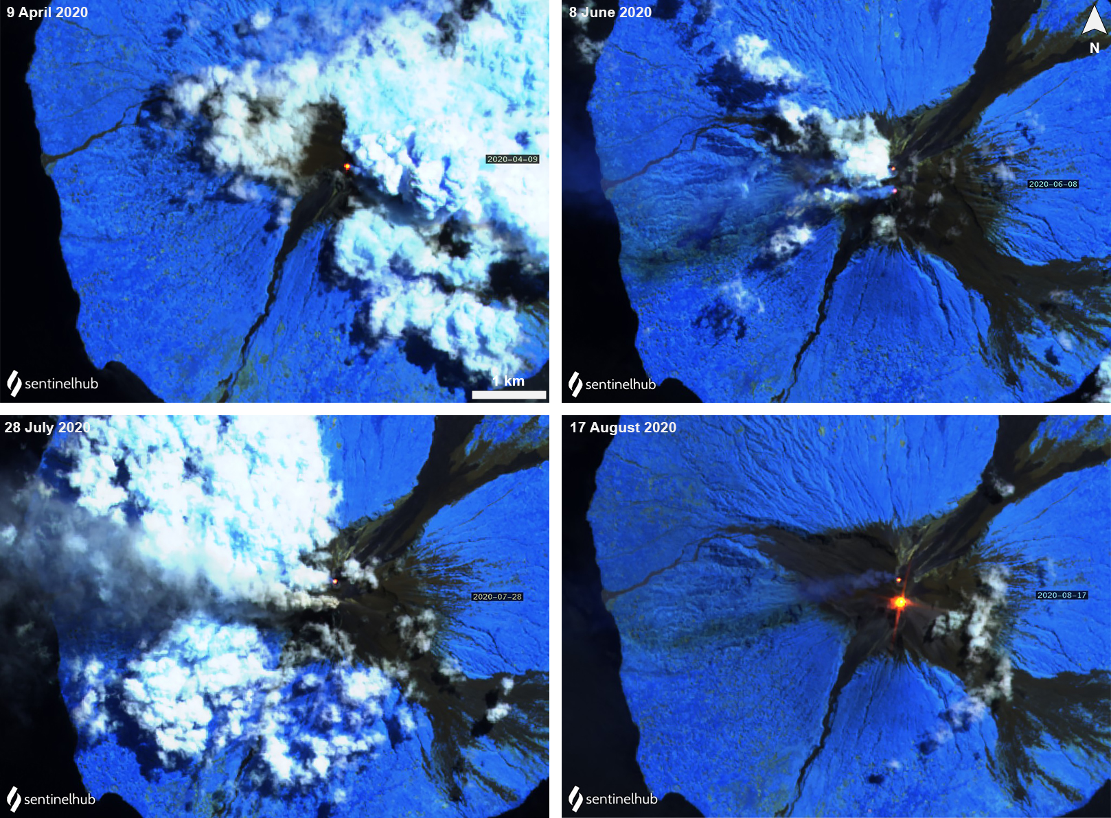 |
Figure 78. Sentinel-2 thermal satellite images showing a persistent thermal anomaly (yellow-orange) at Manam’s summit craters (Main and South) each month during April through August; sometimes they were seen in both summit craters, as shown on 8 June (top right), 28 July (bottom left), and 17 August (bottom right). A particularly strong anomaly was visible on 17 August (bottom right). Occasional gas-and-steam emissions accompanied the thermal activity. Sentinel-2 satellite images with “Atmospheric penetration” (bands 12, 11, 8A) rendering; courtesy of Sentinel Hub Playground. |
Activity during mid-July slightly increased compared to the previous months. On 16 July seismicity increased, fluctuating between low and moderate RSAM values through the rest of the month. In Sentinel-2 satellite imagery a gray ash plume was visible rising from the S summit crater on 28 July (figure 78). RSAM values gradually increased from a low average of 200 to an average of 1200 on 30 July, accompanied by thermal hotspots around the summit crater; a ground observer reported incandescent material was ejected from the summit. On 31 July into 1 August ash plumes rose to 4.3 km altitude, accompanied by an incandescent lava flow visible at the summit, according to a Darwin VAAC advisory.
Intermittent ash plumes continued to be reported by the Darwin VAAC on 1, 6-7, 16, 20, and 31 August. They rose from 2.1 to 4.6 km altitude, the latter of which occurred on 31 August and drifted W. Typically, these ash plumes extended SW, W, NW, and WSW. On 11 September another ash plume was observed rising 2.4 km altitude and drifting W.
Geological Summary. The 10-km-wide island of Manam, lying 13 km off the northern coast of mainland Papua New Guinea, is one of the country's most active volcanoes. Four large radial valleys extend from the unvegetated summit of the conical basaltic-andesitic stratovolcano to its lower flanks. These valleys channel lava flows and pyroclastic avalanches that have sometimes reached the coast. Five small satellitic centers are located near the island's shoreline on the northern, southern, and western sides. Two summit craters are present; both are active, although most observed eruptions have originated from the southern crater, concentrating eruptive products during much of the past century into the SE valley. Frequent eruptions, typically of mild-to-moderate scale, have been recorded since 1616. Occasional larger eruptions have produced pyroclastic flows and lava flows that reached flat-lying coastal areas and entered the sea, sometimes impacting populated areas.
Information Contacts: Rabaul Volcano Observatory (RVO), Geohazards Management Division, Department of Mineral Policy and Geohazards Management (DMPGM), PO Box 3386, Kokopo, East New Britain Province, Papua New Guinea; Darwin Volcanic Ash Advisory Centre (VAAC), Bureau of Meteorology, Northern Territory Regional Office, PO Box 40050, Casuarina, NT 0811, Australia (URL: http://www.bom.gov.au/info/vaac/); MIROVA (Middle InfraRed Observation of Volcanic Activity), a collaborative project between the Universities of Turin and Florence (Italy) supported by the Centre for Volcanic Risk of the Italian Civil Protection Department (URL: http://www.mirovaweb.it/); Hawai'i Institute of Geophysics and Planetology (HIGP) - MODVOLC Thermal Alerts System, School of Ocean and Earth Science and Technology (SOEST), Univ. of Hawai'i, 2525 Correa Road, Honolulu, HI 96822, USA (URL: http://modis.higp.hawaii.edu/); Global Sulfur Dioxide Monitoring Page, Atmospheric Chemistry and Dynamics Laboratory, NASA Goddard Space Flight Center (NASA/GSFC), 8800 Greenbelt Road, Goddard, Maryland, USA (URL: https://so2.gsfc.nasa.gov/); Sentinel Hub Playground (URL: https://www.sentinel-hub.com/explore/sentinel-playground).