Report on Semeru (Indonesia) — October 2020

Bulletin of the Global Volcanism Network, vol. 45, no. 10 (October 2020)
Managing Editor: Edward Venzke.
Edited by Kadie L. Bennis. Research and preparation by Paul Berger.
Semeru (Indonesia) Ash plumes, lava flows, avalanches, and pyroclastic flows during March-August 2020
Please cite this report as:
Global Volcanism Program, 2020. Report on Semeru (Indonesia) (Bennis, K.L., and Venzke, E., eds.). Bulletin of the Global Volcanism Network, 45:10. Smithsonian Institution. https://doi.org/10.5479/si.GVP.BGVN202010-263300
Semeru
Indonesia
8.108°S, 112.922°E; summit elev. 3657 m
All times are local (unless otherwise noted)
Semeru in eastern Java, Indonesia, has been erupting almost continuously since 1967 and is characterized by ash plumes, pyroclastic flows, lava flows and lava avalanches down drainages on the SE flanks. The Alert Level has remained at 2 (on a scale of 1-4) since May 2012, and the public reminded to stay outside of the general 1-km radius from the summit and 4 km on the SSE flank. This report updates volcanic activity from March to August 2020, using primary information from the Pusat Vulkanologi dan Mitigasi Bencana Geologi (PVMBG, also known as Indonesian Center for Volcanology and Geological Hazard Mitigation, CVGHM), the Darwin Volcanic Ash Advisory Centre (VAAC), and satellite data.
Activity at Semeru consisted of dominantly dense white-gray ash plumes rising 100-600 m above the crater, incandescent material that was ejected 10-50 m high and descended 300-2,000 from the summit crater, and lava flows measuring 500-1,000 m long. Two pyroclastic flows were also observed, extending 2.3 km from the summit crater in March and 2 km on 17 April.
During 1-2 March gray ash plumes rose 200-500 m above the crater, accompanied by incandescent material that was ejected 10-50 m above the Jonggring-Seloko Crater. Lava flows reaching 500-1,000 m long traveled down the Kembar, Bang, and Kobokan drainages on the S flank. During 4-10 March ash plumes up to 200 m high were interspersed with 100-m-high white gas-and-steam plumes. At the end of a 750-m-long lava flow on the S flank, a pyroclastic flow that lasted 9 minutes traveled as far as 2.3 km. During 25-31 March incandescent material found at the end of the lava flow descended 700-950 m from the summit crater (figure 42).
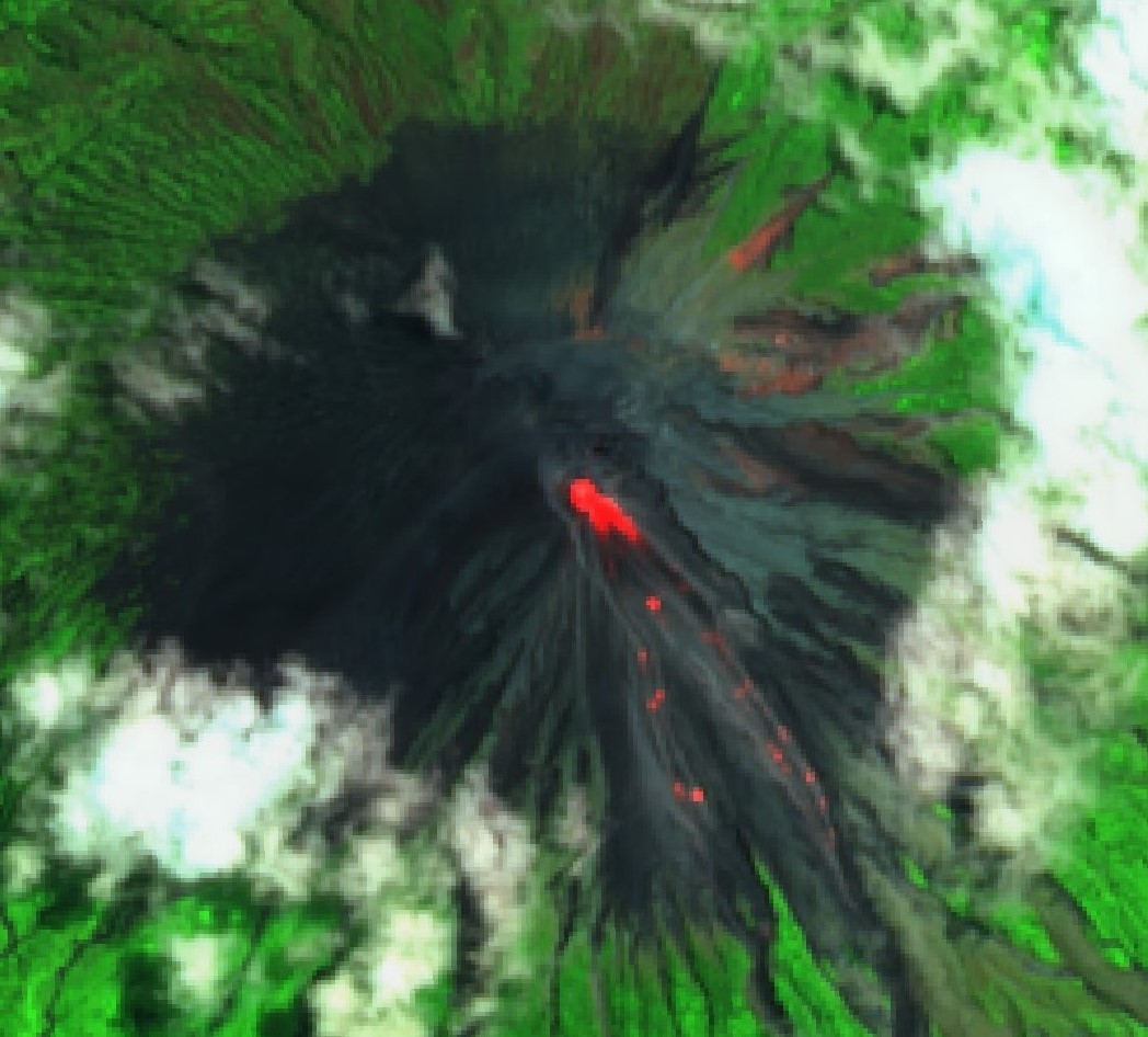 |
Figure 42. Sentinel-2 thermal satellite imagery showed lava avalanches descending the SSE flank on 26 March 2020. Images using short-wave infrared (SWIR, bands 12, 8A, 4) rendering; courtesy of Sentinel Hub Playground. |
Incandescent material continued to be observed in April, rising 10-50 m above the Jonggring-Seloko Crater. Some incandescent material descended from the ends of lava flows as far as 700-2,000 m from the summit crater. Dense white-gray ash plumes rose 100-600 m above the crater drifting N, SE, and SW. During 15-21 April incandescent lava flows traveled 500-1,000 m down the Kembar, Bang, and Kobokan drainages on the S flank. On 17 April at 0608 a pyroclastic flow was observed on the S flank in the Bang drainage measuring 2 km (figure 43). During 22-28 April lava blocks traveled 300 m from the end of lava flows in the Kembar drainage.
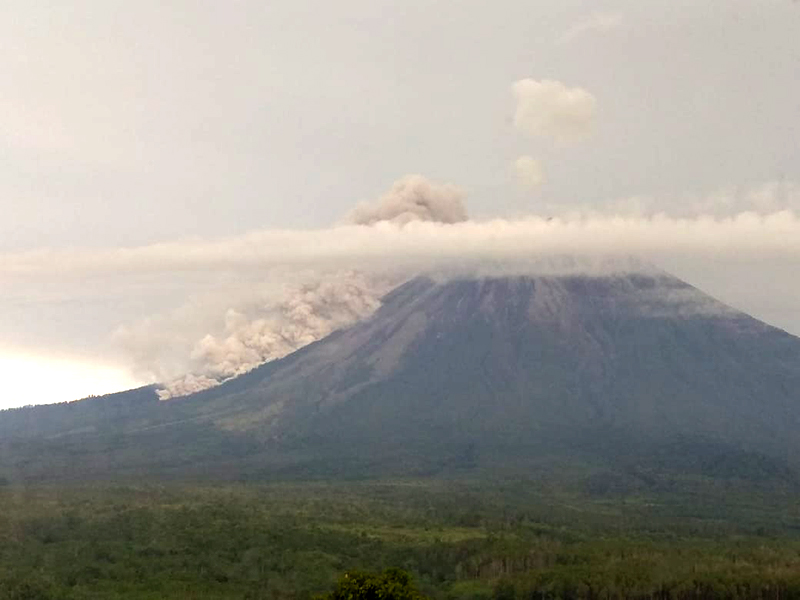 |
Figure 43. A pyroclastic flow at Semeru on 17 April 2020 moving down the S flank toward Besuk Bang. Photo has been color corrected. Courtesy of PVMBG. |
Similar activity continued in May, with incandescent material from lava flows in the Kembar and Kobokan drainages descending a maximum distance of 2 km during 29 April-12 May, and 200-1,200 m in the Kembar drainage during 13-27 May, accompanied by dense white-gray ash plumes rising 100-500 m above the crater drifting in different directions. White gas-and-steam plumes rose 300 m above the crater on 26-27 May. Dense white-to-gray ash plumes were visible most days during June, rising 100-500 m above the crater and drifting in various directions. During 3-9 June incandescent material from lava flows descended 200-1,600 m in the Kembar drainage.
Activity in July had decreased slightly and consisted of primarily dense white-gray ash plumes that ranged from 200-500 m above the crater and drifted W, SW, N, and S. Weather conditions often prevented visual observations. On 7 July an ash plume at 0633 rose 400 m drifting W. Similar ash activity was observed in August rising 200-500 m above the crater. On 14 and 16 August a Darwin VAAC advisory stated that white-gray ash plumes rose 300-400 m above the crater, drifting W and WSW; on 16 August a thermal anomaly was observed in satellite imagery. MAGMA Indonesia reported ash plumes were visible during 19-31 August and rose 200-400 m above the crater, drifting S and SW.
Hotspots were recorded by MODVOLC on 11, 6, and 7 days during March, April, and May, respectively, with as many as four pixels in March. Thermal activity decreased to a single hotspot in July and none in August. The MIROVA (Middle InfraRed Observation of Volcanic Activity) system recorded numerous thermal anomalies at the volcano during March-July; a lower number was recorded during August (figure 44). The NASA Global Sulfur Dioxide page showed high levels of sulfur dioxide above or near Semeru on 18, 24-25, and 29-31 March, and 9 April.
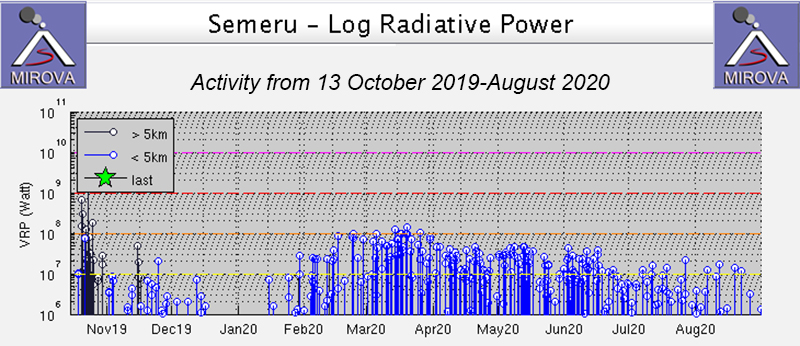 |
Figure 44. Thermal anomalies at Semeru detected during March-June 2020. Courtesy of MIROVA. |
Geological Summary. Semeru, the highest volcano on Java, and one of its most active, lies at the southern end of a volcanic massif extending north to the Tengger caldera. The steep-sided volcano, also referred to as Mahameru (Great Mountain), rises above coastal plains to the south. Gunung Semeru was constructed south of the overlapping Ajek-ajek and Jambangan calderas. A line of lake-filled maars was constructed along a N-S trend cutting through the summit, and cinder cones and lava domes occupy the eastern and NE flanks. Summit topography is complicated by the shifting of craters from NW to SE. Frequent 19th and 20th century eruptions were dominated by small-to-moderate explosions from the summit crater, with occasional lava flows and larger explosive eruptions accompanied by pyroclastic flows that have reached the lower flanks of the volcano.
Information Contacts: Pusat Vulkanologi dan Mitigasi Bencana Geologi (PVMBG, also known as Indonesian Center for Volcanology and Geological Hazard Mitigation, CVGHM), Jalan Diponegoro 57, Bandung 40122, Indonesia (URL: http://www.vsi.esdm.go.id/); MAGMA Indonesia (Multiplatform Application for Geohazard Mitigation and Assessment in Indonesia), PVMBG, Kementerian Energi dan Sumber Daya Mineral (URL: https://magma.vsi.esdm.go.id); Darwin Volcanic Ash Advisory Centre (VAAC), Bureau of Meteorology, Northern Territory Regional Office, PO Box 40050, Casuarina, NT 0811, Australia (URL: http://www.bom.gov.au/info/vaac/); MIROVA (Middle InfraRed Observation of Volcanic Activity), a collaborative project between the Universities of Turin and Florence (Italy) supported by the Centre for Volcanic Risk of the Italian Civil Protection Department (URL: http://www.mirovaweb.it/); Hawai'i Institute of Geophysics and Planetology (HIGP) - MODVOLC Thermal Alerts System, School of Ocean and Earth Science and Technology (SOEST), Univ. of Hawai'i, 2525 Correa Road, Honolulu, HI 96822, USA (URL: http://modis.higp.hawaii.edu/); Global Sulfur Dioxide Monitoring Page, Atmospheric Chemistry and Dynamics Laboratory, NASA Goddard Space Flight Center (NASA/GSFC), 8800 Greenbelt Road, Goddard, Maryland, USA (URL: https://so2.gsfc.nasa.gov/); Sentinel Hub Playground (URL: https://www.sentinel-hub.com/explore/sentinel-playground).