Report on Sinabung (Indonesia) — November 2020
Bulletin of the Global Volcanism Network, vol. 45, no. 11 (November 2020)
Managing Editor: Edward Venzke.
Edited by A. Elizabeth Crafford.
Sinabung (Indonesia) Explosions begin again on 8 August 2020; dome growth confirmed in late September
Please cite this report as:
Global Volcanism Program, 2020. Report on Sinabung (Indonesia) (Crafford, A.E., and Venzke, E., eds.). Bulletin of the Global Volcanism Network, 45:11. Smithsonian Institution. https://doi.org/10.5479/si.GVP.BGVN202011-261080
Sinabung
Indonesia
3.17°N, 98.392°E; summit elev. 2460 m
All times are local (unless otherwise noted)
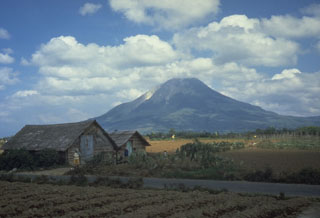
Indonesia’s Sinabung volcano in north Sumatra has been highly active since its first confirmed Holocene eruption during August and September 2010. It remained quiet after the initial eruption until September 2013, when a new eruptive phase began that continued through June 2018. A summit dome emerged in late 2013 and produced a large lava “tongue” during 2014. Multiple explosions produced ash plumes, block avalanches, and deadly pyroclastic flows during the eruptive period. A major explosion in February 2018 destroyed most of the summit dome. After a pause in eruptive activity from September 2018 through April 2019, explosions resumed during May and June 2019. The volcano was quiet again until an explosion on 8 August 2020 began another eruption that included a new dome. This report covers activity from July 2019 through October 2020 with information provided by Pusat Vulkanologi dan Mitigasi Bencana Geologi (PVMBG), referred to by some agencies as CVGHM or the Indonesian Center of Volcanology and Geological Hazard Mitigation, the Darwin Volcanic Ash Advisory Centre (VAAC), and the Badan Nacional Penanggulangan Bencana (National Disaster Management Authority, BNPB). Additional information comes from satellite instruments and local news reports.
Only steam plumes and infrequent lahars were reported at Sinabung during July 2019-July 2020. A new eruption began on 8 August 2020 with a phreatic explosion and dense ash plumes. Repeated explosions were reported throughout August; ashfall was reported in many nearby communities several times. Explosions decreased significantly during September, but SO2 emissions persisted. Block avalanches from a new growing dome were first reported in early October; pyroclastic flows accompanied repeated ash emissions during the last week of the month. Thermal data suggested that the summit dome continued growing slowly during October.
Activity during July 2019-October 2020. After a large explosion on 9 June 2019, activity declined significantly, and no further emissions or incandescence was reported after 25 June (BGVN 44:08). For the remainder of 2019 steam plumes rose 50-400 m above the summit on most days, occasionally rising to 500-700 m above the crater. Lahars were recorded by seismic instruments in July, August, September, and December. During January-July 2020 steam plumes were reported usually 50-300 m above the summit, sometimes rising to 500 m. On 21 March 2020 steam plumes rose to 700 m, and a lahar was recorded by seismic instruments. Lahars were reported on 26 and 28 April, 3 and 5 June, and 11 July.
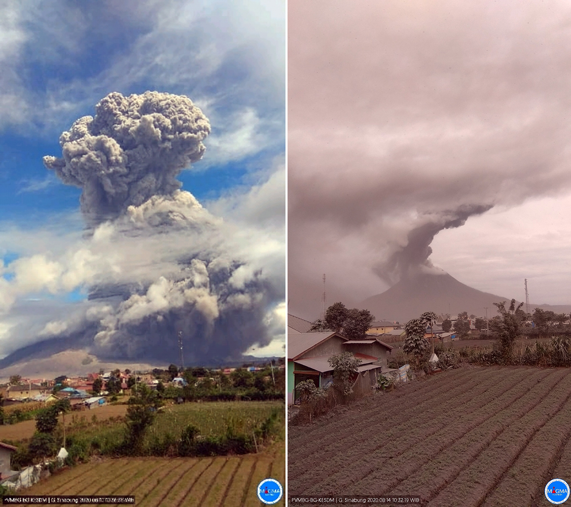
A swarm of deep volcanic earthquakes was reported by PVMBG on 7 August 2020. This was followed by a phreatic explosion with a dense gray to black ash plume on 8 August that rose 2,000 m above the summit and drifted E; a second explosion that day produced a plume that rose 1,000 m above the summit. According to the Jakarta Post, ash reached the community of Berastagi (15 km E) along with the districts of Naman Teran (5-10 km NE), Merdeka (15 km NE), and Dolat Rayat (20 km E). Continuous tremor events were first recorded on 8 August and continued daily until 26 August. Two explosions were recorded on 10 August; the largest produced a dense gray ash plume that rose 5,000 m above the summit and drifted NE and SE (figure 77). The Darwin VAAC reported the eruption clearly visible in satellite imagery at 9.7 km altitude and drifting W. Later they reported a second plume drifting ESE at 4.3 km altitude. After this large explosion the local National Disaster Management Authority (BNPB) reported significant ashfall in three districts: Naman Teran, Berastagi and Merdeka. Emissions on 11 and 12 August were white and gray and rose 100-200 m. Multiple explosions on 13 August produced white and gray ash plumes that rose 1,000-2,000 m above the summit. Explosions on 14 August produced gray and brown ash plumes that rose 1,000-4,200 m above the summit and drifted S and SW (figure 77). The Darwin VAAC reported that the ash plume was partly visible in satellite imagery at 7.6 km altitude moving W; additional plumes were moving SE at 3.7 km altitude and NE at 5.5 km altitude.
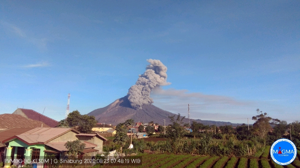
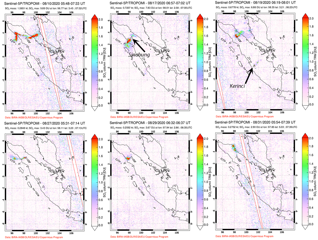
White, gray, and brown emissions rose 800-1,000 m above the summit on 15 and 17 August. The next day white and gray emissions rose 2,000 m above the summit. The Darwin VAAC reported an ash plume visible at 5.2 km altitude drifting SW. A large explosion on 19 August produced a dense gray ash plume that rose 4,000 above the summit and drifted S and SW. Gray and white emissions rose 500 m on 20 August. Two explosions were recorded seismically on 21 August, but rainy and cloudy weather prevented observations. White steam plumes rose 300 m on 22 August, and a lahar was recorded seismically. On 23 August, an explosion produced a gray ash plume that rose 1,500 m above the summit and pyroclastic flows that traveled 1,000 m down the E and SE flanks (figure 78). Continuous tremors were accompanied by ash emissions. White, gray, and brown emissions rose 600 m on 24 August. An explosion on 25 August produced an ash plume that rose 800 m above the peak and drifted W and NW (figure 79). During 26-30 August steam emissions rose 100-400 m above the summit and no explosions were recorded. Dense gray ash emissions rose 1,000 m and drifted E and NE after an explosion on 31 August. Significant SO2 emissions were associated with many of the explosions during August (figure 80).
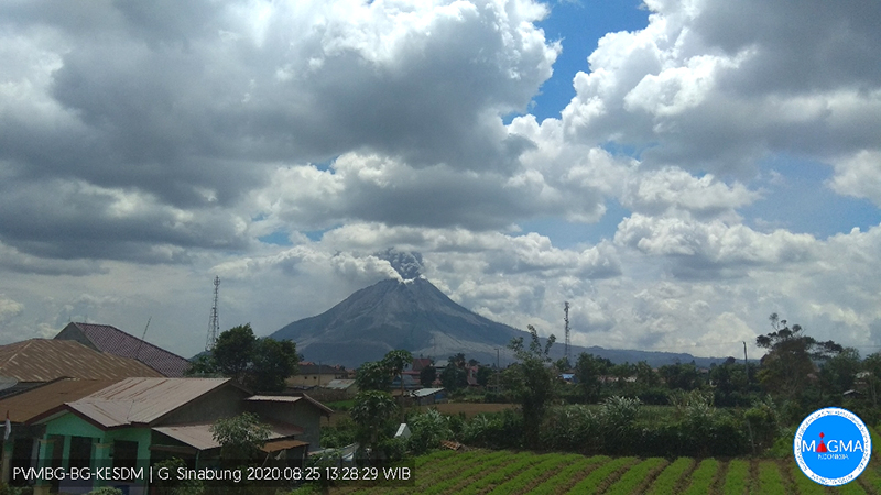 |
Figure 79. An explosion on 25 August 2020 at Sinabung produced an ash plume that rose 800 m above the peak and drifted W and NW. Courtesy of PVMBG (Sinabung Eruption Notice, 25 August 2020). |
Explosive activity decreased substantially during September 2020. A single explosion reported on 5 September produced a white and brown ash plume that rose 800 m above the summit and drifted NNE. During the rest of the month steam emissions rose 50-500 m above the summit before dissipating. Two lahars were reported on 7 September, and one each on 11 and 30 September. Although only a single explosion was reported, anomalous SO2 emissions were present in satellite data on several days.
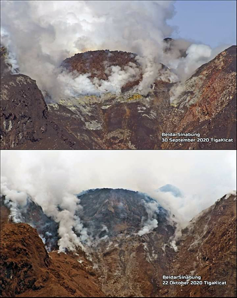
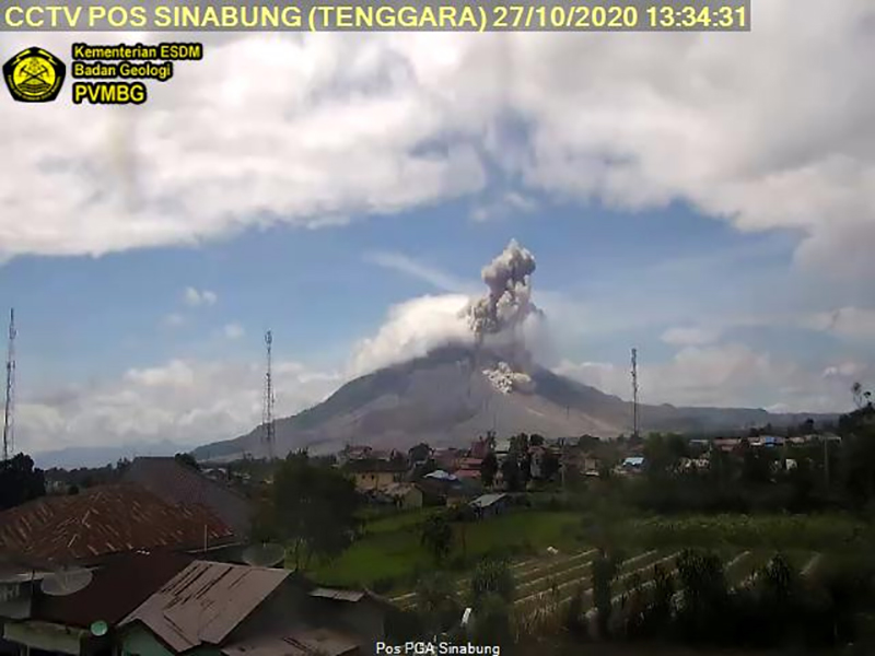
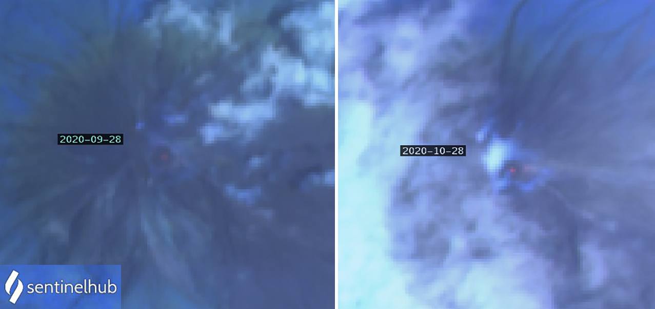
The character of the activity changed during October 2020. Steam plumes rising 50-300 m above the summit were reported during the first week and a lahar was recorded by seismometers on 4 October. The first block avalanches from a new dome growing at the summit were reported on 8 October with material traveling 300 m ESE from the summit (figure 81). During 11-13 October block avalanches traveled 300-700 m E and SE from the summit. They traveled 100-150 m on 14 October. Steam plumes rising 50-500 m above the summit were reported during 15-22 October with two lahars recorded on 21 October. White and gray emissions rose 50-1,000 m on 23 October. The first of a series of pyroclastic flows was reported on 25 October; they were reported daily through the end of the month when the weather permitted, traveling 1,000-2,500 m from the summit (figure 82). In addition, block avalanches from the growing dome were observed moving down the E and SE flanks 500-1,500 m on 25 October and 200-1,000 m each day during 28-31 October (figure 83). Sentinel-2 satellite data indicated a very weak thermal anomaly at the summit in late September; it was slightly larger in late October, corroborating with images of the slow-growing dome (figure 84).
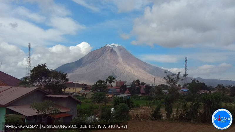 |
Figure 83. Block avalanches from the growing summit dome at Sinabung descended the SE flank on 28 October 2020. The dome is visible at the summit. Courtesy of PVMBG and MAGMA. |
Geological Summary. Gunung Sinabung is a Pleistocene-to-Holocene stratovolcano with many lava flows on its flanks. The migration of summit vents along a N-S line gives the summit crater complex an elongated form. The youngest crater of this conical andesitic-to-dacitic edifice is at the southern end of the four overlapping summit craters. The youngest deposit is a SE-flank pyroclastic flow 14C dated by Hendrasto et al. (2012) at 740-880 CE. An unconfirmed eruption was noted in 1881, and solfataric activity was seen at the summit and upper flanks in 1912. No confirmed historical eruptions were recorded prior to explosive eruptions during August-September 2010 that produced ash plumes to 5 km above the summit.
Information Contacts: Pusat Vulkanologi dan Mitigasi Bencana Geologi (PVMBG, also known as Indonesian Center for Volcanology and Geological Hazard Mitigation, CVGHM), Jalan Diponegoro 57, Bandung 40122, Indonesia (URL: http://www.vsi.esdm.go.id/); Badan Nasional Penanggulangan Bencana (BNPB), National Disaster Management Agency, Graha BNPB - Jl. Scout Kav.38, East Jakarta 13120, Indonesia (URL: http://www.bnpb.go.id/); Darwin Volcanic Ash Advisory Centre (VAAC), Bureau of Meteorology, Northern Territory Regional Office, PO Box 40050, Casuarina, NT 0811, Australia (URL: http://www.bom.gov.au/info/vaac/); Sentinel Hub Playground (URL: https://www.sentinel-hub.com/explore/sentinel-playground); Global Sulfur Dioxide Monitoring Page, Atmospheric Chemistry and Dynamics Laboratory, NASA Goddard Space Flight Center (NASA/GSFC), 8800 Greenbelt Road, Goddard, Maryland, USA (URL: https://so2.gsfc.nasa.gov/); The Jakarta Post, 3rd Floor, Gedung, Jl. Palmerah Barat 142-143 Jakarta 10270 (URL: https://www.thejakartapost.com/amp/news/2020/08/08/mount-sinabung-erupts-again-after-year-of-inactivity.html);Rizal (URL: https://twitter.com/Rizal06691023/status/1319452375887740930); CultureVolcan (URL: https://twitter.com/CultureVolcan/status/1321156861173923840).

