Report on Lewotolok (Indonesia) — February 2021
Bulletin of the Global Volcanism Network, vol. 46, no. 2 (February 2021)
Managing Editor: Edward Venzke.
Edited by Kadie L. Bennis.
Lewotolok (Indonesia) New eruption in late November 2020 consisting of ash plumes, crater incandescence, and ashfall
Please cite this report as:
Global Volcanism Program, 2021. Report on Lewotolok (Indonesia) (Bennis, K.L., and Venzke, E., eds.). Bulletin of the Global Volcanism Network, 46:2. Smithsonian Institution. https://doi.org/10.5479/si.GVP.BGVN202102-264230
Lewotolok
Indonesia
8.274°S, 123.508°E; summit elev. 1431 m
All times are local (unless otherwise noted)
Lewotolok (also known as Lewotolo) is located on the eastern end of a peninsula connected to Lembata (formerly Lomblen) that extends north into the Flores Sea. Eruptions date back to 1660, characterized by explosive activity in the summit crater. Typical activity has consisted of seismicity and thermal anomalies near the summit crater (BGVN 36:12 and 41:09). A new eruption that began in late November 2020 was characterized by increased seismicity, dense, gray ash plumes, nighttime crater incandescence, and ashfall. This report covers activity through January 2021 using information primarily from the Pusat Vulkanologi dan Mitigasi Bencana Geologi (PVMBG, also known as CVGHM, or the Center of Volcanology and Geological Hazard Mitigation), MAGMA Indonesia, and satellite data.
Summary of activity during February 2012-October 2020. Activity from February 2012 to November 2020 was relatively low and consisted primarily of a persistent thermal anomaly in the summit crater since at least March 2016 and occasional white gas-and-steam emissions. During January 2012 intermittent white gas-and-steam plumes rose 15-500 m above the crater, accompanied by crater incandescence; no thermal anomalies were reported during 16-24 January. On 6 January there were 500 people in the Lembata district evacuated due to reports of ash plumes that were observed by local residents, the smell of sulfur, and the sound of rumbling (BGVN 36:12).
Thermal activity dates back to 13 October 2014 using MODIS data in MODVOLC satellite data (BGVN 41:09; figure 3). According to the MODVOLC algorithm, a total of seven thermal alerts were detected on 13 October 2014 (1), 27 September 2015 (1), 2, 3, and 4 (2) October 2015, and 5 November 2017 (1). The number of thermal alerts in both MODVOLC and Sentinel-2 satellite data had increased slightly in 2020 compared to 2018 and 2019, though cloud cover often prevented visual confirmation for the latter (figure 3). Sentinel-2 thermal satellite imagery captured occasional thermal anomalies in the summit crater during 2016-2019 (figure 4). White gas-and-steam plumes were intermittently reported from September 2017 through 2 March 2018 that rose as high as 500 m above the crater and drifted dominantly E and W, according to PVMBG.
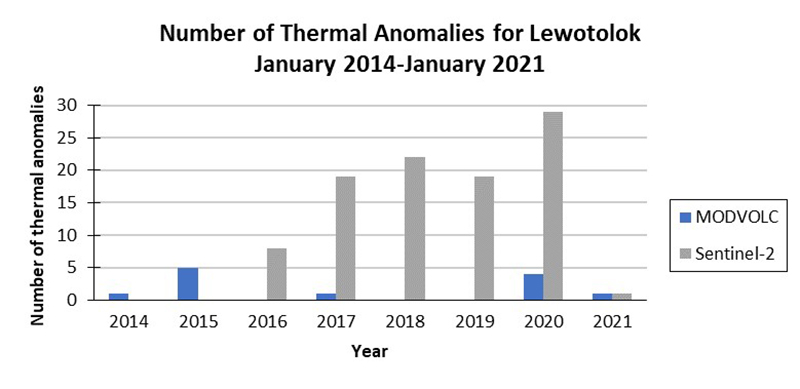 |
Figure 3. Graph comparing the number of thermal anomalies using MODVOLC alerts and Sentinel-2 satellite data for Lewotolok during January 2014-January 2021 for MODVOLC and 20 March 2016-January 2021 for Sentinel-2 thermal satellite data. Data courtesy of HIGP - MODVOLC Thermal Alerts System and Sentinel Hub Playground. |
Brief seismicity, which included shallow and deep volcanic earthquakes was detected during October 2017. On 9 October 2017 PVMBG issued a VONA (Volcano Observatory Notice for Aviation) reporting that white gas-and-steam emissions rose 500 m above the crater. On 10 October BNPB (Badan Nacional Penanggulangan Bencana) reported that five earthquakes 10-30 km below Lewotolok and ranging in magnitude of 3.9-4.9 as recorded by Badan Meteorologi, Klimatologi, dan Geofisika (BMKG). These seismic events were felt by local populations and resulted in an evacuation of 723 people. The only activity reported between January 2018 and October 2020 was white gas-and-steam plumes that rose 5-100 m above the crater drifting primarily E and W and an occasional thermal anomaly in the summit crater (figure 4).
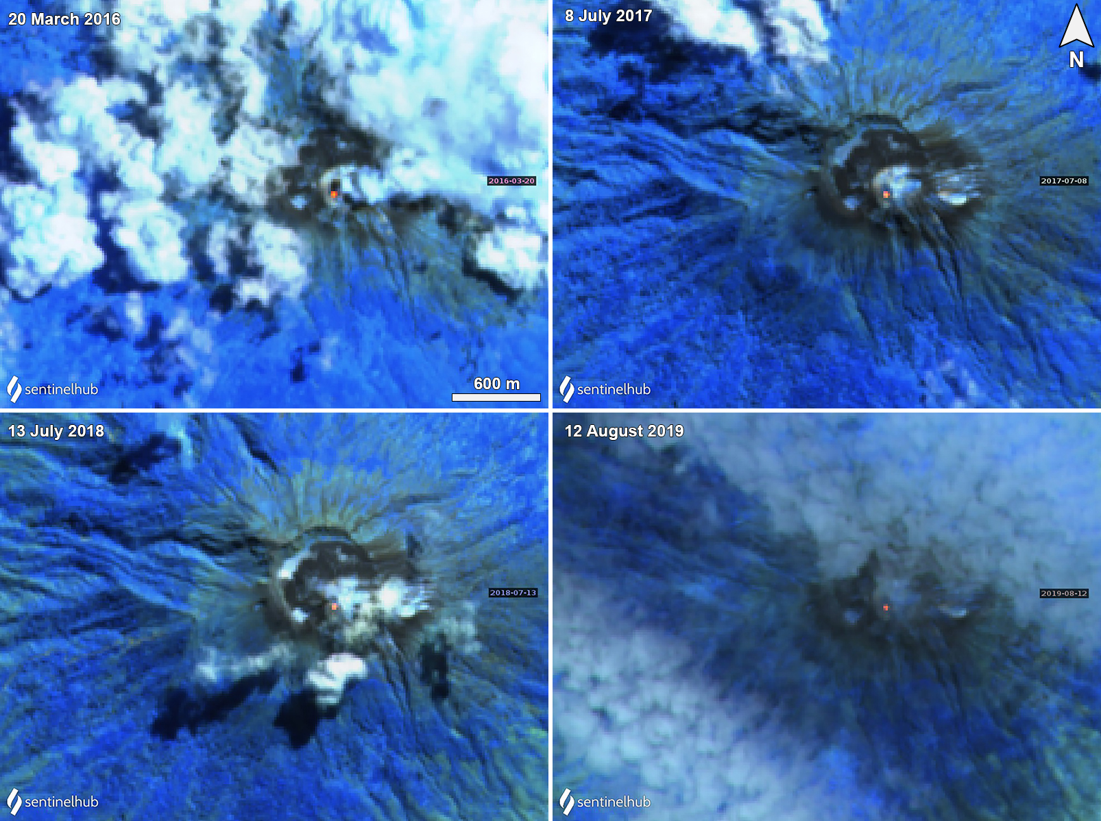 |
Figure 4. Sentinel-2 thermal satellite imagery shows a thermal anomaly in the summit crater of Lewotolok during 20 March 2016 (top left), 8 July 2017 (top right), 13 July 2018 (bottom left), and 12 August 2019 (bottom right). Sentinel-2 satellite images with “Atmospheric penetration” (bands 12, 11, 8A) rendering. Courtesy of Sentinel Hub Playground. |
New eruption starting in November 2020. On 26 November 2020 a continuous tremor began at 1943, followed by a series of volcanic earthquakes at 1947 and deep volcanic earthquakes at 1951, 1952, 1953, and 2255; white gas-and-steam emissions rose 20 m above the crater. Deep volcanic earthquakes were again recorded at 0242, 0537, 0556 on 27 November. At 0557 an explosion produced a gray ash plume that rose 500 m above the crater and drifted W; by 0630 the plume turned white, according to PVMBG (figure 5). Seismicity decreased slightly after the explosion, but tremor continued. During 27-28 November dense white gas-and-steam plumes rose as high as 500 m above the crater and nighttime crater incandescence was observed.
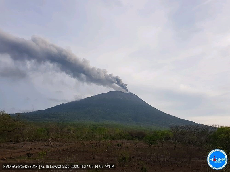 |
Figure 5. Webcam image of a dense gray ash plume rising 500 m above the crater of Lewotolok on 27 November 2020. Courtesy of MAGMA Indonesia. |
During the morning of 29 November seismicity increased again and consisted of six deep volcanic earthquakes, continuous tremor occurred around 0930. A second explosion was recorded at 0945 that produced an ash plume 4 km above the crater, accompanied by incandescent material that was ejected above the crater (figure 6). The ash plume consisted of two levels: the lower-level drifted W and NW and the upper-level drifted E and SE. The large, gray ash plume was captured in a satellite image as it spread generally E and W (figure 7). Ashfall and a sulfur odor was reported in several surrounding villages; videos from social media showed tephra falling onto the roofs of residential areas. BPBD evacuated residents in 28 villages in two sub-districts; by 29 November at 1300 about 900 people had been evacuated. At 1900 Strombolian activity was observed and during the night, crater incandescence was visible.
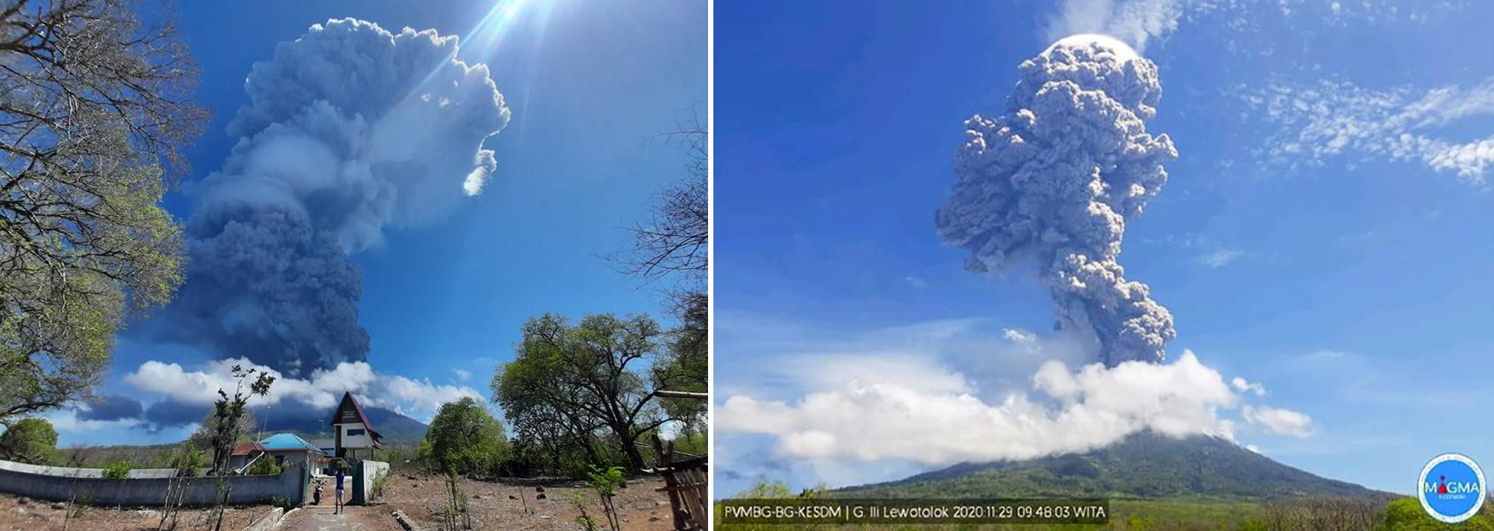 |
Figure 6. Photos of the eruption at Lewotolok on 29 November 2020 that produced a dense, gray ash plume 4 km above the crater. Courtesy of Devy Kamil Syahbana, PVMBG (left) and MAGMA Indonesia (right). |
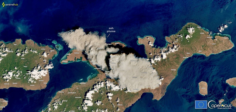 |
Figure 7. Satellite image showing a strong gray ash plume above Lewotolok on 29 November 2020, expanding roughly E and W. Courtesy of Sentinel Hub Playground and the European Space Agency, Copernicus. |
The eruption continued from 29 November into 1 December, where the white-and-gray ash plumes rose 700-2,000 m above the crater and drifted SE and W, accompanied by incandescent material that was ejected above the crater and the smell of sulfur, according to PVMBG (figure 8). A large sulfur dioxide plume was reported drifting SE and extending over the N half of Australia by 30 November (figure 9). By 1300 that day, 4,628 people had been evacuated. Incandescent lava flows near the summit were visible and incandescent material traveled down the flanks during 30 November and 1 December.
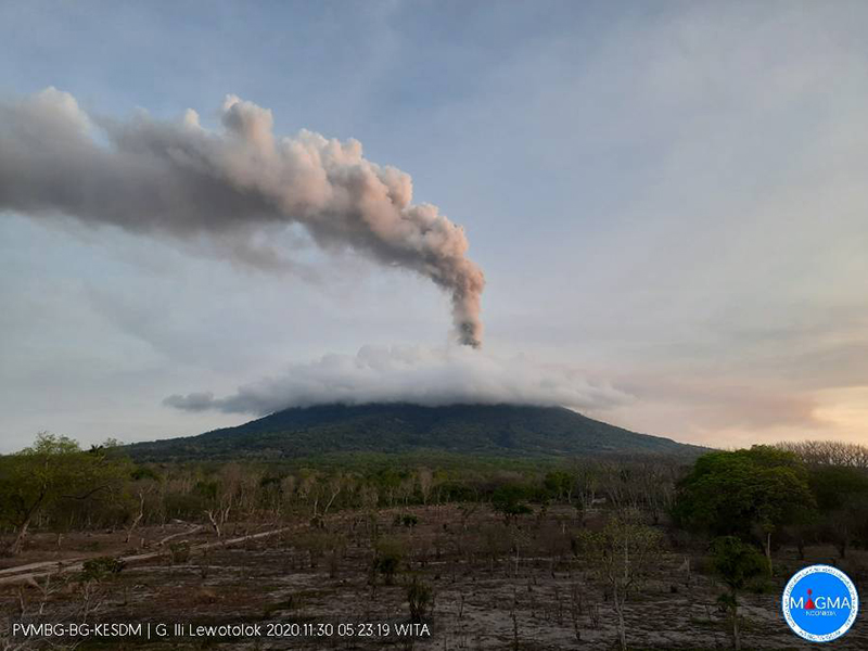 |
Figure 8. Webcam image of the continuous eruption at Lewotolok showing a dense gray ash plume rising above the cloud-covered summit on 30 November 2020. Courtesy of MAGMA Indonesia. |
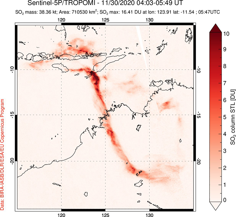 |
Figure 9. SO2 plume from Lewotolok captured by the Sentinel-5P/TROPOMI instrument on 30 November 2020 drifting SE and along the N part of Australia. Courtesy of Simon Carn and the NASA Global Sulfur Dioxide Monitoring Page. |
White-and-gray plumes continued frequently through January 2021, rising 100-1,500 m above the crater, drifting in multiple directions, accompanied by nighttime crater incandescence and occasional incandescent ejecta (figure 10). During 1-8 December gray plumes rose 100-1,000 m above the crater and drifted E, W, and SW accompanied by nightly crater incandescence and incandescent material ejected as high as 20 m above the crater. By 5 December at 2200 about 9,028 residents had been evacuated to 11 evacuation centers, according to BNPB. Black, gray, and brown ash plumes were visible daily during 9-15 December, rising 1 km above the crater, accompanied by nightly Strombolian explosions that ejected material above the crater. More Strombolian explosions on most nights over 16-29 December ejected material 100-300 m above the crater; in addition, the sounds of rumbling and banging could be heard. The material was deposited as far as 1 km from the crater E and SE during 24-25 and 27-31 December and 4-7 January 2021. Strombolian activity continued into January, accompanied by frequent gray-and-white ash plumes, rumbling and banging sounds, and incandescent ejecta up to 600 above the crater that extended as far as 500 m E, SE, and W. Crater incandescence was visible up to 600 m above the crater.
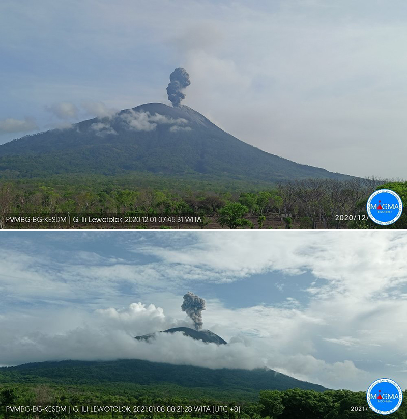 |
Figure 10. Webcam images showing continuing dense gray ash plumes from Lewotolok on 1 December 2020 (top) and 8 January 2021 (bottom). Courtesy of MAGMA Indonesia. |
A consistent level of thermal activity was recorded in the Sentinel-2 MODIS Thermal Volcanic Activity from February 2019 through October 2020; in early December 2020 a slight increase in thermal anomalies were detected (figure 11). This data reflects the start of the new eruption in late November 2020. According to the MODVOLC thermal algorithm, five thermal hotspots were detected between January 2020 and January 2021 on 3 September (1), 29 November (2), 24 December (1), and 5 January 2021 (1). Some of this thermal activity was also observed in Sentinel-2 thermal satellite imagery in the summit crater (figure 12).
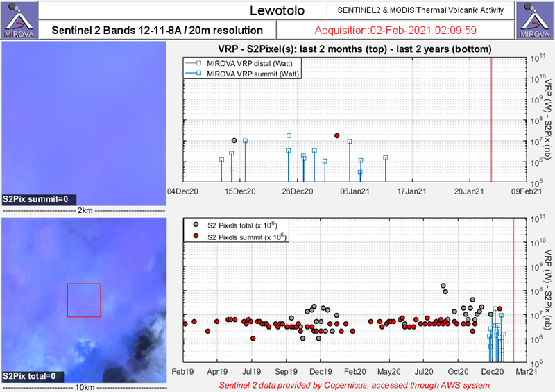 |
Figure 11. Sentinel-2 MODIS Thermal Volcanic Activity data (bands 12, 11, 8A) shows consistent thermal activity (red dots) at Lewotolok during February 2020 through December 2020. Stronger thermal anomalies in early December is likely due to the new eruption that began in late November 2020. Courtesy of MIROVA. |
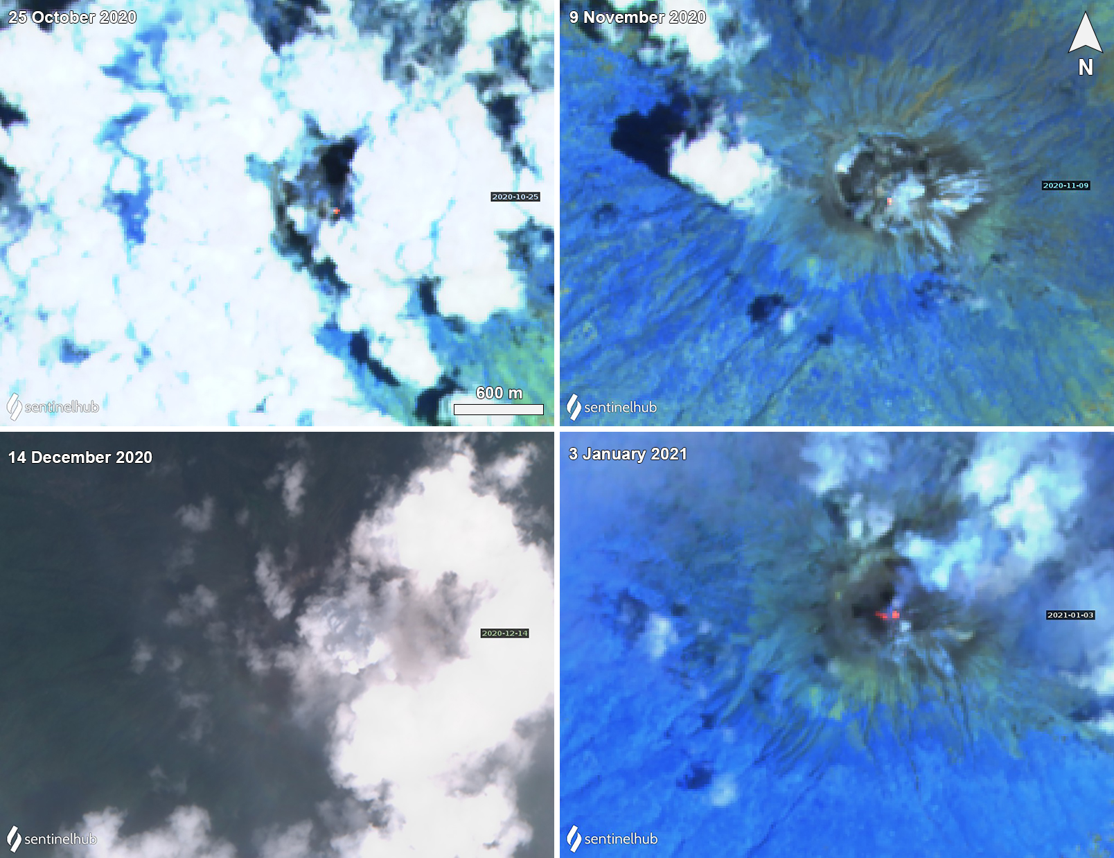 |
Figure 12. Sentinel-2 thermal satellite imagery showing a thermal anomaly in the summit crater of Lewotolok on 25 October (top left), 9 November (top right), and 3 January 2021 (bottom right). On 14 December (bottom left) a Natural Color image showed a gray ash emission above the clouds and drifted E. On 3 January 2021 (bottom right) two thermal anomalies were visible in the summit crater accompanied by gas-and-steam emissions drifting NE. Sentinel-2 satellite images with “Natural Color” rendering (bands 4, 3, 2) on 14 December 2020, all other images use “Atmospheric penetration” (bands 12, 11, 8A) rendering. Courtesy of Sentinel Hub Playground. |
Geological Summary. The Lewotolok (or Lewotolo) stratovolcano occupies the eastern end of an elongated peninsula extending north into the Flores Sea, connected to Lembata (formerly Lomblen) Island by a narrow isthmus. It is symmetrical when viewed from the north and east. A small cone with a 130-m-wide crater constructed at the SE side of a larger crater forms the volcano's high point. Many lava flows have reached the coastline. Eruptions recorded since 1660 have consisted of explosive activity from the summit crater.
Information Contacts: Pusat Vulkanologi dan Mitigasi Bencana Geologi (PVMBG, also known as Indonesian Center for Volcanology and Geological Hazard Mitigation, CVGHM), Jalan Diponegoro 57, Bandung 40122, Indonesia (URL: http://www.vsi.esdm.go.id/); Badan Nasional Penanggulangan Bencana (BNPB), National Disaster Management Agency, Graha BNPB - Jl. Scout Kav.38, East Jakarta 13120, Indonesia (URL: http://www.bnpb.go.id/); MAGMA Indonesia, Kementerian Energi dan Sumber Daya Mineral (URL: https://magma.vsi.esdm.go.id/); MIROVA (Middle InfraRed Observation of Volcanic Activity), a collaborative project between the Universities of Turin and Florence (Italy) supported by the Centre for Volcanic Risk of the Italian Civil Protection Department (URL: http://www.mirovaweb.it/); Hawai'i Institute of Geophysics and Planetology (HIGP) - MODVOLC Thermal Alerts System, School of Ocean and Earth Science and Technology (SOEST), Univ. of Hawai'i, 2525 Correa Road, Honolulu, HI 96822, USA (URL: http://modis.higp.hawaii.edu/); Sentinel Hub Playground (URL: https://www.sentinel-hub.com/explore/sentinel-playground); European Space Agency (ESA), Copernicus (URL: http://www.esa.int/Our_Activities/Observing_the_Earth/Copernicus); NASA Global Sulfur Dioxide Monitoring Page, Atmospheric Chemistry and Dynamics Laboratory, NASA Goddard Space Flight Center (NASA/GSFC), 8800 Greenbelt Road, Goddard, Maryland, USA (URL: https://so2.gsfc.nasa.gov/); Simon Carn, Dept of Geological and Mining Engineering and Sciences, Michigan Technological University, 1400 Townsend Dr., Houghton, MI 49931, USA (URL: https://so2.gsfc.nasa.gov/).