Report on Santa Maria (Guatemala) — February 2021

Bulletin of the Global Volcanism Network, vol. 46, no. 2 (February 2021)
Managing Editor: Edward Venzke.
Edited by Janine B. Krippner.
Santa Maria (Guatemala) Frequent explosions and avalanches August 2020-January 2021; lava extrusion in September 2020
Please cite this report as:
Global Volcanism Program, 2021. Report on Santa Maria (Guatemala) (Krippner, J.B., and Venzke, E., eds.). Bulletin of the Global Volcanism Network, 46:2. Smithsonian Institution. https://doi.org/10.5479/si.GVP.BGVN202102-342030
Santa Maria
Guatemala
14.757°N, 91.552°W; summit elev. 3745 m
All times are local (unless otherwise noted)
Santa Maria is one of the most active volcanoes in Guatemala. Major features are the Santa Maria edifice with the large crater that formed in the 1902 eruption, and the Santiaguito dome complex about 2.5 km down the SW flank that includes the currently active Caliente dome (figure 113). Activity typically includes ash plumes, gas emissions, lava extrusion, and avalanches. This report summarizes activity during August 2020 through January 2021 and is based on reports by Instituto Nacional de Sismología, Vulcanología, Meteorología e Hidrología (INSIVUMEH), Coordinadora Nacional para la Reducción de Desastres (CONRED), and satellite data.
 |
Figure 113. Main features of the Santa Maria complex are shown in this March 2021 Planet Labs satellite image monthly mosaic. The large scarp is the wall of the crater produced during the 1902 eruption. Within that the El Brujo, El Monje, La Mitad domes, and the currently active Caliente dome, are from W to E. Courtesy of Planet Labs. |
Throughout August weak to moderate explosions were reported most days, some days occurring 2-4 times per hour. These produced ash plumes to an altitude of 3.5 km, typically reaching 3.4 km. The plumes were dispersed mostly W and SW, sometimes S, SE, and NW. Degassing was reported throughout the month, with plumes reaching 3.5 km, but most often 3-3.1 km altitude. On the 3rd, ashfall was reported in San Marcos Palajuno (8 km SW), Loma Linda (6 km WSW) and others in that direction, and again on the 29th. It was also reported in Monte Claro (S of the summit) on the 12th and light ashfall occurred on the flanks through the month. Explosions on the 23rd produced weak pyroclastic flows that traveled down the SW flank of the dome. The activity produced frequent avalanches on the S, SW, and SE flanks of the dome, some reaching the base of the dome and some depositing fine ash onto the flanks. The sound of explosions and degassing were reported most days and incandescence was frequently seen at the crater at night.
This activity continued through September, maintaining the same eruptive pattern of weak and moderate explosions, gas emission, lava extrusion, and avalanches. Incandescence continued to be visible at the crater. There was ashfall reported in Monte Claro, Aldea San Marcos Palajunoj and other surrounding communities on the 7th, Monte Claro on the 11th, and across the Palajunoj area on the 28th. On the afternoon of 25 September lahars occurred in the Cabello de Ángel and Nimá I drainages. Lava extrusion was reported on the morning of the 29th along with resulting block-and-ash flows.
Throughout October explosions, gas emission, avalanches, and elevated crater temperatures producing nighttime incandescence (figure 114) continued in the same manner as the previous months. From the 9th the extrusion of lava was observed over the dome, generating block-and-ash flows mainly down the W flank. Ashfall was reported in of Loma Linda and El Rosario Palajunoj and others in the area on the 13th, 7 km SW on the 18th, and in San Marcos Palajunoj and nearby areas on the 23rd. Lava extrusion generated constant avalanches down multiple flanks from the 23rd, with some producing small ash plumes as they descended.
 |
Figure 114. This Shortwave Infrared (SWIR) image of Santa Maria acquired on 19 October by the Landsat 8 satellite shows elevated temperatures at the Caliente dome. The contour intervals are 30 m. Courtesy of USGS and INSIVUMEH. |
Throughout November gas emissions and explosions continued to produce gas-and-steam and ash plumes that rose up to 3.4 km altitude. Lava extrusion also continued down the W flank, producing incandescence and frequent avalanches down the SE, S, SW, and W flanks, as well as less frequent block-and-ash flows (figure 115). An increase in thermal energy detected towards the end of the month resulted from this extrusion (figure 116). Ashfall occurred around the volcano from explosions and avalanches. Ashfall was reported SE within the villages of Las Marías, Calaguache and others nearby on the 12th and 22nd, and SSW over the village of San Marcos Palajunoj, Loma Linda and Fincas in the Palajunoj area on the 27th. Degassing and explosions were intermittently heard in nearby communities with reports of sounds similar to an airplane turbine. An explosion on the 16th produced an ash plume up to 3.6 km altitude and pyroclastic flows down the flanks (figure 117).
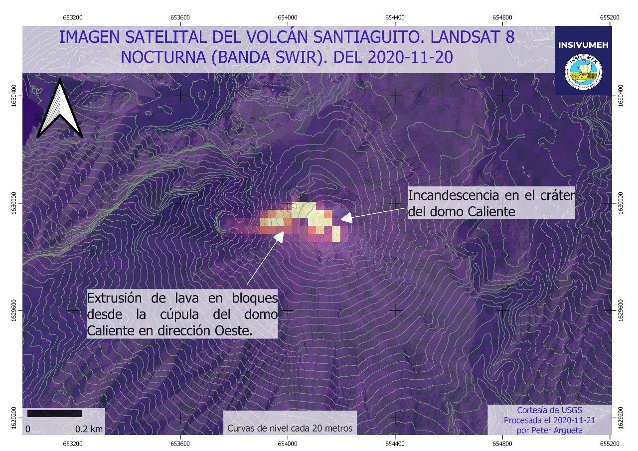 |
Figure 115. This nighttime Landsat 8 Shortwave Infrared (SWIR) satellite image of Santa Maria with the contours of the Caliente dome overlain was acquired on 20 November 2020. There are elevated temperatures within the summit crater and lava is flowing down a channel on the western flank. The contour intervals are 20 m. Courtesy of USGS and INSIVUMEH. |
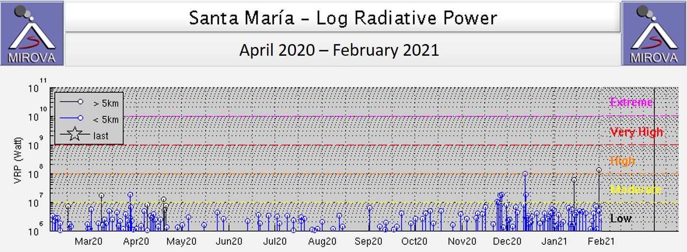 |
Figure 116. This MIROVA log radiative power plot shows the thermal energy released at Santa Maria between April 2020 to February 2021. There was a decrease in energy emitted from May to November, followed by an increase in the frequency and the energy released on some days. The black vertical lines like the two in January-February are more than 5 km from the summit and are likely not a result of volcanic activity. Courtesy of MIROVA. |
 |
Figure 117. An explosion from the Caliente dome of Santa Maria is seen here at 0715 on 16 November 2020. The photo shows the ash plume that rose to 3.6 km altitude and pyroclastic flows descending the flanks. The seismogram shows the explosion in the center of the bottom line (the times on the left are given in UTC). Courtesy of INSIVUMEH. |
Gas emissions and weak to moderate explosions continued throughout December, producing plumes reaching 3.4 km altitude along with ongoing lava extrusion producing avalanches (figures 118 and 119). Ash from explosions and avalanches was intermittently emplaced onto the flanks, and ashfall was reported in the villages of San Marcos and Loma Linda Palajunoj on the 7th, and in Loma Linda and Finca Montebello on the 11th. Activity increased from 0430 on 11 December 2020 with the generation of moderate to powerful avalanches as well as block-and-ash flows from lava extrusion and accumulation, with 13 events recorded between that time and when a report was released at 0900. The intensity continued with block-and-ash flows and pyroclastic flows moving down the W and SW flanks that generated ash plumes which extended 20 km downwind.
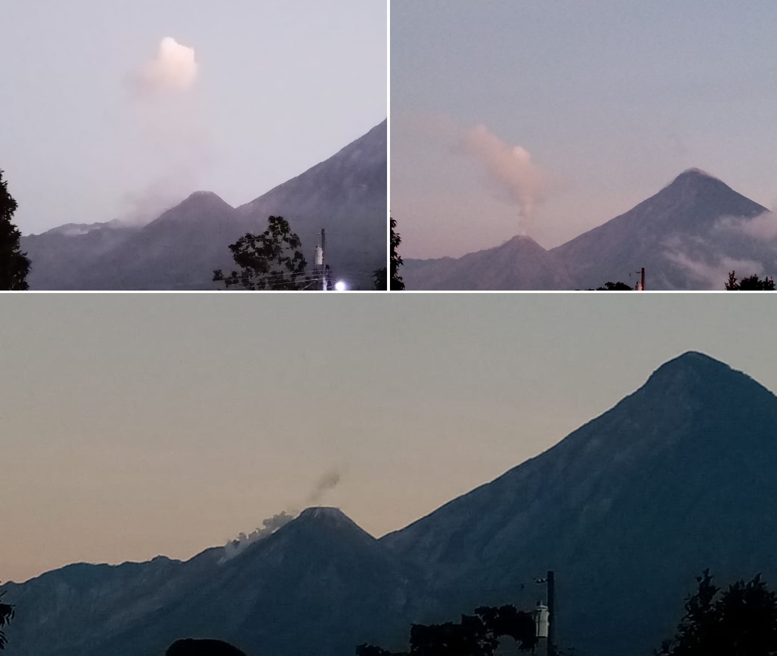 |
Figure 118. Plumes rise from the Caliente dome at Santa Maria on 9 (top left) and 15 (top right) December 2020. A faint plume rises from the summit of the Caliente dome and another plume rises from a possible avalanche down the SW flank (bottom). Courtesy of INSIVUMEH (Fotografías Recientes de Volcanes). |
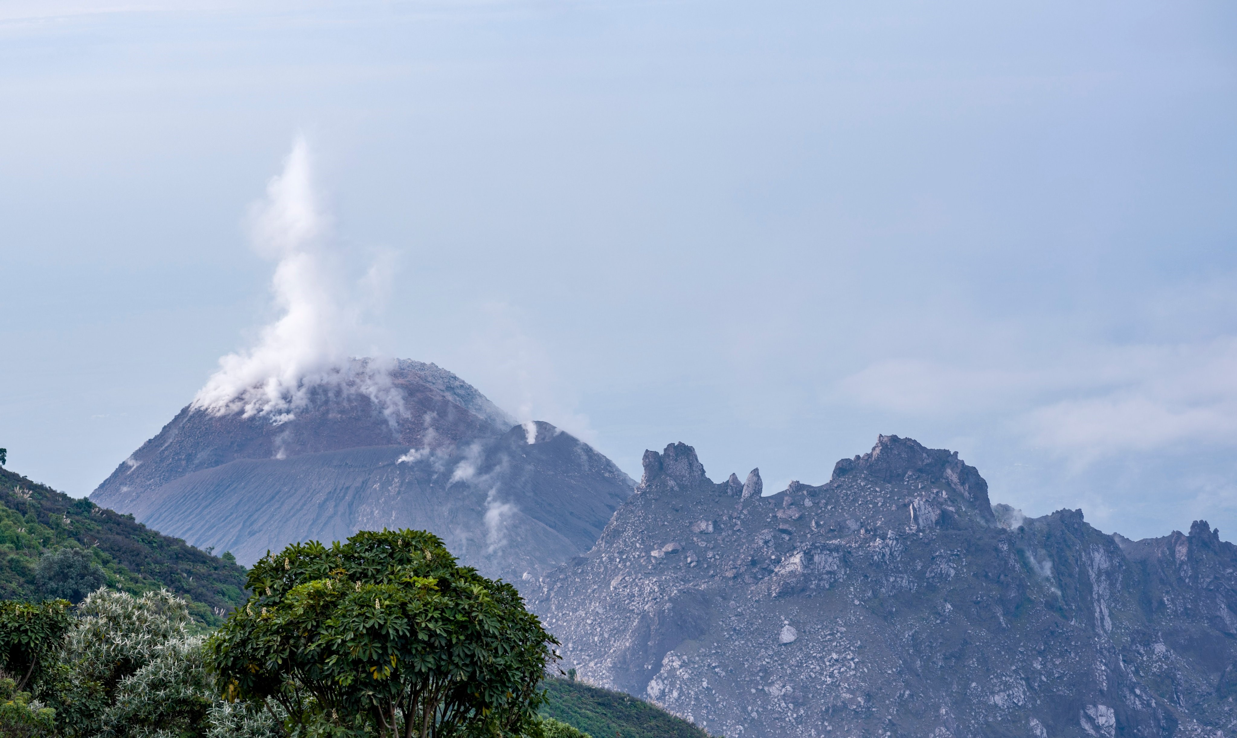 |
Figure 119. A gas-and-steam plume rises from the degassing Caliente dome at Santa Maria on 30 December 2020. Around this time weak and moderate explosions produced ash plumes up to 3-3.4 km altitude, resulting in ashfall on the flanks. Courtesy of CONRED. |
The high level of background activity associated with lava extrusion continued through January. Satellite images show the lava flow advancing down the W-flank channel (figure 120), reaching approximately 250 m by the 11th. Avalanches also continued, producing ash that was emplaced nearby (figure 121). On the 22nd the collapse of dome material produced a pyroclastic flow to the E and SE. Explosions ejected ash to 3.4 km altitude, with ashfall that was reported in the Aldeas de San Marcos and Loma Linda Palajunoj on the 1st, Aldeas de San Marcos and Loma Linda Palajunoj on the 11th, Aldeas de San Marcos y Loma Linda Palajunoj, Fca. El Patrocinio during the 20-21st. Ashfall was again reported on the 31st to the west on farms, in Aldeas de San Marcos, and in Loma Linda Palajunoj. Sounds generated by explosions were sometimes heard around 10 km away.
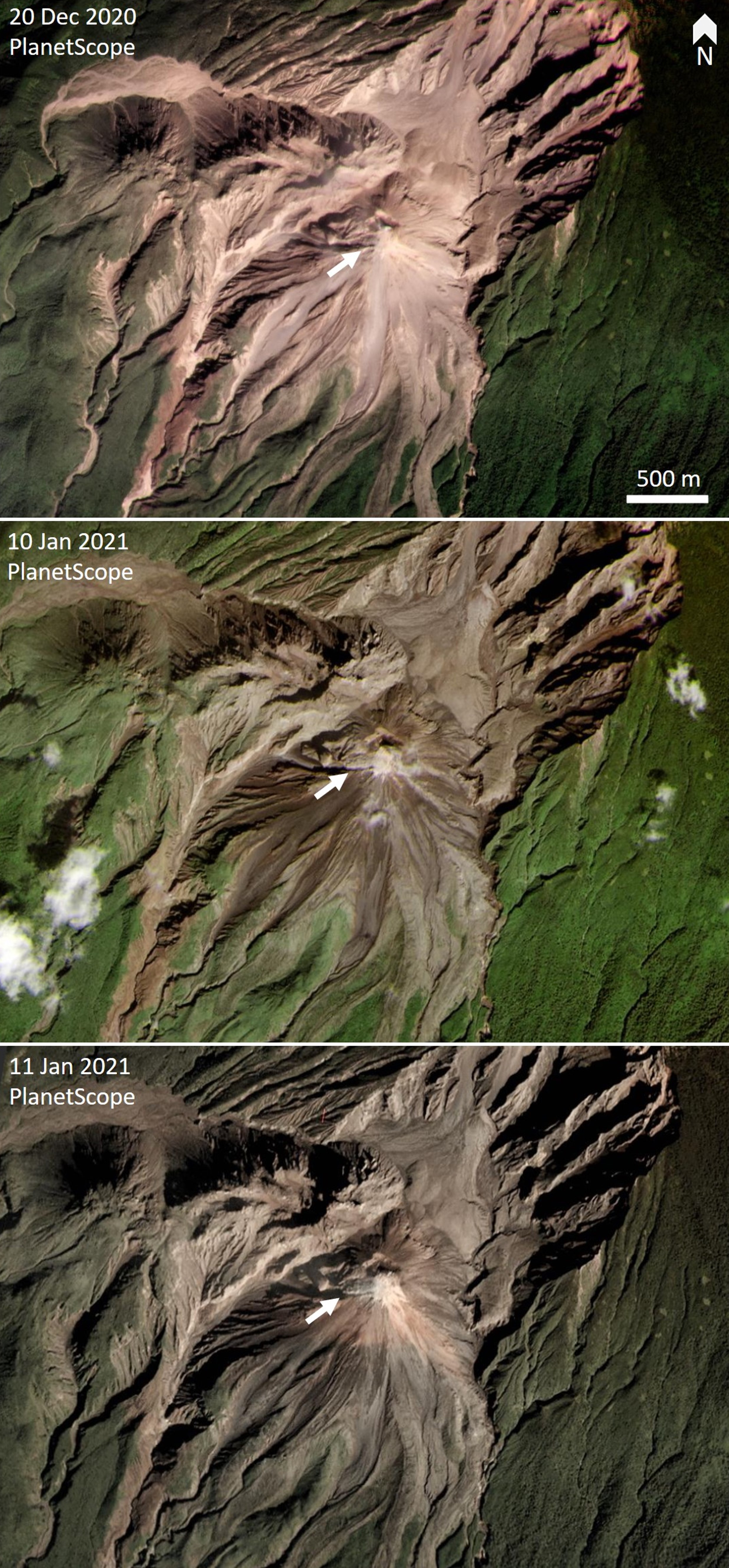 |
Figure 120. PlanetScope satellite images of Santa Maria acquired on 20 December 2020 and 10 and 11 January 2021 show the development of a lava flow down a channel on the W flank (white arrows). In the latest image the flow is approximately 250 m long. Courtesy of Planet Labs. |
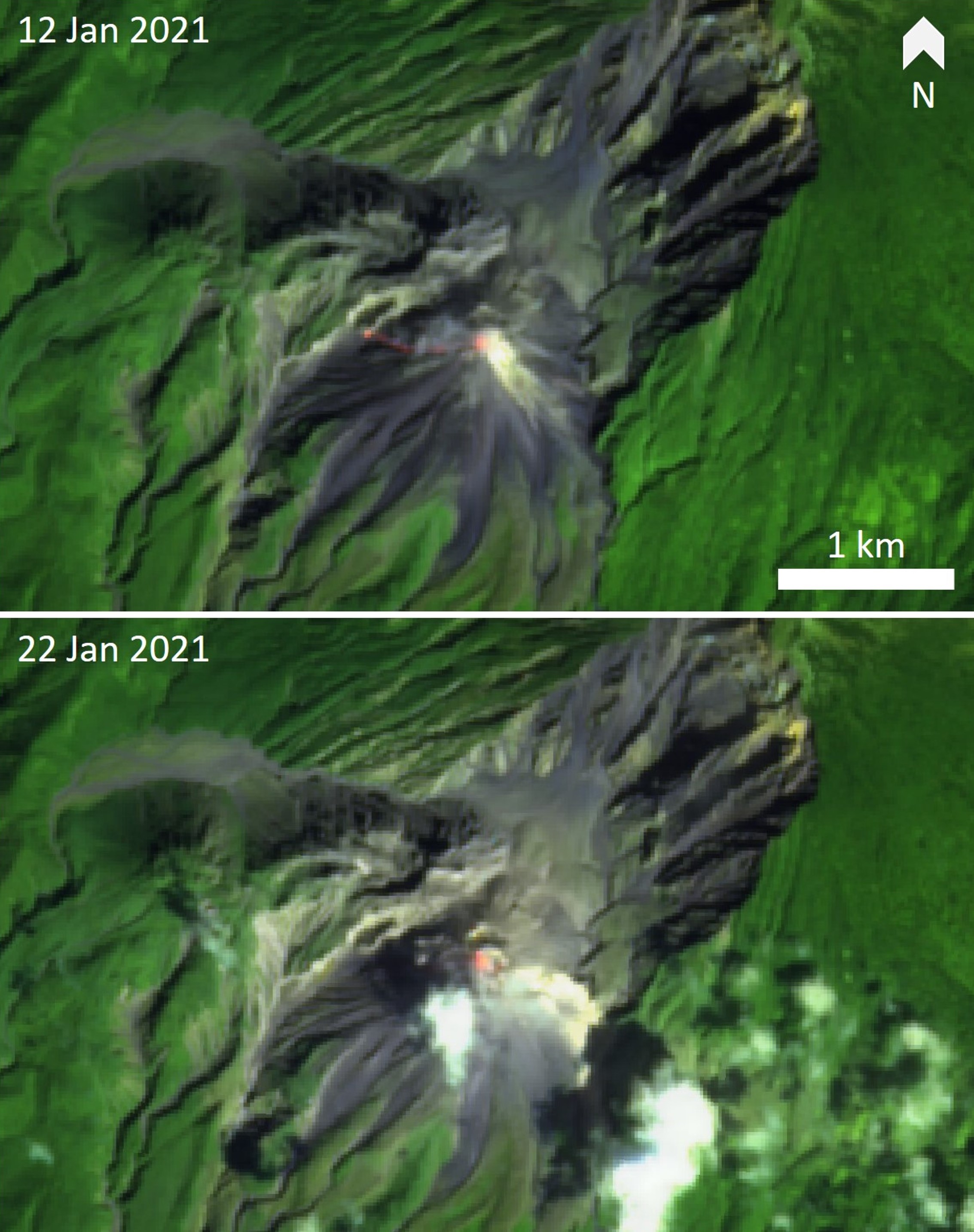 |
Figure 121. Thermal infrared satellite images of Santa Maria acquired on 12 and 22 January 2021 show higher temperatures on the Caliente dome. Top: Elevated thermal areas are detected at the summit and hot material is emplaced down the W-flank channel. Bottom: Elevated temperatures at the summit of the lava dome, with a possible avalanche on the E flank. Sentinel-2 thermal satellite images with false color (urban) (bands 12, 11, 4) rendering. Courtesy of Sentinel Hub Playground. |
Geological Summary. Symmetrical, forest-covered Santa María volcano is part of a chain of large stratovolcanoes that rise above the Pacific coastal plain of Guatemala. The sharp-topped, conical profile is cut on the SW flank by a 1.5-km-wide crater. The oval-shaped crater extends from just below the summit to the lower flank, and was formed during a catastrophic eruption in 1902. The renowned Plinian eruption of 1902 that devastated much of SW Guatemala followed a long repose period after construction of the large basaltic andesite stratovolcano. The massive dacitic Santiaguito lava-dome complex has been growing at the base of the 1902 crater since 1922. Compound dome growth at Santiaguito has occurred episodically from four vents, with activity progressing E towards the most recent, Caliente. Dome growth has been accompanied by almost continuous minor explosions, with periodic lava extrusion, larger explosions, pyroclastic flows, and lahars.
Information Contacts: Instituto Nacional de Sismologia, Vulcanologia, Meteorologia e Hydrologia (INSIVUMEH), Unit of Volcanology, Geologic Department of Investigation and Services, 7a Av. 14-57, Zona 13, Guatemala City, Guatemala (URL: http://www.insivumeh.gob.gt/); Coordinadora Nacional para la Reducción de Desastres (CONRED), Av. Hincapié 21-72, Zona 13, Guatemala City, Guatemala (URL: http://conred.gob.gt/www/index.php); MIROVA (Middle InfraRed Observation of Volcanic Activity), a collaborative project between the Universities of Turin and Florence (Italy) supported by the Centre for Volcanic Risk of the Italian Civil Protection Department (URL: http://www.mirovaweb.it/); Planet Labs, Inc. (URL: https://www.planet.com/); Sentinel Hub Playground (URL: https://www.sentinel-hub.com/explore/sentinel-playground).