Report on Soufriere St. Vincent (Saint Vincent and the Grenadines) — March 2021
Bulletin of the Global Volcanism Network, vol. 46, no. 3 (March 2021)
Managing Editor: Edward Venzke.
Edited by Kadie L. Bennis.
Soufriere St. Vincent (Saint Vincent and the Grenadines) New lava dome on the SW edge of the main crater in December 2020
Please cite this report as:
Global Volcanism Program, 2021. Report on Soufriere St. Vincent (Saint Vincent and the Grenadines) (Bennis, K.L., and Venzke, E., eds.). Bulletin of the Global Volcanism Network, 46:3. Smithsonian Institution. https://doi.org/10.5479/si.GVP.BGVN202103-360150
Soufriere St. Vincent
Saint Vincent and the Grenadines
13.33°N, 61.18°W; summit elev. 1220 m
All times are local (unless otherwise noted)
Soufrière St. Vincent is the northernmost stratovolcano on St. Vincent Island in the southern part of the Lesser Antilles. The NE rim of the 1.6-km-wide summit crater is cut by a crater (500 m wide and 60 m depth) that formed in 1812. Recorded eruptions date back to 1718, with notable eruptions occurring in 1812, 1902, and 1979. The eruption of 1979 was characterized by ashfall, pyroclastic flows, and lahars, in addition to a series of Vulcanian explosions during 13-26 April 1979 that destroyed the lava dome in the summit crater, which had formed during a 1971 effusive eruption (SEAN 04:04). As a result, more than 20,000 people were evacuated. Beginning around 3 May 1979 another lava dome began to form in the main crater (SEAN 04:05; Shepherd et al., 1979) that continued to grow until the end of October 1979, expanding to 850 m in diameter and 120 m high (SEAN 04:11; Cole et al., 2019).
No further eruptive activity took place until December 2020, when a new lava dome began to grow SW of the pre-existing 1979 lava dome, accompanied by increased seismicity, crater incandescence, and gas-and-steam emissions. This report reviews information through February 2021 using bulletins from the University of the West Indies Seismic Research Centre (UWI-SRC), the National Emergency Management Organisation (NEMO), and various satellite data. Soufrière St. Vincent is monitored by the SRC assisted by the Soufrière Monitoring Unit (SMU) from the Ministry of Agriculture in Kingstown. As of 2004, the monitoring network had consisted of five seismic stations, eight GPS stations, and several dry tilt sites. Seismic data are transmitted from field sites to the Belmont Observatory (9 km SSW), which is operated by the SMU (figure 4). On 1 January 2021 a new seismic station was installed at Georgetown, on 10 January one was installed in Owia, followed on 15 January by another on the upper S flank, station SSVA at the summit on 18 January, and in Fancy on 21 January. In February 2021 the USGS-USAID (US Geological Survey-US Agency for International Development), through the Volcano Disaster Assistance Program (VDAP), donated equipment to build four more seismic stations.
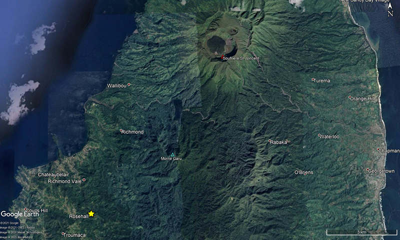 |
Figure 4. Location map of the Belmont Observatory (yellow star) located in Rosehall, St. Vincent, 9 km SSW from the Soufrière St. Vincent summit crater (red triangle). Base map satellite imagery courtesy of Google Earth. |
A spike in seismicity was recorded during June-July 2019 (figure 5), though no cause was reported. The number of events sharply declined after July but continued intermittently through November 2020. Seismicity began to increase in early November through 23 December 2020, which included 126 earthquakes described as volcano-tectonic events and rockfall signals that were captured on one reliable seismic station (SVB) located 9 km from the volcano. The maximum daily count was 11 events on 16 November. After 23 December a total of eight events were detected before seismicity briefly subsided.
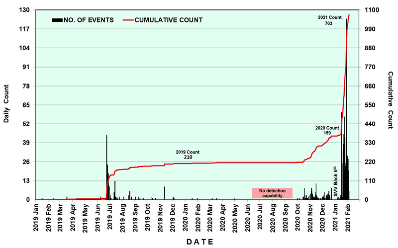 |
Figure 5. Daily count of volcanic earthquakes recorded at Soufrière St. Vincent during 1 January 2019 through February 2021. Increased seismicity was detected during June-July 2019 and mid-October 2020 through February 2021. An installation of station SVV on 6 January 2021 at Wallibou is annotated on this graph. Data courtesy of UWI-SRC. |
Activity during December 2020. Staff members of the Soufrière Monitoring Unit (SMU) made visual observations of the crater on 16 December and reported minor changes in fumarolic activity and a small lake on the E side of the crater floor. On 27 December UWI-SRC and NEMO reported that an effusive eruption had begun, which was characterized by a new lava dome in the main crater on the SW perimeter of the 1979 dome (figures 6 and 7). A thermal hotspot in the crater was also detected that day using satellite data by NASA FIRMS. As a result, the Volcanic Alert Level (VAL) was raised to Orange (the second highest level on a four-color scale) on 29 December (figure 8). The Volcano Ready Communities Project, a collaboration between NEMO SVG and UWI Seismic Research Centre, distributed their volcano hazard map for the surrounding communities, in preparation for a potential evacuation (figure 9).
 |
Figure 6. Photo of the first documented observation of the new lava dome at Soufrière St. Vincent on 27 December 2020 taken from the E side of the summit. Courtesy of Melanie Grant, IG, UWI-SRC. |
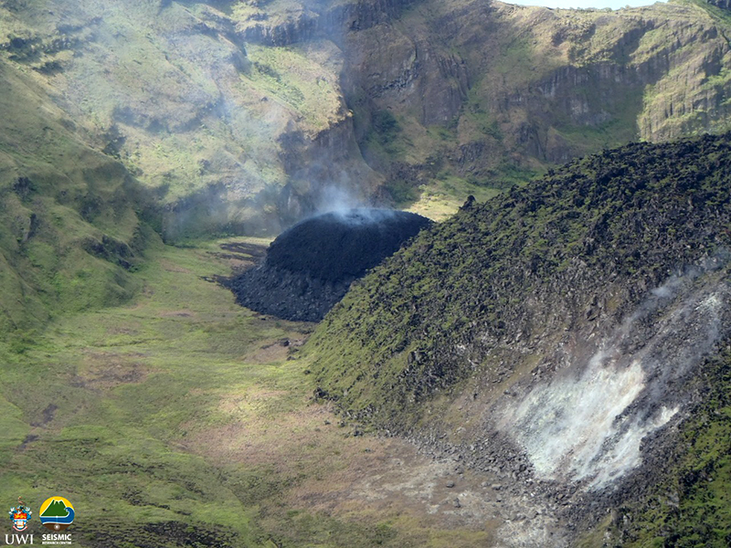 |
Figure 7. Photo of an early observation of the new lava dome at Soufrière St. Vincent on 29 December 2020 growing WSW of the 1979 lava dome on the SW edge of the summit crater, accompanied by gas-and-steam emissions. The dome was estimated to be 60 m high on 30 December. Courtesy of Kemron Alexander (color corrected), SMU, UWI-SRC. |
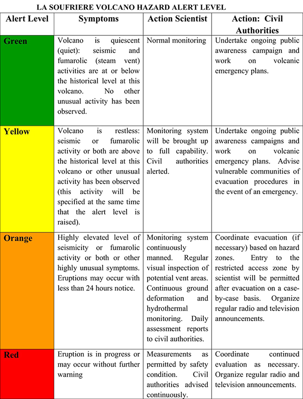 |
Figure 8. Volcanic Hazard Alert Level System for Soufriere St. Vincent. Courtesy of UWI-SRC. |
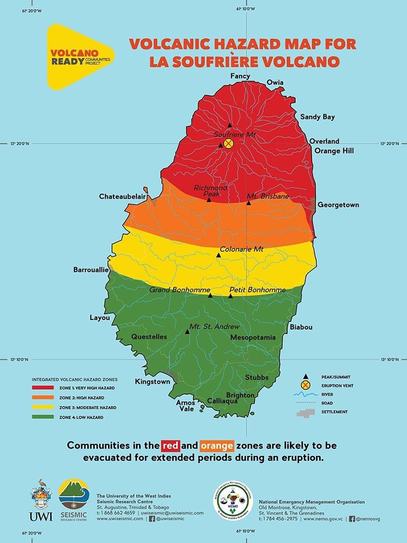 |
Figure 9. Volcanic hazard map for Soufrière St. Vincent, showing different areas that are likely to experience hazardous volcanic events which would require evacuations. The hazard map is divided into four zones: Zone 1 (Red), which is a very high hazard location; Zone 2 (Orange), which is a high hazard location; Zone 3 (Yellow), which is a moderate hazard location; and Zone 4 (Green), which is a low hazard location. This poster was created prior to the current eruption as part of the Volcano Ready Communities Project, a collaboration between NEMO SVG and UWI Seismic Research Centre. Courtesy of UWI-SRC and NEMO. |
Activity during January-February 2021. Observations made during a field visit on 5 January, during a helicopter overflight on 6 January, and based on 9 January drone video noted that the new dome was expanding to the W on the WSW edge of the 1979 lava dome and continued to gradually grow through February 2021 (figure 10). Growth of the 2020/21 lava dome produced small, hot rockfalls and gas-and-steam emissions that were visible from the Belmont Observatory. The gas emissions were most notable from a small depression at the top of the dome. Two seismic stations were installed on the flank of the volcano at Wallibou (SVV) and at the summit (SSVA) on 6 and 18 January, respectively.
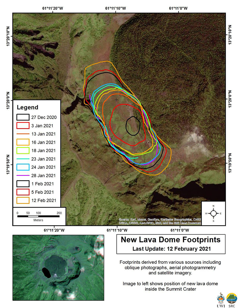 |
Figure 10. Map showing the growth of the new 2020/21 lava dome at Soufrière St. Vincent from 27 December 2020 to 12 February 2021. The dome is located on the SW edge of the crater rim and WSW of the 1979 lava dome that is covered in vegetation. Courtesy of UWI-SRC. |
Seismic stations recorded 573 events through 0730 on 30 January; this number continued to grow into February (up to 703 events by 0830 on 4 February) (figure 5). Observations on 14 January showed that the dome was growing taller and expanding to the E and W. An overflight on 15 January showed extensive vegetation damage on the E, S, and W inner crater walls; damage previously noted on the upper SW crater rim had expanded downslope (figure 11). Scientists visited on 16 January and recorded temperatures of 590°C at the dome surface (figure 12). During 15-17 January residents to the W of the volcano reported nighttime crater incandescence. Persistent gas-and-steam emissions were observed rising above the dome, as well as from the contact between the 2020/21 and 1979 domes during the rest of the month and through February.
 |
Figure 11. Oblique aerial view of the lava dome at Soufrière St. Vincent between the 1979 dome and the SW crater rim on 15 January 2021, accompanied by gas-and-steam emissions. On this day, the dome was 340 m long, 160 m wide, and 80 m high. Courtesy of Adam Stinton, MVO, UWI-SRC. |
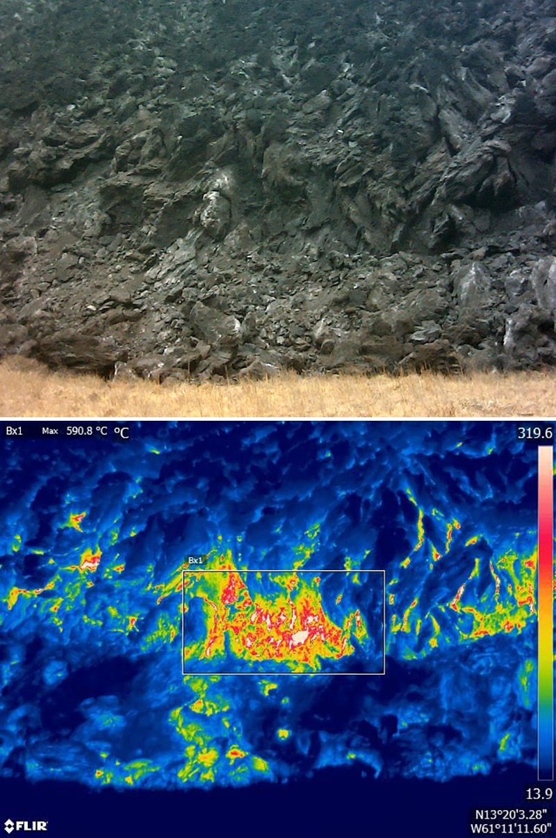 |
Figure 12. Thermal measurements were taken at the base of the freshly extruded lava dome at Soufrière St. Vincent on 16 January 2021. Top: Photo (color corrected) of the base of the new lava dome. Bottom: Thermal FLIR (Forward-Looking InfraRed) image of the base of the new lava dome showing a maximum temperature of 590.8°C. Courtesy of Adam Stinton, MVO, UWI-SRC. |
Sulfur dioxide emissions were first detected on 1 February using a Multi-Gas Instrument and a filter pack; the dome had reached an estimated volume of 5.93 million cubic meters. Vegetation on the NW part of the crater (N of the dome) was damaged, likely due to fire. The dome continued to expand laterally to the N and S, according to reports issued on 6 and 8 February. After that it grew about 15 m to the NW and SE, according to 11 and 15 February reports (figure 13). NEMO reported that the growth rate of the lava dome ranged from 1.9 to 2.13 m3/s (figure 14). Active gas-and-steam emissions originated dominantly at contact areas between the pre-existing 1979 dome and the 2020/21 dome, as well as at the top of the new dome.
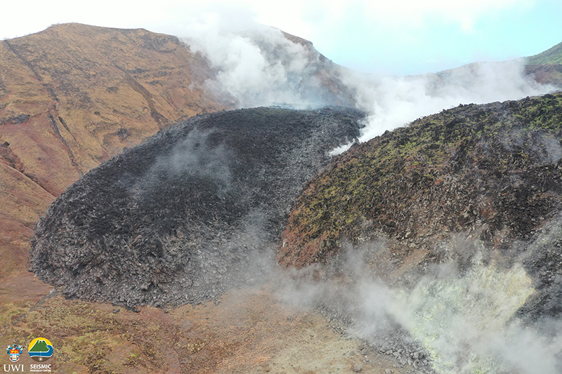 |
Figure 13. Photo of the 2020/21 lava dome (dark mass at left) at Soufrière St. Vincent on 12 February 2021 showing continuous gas-and-steam emissions and damaged vegetation on the 1979 lava dome (right). On this day, the dome was 618 m long, 232 m wide, 90 m high, and an estimated volume of 6.83 million cubic meters. Courtesy of Kemron Alexander, SMU, UWI-SRC. |
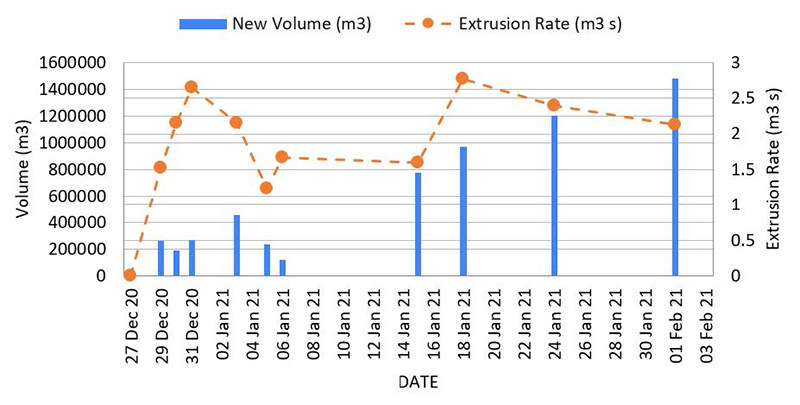 |
Figure 14. Estimated lava extrusion rates and added volume of material at Soufrière St. Vincent’s 2020/21 lava dome during 27 December 2020 through 3 February 2021. Calculations were based on UAV photography and photogrammetry. Data courtesy of UWI-SRC. |
Thermal satellite data. MIROVA (Middle InfraRed Observation of Volcanic Activity) analysis of MODIS satellite data shows the beginning of thermal activity in late December 2020 and continuing at a lower power into early February (figure 15). A single MODVOLC thermal alert was detected on 29 December. This activity marks the beginning of the effusive eruption and the formation of the new lava dome. Sentinel-2 thermal satellite imagery detected a thermal anomaly on the SW side of the main crater during clear weather days in January 2021, which represents the active 2020/21 lava dome (figure 16). Fresh, hot material is also visible surrounding the thermal anomaly, which demonstrates the growth of the lava dome over time.
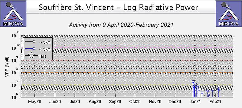 |
Figure 15. Thermal activity at Soufrière St. Vincent was detected beginning in late December 2020 and continued through early February 2021, as reflected in the MIROVA data (Log Radiative Power). The power of the thermal anomalies had slightly decreased after December. Courtesy of MIROVA. |
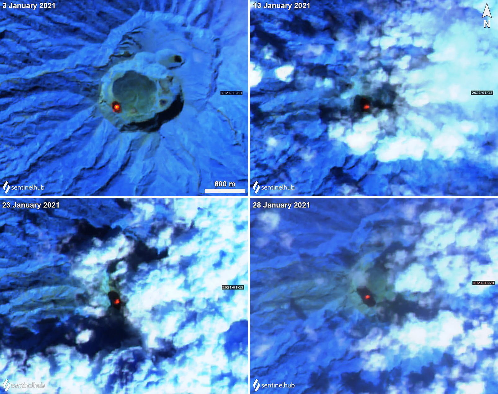 |
Figure 16. Sentinel-2 thermal satellite imagery showing a persistent thermal anomaly (bright yellow-orange) in Soufrière St. Vincent’s growing lava dome on the WSW edge of the main crater during 3 January through 28 January 2021. The dark black color is the freshly cooled material from the effusive activity, which also demonstrates the increasing size of the lava dome. Images using “Atmospheric penetration” rendering (bands 12, 11, 8a). Courtesy of Sentinel Hub Playground. |
Field work during mid-January 2021. SRC collected rock samples from the new lava dome and sent them to scientists from the University of East Anglia, University of Plymouth, and University of Oxford on 16 January 2021 as a collaborative project to analyze their composition and compare them with the composition of rocks erupted in 1902, 1971, and 1979. Analyses showed that the new 2020/21 lava dome was basaltic andesite, similar in composition to the earlier domes (figure 17).
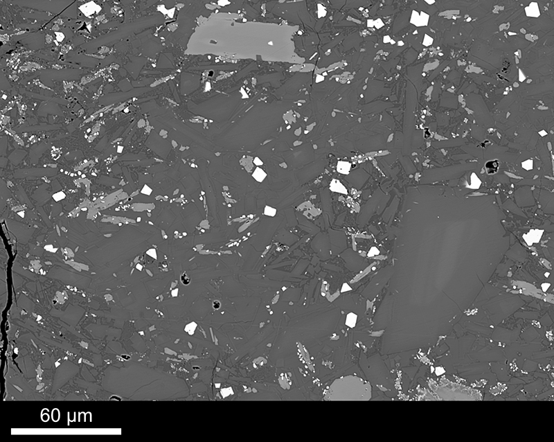 |
Figure 17. Backscattered electron image of a sample from the 2020/21 lava dome showing groundmass texture. Low-contrast dark gray crystals are feldspar microlites in glass (darkest gray). Some of the larger feldspar crystals have Ca-rich cores (paler gray). Clinopyroxenes also make up the groundmass (brighter gray) and some are breaking down to Fe-oxides (small oxides at edges of clinopyroxene bottom center and bottom right). In some areas dark glass is devitrifying (paler gray irregular shapes within dark gray glassy patches). Fe-Ti oxides are also common (bright white crystals). Total image width is about 0.3 mm. Image and description courtesy of Bridie Davies, UEA. |
References: Cole P D, Robertson R E A, Fedele L, Scarpati C, 2019. Explosive activity of the last 1000 years at La Soufrière, St Vincent, Lesser Antilles. J. Volcanol. Geotherm. Res., 371:86-100.
Shepherd, J. B., Aspinall, W. P., Rowley, K. C., Pereira, J., Sigurdsson, H., Fiske, R. S., Tomblin, J. F., 1979. The eruption of Soufrière volcano, St Vincent April–June 1979. Nature, 282 (5734), 24–28. doi:10.1038/282024a0.
Geological Summary. Soufrière St. Vincent is the northernmost and youngest volcano on St. Vincent Island. The NE rim of the 1.6-km wide summit crater is cut by a crater formed in 1812. The crater itself lies on the SW margin of a larger 2.2-km-wide caldera, which is breached widely to the SW as a result of slope failure. Frequent explosive eruptions after about 4,300 years ago produced pyroclastic deposits of the Yellow Tephra Formation, which cover much of the island. The first historical eruption took place in 1718; it and the 1812 eruption produced major explosions. Much of the northern end of the island was devastated by a major eruption in 1902 that coincided with the catastrophic Mont Pelée eruption on Martinique. A lava dome was emplaced in the summit crater in 1971 during a strictly effusive eruption, forming an island within a lake that filled the crater. A series of explosive eruptions in 1979 destroyed the 1971 dome and ejected the lake; a new dome was then built.
Information Contacts: University of the West Indies Seismic Research Centre (UWI-SRC), University of the West Indies, St. Augustine, Trinidad & Tobago, West Indies (URL: http://www.uwiseismic.com/); National Emergency Management Organisation (NEMO), Government of Saint Vincent and the Grenadines, Biseé, PO. Box 1517, Castries, Saint Lucia, West Indies (URL: http://nemo.gov.lc/); MIROVA (Middle InfraRed Observation of Volcanic Activity), a collaborative project between the Universities of Turin and Florence (Italy) supported by the Centre for Volcanic Risk of the Italian Civil Protection Department (URL: http://www.mirovaweb.it/); Hawai'i Institute of Geophysics and Planetology (HIGP) - MODVOLC Thermal Alerts System, School of Ocean and Earth Science and Technology (SOEST), Univ. of Hawai'i, 2525 Correa Road, Honolulu, HI 96822, USA (URL: http://modis.higp.hawaii.edu/); Sentinel Hub Playground (URL: https://www.sentinel-hub.com/explore/sentinel-playground); Google Earth (URL: https://www.google.com/earth/); Bridie Davies, University of East Anglia, Norwich Research Park, Norwich, Norfolk, NR4 7TJ, UK (URL: https://people.uea.ac.uk/bridie_davies).