Report on Piton de la Fournaise (France) — April 2021

Bulletin of the Global Volcanism Network, vol. 46, no. 1 (April 2021)
Managing Editor: Edward Venzke.
Edited by Kadie L. Bennis.
Piton de la Fournaise (France) New eruption with lava fountains and flows on 7-8 December 2020
Please cite this report as:
Global Volcanism Program, 2021. Report on Piton de la Fournaise (France) (Bennis, K.L., and Venzke, E., eds.). Bulletin of the Global Volcanism Network, 46:1. Smithsonian Institution. https://doi.org/10.5479/si.GVP.BGVN202104-233020
Piton de la Fournaise
France
21.244°S, 55.708°E; summit elev. 2632 m
All times are local (unless otherwise noted)
Piton de la Fournaise is located on the French island of Réunion in the western Indian Ocean. Its previous most recent eruption occurred during February into April 2020, characterized by fissure eruptions, fountaining, and significant lava flows (BGVN 45:05). This report covers May through December 2020, describing the new eruption in early December that was characterized by lava fountains and flows, using information from the Observatoire Volcanologique du Piton de la Fournaise (OVPF) and various satellite data.
Slight deformation was recorded after the end of the April eruption, but overall activity during May-November 2020 was low, with no eruptive events, according to OVPF. Starting around 16 June seismicity resumed, which included 77 shallow volcano-tectonic earthquakes during the month and occasional rockfall events in the Dolomieu Crater. This increase in seismicity was accompanied by inflation at the base and summit of the volcano. Shallow volcano-tectonic earthquakes continued to be reported under the Dolomieu Crater during July-November accompanied by rockfall events. In late September the number of shallow volcano-tectonic earthquakes increased markedly to 1,648, but then decreased to 129 in October and only four in November.
OVPF reported that during 0510-0554 on 4 December a seismic swarm of about 101 volcano-tectonic earthquakes was accompanied by minor, but rapid, inflation just below the center and N rim of the Dolomieu Crater. Seismicity decreased after 0600, but inflation continued through 6 December. A second seismic crisis began at 0228 on 7 December, accompanied by rapid inflation. Fissures opened on the WSW flank of the Dolomieu Crater at 0440 at elevations ranging from 2.2-2.3 km and spanning a 700-m-long area; lava began to erupt from these fissures during 0455-0500 (figure 202). Scientists on an overflight at 0700-0730 observed lava fountains rising 15 m high from the three active fissures and short lava flows (figure 203). By 1700 the fissure at an elevation of 2.3 km was the most active, with five small vents, while the other two were showing less intense activity. Satellite data via the HOTVOLC platform showed a lava flow rate of 5 and 30 m3/s during 7 December. The eruption period ended at 0715 on 8 December, following a gradual decrease in tremor and a three-hour phase of seismic signals that indicated degassing. Twenty-one volcano-tectonic earthquakes were recorded during that day under the W rim of the Dolomieu Crater. Another six earthquakes were reported during the morning of 9 December through 0900. Surficial activity was no longer visible.
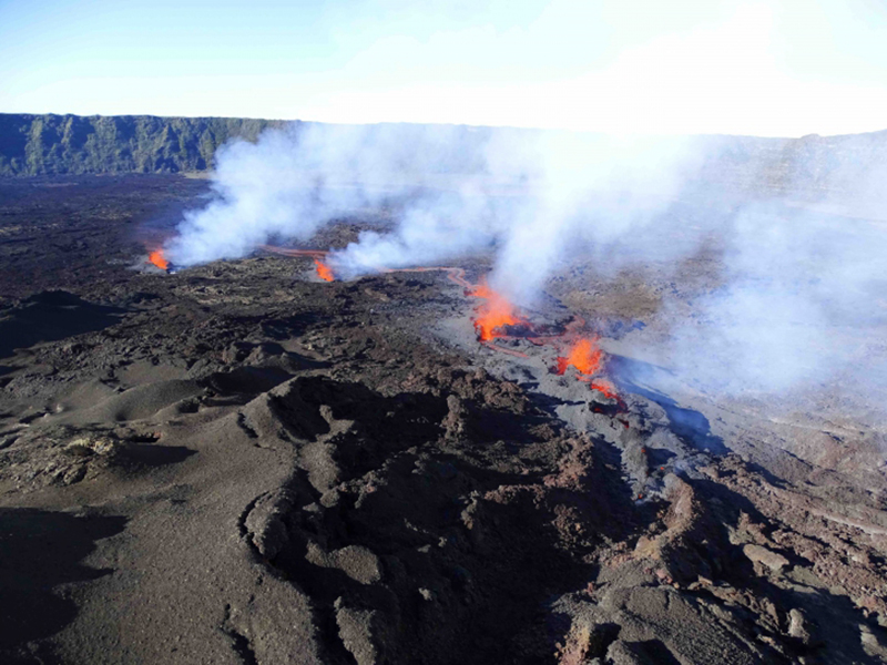 |
Figure 202. Photo of the active fissure vents on the WSW flank of the Dolomieu Crater and the lava fountains accompanied by degassing at Piton de la Fournaise at 0730 on 7 December 2020. Courtesy of OVPF-IPGP (Bulletin d'activité du lundi 7 décembre 2020). |
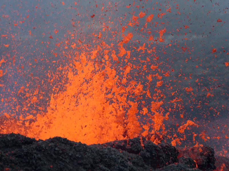 |
Figure 203. Photo of the lava fountains up to 15 m high at Piton de la Fournaise during 7-8 December 2020. Courtesy of OVPF-IPGP. |
MIROVA (Middle InfraRed Observation of Volcanic Activity) analysis of MODIS satellite data showed brief, but significant, thermal activity during early December, reflecting the new eruption. This thermal activity was also visible in Sentinel-2 thermal satellite imagery on 7 December 2020, showing lava flows and possibly lava fountains from the fissures on the SW and W flanks (figure 204). Accompanying this activity were SO2 emissions that were detected by the Sentinel-5P/TROPOMI instrument (figure 205).
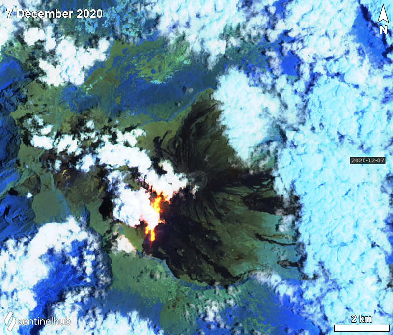 |
Figure 204. Sentinel-2 infrared satellite image of the thermal activity (bright yellow-orange) on the S and SW flanks of Piton de la Fournaise on 7 December 2020. Sentinel-2 satellite images with “Atmospheric penetration” (bands 12, 11, 8A) rendering. Courtesy of Sentinel Hub Playground. |
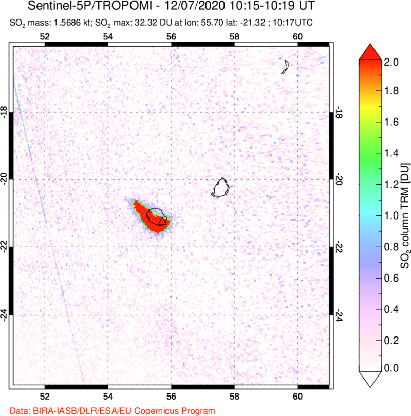 |
Figure 205. Image of the SO2 emissions that occurred during the eruption at Piton de la Fournaise on 7 December 2020 detected by the Sentinel-5P/TROPOMI satellite. Courtesy of NASA Global Sulfur Dioxide Monitoring Page. |
Geological Summary. Piton de la Fournaise is a massive basaltic shield volcano on the French island of Réunion in the western Indian Ocean. Much of its more than 530,000-year history overlapped with eruptions of the deeply dissected Piton des Neiges shield volcano to the NW. Three scarps formed at about 250,000, 65,000, and less than 5,000 years ago by progressive eastward slumping, leaving caldera-sized embayments open to the E and SE. Numerous pyroclastic cones are present on the floor of the scarps and their outer flanks. Most recorded eruptions have originated from the summit and flanks of Dolomieu, a 400-m-high lava shield that has grown within the youngest scarp, which is about 9 km wide and about 13 km from the western wall to the ocean on the E side. More than 150 eruptions, most of which have produced fluid basaltic lava flows, have occurred since the 17th century. Only six eruptions, in 1708, 1774, 1776, 1800, 1977, and 1986, have originated from fissures outside the scarps.
Information Contacts: Observatoire Volcanologique du Piton de la Fournaise, Institut de Physique du Globe de Paris, 14 route nationale 3, 27 ème km, 97418 La Plaine des Cafres, La Réunion, France (URL: http://www.ipgp.fr/fr); NASA Global Sulfur Dioxide Monitoring Page, Atmospheric Chemistry and Dynamics Laboratory, NASA Goddard Space Flight Center (NASA/GSFC), 8800 Greenbelt Road, Goddard, Maryland, USA (URL: https://so2.gsfc.nasa.gov/); MIROVA (Middle InfraRed Observation of Volcanic Activity), a collaborative project between the Universities of Turin and Florence (Italy) supported by the Centre for Volcanic Risk of the Italian Civil Protection Department (URL: http://www.mirovaweb.it/); Sentinel Hub Playground (URL: https://www.sentinel-hub.com/explore/sentinel-playground).