Report on Manam (Papua New Guinea) — April 2021

Bulletin of the Global Volcanism Network, vol. 46, no. 4 (April 2021)
Managing Editor: Edward Venzke.
Edited by Kadie L. Bennis.
Manam (Papua New Guinea) Ash plumes, SO2 plumes, and thermal anomalies continued during October 2020-March 2021
Please cite this report as:
Global Volcanism Program, 2021. Report on Manam (Papua New Guinea) (Bennis, K.L., and Venzke, E., eds.). Bulletin of the Global Volcanism Network, 46:4. Smithsonian Institution. https://doi.org/10.5479/si.GVP.BGVN202104-251020
Manam
Papua New Guinea
4.08°S, 145.037°E; summit elev. 1807 m
All times are local (unless otherwise noted)
Manam is located 13 km off the N coast of mainland Papua New Guinea and has had eruptions documented since 1616. It contains two active summit craters, Main and South, which have been characterized by occasional Strombolian activity, lava flows, pyroclastic avalanches, and ash plumes. The current eruption period has been ongoing since 2014 with more recent activity consisting of intermittent ash plumes, thermal anomalies, and sulfur dioxide emissions (BGVN 45:10). This report describes similar activity and covers October 2020 through March 2021 using information primarily from the Darwin Volcanic Ash Advisory Center (VAAC) and various satellite data.
Explosive and thermal activity was relatively low during this reporting period. Three ash plumes were reported by the Darwin VAAC based on imagery from the HIMIWARI-8 satellite. On 6 December 2020 an ash plume rose to 2.4 km altitude and drifted SW. The next VAAC notice was for ash detected on 23 January 2021 rising to 4.9 km and drifting SE and N. Then on 21 February an ash plume rose to a maximum altitude of 6 km and drifted W. Intermittent sulfur dioxide plumes were detected using the TROPOMI instrument on the Sentinel-5P satellite, some of which reached at least two Dobson Units (DU) and drifted in multiple directions (figure 79). On 6 December and 23 January, the ash plume that was described in the Darwin VAAC advisory was accompanied by an SO2 plume. SO2 plumes that reached a minimum of two DU were recorded for at least 12 days during October, 13 days during November, 15 days during December, 10 days during January, 3 days during February, and 6 days during March.
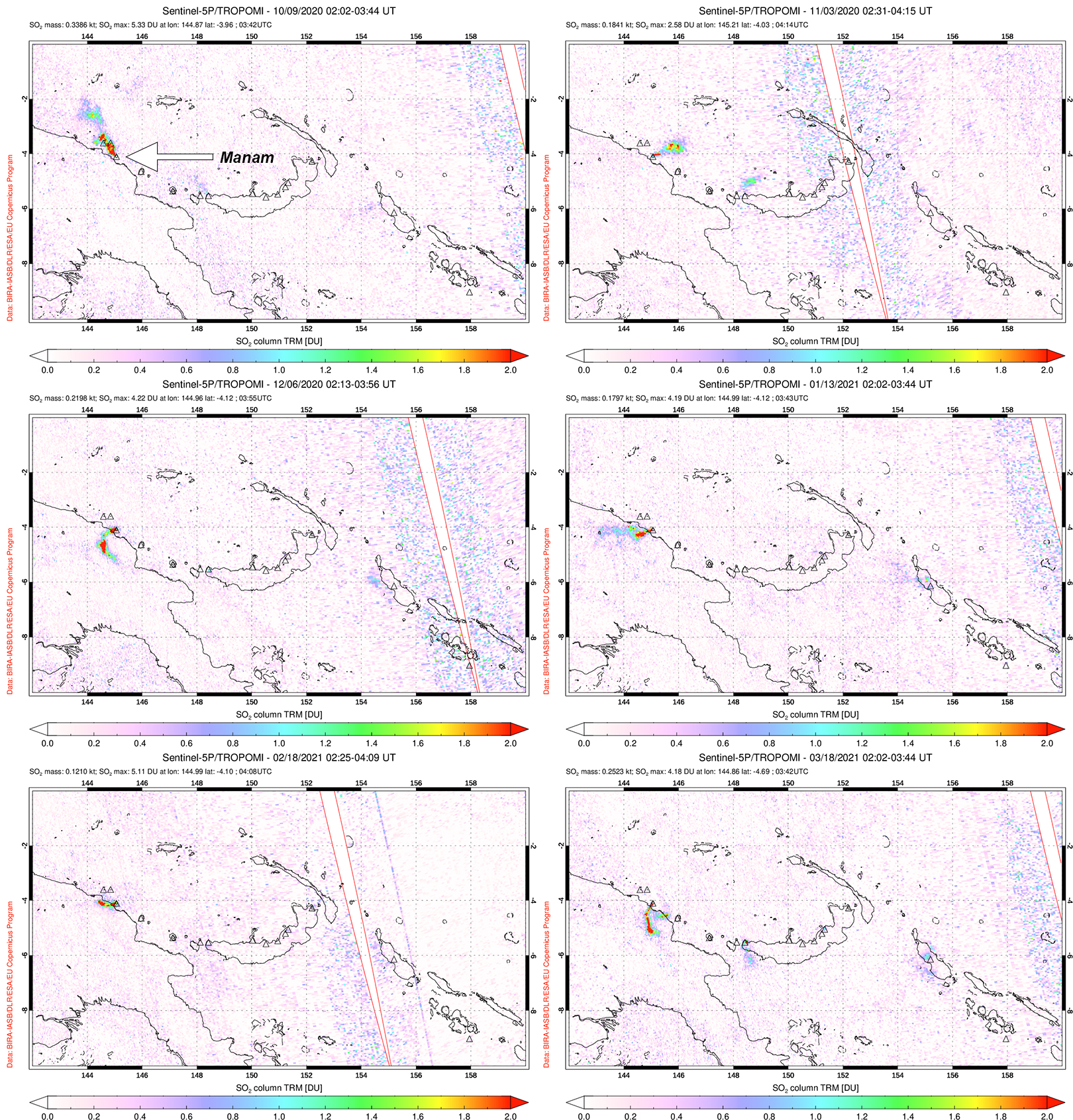 |
Figure 79. Distinct sulfur dioxide plumes rising from Manam and drifting in different directions were detected using data from the TROPOMI instrument on the Sentinel-5P satellite on 9 October (top left), 3 November (top right), 6 December (middle left) 2020, 13 January (middle right), 18 February (bottom left), and 18 March (bottom right) 2021. Courtesy of the NASA Global Sulfur Dioxide Monitoring Page. |
Thermal activity during October 2020 through March 2021 was relatively low in power and frequency compared to August and September, as recorded by the MIROVA (Middle InfraRed Observation of Volcanic Activity) system. Two brief pulses of activity were detected during mid-November and late December to mid-January (figure 80). A total of 14 low-power anomalies were recorded: one in early October, three in mid-November, two in December, a maximum number of six in January, one in late February, and one in late March. Some of this activity was captured in Sentinel-2 thermal satellite imagery on clear weather days in both the Main and South summit craters (figure 81).
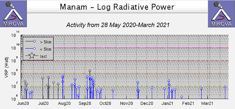 |
Figure 80. Thermal activity at Manam was low to moderate in power during October 2020 through March 2021, with notable brief pulses during mid-November and late December through mid-January, as shown on this MIROVA Log Radiative Power graph. One anomaly was detected in early October, three in mid-November, two in December, six in January, one in late February, and one in late March. Courtesy of MIROVA. |
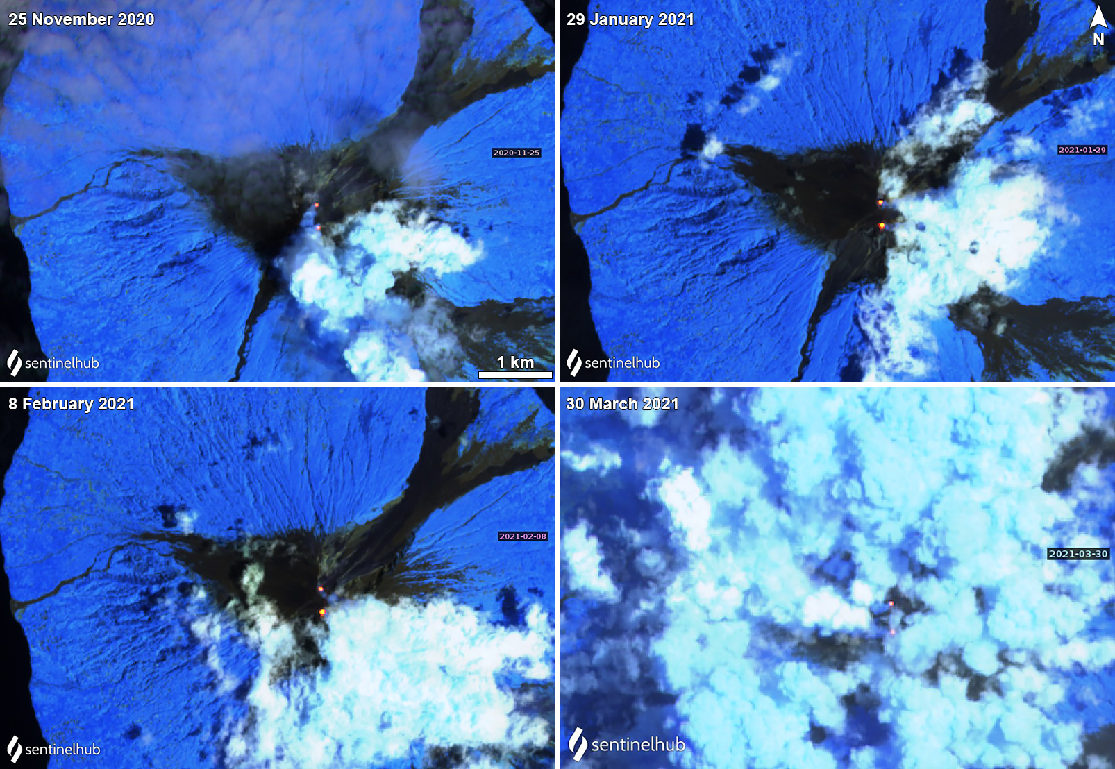 |
Figure 81. Sentinel-2 thermal satellite images show a persistent thermal anomaly (bright yellow-orange) at both of Manam’s summit craters (Main and South) on clear weather days during November 2020 through March 2021. Occasional gas-and-steam emissions accompanied the thermal anomalies as seen on 25 November 2020 (top left), 29 January (top right), 8 February (bottom left), and 20 March (bottom right) 2021. Sentinel-2 satellite images with “Atmospheric penetration” (bands 12, 11, 8A) rendering. Courtesy of Sentinel Hub Playground. |
Geological Summary. The 10-km-wide island of Manam, lying 13 km off the northern coast of mainland Papua New Guinea, is one of the country's most active volcanoes. Four large radial valleys extend from the unvegetated summit of the conical basaltic-andesitic stratovolcano to its lower flanks. These valleys channel lava flows and pyroclastic avalanches that have sometimes reached the coast. Five small satellitic centers are located near the island's shoreline on the northern, southern, and western sides. Two summit craters are present; both are active, although most observed eruptions have originated from the southern crater, concentrating eruptive products during much of the past century into the SE valley. Frequent eruptions, typically of mild-to-moderate scale, have been recorded since 1616. Occasional larger eruptions have produced pyroclastic flows and lava flows that reached flat-lying coastal areas and entered the sea, sometimes impacting populated areas.
Information Contacts: Darwin Volcanic Ash Advisory Centre (VAAC), Bureau of Meteorology, Northern Territory Regional Office, PO Box 40050, Casuarina, NT 0811, Australia (URL: http://www.bom.gov.au/info/vaac/); MIROVA (Middle InfraRed Observation of Volcanic Activity), a collaborative project between the Universities of Turin and Florence (Italy) supported by the Centre for Volcanic Risk of the Italian Civil Protection Department (URL: http://www.mirovaweb.it/); NASA Global Sulfur Dioxide Monitoring Page, Atmospheric Chemistry and Dynamics Laboratory, NASA Goddard Space Flight Center (NASA/GSFC), 8800 Greenbelt Road, Goddard, Maryland, USA (URL: https://so2.gsfc.nasa.gov/); Sentinel Hub Playground (URL: https://www.sentinel-hub.com/explore/sentinel-playground).