Report on Fuego (Guatemala) — April 2021

Bulletin of the Global Volcanism Network, vol. 46, no. 4 (April 2021)
Managing Editor: Edward Venzke.
Edited by A. Elizabeth Crafford.
Fuego (Guatemala) Ash plumes, ashfall, and incandescent block avalanches through March 2021; lava flows and a pyroclastic flow in mid-February
Please cite this report as:
Global Volcanism Program, 2021. Report on Fuego (Guatemala) (Crafford, A.E., and Venzke, E., eds.). Bulletin of the Global Volcanism Network, 46:4. Smithsonian Institution. https://doi.org/10.5479/si.GVP.BGVN202104-342090
Fuego
Guatemala
14.4748°N, 90.8806°W; summit elev. 3799 m
All times are local (unless otherwise noted)
Guatemala's Volcán de Fuego has been erupting vigorously since 2002; reported eruptions date back to 1531. These eruptions have resulted in major ashfalls, pyroclastic flows, lava flows, and damaging lahars, including a series of explosions and pyroclastic flows in early June 2018 that caused several hundred fatalities. Activity consisting of explosions with ash emissions, block avalanches, and lava flows has continued since 2018; activity during December 2020-March 2021 is covered in this report. Daily reports are provided by the Instituto Nacional de Sismologia, Vulcanología, Meteorología e Hidrologia (INSIVUMEH); aviation alerts of ash plumes are issued by the Washington Volcanic Ash Advisory Center (VAAC). Satellite data provide valuable information about thermal anomalies and ash emissions.
The many hourly explosions at Fuego throughout December 2020-March 2021 produced vibrations that rattled roofs and windows in the communities around the volcano every day, sometimes heard and felt as far as 20 km away. The explosions produced incandescent block avalanches that descended the flank ravines (barrancas), with a few of the blocks traveling as far as the vegetation near the bottom. The Seca, Ceniza, and Taniluya ravines were most often affected, but blocks were also reported many times in the Trinidad, Santa Teresa, El Jute, Las Lajas, and Honda ravines. Incandescent ejecta could be seen rising 100-300 m above the summit on most nights. Ash plumes rose to 4.4-4.8 km altitude every day and usually drifted W and SW; the Washington VAAC issued 2-5 ash advisories daily. Ashfall was a near-daily occurrence throughout the period. Effusive activity from 13-15 February produced two lava flows; a series of pyroclastic flows on 14 February affected the Ceniza canyon. For several days after the effusive activity, strong explosions caused ashfall in communities up to 50 km away. The MIROVA graph of thermal anomalies showed persistent high heat levels throughout the period with a brief spike to higher levels during mid-February when the lava flows were active (figure 141). MODVOLC thermal alerts were issued on multiple days each month including eight days in December 2020, 11 days in January 2021, 12 days in February, and seven days in March. Sentinel-2 satellite data showed thermal anomalies inside the summit crater five or six times each month, in all available non-cloudy images.
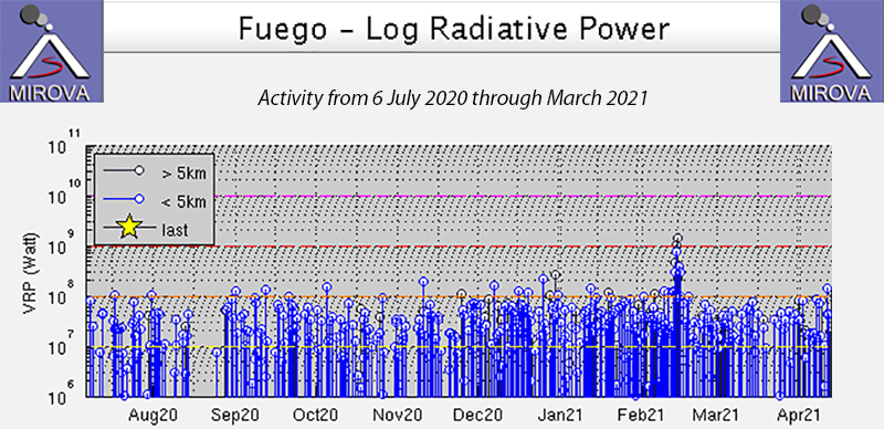 |
Figure 141. Consistently high levels of thermal anomalies continued at Fuego during July 2020-March 2021. A brief spike in mid-February 2021 corresponded to two lava flows and a pyroclastic flow. Courtesy of MIROVA. |
Explosive activity continued at Fuego during December 2020. Seven to eleven explosions per hour were typical; a few days had 10-15 explosions per hour. Gas and ash emissions rose to 4.4-4.8 km every day with ash plumes drifting usually W and SW 10-15 km, occasionally to 20-25 km (figure 142). Plumes drifted over 10 km N and NE on 6 December, 20-25 km S and SW on 13 and 14 December, and 30 km E, SE, and N during 28-31 December. Vibrations were heard and felt up to 15 km away on the W and SW flanks on 7 December. Ashfall was reported almost daily in multiple communities including Panimache I and II, Morelia, Santa Sofia, Los Yucales, Sangre de Cristo, Finca Palo Verde, and San Pedro Yepocapa. In addition, ashfall was reported on 10 December in Ojo de Agua and Santa Isabel, on 14 Dec in Ojo de Agua and Santa Emilia, in Santa Emilia on 20 and 21 December, and in Chimaltenango to the N on 31 December.
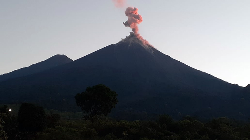 |
Figure 142. An ash plume rose from the summit of Fuego early on 9 December 2020 while blocks descended multiple ravines and resuspended ash on the flanks. Photo by Fredy Arnoldo Esquit Chiquitá, 07:56 am hora local, courtesy of INSIVUMEH. |
The ash plume drift direction continued to be N and NW on 1 and 2 January 2021 resulting in ashfall reported in San Pedro Yepocapa, La Soledad, and San Miguel Duenas. According to INSIVUMEH, plumes drifted 20-25 km those days. In addition to ashfall in Panimache I, Morelia, Santa Sofia, and Yucales most days of the month, ashfall was reported in La Rochela on 3 and 6 January and Ceilan on 6 January. Ashfall was reported to the N in Acatenango on 10 January after activity increased; rumbling was heard 20 km away. Explosions produced ejecta which rose 300 m and sent incandescent blocks around the crater rim and onto the upper flanks. High levels of activity continued the next day and produced ashfall in San Pedro Yepocapa, Santa Sophia, Morelia, Panimache II, El Porvenir Yepocapa, Sangre de Cristo, and at finca Palo Verde. Pulses of incandescent ejecta rising 100-300 m were common during the second half of January and ashfall continued on many days in the same communities to the W and SW. Remobilized ash triggered by incandescent blocks descending the ravines was reported in the last week of January. The number of explosions per hour was 6-12 on many days and they produced noises as loud as a train engine that lasted for several minutes at a time.
Explosive activity during February 2021 remained the same as previous months, with 7-15 explosions per hour, train engine noises that lasted for 3-10 minutes, and gas and ash plumes that rose usually to 4.5-4.8 km altitude and drifted W, SW, and S. Rumblings that rattled windows and roofs were heard 15-20 km away on 5 and 10 February; incandescent blocks descended the ravines for hundreds of meters (figure 143). Near-daily reports of ashfall in communities to the W, SW, and S continued; most affected were Panimache I, Morelia, Santa Sofia, Porvenir, Finca Asuncion, Rochela, Santa Sofia, Yucales, Sangre de Cristo, Palo Verde and Yepocapa. In addition Ceilan, El Zapote, and El Rodeo reported ashfall on 5 February when winds carried ash to S and SE.
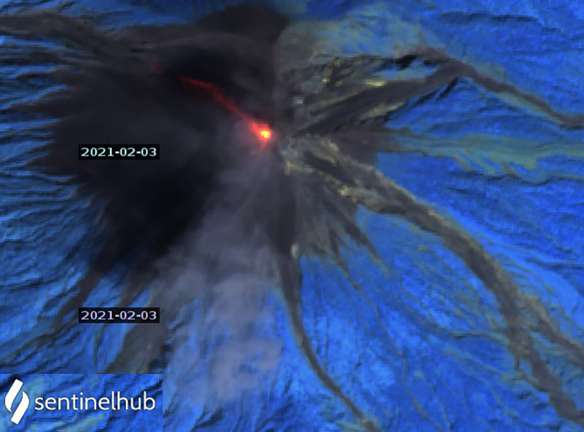 |
Figure 143. Incandescent block avalanches could be seen descending a ravine on the NW flank of Fuego in Sentinel-2 satellite imagery on 3 February 2021. A diffuse ash plume drifts S from the summit. Image uses Atmospheric penetration rendering (bands 12, 11, 8a). Courtesy of Sentinel Hub Playground. |
In a special report issued on 13 February INSIVUMEH noted that the seismic station had registered a change in the eruptive pattern on 12 February. During the night a lava flow emerged from the summit and traveled 1,000 m down the Ceniza ravine on the SW flank (figure 144). It produced incandescent blocks at the leading edge that fell farther, reaching the vegetation. Loud noises similar to a train engine were audible 8 km from the volcano. At 2100 on 13 February a second flow began in the Seca ravine that grew to 500 m long. Incandescent ejecta rose 200 m above the crater and constant loud noises were reported. By this time the Ceniza flow had reached 1,500 m. The following morning both flows remained active; the barranca Ceniza flow was 1,300 m long and the barranca Seca flow was 500 m long. Persistent explosions of ejecta to 200 m above the crater continued along with loud noises. The incandescent blocks spalling off the front of the flows remobilized ash that drifted S, SE, and SW.
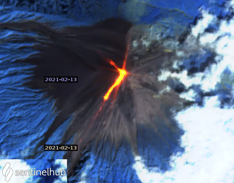 |
Figure 144. Two lava flows were active on the flanks of Fuego on 13 February 2021. A flow in the Ceniza ravine on the SW flank grew to 1,500 m long, while a 500-m-long flow descended the Seca ravine on the NW flank. Sentinel-2 image uses Atmospheric penetration rendering (bands 12, 11, 8a). Courtesy of Sentinel Hub Playground. |
Beginning at 1020 on 14 February 2021 a series of pyroclastic flows were observed in the Ceniza ravine. They lasted for three minutes and traveled several hundred meters. Ashfall was reported in Alotenango, El Porvenir, and Finca La Reunion. By the end of the day the Ceniza lava flow was active for 800 m and the Seca flow reached 200 m. Seismic energy decreased noticeably the next day along with a decrease in the flow rate and thermal energy. Explosions continued with ash plumes drifting E, NE, and N up to 50 km resulting in ashfall in Porvenir and Alotenango. INSIVUMEH considered the effusive eruption over by the evening of 15 February, and noted a decrease in the rate of explosions to 12-14 per hour (figure 145).
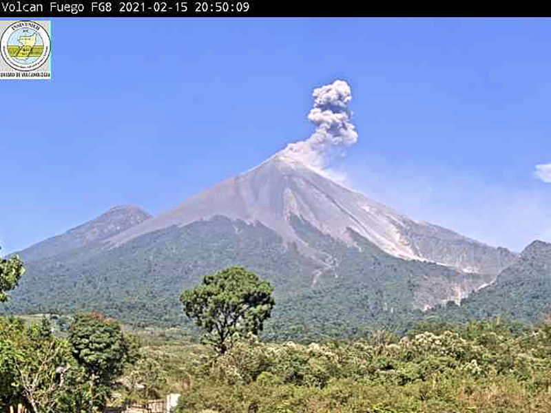 |
Figure 145. Although explosions at Fuego on 15 February 2021 had decreased in frequency, they still produced ash plumes and blocks rolling down the ravines that caused plumes of resuspended ash. Courtesy of INSIVUMEH (BOLETIN VULCANOLOGICO ESPECIAL BEFGO 023-2021, Guatemala, 15 de febrero de 2021, 15:30 horas). |
Loud explosions continued 16 February and produced abundant ash that drifted E, NE, and N. The Washington VAAC reported intermittent ash emissions seen in satellite images moving ESE at 4.9 km altitude extending around 110 km from the summit before dissipating. Ashfall was reported in Celian, San Andres Ozuna, Rochela, Zapote, and El Rodeo. On 17 February ash plumes rose to 4.5-4.8 km altitude and drifted N, NE, and E as far as 50 km and caused ashfall in many communities, including as far away as Guatemala City. The wind changed to the E and SE later in the day, and plumes drifted 30-40 km over the departments of Sacatepequez, Escuintla, and Guatemala. Ash plumes from Pacaya were also affecting the same areas that day. The following day ash plumes were drifting 40 km SW. For the remainder of February ashfall affected the same communities to the SW and W as earlier in the month. The incandescent ejecta that rose 350 m above the summit on 28 February produced a strong thermal anomaly in satellite data that also showed incandescent blocks descending all the ravines around the summit (figure 146).
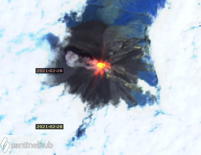 |
Figure 146. Incandescent ejecta was observed 350 m above the summit of Fuego on 28 February 2021 and produced a strong thermal anomaly shown in this Sentinel-2 satellite image. Also visible is incandescent ejecta around all the ravines near the summit and a small ash plume drifting WNW. Image uses Atmospheric penetration rendering (bands 12, 11, 8a). Courtesy of Sentinel Hub Playground. |
Explosive activity continued throughout March 2021, producing ash plumes that rose to 4.5-4.8 km altitude and drifted mostly W and SW (figure 147). This resulted in ashfall most days in the same communities as before that were located 10-20 km away. The loud rumblings continued daily, lasting for 2-5 minutes at a time and rattling windows and roofs all around the volcano. Incandescent ejecta rose 100-300 m and the blocks traveled down all of the ravines, sometimes reaching the vegetation.
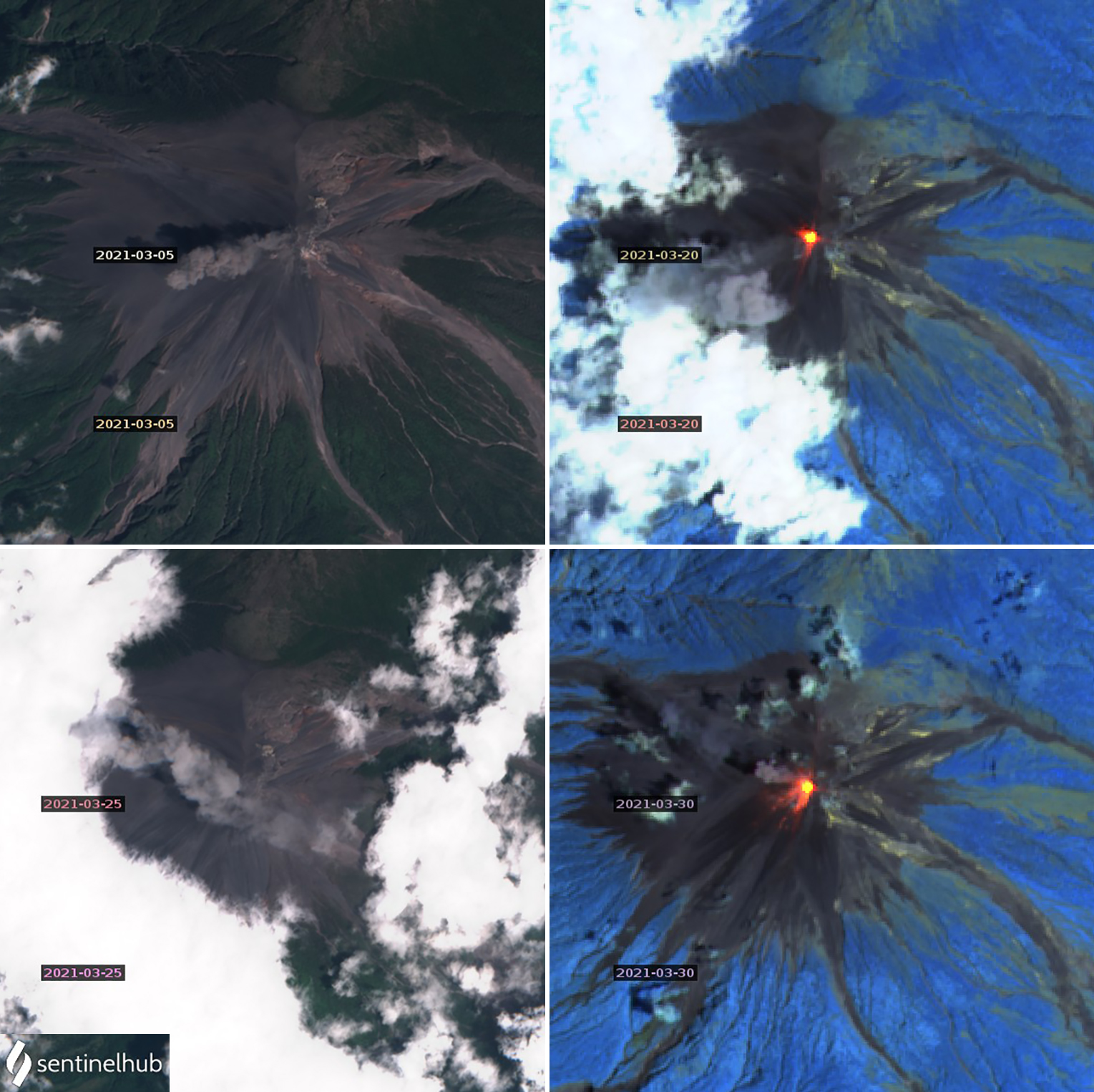 |
Figure 147. Numerous ash emissions at Fuego during March 2021 were captured in Sentinel-2 satellite images along with the frequent thermal anomalies. Ash plumes drifted W on 5 and 20 March (top row) and NW on 25 and 30 March 2021 (bottom row). Images for 5 and 25 March use Natural color rendering (bands 4, 3, 2). Images for 20 and 30 March show Atmospheric penetration rendering (bands 12, 11, 8a). Courtesy of Sentinel Hub Playground. |
Geological Summary. Volcán Fuego, one of Central America's most active volcanoes, is also one of three large stratovolcanoes overlooking Guatemala's former capital, Antigua. The scarp of an older edifice, Meseta, lies between Fuego and Acatenango to the north. Construction of Meseta dates back to about 230,000 years and continued until the late Pleistocene or early Holocene. Collapse of Meseta may have produced the massive Escuintla debris-avalanche deposit, which extends about 50 km onto the Pacific coastal plain. Growth of the modern Fuego volcano followed, continuing the southward migration of volcanism that began at the mostly andesitic Acatenango. Eruptions at Fuego have become more mafic with time, and most historical activity has produced basaltic rocks. Frequent vigorous eruptions have been recorded since the onset of the Spanish era in 1524, and have produced major ashfalls, along with occasional pyroclastic flows and lava flows.
Information Contacts: Instituto Nacional de Sismologia, Vulcanologia, Meteorologia e Hydrologia (INSIVUMEH), Unit of Volcanology, Geologic Department of Investigation and Services, 7a Av. 14-57, Zona 13, Guatemala City, Guatemala (URL: http://www.insivumeh.gob.gt/ ); Washington Volcanic Ash Advisory Center (VAAC), Satellite Analysis Branch (SAB), NOAA/NESDIS OSPO, NOAA Science Center Room 401, 5200 Auth Rd, Camp Springs, MD 20746, USA (URL: www.ospo.noaa.gov/Products/atmosphere/vaac, archive at: http://www.ssd.noaa.gov/VAAC/archive.html); MIROVA (Middle InfraRed Observation of Volcanic Activity), a collaborative project between the Universities of Turin and Florence (Italy) supported by the Centre for Volcanic Risk of the Italian Civil Protection Department (URL: http://www.mirovaweb.it/); Hawai'i Institute of Geophysics and Planetology (HIGP) - MODVOLC Thermal Alerts System, School of Ocean and Earth Science and Technology (SOEST), Univ. of Hawai'i, 2525 Correa Road, Honolulu, HI 96822, USA (URL: http://modis.higp.hawaii.edu/); Sentinel Hub Playground (URL: https://www.sentinel-hub.com/explore/sentinel-playground).