Report on Nyiragongo (DR Congo) — June 2021

Bulletin of the Global Volcanism Network, vol. 46, no. 6 (June 2021)
Managing Editor: Edward Venzke.
Edited by Kadie L. Bennis.
Nyiragongo (DR Congo) Intense seismicity, lava flows into Goma, strong incandescence, and ash plumes during late May 2021
Please cite this report as:
Global Volcanism Program, 2021. Report on Nyiragongo (DR Congo) (Bennis, K.L., and Venzke, E., eds.). Bulletin of the Global Volcanism Network, 46:6. Smithsonian Institution. https://doi.org/10.5479/si.GVP.BGVN202106-223030
Nyiragongo
DR Congo
1.52°S, 29.25°E; summit elev. 3470 m
All times are local (unless otherwise noted)
Nyiragongo, in the Democratic Republic of the Congo, is part of the Virunga Volcanic Province (VVP) along the western branch of the East African Rift System. It contains a 1.2 km-wide summit crater with a lava lake that has been active since at least 1971. Lava flows have been a hazard in the past for the nearby city of Goma (15 km S); the most recent documented lava flows occurred in April 2019 from a secondary cone that had formed in February 2016, accompanied by ejecta (BGVN 44:05). These flows, along with those that were reported during February and March 2016 (BGVN 42:01), were confined to the crater lake. Significant lava flows on the S flank during the 2002 eruption reached the city of Goma and Lake Kivu, destroying several thousands of buildings and homes, damaging agriculture, and displacing more than 250,000 people (BGVN 26:12 and 27:04). Volcanism has more recently and typically consisted of lava lake activity (evidenced by strong thermal anomalies), incandescence, and gas-and-steam emissions (BGVN 45:12). This report covers December 2020 through May 2021 and describes a notable flank fissure eruption characterized by new intense seismicity, lava lake drainage, lava flows reaching Goma, and ash plumes that increased in late May 2021. As a result, more than 400,000 people were evacuated, about 3,600 homes and buildings were destroyed, and at least 32 people died. The volcano is monitored by the Observatoire Volcanologique de Goma (OVG).
Strong thermal activity was consistent at the lava lake during December 2020 through May 2021, according to satellite data. MIROVA (Middle InfraRed Observation of Volcanic Activity) analysis of MODIS satellite data showed frequent and strong thermal anomalies into late May 2021 before significantly decreasing (figure 79). These strong summit anomalies were also observed in Sentinel-2 infrared satellite imagery during each month of the reporting period, though cloud cover was frequent (figure 80).
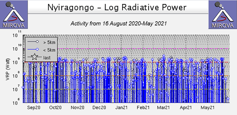 |
Figure 79. Thermal anomalies at Nyiragongo from 16 August 2020 through May 2021 as recorded by the MIROVA system (Log Radiative Power) were frequent and strong. A sharp decrease in thermal activity was noted at the end of May. Courtesy of MIROVA. |
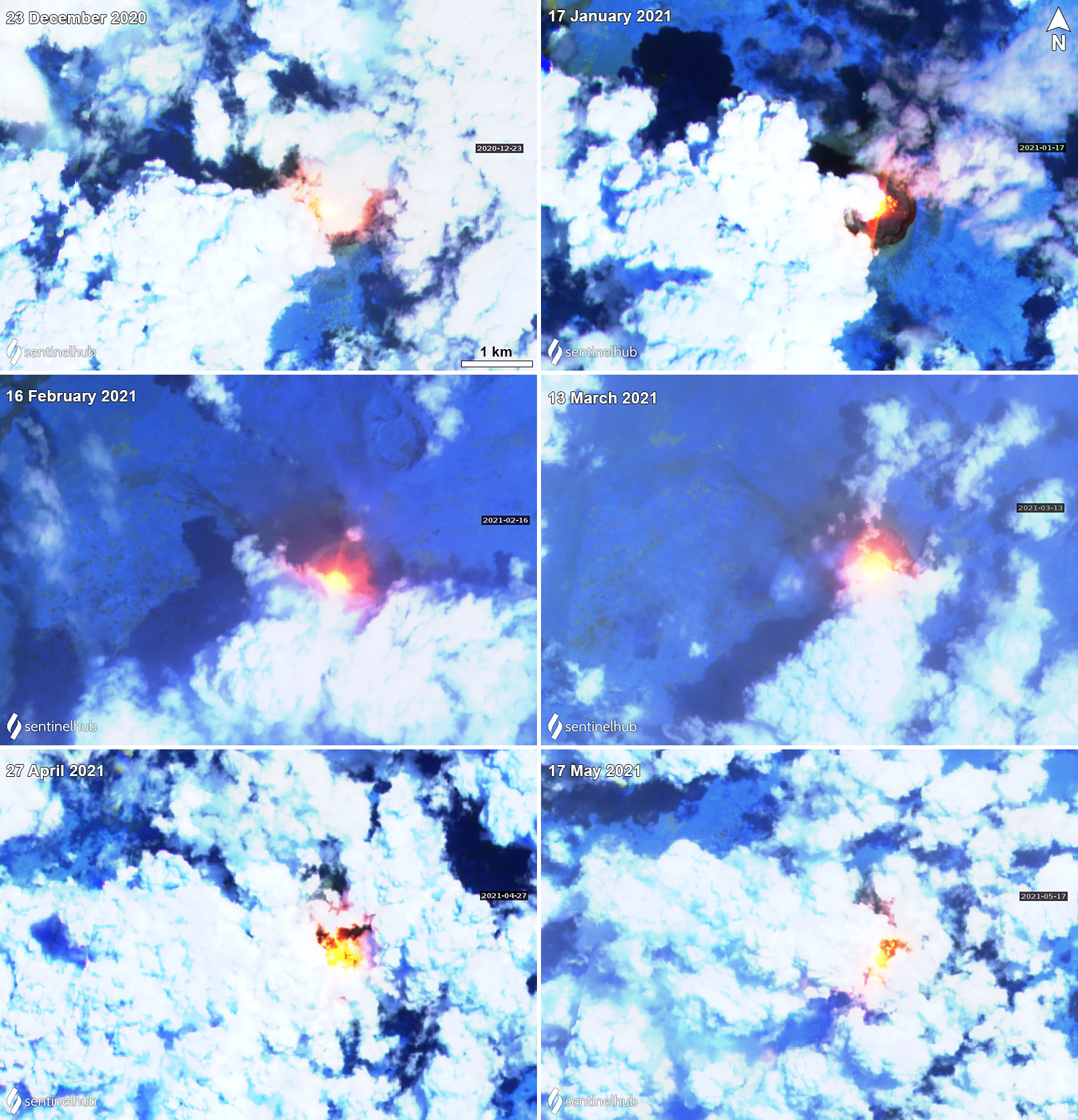 |
Figure 80. Sentinel-2 infrared satellite imagery showed strong thermal anomalies (bright yellow-orange) in the summit crater of Nyiragongo each month during December 2020 through May 2021. Images using “Atmospheric penetration” rendering (bands 12, 11, 8a). Courtesy of Sentinel Hub Playground. |
On the evening of 22 May the active lava lake drained, and around the same time observers reported that at least two fissures had opened on the lower S flanks NW of Kibati (8 km SSE of the summit) and Rukoko (10 km S) (figure 81). Seismicity and infrasound data showed the change in activity with strong increases starting at 1815 that night (figure 82). Lava from the first fissure originated near the Shaheru crater, flowed over a major road (N2), and then moved S. The second fissure produced lava flows that also traveled S, setting fire to many houses and structures in communities N of Goma, just W of Monigi (12 km S). Video posted on social media showed lava fountaining from the fissure and an incandescent red sky (figure 83). During 22-23 May the lava flow may have been as wide as 1 km and stopped 1.25 km from the Goma International Airport in the NE part of the city (figures 83, 84, and 85).
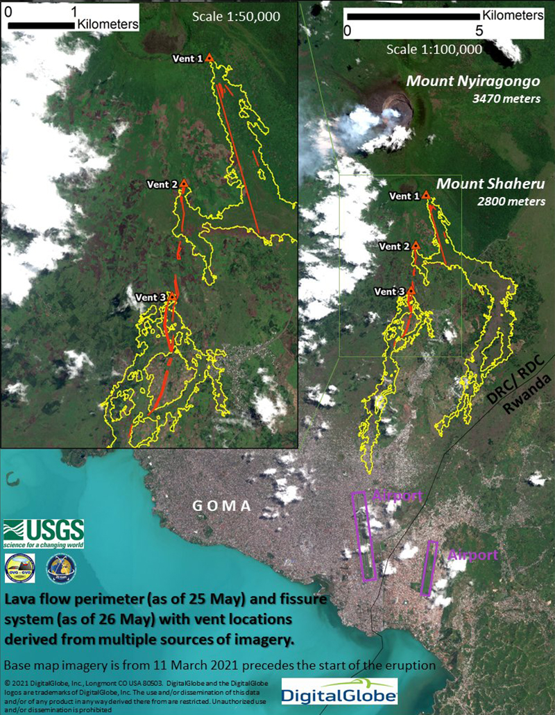 |
Figure 81. Map showing the lava flows (yellow) from the opened fissures (red) at Nyiragongo during 22-26 May 2021. The lava flows had traveled generally S and SE. The two nearby airports are boxed in purple. The base map was last updated on 11 March 2021. Courtesy of VDAP USGS. |
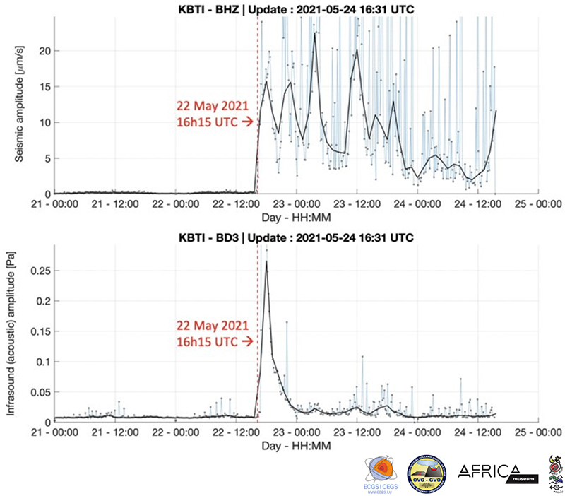 |
Figure 82. Seismic and infrasound amplitude measurements at Nyiragongo recorded during 21-24 May 2021 at the Kibati station (6 km E). A significant spike in seismic and infrasound amplitude occurred on 22 May 2021 at 1815 local time, indicating the start of new activity. Courtesy of GeoRiskA. |
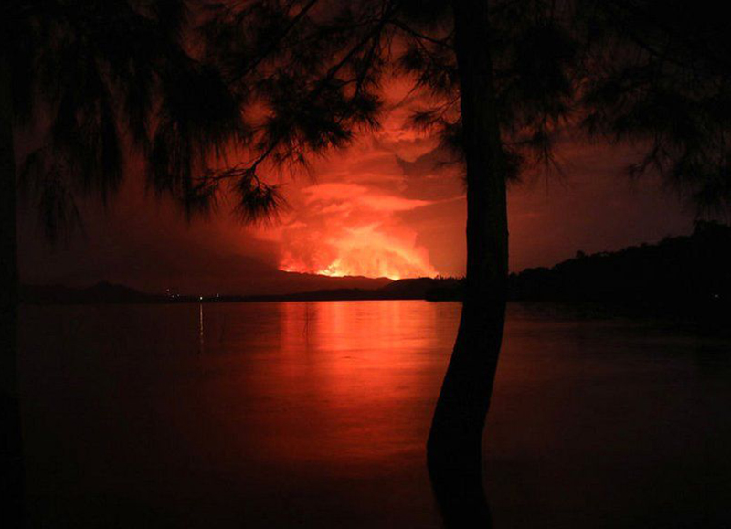 |
Figure 83. Photo of strong incandescence and an accompanying ash plume above Nyiragongo as seen from Tchegera Island on Lake Kivu outside Goma. Photo was published on 23 May 2021. Courtesy of AFP via BBC News. |
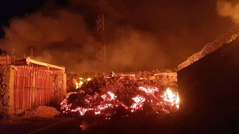 |
Figure 84. Photo showing the active lava flow from Nyiragongo destroying infrastructure as it traveled toward nearby villages on 22 May 2021. Courtesy of Enoch David, Reuters via BBC News. |
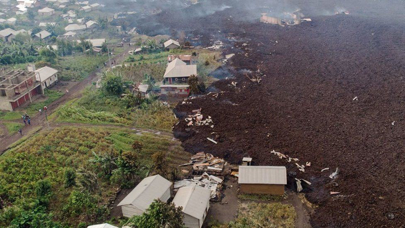 |
Figure 85. Aerial photo from 23 May 2021 showing a lava flow from Nyiragongo that traveled to the edge of Goma and destroyed nearby villages. Courtesy of AFP via BBC News. |
According to the Toulouse VAAC, ash plumes rose to 6.1-9.1 km during 22-23 May. Satellite images and local scientists indicated that the summit lava lake had drained before the flank fissures had opened but began refilling afterward; collapses in the summit crater were the likely cause of the ash plumes. MONUSCO (United Nations Stabilization Mission in the Democratic Republic of the Congo) carried out eight helicopter and two drone overflights during 22-25 May and captured an ash plume that rose to 6.1 km altitude above the volcano and drifted S; ground-based observers reported ash in the atmosphere above Goma (figure 86). Satellite data and analysis indicated that the lava flows around the crater during 22-23 May were the result of a N-S trending dike that had intruded beneath the volcano and Goma that likely extended below Lake Kivu. Seismic data during 22-24 May also showed events that propagated from the summit area to the S under Lake Kivu. Several strong earthquakes shook buildings in Goma, causing some to collapse and result in injuries. A news article reported that tremor was felt about every 30 minutes beginning around 1200 on 23 May.
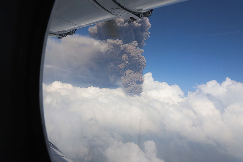 |
Figure 86. Photo of a strong ash plume rising above Nyiragongo taken from a helicopter overflight by MONUSCO. Photo was posted on 25 May 2021. Courtesy of MONUSCO. |
Two notable sulfur dioxide plumes that exceeded 2 Dobson Units (DUs) were detected by the TROPOMI instrument on the Sentinel-5P satellite on 23 and 24 May that drifted W (figure 87). On 24 May at 1037 an Mw 5.1 earthquake was detected beneath Lake Kivu. The VAAC noted that ashfall around the volcano and in surrounding towns was visible in satellite data, though it was difficult to detect due to clouds. According to a news article published on 24 May, the lava lake had refilled since the beginning of significant activity.
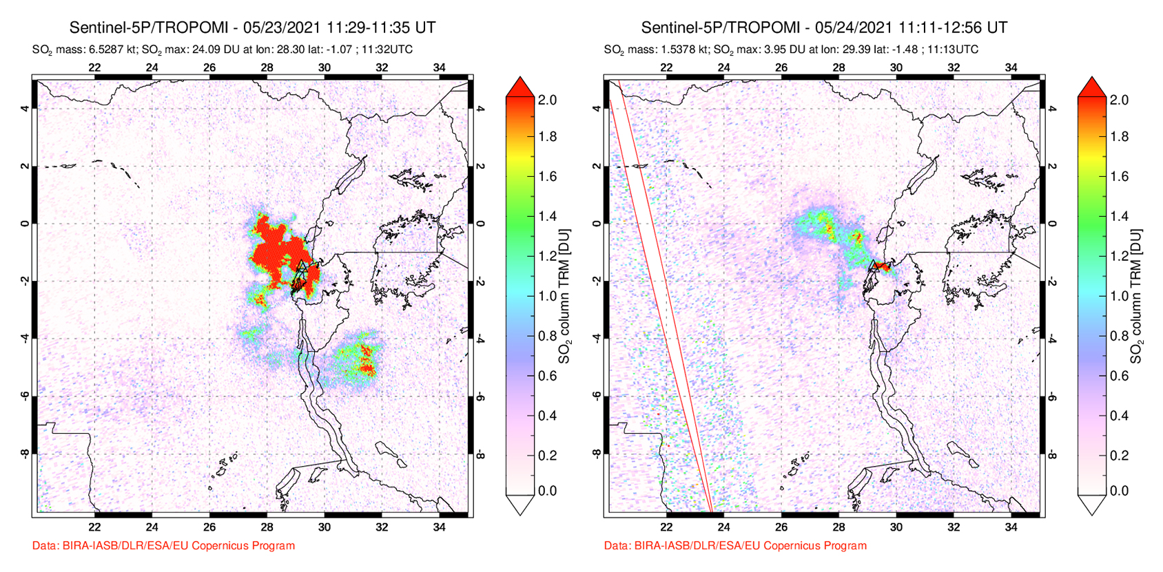 |
Figure 87. Two strong and distinct SO2 plumes from the Nyiragongo-Nyamulagira area were detected by the TROPOMI instrument on the Sentinel-5P satellite during 23 (left) and 24 (right) May 2021 on the days with strong explosive activity and ash plumes. The plumes drifted W. Courtesy of NASA Global Sulfur Dioxide Monitoring Page. |
Cracks a few tens of centimeters wide opened in different parts of the city on 25 May. The cracks measured several hundreds of meters long from the N city limit toward the lake and were nearly 100 m long near the airport. Some of these cracks were hot and emitted gas and others were flaming. Seismicity remained elevated on 25 May with more than 130 earthquakes between Mw 2 and 5 recorded in a 24-hour period, as well as a large number of smaller earthquakes. News reports indicated hundreds of damaged buildings in neighboring Rwanda (84 km SE). On 26 May 140 earthquakes were recorded with magnitudes ranging from 2.1-4.8 that had migrated S. A comparison of satellite radar images acquired on 23, 24, 25, and 26 May showed that the summit crater continued to widen after the partial drainage of the lava lake.
Intense seismicity continued to be reported even after lava effusion had stopped, which indicated that the dike continued to be active, according to GeoRiskA. Ground cracking in the city and damage to buildings from earthquakes continued to be reported. On 27 May authorities issued an evacuation of at least 400,000 residents in higher risk areas (about 10 districts) according to news organizations. Another strong ash plume drifting SW was visible that day in a Sentinel-2 satellite image (figure 88). During 28-29 May GeoRiskA reported that seismicity began to decrease and continued to decline through 1 June; both the seismic data and GPS data indicated that the dike was no longer propagating. Residents were able to start returning to their homes within a few days, according to a news article. The eruption had destroyed 3,629 homes, 12 schools, and 3 health facilities. More than 20,000 people were displaced, and at least 32 people had died.
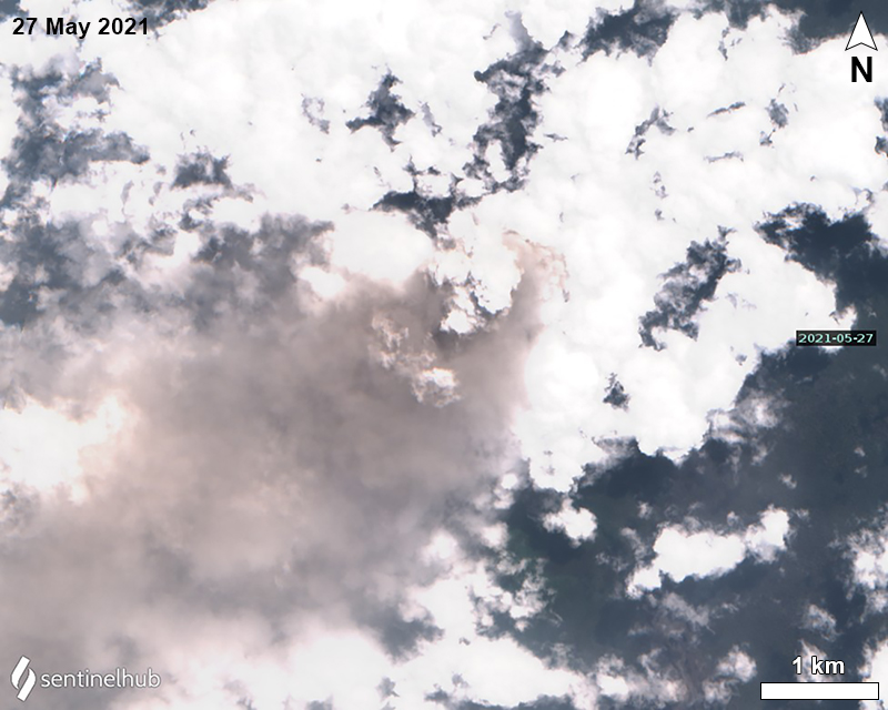 |
Figure 88. Sentinel-2 satellite image showed a strong ash plume (gray) rising from Nyiragongo on 27 May 2021 and drifted SW. Image using “Natural color” rendering (bands 4, 3, 2). Courtesy of Sentinel Hub Playground. |
Geological Summary. The Nyiragongo stratovolcano contained a lava lake in its deep summit crater that was active for half a century before draining catastrophically through its outer flanks in 1977. The steep slopes contrast to the low profile of its neighboring shield volcano, Nyamuragira. Benches in the steep-walled, 1.2-km-wide summit crater mark levels of former lava lakes, which have been observed since the late-19th century. Two older stratovolcanoes, Baruta and Shaheru, are partially overlapped by Nyiragongo on the north and south. About 100 cones are located primarily along radial fissures south of Shaheru, east of the summit, and along a NE-SW zone extending as far as Lake Kivu. Many cones are buried by voluminous lava flows that extend long distances down the flanks, which is characterized by the eruption of foiditic rocks. The extremely fluid 1977 lava flows caused many fatalities, as did lava flows that inundated portions of the major city of Goma in January 2002.
Information Contacts: Observatoire Volcanologique de Goma (OVG), Departement de Geophysique, Centre de Recherche en Sciences Naturelles, Lwiro, D.S. Bukavu, DR Congo; Georiska, Royal Museum for Central Africa, Leuvensesteenweg 13, 3080 Tervuren, Belgium (URL: http://www.africamuseum.be, https://georiska.africamuseum.be/en/news/nyiragongo_eruption); Le Parisien Libéré, 10, boulevard de Grenelle 75738 Paris Cedex 15 (URL: https://www.leparisien.fr/, https://www.leparisien.fr/international/volcan-nyiragongo-deux-longues-fissures-apparaissent-a-goma-25-05-2021-MQWNN2GXP5B7DEVMNUTTKHFACI.php); Euronews, 56, quai Rambaud, 69002 Lyon (URL: https://fr.africanews.com/, https://fr.africanews.com/2021/05/24/volcan-nyiragongo-un-seisme-de-magnitude-5-1-ressenti-au-rwanda/?utm_term=Autofeed&utm_medium=AfricanewsFR&utm_source=Twitter#Echobox=1621869737); BBC News (URL: https://www.bbc.com/news); Mission de l’Organisation des Nations Unies pour la Stabilisation en Rd Congo (MONUSCO), Kinshasa, DR Congo (URL: https://monusco.unmissions.org/); Reuters, Canary Wharf, London, United Kingdom (URL: https://www.reuters.com/, https://www.reuters.com/business/environment/tremors-shake-congo-city-close-schools-shops-after-volcanic-eruption-2021-05-24/); Volcano Disaster Assistance Program (VDAP), US Geological Survey (USGS), 1300 SE Cardinal Court, Bldg. 10, Suite 100, Vancouver, WA 98683; MIROVA (Middle InfraRed Observation of Volcanic Activity), a collaborative project between the Universities of Turin and Florence (Italy) supported by the Centre for Volcanic Risk of the Italian Civil Protection Department (URL: http://www.mirovaweb.it/); Toulouse Volcanic Ash Advisory Center (VAAC), Météo-France, 42 Avenue Gaspard Coriolis, F-31057 Toulouse cedex, France (URL: http://www.meteo.fr/aeroweb/info/vaac/); NASA Global Sulfur Dioxide Monitoring Page, Atmospheric Chemistry and Dynamics Laboratory, NASA Goddard Space Flight Center (NASA/GSFC), 8800 Greenbelt Road, Goddard, Maryland, USA (URL: https://so2.gsfc.nasa.gov/); Sentinel Hub Playground (URL: https://www.sentinel-hub.com/explore/sentinel-playground).