Report on Karangetang (Indonesia) — July 2021

Bulletin of the Global Volcanism Network, vol. 46, no. 7 (July 2021)
Managing Editor: Edward Venzke.
Edited by Kadie L. Bennis.
Karangetang (Indonesia) Frequent white gas-and-steam emissions, seismicity, and an ash plume on 29 January 2021
Please cite this report as:
Global Volcanism Program, 2021. Report on Karangetang (Indonesia) (Bennis, K.L., and Venzke, E., eds.). Bulletin of the Global Volcanism Network, 46:7. Smithsonian Institution. https://doi.org/10.5479/si.GVP.BGVN202107-267020
Karangetang
Indonesia
2.781°N, 125.407°E; summit elev. 1797 m
All times are local (unless otherwise noted)
Karangetang (also known as Api Siau), located on the island of Siau in the Sitaro Regency, North Sulawesi, Indonesia, consists of two active summit craters: Kawah Dua (the N crater) and Kawah Utama (the S crater, also referred to as the “Main Crater”). Its current eruption period began in November 2018 and has recently been characterized by occasional ash plumes, crater incandescence, an incandescent avalanche, and frequent gas-and-steam emissions (BGVN 45:12). This report updates information during December 2020 through May 2021, describing frequent white gas-and-steam emissions and a single ash plume based on reports from the Pusat Vulkanologi dan Mitigasi Bencana Geologi (PVMBG, also known as CVGHM, or the Center of Volcanology and Geological Hazard Mitigation), MAGMA Indonesia, the Darwin Volcanic Ash Advisory Center (VAAC), and satellite data.
Activity remained relatively low through May 2021 and was primarily characterized by gas-and-steam emissions and occasional ash plumes, according to PVMBG. Frequent gas-and-steam emissions rose 25-600 m above the Main Crater (S crater) during the reporting period and intermittent emissions rose 50-400 m above the N crater.
During December 2020, the volcano was often obscured by clouds and activity was primarily characterized by a low number of volcanic earthquakes, frequent white gas-and-steam emissions rising 50-250 m above the N crater, and occasional emissions rising 25-400 m above the Main Crater. According to PVMBG, seismicity declined during the month.
Similar low-level activity dominated by white gas-and-steam emissions and volcanic earthquakes continued into January 2021; weather often obscured views of the volcano. White gas-and-steam emissions rose 100-300 m above the Main Crater while those from the N crater rose 50-100 m above the crater rim. On 29 January pilots reported that an ash plume reached 2.4 km altitude and drifted SW. Ash plumes continued to be observed to 3 km altitude throughout the night into the 30th, based on satellite imagery, according to the Darwin VAAC.
White gas-and-steam emissions and occasional volcanic earthquakes continued during February through May (figure 50), though weather continued to frequently prevent clear views of the summit. White gas-and-steam emissions rose 25-600 m above the Main Crater and 25-400 m above the N crater. Due to the low-level of activity, PVMBG lowered the Volcano Alert Level to 2 (on a scale of 1-4) on 9 February.
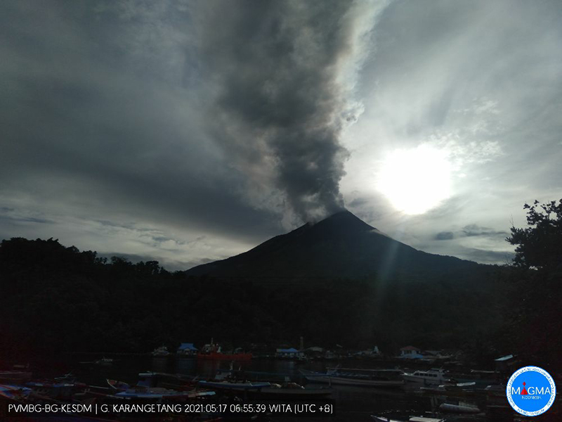 |
Figure 50. Webcam image of Karangetang showing a gas-and-steam plume rising 400 m above the summit on 17 May 2021. Courtesy of MAGMA Indonesia. |
MIROVA (Middle InfraRed Observation of Volcanic Activity) analysis of MODIS satellite data detected intermittent low-power thermal anomalies during the reporting period (figure 51). Sentinel-2 infrared satellite images also showed occasional weak thermal anomalies in the N summit crater and frequent gas-and-steam emissions from both summit craters (figure 52).
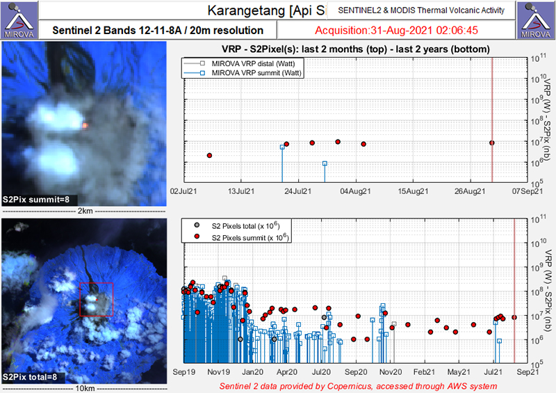 |
Figure 51. Intermittent thermal anomalies (red dots) were detected in the summit area of Karangetang during December 2020-May 2021 as recorded by the Sentinel-2 MODIS Thermal Volcanic Activity data (bands 12, 11, 8A). These anomalies were consistently low in power during the reporting period. Courtesy of MIROVA. |
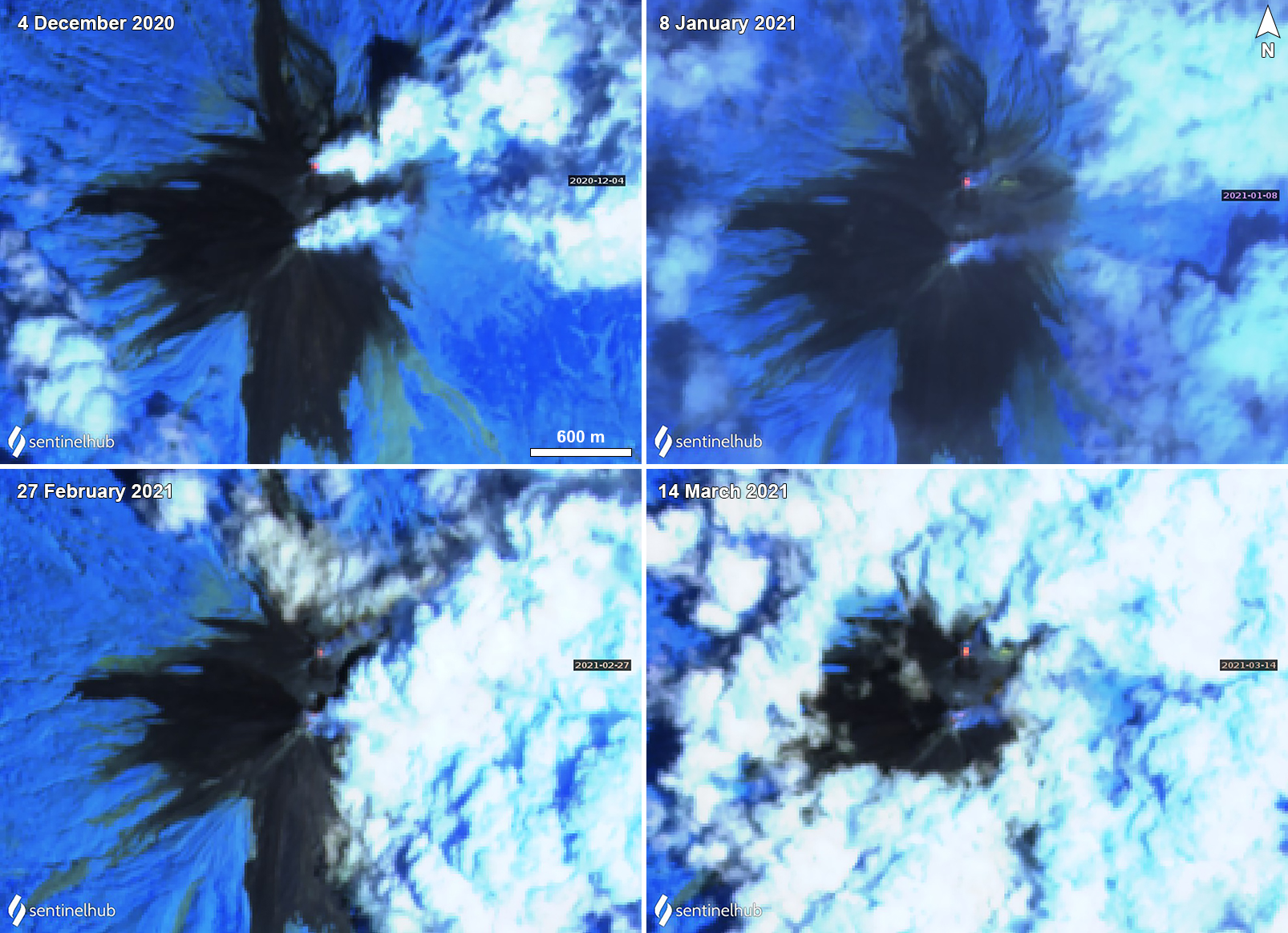 |
Figure 52. Small thermal anomalies (yellow-orange) at Karangetang were detected in the N summit crater on 4 December 2020 (top left), 8 January (top right), 27 February (bottom left), and 14 March (bottom right) 2021. Gas-and-steam emissions were observed from both summit craters drifting generally E on each of those dates; the Main Crater (S) summit crater was dominantly characterized by gas-and-steam emissions. Images using “Atmospheric penetration” rendering (bands 12, 11, 8a). Courtesy of Sentinel Hub Playground. |
Geological Summary. Karangetang (Api Siau) volcano lies at the northern end of the island of Siau, about 125 km NNE of the NE-most point of Sulawesi. The stratovolcano contains five summit craters along a N-S line. It is one of Indonesia's most active volcanoes, with more than 40 eruptions recorded since 1675 and many additional small eruptions that were not documented (Neumann van Padang, 1951). Twentieth-century eruptions have included frequent explosive activity sometimes accompanied by pyroclastic flows and lahars. Lava dome growth has occurred in the summit craters; collapse of lava flow fronts have produced pyroclastic flows.
Information Contacts: Pusat Vulkanologi dan Mitigasi Bencana Geologi (PVMBG, also known as Indonesian Center for Volcanology and Geological Hazard Mitigation, CVGHM), Jalan Diponegoro 57, Bandung 40122, Indonesia (URL: http://www.vsi.esdm.go.id/); MAGMA Indonesia, Kementerian Energi dan Sumber Daya Mineral (URL: https://magma.esdm.go.id/v1); Darwin Volcanic Ash Advisory Centre (VAAC), Bureau of Meteorology, Northern Territory Regional Office, PO Box 40050, Casuarina, NT 0811, Australia (URL: http://www.bom.gov.au/info/vaac/); MIROVA (Middle InfraRed Observation of Volcanic Activity), a collaborative project between the Universities of Turin and Florence (Italy) supported by the Centre for Volcanic Risk of the Italian Civil Protection Department (URL: http://www.mirovaweb.it/); Sentinel Hub Playground (URL: https://www.sentinel-hub.com/explore/sentinel-playground).