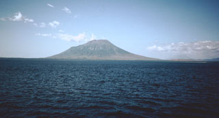
Lewotolok
Indonesia
8.274°S, 123.508°E; summit elev. 1431 m
All times are local (unless otherwise noted)
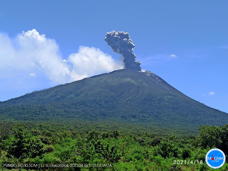
A brief period of ash emissions in January 2012 was the first documented activity in over 50 years (BGVN 36:12) at Lewotolok (also known as Lewotolo), on the island of Lembata (Lomblen) in the Lesser Sunda Islands of Indonesia. Between then and November 2020, intermittent thermal activity was identified using MODVOLC and Sentinel-2 infrared data (BGVN 41:09, 46:02) and a single episode of increased seismicity was noted by PVMBG in October 2017. The only emissions reported were white steam and gas plumes rising up to 500 m above the summit crater. Increased seismicity at the end of November 2020 was accompanied by explosions with ash plumes and incandescent ejecta (BGVN 46:02) that resulted in ashfall and evacuations from surrounding communities. Explosions with ash emissions rising up to 1,500 m and incandescent ejecta rising 600 m above the crater were reported through the end of January 2021. This report covers similar explosive activity that continued from February-July 2021 with information provided by Pusat Vulkanologi dan Mitigasi Bencana Geologi (PVMBG, also known as CVGHM, or the Center of Volcanology and Geological Hazard Mitigation), MAGMA Indonesia, and satellite data.
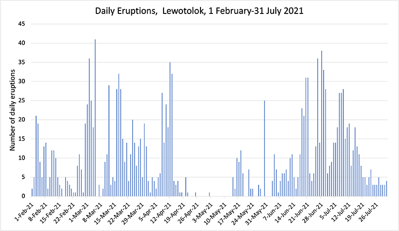
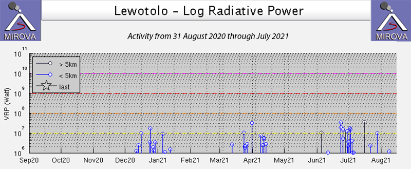
Multiple daily explosions were reported throughout February-July 2021 except for a brief pause during late April and early May (figure 13). Multi-day periods of incandescent ejecta rising hundreds of meters above the summit and extending a similar distance from the crater continued in February and increased to near-daily during June and July; multiple episodes of ejecta fell 1 km from the crater rim. Dense gray and black ash plumes were infrequent in January and February but increased to multiple times a day in mid-March, rising 1,000-1,500 m above the summit; the highest plume of the period reached over 3 km above the summit on 13 June. Daily explosive activity with ash plumes and incandescent ejecta continued through the end of July. Thermal anomalies in MIROVA data indicated pulses of higher activity during March-early April and late June-July (figure 14). Satellite imagery provided thermal and visual evidence of fresh lava flow activity inside the summit crater on multiple occasions.
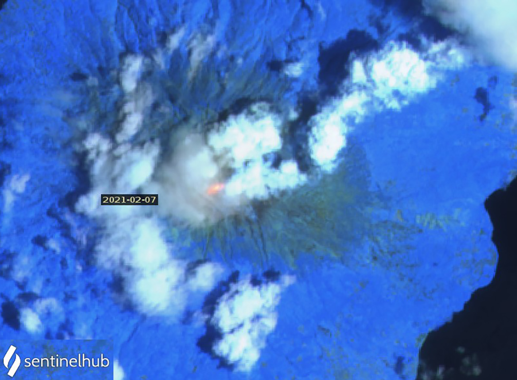
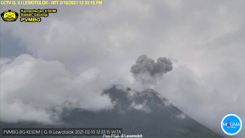
Activity during February-April 2021. PVMBG reported daily white and gray emissions that rose 200-700 m above the summit, and occasionally higher, during February 2021. Explosions occurred virtually every day with a maximum of 21 reported on 3 February, but 5-10 per day were typical. During 5-9 February loud noises accompanied bursts of incandescent ejecta that rose 300 m above the summit and extended 300-500 m SE (figure 15). MAGMA Indonesia reported an eruption on 10 February that produced an ash plume that rose 700 m and drifted E (figure 16). Thermal anomalies appeared in satellite images on 7, 12, 17, and 22 February.
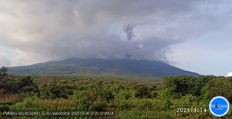
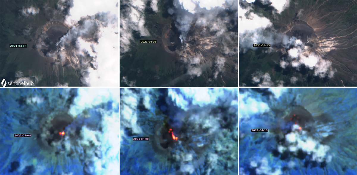
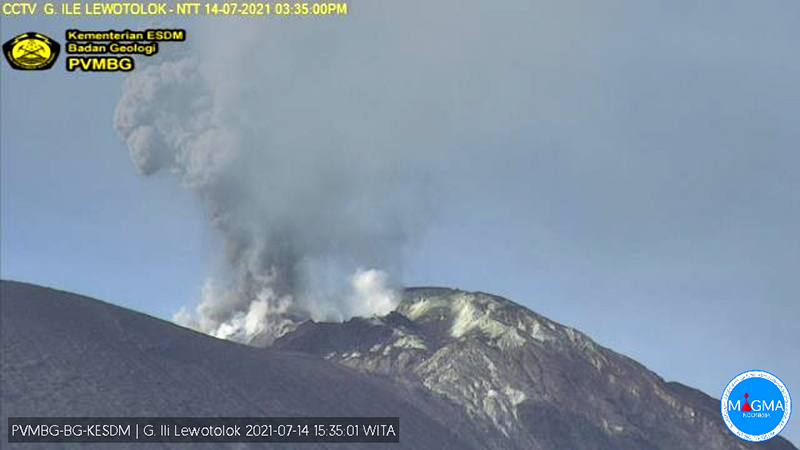
The abrupt increase in the number of daily explosions at the beginning of March 2021 was accompanied by loud rumbling noises and observations of incandescent ejecta. During 2-5 March incandescent ejecta rose 200-800 m above the summit towards the SE. On 9 March the ejecta was reported 1,300 m E and SE of the summit. From 11-15 March the incandescent ejecta rose 500 m above the crater rim and was ejected as far as 1,000 m E and SE. The Darwin VAAC reported ash plumes on 13 and 14 March that drifted SW at 1.2 km altitude. MAGMA Indonesia reported two explosions, one on 14 March that rose 1,300 m above the summit and drifted S (figure 17) and one on 15 March that rose 1,000 m and drifted E. During 19-31 March there were 4-20 explosions each day that produced audible booms and rumbling; incandescent ejecta rose as high as 500 m and was thrown the same distance E and SE. Thermal anomalies at the center of the summit crater were apparent in Sentinel-2 satellite imagery on 4 and 19 March.
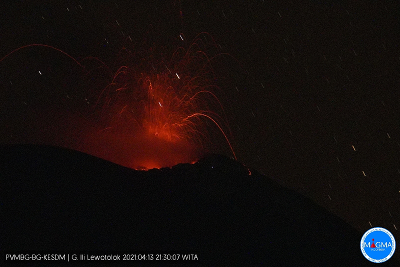
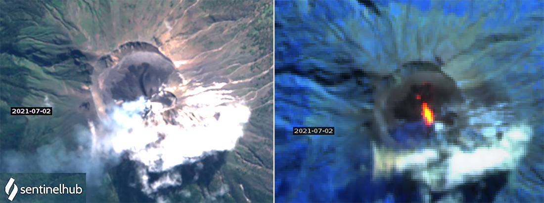
Cloudy weather obscured views of the summit for several days in early April 2021, but during 5-17 April multiple daily explosions produced incandescent ejecta often reaching 500 m high, loud noises, and dense gray and black ash plumes (figure 18). Sentinel-2 imagery indicated thermal anomalies inside the summit crater likely caused by fresh lava flows on 8 April. The thermal anomalies and visual imagery from 13 April revealed a new dark area, still hot around the edges, that also likely represented fresh lava (figure 19). Ejecta reached 300-500 m E and SE of the summit during 8-12 April; on 16 April PVMBG reported incandescent ejecta 1,000 m above the summit. MAGMA Indonesia noted one to five eruptions each day during 12-18 April; dense white, gray, and black ash plumes rose 500-1,500 m above the summit and drifted W or SW most days. The Darwin VAAC reported ash emissions on 15 and 16 April which rose 400-700 m above the summit and drifted WNW, and a plume that rose to 3,000 m altitude (1,500 m above the summit) on 18 April and drifted W (figure 20). Additional explosions were reported on 20-21 and 24-25 April, producing gray and black ash plumes that rose 600-1,000 m above the summit. By 28 April only steam emissions were observed, and no thermal anomalies were present around the fresh dark flow visible inside the summit crater.
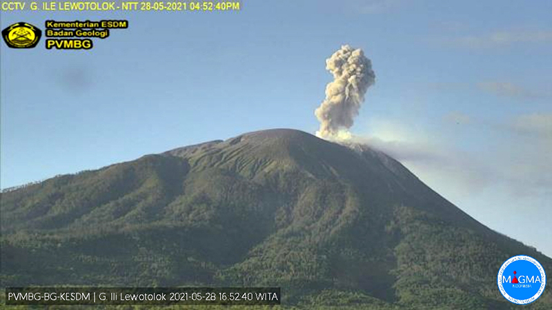
Activity during May-July 2021. A single explosion reported by PVMBG and Magma Indonesia on 2 May caused a VONA and a VAAC report to be issued. The ash plume rose 500-600 m above the summit and drifted W. Lewotolok was quiet with white and gray emissions, and no explosions reported, until 14 May when incandescent ejecta and ash emissions resumed for the rest of the month. Strombolian activity accompanied by loud noises sent incandescent ejecta 300 m high and 400-700 m SE from the summit; satellite imagery from 18 May showed a small thermal anomaly inside the summit crater. The ash plumes from the multiple explosions were dense and gray, and rose 400-800 m high. The Darwin VAAC reported multiple ash emissions during 21-25 and 28-29 May that were clearly seen in satellite imagery extending SE, S, or SW at 2,100 m altitude; the plume on 28 May (figure 21) rose 1,000 m above the summit to about 2,400 m altitude and drifted SW.
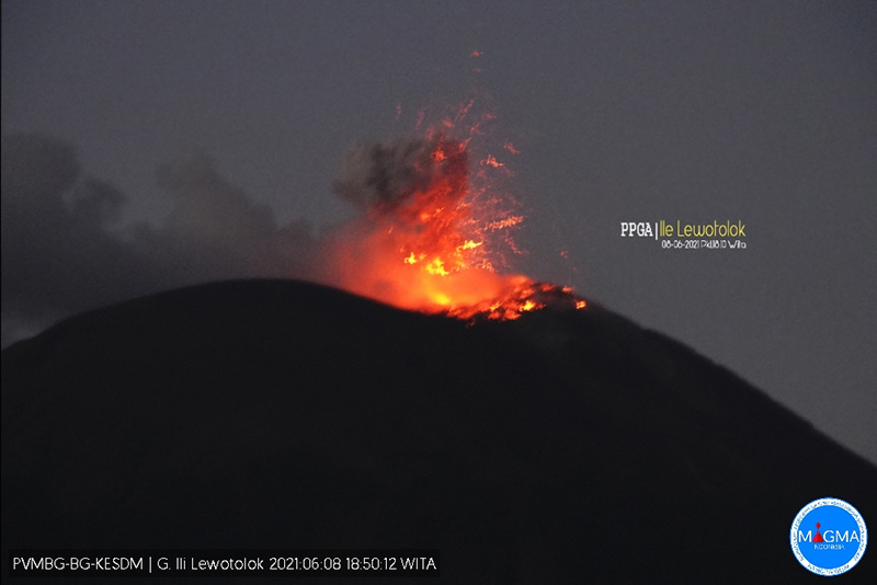
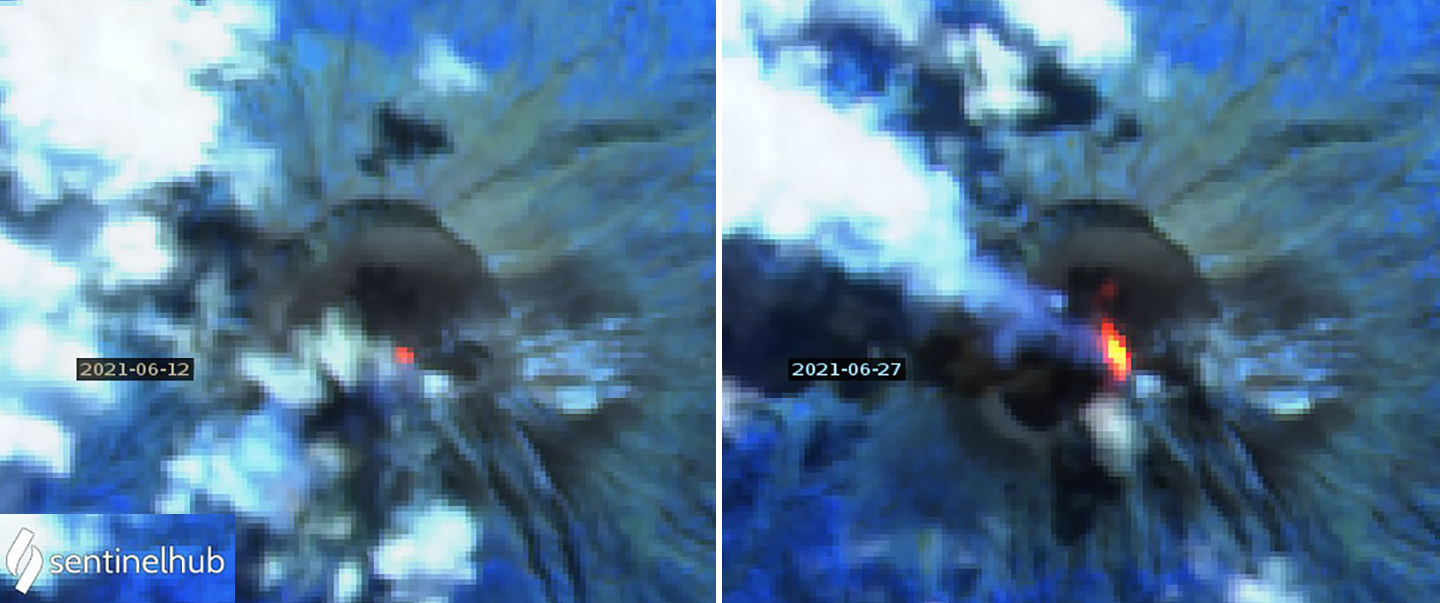
Multiple explosions with either ash plumes or Strombolian activity were reported daily throughout June 2021. During 1-9 June incandescent ejecta fell at least 300 m in all directions from the summit with loud noises reported (figure 22). On 5 June the 300-m-high ejecta reached 1,000 m NW and 200 m SE. During 8-16 June eruptions with ash plumes were reported by MAGMA Indonesia; both VONA’s and VAAC reports were issued each day. The white and gray ash emissions generally rose 500-800 m above the summit. On 10, 14, and 21 June the plumes were reported 2,000 m above the summit drifting W and NW. An explosion on 13 June produced an ash plume to 3 km above the summit, the highest of the period, that was observed drifting W in satellite imagery at 4.9 km altitude. Rumbling reported during 16-20 June accompanied incandescent ejecta sent 300-500 m in all directions from the crater. On 2, 7, 12, and 27 June thermal anomalies appeared in Sentinel-2 imagery inside the summit crater; the strong anomaly on 27 June suggested new flow activity (figure 23).
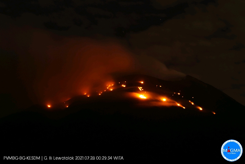
Heightened levels of activity continued throughout July 2021. Thermal and visual evidence of fresh lava flows inside the summit crater appeared in satellite images on 2 July (figure 24). Additional thermal anomalies were recorded on 12, 22, and 27 July. Bursts of incandescent ejecta frequently caused loud noises. Vegetation caught fire around the summit from incandescent material on 3 and 28 July (figure 25). The tephra was usually reported 300-500 m from the crater but was sent 1,000 m SW on 3 July, and 1,000 m SE on 12, 18, 28, and 30 July. Five or more explosions were reported daily by PVMBG during 1-20 July, with a maximum of 28 reported on 9 July. The dense gray or gray-and-black ash emissions consistently rose 800-1,000 m above the summit, usually drifting W or NW (figure 26). The tallest plume on 7 July was reported by MAGMA Indonesia at 1,100 m above the summit, drifting E.
Geological Summary. The Lewotolok (or Lewotolo) stratovolcano occupies the eastern end of an elongated peninsula extending north into the Flores Sea, connected to Lembata (formerly Lomblen) Island by a narrow isthmus. It is symmetrical when viewed from the north and east. A small cone with a 130-m-wide crater constructed at the SE side of a larger crater forms the volcano's high point. Many lava flows have reached the coastline. Eruptions recorded since 1660 have consisted of explosive activity from the summit crater.
Information Contacts: Pusat Vulkanologi dan Mitigasi Bencana Geologi (PVMBG, also known as Indonesian Center for Volcanology and Geological Hazard Mitigation, CVGHM), Jalan Diponegoro 57, Bandung 40122, Indonesia (URL: http://www.vsi.esdm.go.id/); MAGMA Indonesia, Kementerian Energi dan Sumber Daya Mineral (URL: https://magma.esdm.go.id/v1); MIROVA (Middle InfraRed Observation of Volcanic Activity), a collaborative project between the Universities of Turin and Florence (Italy) supported by the Centre for Volcanic Risk of the Italian Civil Protection Department (URL: http://www.mirovaweb.it/); Sentinel Hub Playground (URL: https://www.sentinel-hub.com/explore/sentinel-playground).