Report on Santa Maria (Guatemala) — August 2021

Bulletin of the Global Volcanism Network, vol. 46, no. 8 (August 2021)
Managing Editor: Edward Venzke.
Edited by A. Elizabeth Crafford.
Santa Maria (Guatemala) Blocky lava extrusion continues daily during February-July 2021
Please cite this report as:
Global Volcanism Program, 2021. Report on Santa Maria (Guatemala) (Crafford, A.E., and Venzke, E., eds.). Bulletin of the Global Volcanism Network, 46:8. Smithsonian Institution. https://doi.org/10.5479/si.GVP.BGVN202108-342030
Santa Maria
Guatemala
14.757°N, 91.552°W; summit elev. 3745 m
All times are local (unless otherwise noted)
The dacitic Santiaguito lava-dome complex of Guatemala's Santa María volcano has been actively erupting since 1922. It formed within a large crater on the SW flank which was created during the VEI 6 1902 eruption. Ash explosions, pyroclastic, and lava flows have emerged from Caliente, the youngest of the four vents in the complex, for more than 40 years. The Caliente vent is at about 2.5 km elevation, and the summit of Santa Maria is around 3.7 km elevation. A lava dome that appeared within the summit crater of Caliente in October 2016 has continued to grow, producing frequent block avalanches down the flanks. Daily explosions with ash plumes and block avalanches continued during February-July 2021, the period covered in this report, with information primarily from Guatemala's INSIVUMEH (Instituto Nacional de Sismologia, Vulcanologia, Meterologia e Hidrologia).
Blocky lava extrusion from the active dome inside the summit crater of Caliente persisted throughout February-July 2021. This resulted in ongoing block avalanches and ash that descended primarily the W and SW flanks of Caliente, and occasionally the S and SE flanks. Material frequently reached the base and resulted in fine-grained ashfall and suspended ash around the perimeter. Near-constant degassing of water vapor and magmatic gases occasionally contained small amounts of ash; plumes rose to 3.0-3.2 km altitude (up to 700 m above the summit of Caliente) and drifted in multiple directions. Sounds similar to a turbine engine from the constant degassing were reported on most days. Explosions with gas and ash occurred almost daily; the plumes rose to 3.0-3.6 km altitude, and a few drifted up to 10-15 km, producing ashfall in nearby communities before dissipating. Thermal activity remained constant through May, dropped off in June, and returned to typical levels in July 2021 (figure 122).
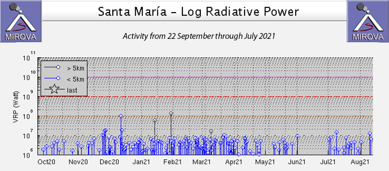 |
Figure 122. Steady levels of thermal activity persisted at Santa Maria from December 2020 through May 2021 as seen in the graph of Log Radiative Power produced by the MIROVA project from 22 September 2020 through July 2021. Activity declined in June and returned to typical levels in July 2021. Courtesy of MIROVA. |
Ashfall was reported in El Faro (7 km SSW), Aldea Las Marias (10 km S), and El Viejo Palmar (10 km S) on 5 February 2021. The next day a small pyroclastic flow was reported early in the morning on the W flank. The Washington VAAC reported an ash emission that rose to 4.6 km altitude on 7 February. It was seen moving WSW and extending approximately 15 km from the summit before dissipating later in the day. This was the only VAAC report issued for the reporting period. In a special bulletin that day INSIVUMEH noted pyroclastic flows on the SW flank that reached the head of the Rio San Isidro drainage (figure 123). They also reported ash moving SW reaching Finca Montebello, Loma Linda (7 km SW), and San Marcos Palajunoj (8 km SW). On 10 February ashfall was reported in Palajunoj. A thermal anomaly seen in Sentinel-2 satellite imagery extended down the W flank on 16 February (figure 124), likely from either incandescent blocks or a pyroclastic flow. A strong sulfur odor was noted in the area around Las Marias on 20 February. Weak pyroclastic flows affected the E and W flanks of the Caliente on 22 February; ash plumes drifted 2.5 km SW on 26 February.
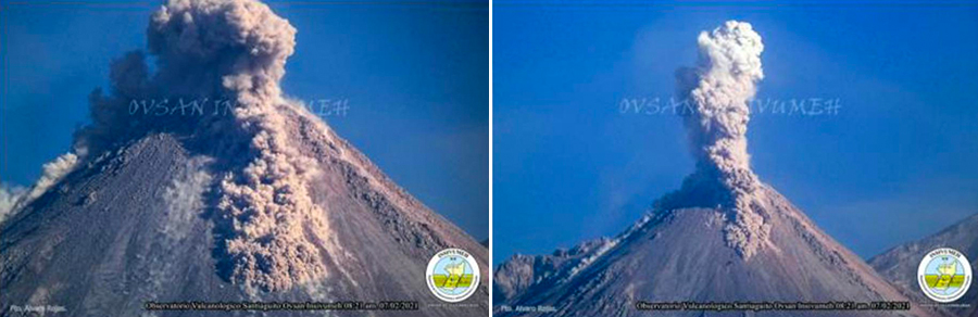 |
Figure 123. Explosions produced ash plumes and pyroclastic flows at the Caliente vent of Santa Maria on 7 February 2021. Courtesy of INSIVUMEH (Special Bulletin BESAN-007-2021, 7 February 2021). |
 |
Figure 124. A linear thermal anomaly was apparent on the W flank of the Caliente dome at Santa Maria on 16 February 2021. It was likely due to either incandescent blocks or a pyroclastic flow. Image uses Atmospheric penetration rendering (bands 12, 11, 8a). Courtesy of Sentinel Hub Playground. |
The loud noises from constant degassing were heard in El Palmar on 4 March 2021; ash plumes that day drifted up to 2 km SW. Thermal anomalies appeared in satellite data inside the summit crater of Caliente on 8 and 23 March. Explosions with ash on 9 March rose to 3.0 km altitude and drifted S and SW (figure 125). On 22 March ashfall was reported in Aldea Las Maria, Calaguache, and other nearby communities. Ashfall was reported on 25 and 27 March in Aldeas San Marcos and Loma Linda Palajunoj.
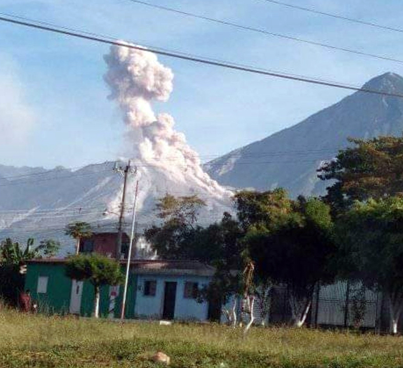 |
Figure 125. An explosion at the Caliente dome of Santa Maria’s Santiaguito complex on 9 March 2021 rose to 3 km altitude and drifted S and SW Photograph by Lluis Lopez, taken from El Palmar, Quetzaltenango, courtesy of Stereo100Noticias. |
Ash plume heights were slightly higher during April 2021, reaching 3.5 or 3.6 km altitude on most days, especially during the second half of the month. Resuspended ash from debris descending the flanks of Caliente dome produced ashfall in Viejo Palmar on 2 April. Sentinel-2 satellite imagery showed a thermal anomaly inside the summit crater that day as well. On 6 April ash plumes drifted 2.5 km SW before dissipating. On 13 and 16 April ashfall was reported in Aldeas San Marcos, Loma Linda Palajunoj, and other nearby communities. INSIVUMEH released a Special Bulletin on 18 April about a lahar that descended Rio San Isidro, carrying branches, tree trunks, volcanic ash, and blocks 1-2 m in diameter.
Ashfall was reported on 1, 6, 11, 16, 21, 26, and 31 May 2021 in Aldeas San Marcos, Loma Linda Palajunoj and other nearby communities from frequent ash plumes that rose to 3.4-3.6 km altitude and drifted SW (figure 126). Increased rainfall resulted in lahars reported on 15, 16, 24, and 30 May. The lahars on 15 and 16 May descended the Rio Cabello de Angel drainage. Branches, trunks, and volcanic blocks 1-3 m in diameter caused vibrations as they passed the seismic stations on 15 May; the next day the flow was a 25-m-wide and 1 m high pasty slurry of sulfur-smelling material full of ash and blocks from 30 cm to 1 m in diameter. The lahar on 24 May descended Rio Tambor and Rio San Isidro with tree trunks, branches, volcanic ash, and blocks 1-2 m in diameter. On 30 May heavy precipitation produced a lahar in Rio San Isidro that occurred near the Finca Filadelfia as a pasty mixture of water, blocks up to 1 m in diameter, and fine sediment, along with branches and tree trunks. A thermal anomaly was present in satellite imagery inside the summit crater on 27 May.
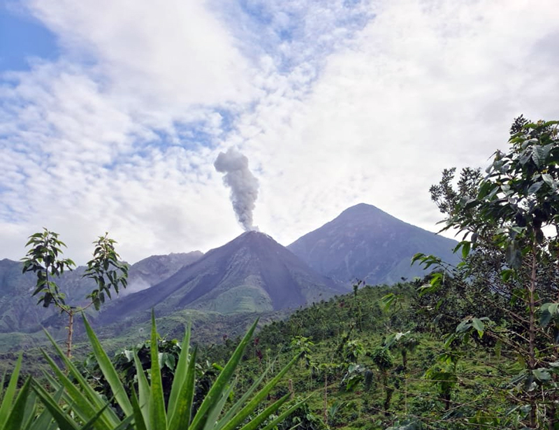 |
Figure 126. Weak explosions of ash on 31 May 2021 rose to 2.8 km altitude, drifted 5 km SW, and fine-grained ash fell in San Marcos and Loma Linda. Courtesy of CONRED . |
The ash explosions reported on 5 June 2021 rose to 2.8 km altitude and drifted 7 km SW resulting in ashfall in Aldeas San Marcos and Loma Linda Palajunoj. Ashfall was reported in the mountainous areas of Monte Claro on 8 June from plumes that reached 3.6 km altitude and drifted W and SW. On 12 and 13 June lahars descended the Rio Nima 1 (figure 127). Rio Cabello de Angel and Nima 1 were the sites of lahars on 15 June where fine-grained material and blocks 30 cm to 1 m in diameter moved down the drainages in a 1-m-deep and 20-m-wide slurry. On 15 June ashfall was reported in Calaguache and Santa Maria de Jesus (5 km SE), and on 20 and 25 June it was again reported in Loma Linda and San Marcos Palajunoj. Another lahar descended Rio Cabello de Angel and Nima 1 on 29 June after rainfall on the upper parts of the volcano. Thermal anomalies were present in Sentinel-2 satellite images inside the summit crater of Caliente on 11 and 26 June.
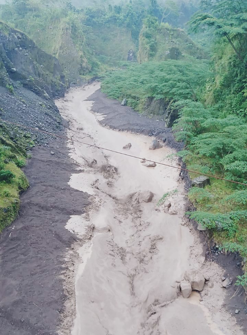 |
Figure 127. On 12 June 2021 a lahar of mud and debris descended the Nimá 1 river channel near Finca El Faro. Photo by Edgar Cabrera from COLRED at Finca El Faro, El Palmar, Quetzaltenango. Courtesy of Rony Veliz. |
During July 2021 incandescence around the summit crater of Caliente was reported more frequently than during the previous months. The constant block avalanches continued from the extruding lava primarily on the W, SW, and S flanks with some blocks reaching the base and producing ash plumes. On 5, 10, 15, 20, and 30 July ash plumes from explosions drifted 8-12 km W and SW and caused ashfall in Loma Linda and San Marcos (figure 128). The extrusion of blocky lava from the crater was reported as a 600-700 m long flow on the W flank on 10, 15, and 25 July. A lahar on 14 July in the El Tambor ravine was a pasty mixture of water, blocks up to 3 m in diameter, and fine sediments that produced seismic vibrations. Sulfur odors occurred in Las Marias on 20 and 25 July. Thermal anomalies at the summit were recorded in satellite images on 6, 16, and 31 July.
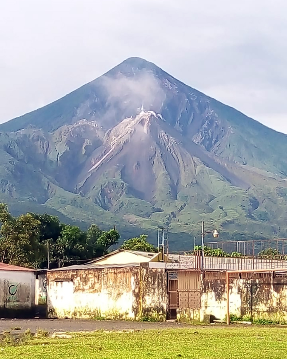 |
Figure 128. Norma Cardona of COLRED San Marcos Palajunoj El Palmar Quetzaltenango, reported that on 5 July 2021 the Caliente dome of Santiaguito was weakly degassing with minor ash drifting W. Ashfall was reported in communities to the SW that day. Courtesy of Frídel Mejicanos. |
Geological Summary. Symmetrical, forest-covered Santa María volcano is part of a chain of large stratovolcanoes that rise above the Pacific coastal plain of Guatemala. The sharp-topped, conical profile is cut on the SW flank by a 1.5-km-wide crater. The oval-shaped crater extends from just below the summit to the lower flank, and was formed during a catastrophic eruption in 1902. The renowned Plinian eruption of 1902 that devastated much of SW Guatemala followed a long repose period after construction of the large basaltic andesite stratovolcano. The massive dacitic Santiaguito lava-dome complex has been growing at the base of the 1902 crater since 1922. Compound dome growth at Santiaguito has occurred episodically from four vents, with activity progressing E towards the most recent, Caliente. Dome growth has been accompanied by almost continuous minor explosions, with periodic lava extrusion, larger explosions, pyroclastic flows, and lahars.
Information Contacts: Instituto Nacional de Sismologia, Vulcanologia, Meteorologia e Hydrologia (INSIVUMEH), Unit of Volcanology, Geologic Department of Investigation and Services, 7a Av. 14-57, Zona 13, Guatemala City, Guatemala (URL: http://www.insivumeh.gob.gt/); MIROVA (Middle InfraRed Observation of Volcanic Activity), a collaborative project between the Universities of Turin and Florence (Italy) supported by the Centre for Volcanic Risk of the Italian Civil Protection Department (URL: http://www.mirovaweb.it/); Sentinel Hub Playground (URL: https://www.sentinel-hub.com/explore/sentinel-playground); Washington Volcanic Ash Advisory Center (VAAC), Satellite Analysis Branch (SAB), NOAA/NESDIS OSPO, NOAA Science Center Room 401, 5200 Auth Rd, Camp Springs, MD 20746, USA (URL: www.ospo.noaa.gov/Products/atmosphere/vaac, archive at: http://www.ssd.noaa.gov/VAAC/archive.html); CONRED, Coordinadora Nacional para la reduccion de desastres (URL: https://conred.gob.gt/, https://twitter.com/ConredGuatemala/status/1399369155544076295 ); Stereo100Noticias (URL: https://twitter.com/stereo100xela/status/1369295245272363014); Rony Veliz (URL: https://twitter.com/ronyveliz692/status/1403836189841494019); Frídel Mejicanos (URL: https://twitter.com/FridelMejicanos/status/1412189491289264129).