Report on Manam (Papua New Guinea) — November 2021

Bulletin of the Global Volcanism Network, vol. 46, no. 11 (November 2021)
Managing Editor: Edward Venzke.
Edited by Kadie L. Bennis.
Manam (Papua New Guinea) Explosion on 20 October 2021 included a strong ash plume and debris flow
Please cite this report as:
Global Volcanism Program, 2021. Report on Manam (Papua New Guinea) (Bennis, K.L., and Venzke, E., eds.). Bulletin of the Global Volcanism Network, 46:11. Smithsonian Institution. https://doi.org/10.5479/si.GVP.BGVN202111-251020
Manam
Papua New Guinea
4.08°S, 145.037°E; summit elev. 1807 m
All times are local (unless otherwise noted)
Eruptions from Manam, located 13 km off the N coast of mainland Papua New Guinea, have been recorded since 1616. It contains two active summit craters, Main and South, which have produced occasional Strombolian activity, lava flows, pyroclastic avalanches, and ash plumes. The current eruption period has been ongoing since 2014, with more recent activity including a strong explosion on 20 October 2021, intermittent ash plumes, sulfur dioxide plumes, and thermal anomalies (BGVN 46:06). This report describes similar activity during April through October 2021 using information primarily from the Rabaul Volcano Observatory (RVO), the Darwin Volcanic Ash Advisory Center (VAAC), and various satellite data.
Activity during May through September was relatively low and primarily consisted of persistent thermal anomalies in the summit craters, infrequent ash plumes (figure 82), and gas-and-steam emissions. Intermittent sulfur dioxide plumes were also detected using the TROPOMI instrument on the Sentinel-5P satellite, some of which reached at least two Dobson Units (DU) and drifted in different directions (figure 83). During 20-21 May an ash plume rose to 2.1 km altitude and drifted NW, based on HIMAWARI-8 satellite data. The next Darwin VAAC notice reported a continuous ash plume rising to 2.1-2.4 km altitude and drifting W, WNW, and NW during 23-24 June. RVO reported small sporadic ash emissions rising from the Southern Crater beginning at the end of September.
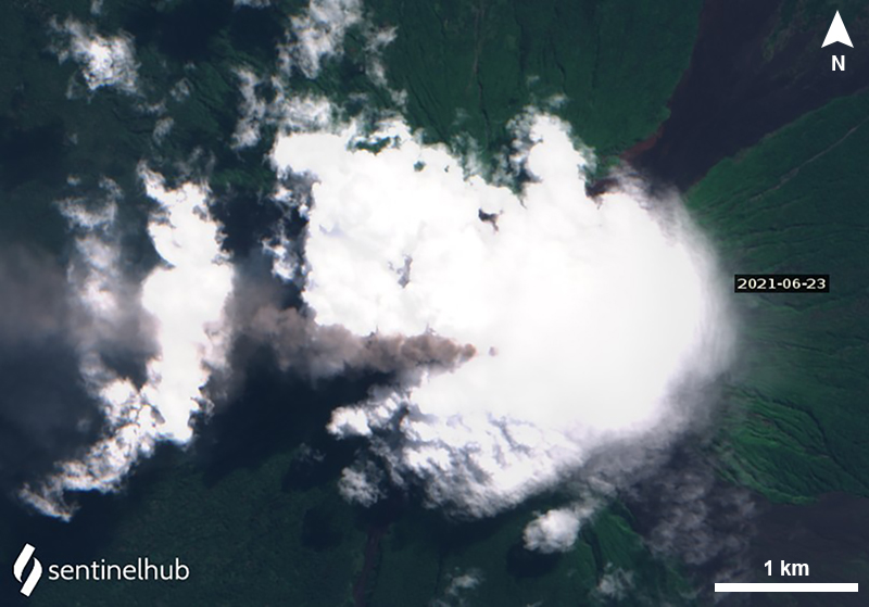 |
Figure 82. Sentinel-2 satellite image showing a dark gray ash plume drifting W from Manam on 23 June 2021. Image using “Natural Color” (bands 4, 3, 2) rendering. Courtesy of Sentinel Hub Playground. |
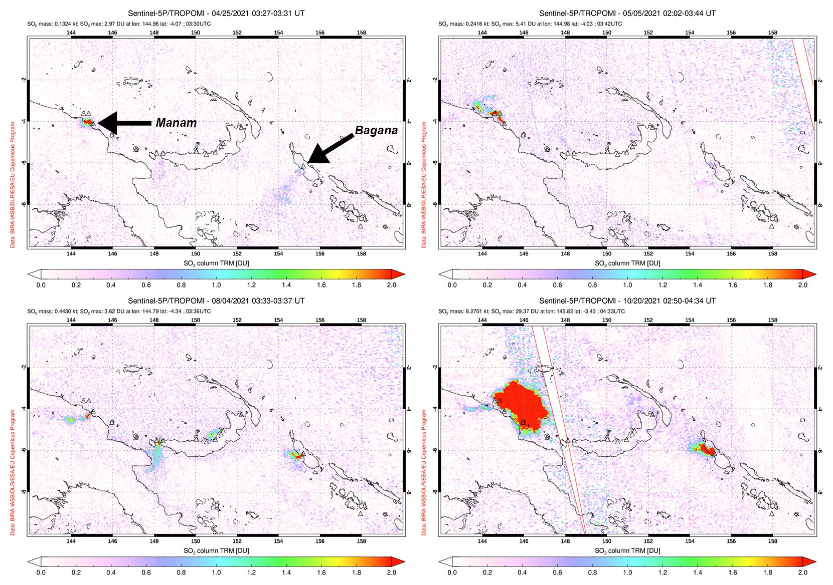 |
Figure 83. Small but distinct sulfur dioxide plumes rising from Manam and drifting in different directions were detected using data from the TROPOMI instrument on the Sentinel-5P satellite on 25 April (top left), 5 May (top right), 4 August (bottom left), and 20 October (bottom right) 2021. During the explosion on 20 October, a strong sulfur dioxide plume was visible with a mass of 8.3 kilotons over the volcano. Courtesy of the NASA Global Sulfur Dioxide Monitoring Page. |
Activity during October increased; starting on 8 October nighttime incandescence began and incandescent material was occasionally ejected from the crater. RVO characterized this activity as moderately Strombolian, as incandescent ejecta was reported rolling down the SW Valley (figure 84), which was also noted in Sentinel-2 infrared satellite imagery on 16 October (figure 85). On 18 October an ash plume rose to 2.4 km altitude and drifted NW based on information from the Darwin VAAC. At 0800 on the morning of 20 October RVO detected a large explosion at the Southern Crater, producing ash plumes that rose at least 1 km above the summit and drifted N and NW. According to the Darwin VAAC, an initial ash plume was reported to 2.1 km altitude and drifted W, which was accompanied by a thermal hotspot seen in infrared satellite imagery. Later that day an ash plume was detected, rising to at least 15.2 km altitude, which expanded radially, and drifted E. Lower-level plumes rose to 4.3-5.5 km altitude extending to the NW. Collapses of both the newly erupted material collapsed, and deposits from the previous weeks, generated a debris flow from the head of the valley down the SW flank. The strong ash plume continued into the next day on 21 October that rose to 10.7-15.2 km altitude while the lower-level plumes rose to 4.6 km altitude and drifted W. After the main ash plume dispersed, ground-based observers reported ongoing smaller ash emissions that rose to 2.4 km altitude on 21 October.
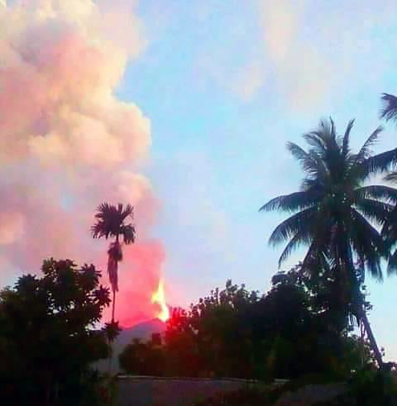 |
Figure 84. Photo of incandescent ejecta rising above Manam due to the large explosion on 20 October 2021. Courtesy of Robert Baim and Norbert Ngasi. |
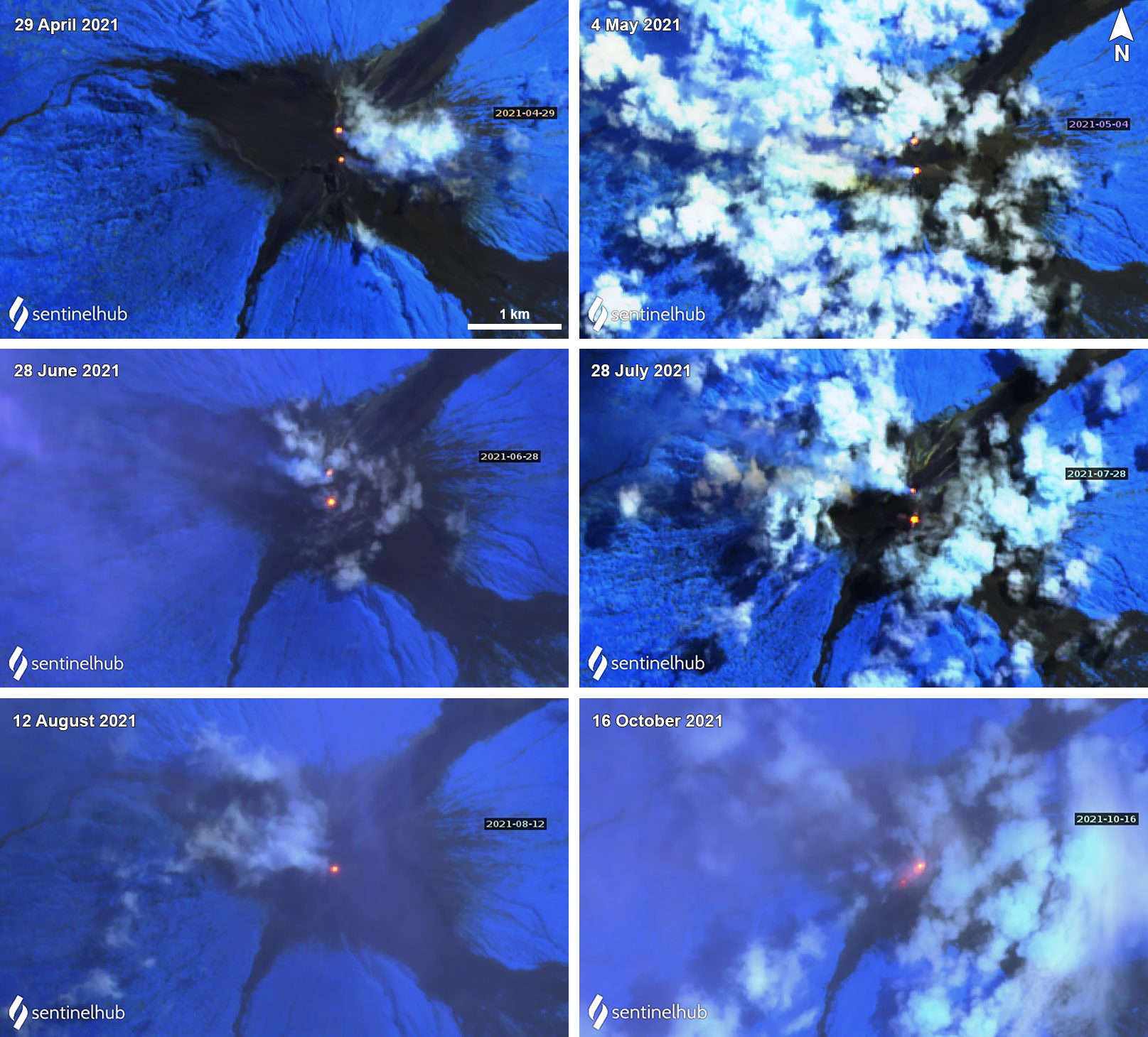 |
Figure 85. Sentinel-2 thermal infrared satellite images show a persistent thermal anomaly (bright yellow-orange) at both of Manam’s summit craters (Main and South) on clear weather days during April through October 2021. Occasional gas-and-steam emissions accompanied the thermal anomalies as seen on 29 April (top left), 4 May (top right), 28 June (middle left), 28 July (middle right), 12 August (bottom left), and 16 October (bottom right) 2021. On 16 October incandescent ejecta was visible rolling down the SW Valley. Sentinel-2 satellite images with “Atmospheric penetration” (bands 12, 11, 8A) rendering. Courtesy of Sentinel Hub Playground. |
Thermal activity during June through October 2021 was frequent and relatively low in power through late August, as recorded by the MIROVA (Middle InfraRed Observation of Volcanic Activity) system. Two brief pulses of stronger anomalies were detected during late August and mid-October (figure 86). A total of 44 thermal alerts were recorded by the MODVOLC thermal algorithm: five in June, five in July, 24 in August, and 10 in October. Two thermal anomalies were identified in Sentinel-2 infrared imagery on clear weather days, one in the Main and one in the South summit craters (figure 85). These were occasionally accompanied by gas-and-steam emissions.
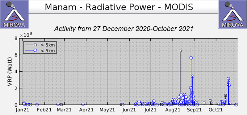 |
Figure 86. Frequent thermal activity at Manam began during early June 2021 and continued through October 2021; the strength of the thermal anomalies increased during late August, as shown on this MIROVA Radiative Power graph. Only a single anomaly was detected during late May. Three stronger anomalies were also recorded during October. Courtesy of MIROVA. |
Geological Summary. The 10-km-wide island of Manam, lying 13 km off the northern coast of mainland Papua New Guinea, is one of the country's most active volcanoes. Four large radial valleys extend from the unvegetated summit of the conical basaltic-andesitic stratovolcano to its lower flanks. These valleys channel lava flows and pyroclastic avalanches that have sometimes reached the coast. Five small satellitic centers are located near the island's shoreline on the northern, southern, and western sides. Two summit craters are present; both are active, although most observed eruptions have originated from the southern crater, concentrating eruptive products during much of the past century into the SE valley. Frequent eruptions, typically of mild-to-moderate scale, have been recorded since 1616. Occasional larger eruptions have produced pyroclastic flows and lava flows that reached flat-lying coastal areas and entered the sea, sometimes impacting populated areas.
Information Contacts: Darwin Volcanic Ash Advisory Centre (VAAC), Bureau of Meteorology, Northern Territory Regional Office, PO Box 40050, Casuarina, NT 0811, Australia (URL: http://www.bom.gov.au/info/vaac/); MIROVA (Middle InfraRed Observation of Volcanic Activity), a collaborative project between the Universities of Turin and Florence (Italy) supported by the Centre for Volcanic Risk of the Italian Civil Protection Department (URL: http://www.mirovaweb.it/); NASA Global Sulfur Dioxide Monitoring Page, Atmospheric Chemistry and Dynamics Laboratory, NASA Goddard Space Flight Center (NASA/GSFC), 8800 Greenbelt Road, Goddard, Maryland, USA (URL: https://so2.gsfc.nasa.gov/); Sentinel Hub Playground (URL: https://www.sentinel-hub.com/explore/sentinel-playground); Robert Baim (URL: https://www.facebook.com/robert.baim.7); Norbert Ngasi (URL: https://www.facebook.com/norbert.ngasi.3).