Report on Copahue (Chile-Argentina) — November 2021

Bulletin of the Global Volcanism Network, vol. 46, no. 11 (November 2021)
Managing Editor: Edward Venzke.
Edited by Kadie L. Bennis.
Copahue (Chile-Argentina) Notable ash plume on 10 August 2021; frequent SO2 emissions and nighttime incandescence
Please cite this report as:
Global Volcanism Program, 2021. Report on Copahue (Chile-Argentina) (Bennis, K.L., and Venzke, E., eds.). Bulletin of the Global Volcanism Network, 46:11. Smithsonian Institution. https://doi.org/10.5479/si.GVP.BGVN202111-357090
Copahue
Chile-Argentina
37.856°S, 71.183°W; summit elev. 2953 m
All times are local (unless otherwise noted)
Copahue, located along the Chile-Argentina border, contains an E summit crater with an acidic 300-m-wide crater lake that has been characterized by intense fumarolic activity. Common activity includes gas-and-ash plumes, crater incandescence, and local ashfall (BGVN 45:12). This report updates activity from November 2020 through October 2021, describing a single ash plume on 10 August 2021 along with dominantly gas-and-steam emissions, volcano-tectonic tremors, and occasional nighttime incandescence. Information primarily comes from the Servicio Nacional de Geología y Minería (SERNAGEOMIN) Observatorio Volcanológico de Los Andes del Sur (OVDAS), the Buenos Aires Volcanic Ash Advisory Center (VAAC), and various satellite data.
Activity during November-December 2020 was relatively low. On 31 October and 1-2 November 2020 pilot reports noted ash plumes, though they were not observed in satellite or webcam data. However, Sentinel-2 natural color satellite imagery from 1 November showed ash deposits on the E flank (figure 63) SERNAGEOMIN reported that 80 volcano-tectonic tremor events were recorded during November. White gas-and-steam emissions were also detected rising 200-300 m above the crater and on 15 November they rose 760 m high; no nighttime incandescence was observed since October. Sulfur dioxide emissions were measured using Differential Optical Absorption Spectroscopy (DOAS) and recorded an average value of 366 ± 129 tons/day (t/d) during November, the highest of which was 578 t/d on 21 November. Similar activity continued in December, with 57 volcano-tectonic tremors and 543 long-period tremors (LP). Gas-and-steam emissions rose 740 m above the crater, based on webcam images. The average SO2 value was 642 ± 85 t/d with a daily maximum value of 1,952 t/d on 14 December.
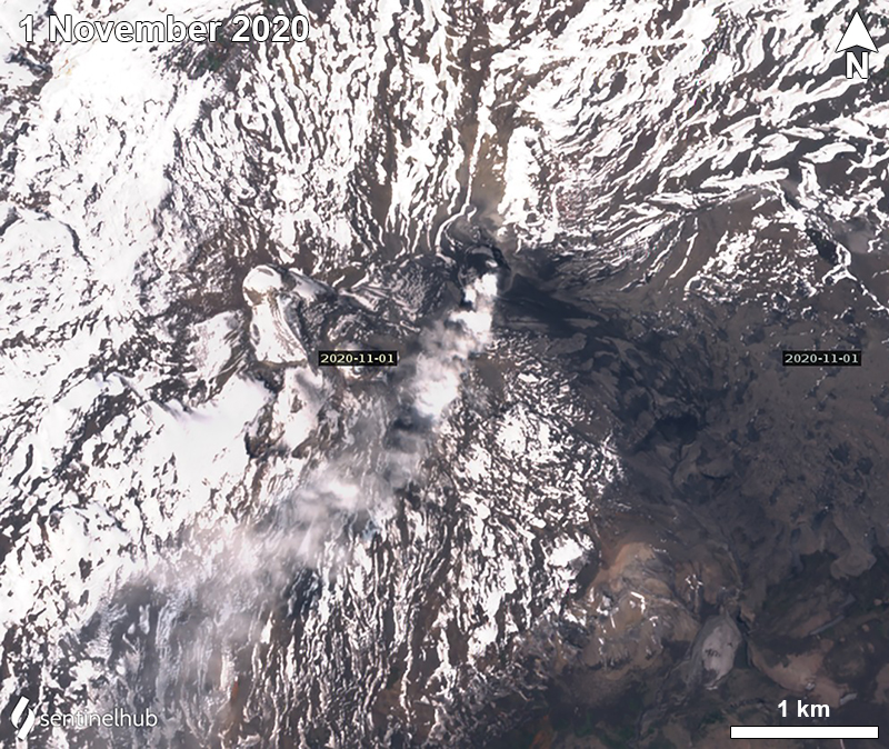 |
Figure 63. Sentinel-2 satellite image showing a strong gas-and-ash plume drifting SW from Copahue on 1 November 2020. Ash deposits (dark gray) were visible on the E flank. Images using “Natural color” rendering (bands 4, 3, 2). Courtesy of Sentinel Hub Playground. |
Similar low activity continued into January 2021, with 116 volcano-tectonic tremors and 4 LP events. Gas-and-steam emissions rose 240 m above the crater, which included SO2 emissions that was an average value of 327 ± 40 t/d; the daily maximum value was 631 t/d on 15 January. During February 198 volcano-tectonic events and 7 LP events were detected. SO2 emissions averaged 254 ± 34 t/d with a daily maximum value of 701 t/d on 4 February.
The number of seismic events during March decreased to 31 volcano-tectonic events and 3 LP events. Gas-and-steam emissions rose 260-320 m above the crater; the average SO2 value was 332 ± 45 t/d with a maximum value of 731 t/d on 11 March. Another 31 volcano-tectonic events and 1 LP event were detected in April. SO2 emissions averaged 430 ± 24 t/d. The highest value was 800 t/d on 14 April.
During May 24 volcano-tectonic events and 5 LP events were detected as degassing plumes rose 200 m above the crater. The average SO2 value was 392 ± 50 t/d with a maximum daily value of 783 t/d on 12 May. Volcano-tectonic tremors continued to decline to 2 LP events during June. During 30 June to 2 July tremor was elevated and the volume of the water in the crater lake decreased significantly. Nighttime incandescence was visible in webcam images, accompanied by gas-and-steam emissions. Similarly, beginning in June and going through November 2021, the Sentinel-2 MODIS Thermal Volcanic Activity graph provided by the MIROVA system identified a small cluster of thermal anomalies in the summit area (figure 64). Weak thermal anomalies in the summit crater were also captured in Sentinel-2 infrared satellite images that were sometimes accompanied by white gas-and-steam plumes (figure 65). Residents reported smelling a gaseous smell. DOAS measurements recorded an average SO2 value of 1,515 ± 761 t/d with a daily maximum value of 14,389 t+/d on 2 July.
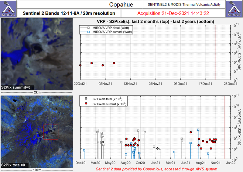 |
Figure 64. Two clusters of thermal anomalies were detected in the summit area of Copahue (red dots) during early August through September 2020 and June through early November 2021 as recorded by the Sentinel-2 MODIS Thermal Volcanic Activity data (bands 12, 11, 8A). Courtesy of MIROVA. |
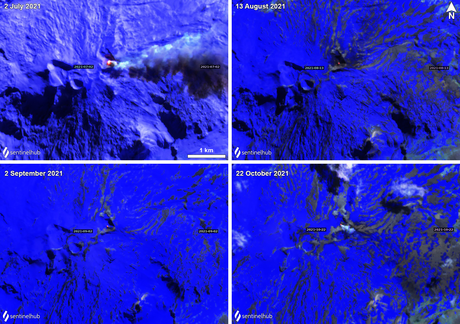 |
Figure 65. Sentinel-2 infrared satellite images showed a small, but persistent, thermal anomaly in the Copahue summit crater on 2 July (top left), 13 August (top right), 2 September (bottom left), and 22 October (bottom right) 2021. These were sometimes accompanied by white gas-and-steam plumes, as seen on 2 July and 22 October 2021. Images using “Atmospheric penetration” rendering (bands 12, 11, 8a). Courtesy of Sentinel Hub Playground. |
By July, both seismicity and degassing increased: 68 volcano-tectonic signals were detected and 2 LP events. Gas-and-steam plumes rose 540 m high and occasional nighttime incandescence was visible from the summit crater. On 2 July minor ash deposits were visible on the SE and ENE flanks. The average SO2 value was 862 ± 103 t/d with a daily maximum value of 2,134 t/d on 14 July.
During August, the number of volcano-tectonic events decreased to 15, though LP events rose to 18. Increased gas-and-ash emissions and periods of crater incandescence were reported during 9-10 August, based on information from SERNAGEOMIN. An ash plume was reported by the Buenos Aires VAAC during 10 August 2021 that rose to 3.4 km altitude and drifted N and NW, which was also confirmed in satellite and webcam images (figure 66). Distinct sulfur dioxide plumes accompanied this activity, identified by the TROPOMI instrument on the Sentinel-5P satellite, which exceeded two Dobson Units (DU) (figure 67). Thermal anomalies were detected intermittently throughout the month, accompanied by an average of 922 ± 146 t/d SO2 emissions, the highest value of which was 3,190 t/d on 24 August.
 |
Figure 66. Photo of an ash plume rising from Copahue on 10 August 2021 at 1400. Courtesy of Valentina Sepulveda. |
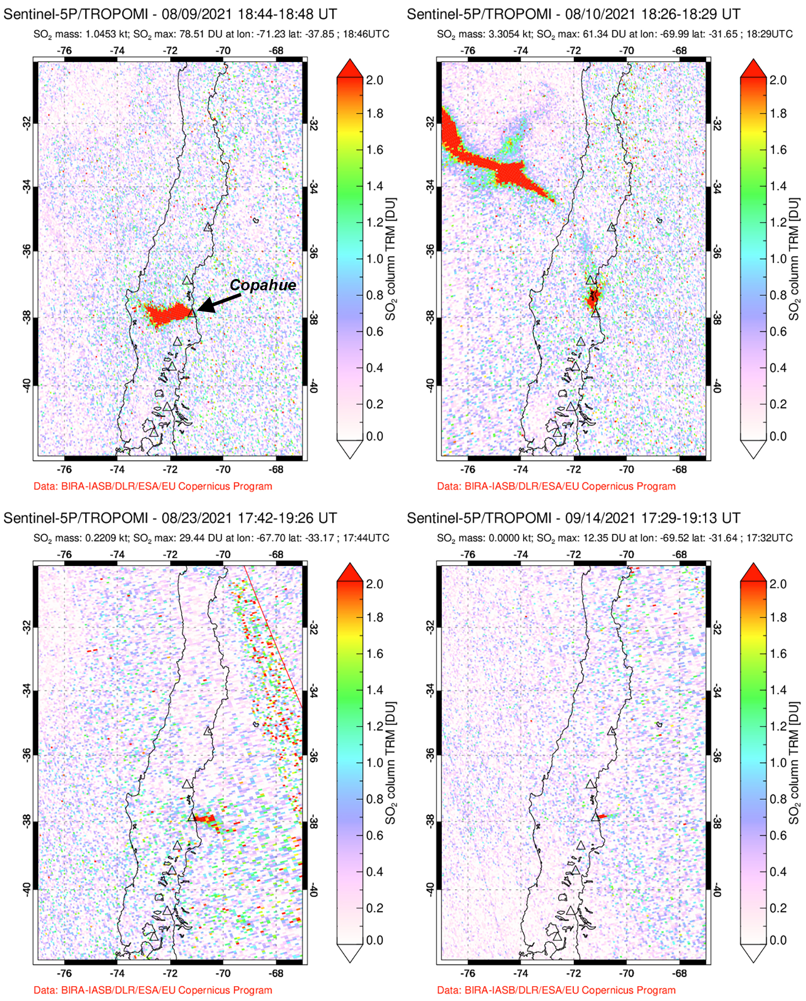 |
Figure 67. Distinct SO2 plumes were recorded at Copahue coincident with the ash plume during 9-10 August 2021. The plume drifted W on 9 August (top left) and strongly NW on 10 August (top right) 2021. Smaller plumes drifted E on 23 August (bottom left) and 14 September (bottom right) 2021. Courtesy of the NASA Global Sulfur Dioxide Monitoring Page. |
Activity during September consisted of 21 volcano-tectonic earthquakes and 2 LP events. Gas-and-steam emissions rose 1.2 km above the crater, accompanied by occasional thermal anomalies. DOAS measurements recorded an average SO2 value of 963 ± 115 t/d with a daily maximum value of 2,571 t/d on 14 September. The number of tremor events declined again during October to 11 volcano-tectonic events and 2 LP events. Gas-and-steam plumes rose 880 m above the crater, accompanied by thermal anomalies.
Geological Summary. Volcán Copahue is an elongated composite cone constructed along the Chile-Argentina border within the 6.5 x 8.5 km wide Trapa-Trapa caldera that formed between 0.6 and 0.4 million years ago near the NW margin of the 20 x 15 km Pliocene Caviahue (Del Agrio) caldera. The eastern summit crater, part of a 2-km-long, ENE-WSW line of nine craters, contains a briny, acidic 300-m-wide crater lake (also referred to as El Agrio or Del Agrio) and displays intense fumarolic activity. Acidic hot springs occur below the eastern outlet of the crater lake, contributing to the acidity of the Río Agrio, and another geothermal zone is located within Caviahue caldera about 7 km NE of the summit. Infrequent mild-to-moderate explosive eruptions have been recorded since the 18th century. Twentieth-century eruptions from the crater lake have ejected pyroclastic rocks and chilled liquid sulfur fragments.
Information Contacts: Servicio Nacional de Geología y Minería (SERNAGEOMIN), Observatorio Volcanológico de Los Andes del Sur (OVDAS), Avda Sta María No. 0104, Santiago, Chile (URL: http://www.sernageomin.cl/); MIROVA (Middle InfraRed Observation of Volcanic Activity), a collaborative project between the Universities of Turin and Florence (Italy) supported by the Centre for Volcanic Risk of the Italian Civil Protection Department (URL: http://www.mirovaweb.it/); Global Sulfur Dioxide Monitoring Page, Atmospheric Chemistry and Dynamics Laboratory, NASA Goddard Space Flight Center (NASA/GSFC), 8800 Greenbelt Road, Goddard, Maryland, USA (URL: https://so2.gsfc.nasa.gov/); Sentinel Hub Playground (URL: https://www.sentinel-hub.com/explore/sentinel-playground); Valentina Sepulveda, Hotel Caviahue, Caviahue, Argentina (URL: https://twitter.com/valecaviahue, Twitter: @valecaviahue).