Report on Sinabung (Indonesia) — January 2022

Bulletin of the Global Volcanism Network, vol. 47, no. 1 (January 2022)
Managing Editor: Edward Venzke.
Edited by Kadie L. Bennis.
Sinabung (Indonesia) Explosions, ash plumes, and block avalanches during June-September 2021
Please cite this report as:
Global Volcanism Program, 2022. Report on Sinabung (Indonesia) (Bennis, K.L., and Venzke, E., eds.). Bulletin of the Global Volcanism Network, 47:1. Smithsonian Institution. https://doi.org/10.5479/si.GVP.BGVN202201-261080
Sinabung
Indonesia
3.17°N, 98.392°E; summit elev. 2460 m
All times are local (unless otherwise noted)
Sinabung in north Sumatra, Indonesia had its first confirmed Holocene eruption during August and September 2010. Dome growth, block avalanches, multiple explosions with ash plumes, and pyroclastic flows are common events that occur. The continuing eruption that began in August 2020 has recently consisted of ash plumes, pyroclastic flows, hundreds of block avalanches, and explosions (BGVN 46:08). This report covers intermittent explosions, ash plumes, and block avalanches from June through September 2021 with information provided by Pusat Vulkanologi dan Mitigasi Bencana Geologi (PVMBG, also known as CVGHM, the Center of Volcanology and Geological Hazard Mitigation), MAGMA Indonesia, and the Darwin Volcanic Ash Advisory Centre (VAAC).
White gas-and-steam emissions dominantly occurred throughout the reporting period; during June, they rose 50-500 m above the summit and drifted E, SE, SW, W, and NW (figure 102). An eruption occurred at 2004 on 3 June, though it was not visually confirmed due to cloud cover. Another event at 2335 on 6 June consisted of ash plumes and pyroclastic flows, though weather again obscured views. A Darwin VAAC notice reported an ash plume visible in satellite images, with the multi-level plume rising to 4.3 km altitude (N), 6.1 km altitude (WNW), 7.3 km altitude (W), and 9.1 km altitude (drifted W and WSW). During 11-13 June block avalanches from the summit lava dome were occasionally recorded, but not visually observed due to weather conditions. Occasional deep volcanic earthquakes occurred through September.
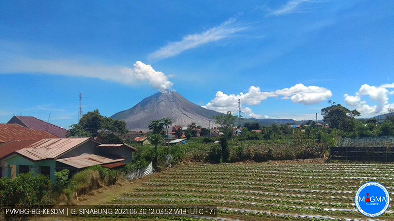 |
Figure 102. Image of a white gas-and-steam plume rising above Sinabung on 30 June 2021. Courtesy of PVMBG and MAGMA Indonesia. |
During July, white gas-and-steam emissions continued to rise 100-500 m above the summit and drift in multiple directions. On 1 July at 1151 a gray plume rose 800 m above the summit and drifted SW and W. An ash plume rose 500 m above the summit and drifted ESE at 0925 on 13 July due to an eruptive or collapse event. Video taken on 13 July showed new vents on the upper W flank that generated gas-and-ash emissions. An eruptive event at 1850 on 19 July produced an ash plume that rose 1 km above the summit and extended ESE; the activity lasted about 11 minutes. A strong explosion on 28 July at 1320 produced an ash plume that rose 4.5 km above the summit and drifted E and S (figure 103) and pyroclastic flows traveled as far as 1 km down the E and SE flanks, prompting PVMBG to raise the Aviation Color Code (ACC) to Red. Ashfall was reported in areas to the E, including the subdistricts of Namanteran, Merdeka, Berastagi, and Simpang Empat; the event lasted for about 12.5 minutes. In addition, a small sulfur dioxide plume that exceeded two Dobson Units (DU) was detected above the volcano, based on data from the TROPOMI instrument on the Sentinel-5P satellite (figure 104).
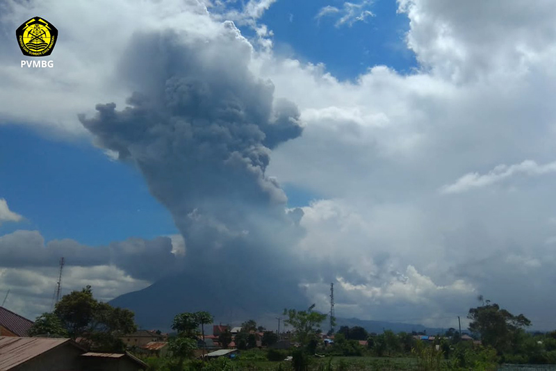 |
Figure 103. Image of the resulting ash plume that rose 4.5 km above Sinabung from the strong explosion on 28 July 2021. Courtesy of PVMBG. |
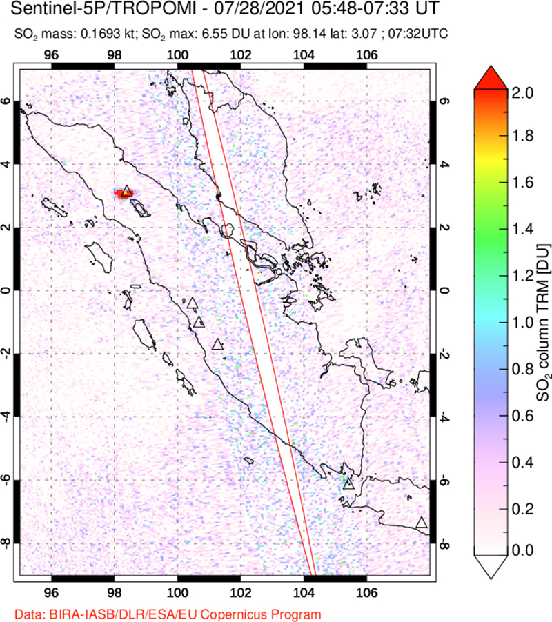 |
Figure 104. The explosion at Sinabung on 28 July 2021 produced a distinct sulfur dioxide plume that exceeded 2 Dobson Units (DU), based on data from the TROPOMI Instrument on the Sentinel-5P satellite. The accompanying ash plume rose 4.5 km above the summit. Courtesy of NASA Global Sulfur Dioxide Monitoring Page. |
Persistent white gas-and-steam emissions rose 50-500 m above the summit and drifted in different directions during August. An avalanche of incandescent material was observed descending 500-700 m to the E and SE during 4-7 August. Another block avalanche descended 700 m on 25 August. Activity decreased during September and October and mostly consisted of white gas-and-steam emissions that rose 50-800 m above the summit and drifted multiple directions. On 23 September infrared Sentinel-2 satellite imagery showed a small thermal anomaly in the summit crater (figure 105).
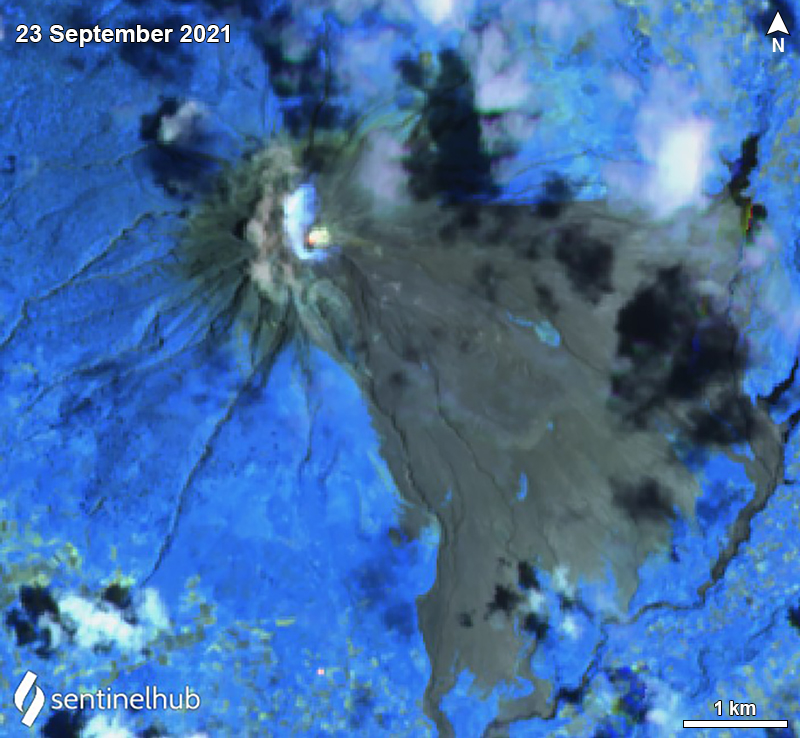 |
Figure 105. A small thermal anomaly at Sinabung was recorded in Sentinel-2 infrared satellite imagery on 23 September 2021. Image uses Atmospheric penetration rendering (bands 12, 11, 8a). Courtesy of Sentinel Hub Playground. |
Geological Summary. Gunung Sinabung is a Pleistocene-to-Holocene stratovolcano with many lava flows on its flanks. The migration of summit vents along a N-S line gives the summit crater complex an elongated form. The youngest crater of this conical andesitic-to-dacitic edifice is at the southern end of the four overlapping summit craters. The youngest deposit is a SE-flank pyroclastic flow 14C dated by Hendrasto et al. (2012) at 740-880 CE. An unconfirmed eruption was noted in 1881, and solfataric activity was seen at the summit and upper flanks in 1912. No confirmed historical eruptions were recorded prior to explosive eruptions during August-September 2010 that produced ash plumes to 5 km above the summit.
Information Contacts: Pusat Vulkanologi dan Mitigasi Bencana Geologi (PVMBG, also known as Indonesian Center for Volcanology and Geological Hazard Mitigation, CVGHM), Jalan Diponegoro 57, Bandung 40122, Indonesia (URL: http://www.vsi.esdm.go.id/); MAGMA Indonesia, Kementerian Energi dan Sumber Daya Mineral (URL: https://magma.esdm.go.id/v1); Darwin Volcanic Ash Advisory Centre (VAAC), Bureau of Meteorology, Northern Territory Regional Office, PO Box 40050, Casuarina, NT 0811, Australia (URL: http://www.bom.gov.au/info/vaac/); NASA Global Sulfur Dioxide Monitoring Page, Atmospheric Chemistry and Dynamics Laboratory, NASA Goddard Space Flight Center (NASA/GSFC), 8800 Greenbelt Road, Goddard, Maryland, USA (URL: https://so2.gsfc.nasa.gov/); Sentinel Hub Playground (URL: https://www.sentinel-hub.com/explore/sentinel-playground); Firdaus Surbakti (URL: https://www.facebook.com/firdaus.surbakti).