Report on San Cristobal (Nicaragua) — February 2022

Bulletin of the Global Volcanism Network, vol. 47, no. 1 (February 2022)
Managing Editor: Benjamin Andrews.
Edited by Kadie L. Bennis.
San Cristobal (Nicaragua) Explosions and ash plumes during December 2021
Please cite this report as:
Global Volcanism Program, 2022. Report on San Cristobal (Nicaragua) (Bennis, K.L., and Andrews, B., eds.). Bulletin of the Global Volcanism Network, 47:1. Smithsonian Institution. https://doi.org/10.5479/si.GVP.BGVN202202-344020
San Cristobal
Nicaragua
12.702°N, 87.004°W; summit elev. 1745 m
All times are local (unless otherwise noted)
San Cristóbal is a volcanic complex located in Nicaragua that consists of five volcanic edifices; the youngest cone, San Cristóbal (also known as El Viejo), is capped by a 500 x 600 m-wide crater. Historical eruptions date back to 1528, with frequent eruptions occurring over the past 50 years. Recent activity has been characterized by thermal anomalies, occasional explosions, and ash plumes (BGVN 46:07). This report updates activity from July through December 2021 using information from the Instituto Nicaragüense de Estudios Territoriales (INETER) and various satellite data.
Activity during July through December 2021 was relatively calm and primarily consisted of gas-and-steam emissions and seismicity. Monitoring data reported by INETER consistently included the average sulfur dioxide levels (tons/day) and the total number of earthquakes per month, a small number of which were volcano-tectonic events (table 8). Tremor remained within 50 and 350 RSAM units.
Table 8. Monthly sulfur dioxide measurements and seismicity reported at San Cristóbal during July-December 2021.
| Month | Average SO2 | Total earthquakes | Volcano-tectonic (VT) earthquakes |
| Jul 2021 | 468 t/d | 113,791 | 11 |
| Aug 2021 | 443 t/d | 106,663 | 9 |
| Sep 2021 | 153 t/d | 105,603 | -- |
| Oct 2021 | 255 t/d | 104,230 | -- |
| Nov 2021 | 326 t/d | -- | -- |
| Dec 2021 | 603 t/d | -- | -- |
Temperature measurements using thermal images showed that gas-and-steam emissions in the crater were 40 °C in August, which was lower than the ~56 °C temperatures measured in July. A 40-m-long by 6-m-wide fracture was observed on the NW wall. Fumaroles persisted in the crater throughout the reporting period (figure 42). Little to no thermal activity was detected near the summit through December; a single weak anomaly was visible in MIROVA data during early October (figure 43). On clear weather days, a weak thermal anomaly was observed in the summit crater in Sentinel-2 infrared satellite imagery (figure 44).
A series of five low-to medium-intensity explosions were recorded between 0522 and 0526 on 15 December, according to INETER. Ash plumes rose 2.5 km above the crater rim and drifted W, resulting in ashfall in La Grecia, Rancherías (8 km NW), and El Viejo (18 km SW). Rocks were ejected 500 m from the vent onto the flanks.
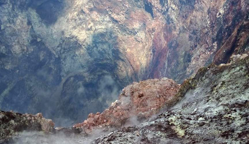 |
Figure 42. Photo of the crater at San Cristóbal taken in October 2021 showing gas-and-steam emissions. Courtesy of INETER (Sismos y Volcanes de Nicaragua. Octubre, 2021). |
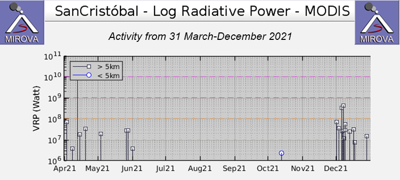 |
Figure 43. Low thermal activity was detected at the summit of San Cristóbal during July through December 2021; this MIROVA (Log Radiative Power) plot indicates only a single weak anomaly in early October. Courtesy of MIROVA. |
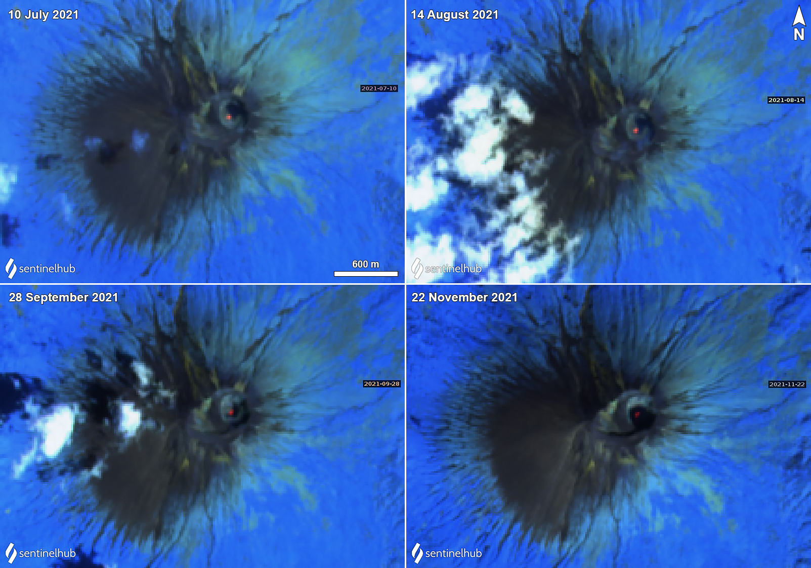 |
Figure 44. Sentinel-2 thermal satellite imagery showing a persistent, weak thermal anomaly (bright yellow-orange) at the summit crater of San Cristóbal on clear weather days on 10 July (top left), 14 August (top right), 28 September (bottom left), and 22 November (bottom right) 2021. Images use “Atmospheric penetration” (bands 12, 11, 8A) rendering. Courtesy of Sentinel Hub Playground. |
Geological Summary. The San Cristóbal volcanic complex, consisting of five principal volcanic edifices, forms the NW end of the Marrabios Range. The symmetrical 1745-m-high youngest cone, named San Cristóbal (also known as El Viejo), is Nicaragua's highest volcano and is capped by a 500 x 600 m wide crater. El Chonco, with several flank lava domes, is located 4 km W of San Cristóbal; it and the eroded Moyotepe volcano, 4 km NE of San Cristóbal, are of Pleistocene age. Volcán Casita, containing an elongated summit crater, lies immediately east of San Cristóbal and was the site of a catastrophic landslide and lahar in 1998. The Plio-Pleistocene La Pelona caldera is located at the eastern end of the complex. Historical eruptions from San Cristóbal, consisting of small-to-moderate explosive activity, have been reported since the 16th century. Some other 16th-century eruptions attributed to Casita volcano are uncertain and may pertain to other Marrabios Range volcanoes.
Information Contacts: Instituto Nicaragüense de Estudios Territoriales (INETER), Apartado Postal 2110, Managua, Nicaragua (URL: http://www.ineter.gob.ni/); MIROVA (Middle InfraRed Observation of Volcanic Activity), a collaborative project between the Universities of Turin and Florence (Italy) supported by the Centre for Volcanic Risk of the Italian Civil Protection Department (URL: http://www.mirovaweb.it/); Sentinel Hub Playground (URL: https://www.sentinel-hub.com/explore/sentinel-playground).