Report on Reventador (Ecuador) — March 2022

Bulletin of the Global Volcanism Network, vol. 47, no. 3 (March 2022)
Managing Editor: Edward Venzke.
Edited by Kadie L. Bennis.
Reventador (Ecuador) Daily explosions and ash plumes with incandescent block avalanches during August 2021-January 2022
Please cite this report as:
Global Volcanism Program, 2022. Report on Reventador (Ecuador) (Bennis, K.L., and Venzke, E., eds.). Bulletin of the Global Volcanism Network, 47:3. Smithsonian Institution. https://doi.org/10.5479/si.GVP.BGVN202203-352010
Reventador
Ecuador
0.077°S, 77.656°W; summit elev. 3562 m
All times are local (unless otherwise noted)
Volcán El Reventador is located 100 km E of the main axis of active volcanoes in Ecuador and has had eruptions recorded since the 16th century, characterized by explosive events and lava flows. The most recent eruption began in 2008 and has recently consisted of ash explosions, lava flows, and block avalanches (BGVN 46:08). This report describes daily explosions, ash plumes, incandescent block avalanches, lava flows, and occasional pyroclastic flows and lahars during August 2021 through January 2022, based on daily reports from Ecuador's Instituto Geofisico (IG-EPN), the Washington Volcano Ash Advisory Center (VAAC), and infrared satellite data.
During August 2021 to January 2022, IG-EPN reported daily explosions, gas-and-steam and ash plumes, and frequent crater incandescence, often accompanied by incandescent block avalanches and lava flows. The highest average number of explosions per day was 74 in August, followed by 68 in October (table 14). During January 2022, the average number of daily explosions had declined to 32. Ash plumes rose to a maximum height of 1.7 km above the crater during 2-3 September and 10 October. At night and early morning, frequent crater incandescence was visible, occasionally accompanied by lava flows generally on the S and NE flanks and incandescent block avalanches traveling as far as 800 m from the summit.
Table 14. Monthly summary of explosions and plume heights recorded at Reventador from August 2021 through January 2022. Data courtesy of IG-EPN (August 2021 to January 2022 daily reports).
| Month | Average number of explosions per day | Max plume height above the crater (km) |
| Aug 2021 | 74 | 1.6 |
| Sep 2021 | 64 | 1.7 |
| Oct 2021 | 68 | 1.7 |
| Nov 2021 | 57 | 1.4 |
| Dec 2021 | 49 | 1.3 |
| Jan 2022 | 32 | 1.4 |
Summit crater activity was relatively similar during August and September 2021. There were 34-100 daily explosive events during these two months, which generated gas-and-steam and ash plumes that rose 300-1,700 m above the crater that drifted in multiple directions. At night, crater incandescence was frequently visible and incandescent block avalanches intermittently traveled 300-800 m down all the flanks, but primarily the NE and SE flanks. A lava flow was observed descending the S and NE flank during 2-3 August. On 12 August an ash plume rose as high as 1.6 km above the crater (figure 149). An active lava flow was detected on the NE flank during the afternoon of 12 August through the late morning of 13 August. During 2-3 September ash plumes varied from 1.4-1.7 km above the crater and drifted SW and W (figure 149). Incandescent blocks during 29-30 November were observed rolling down the E flank for about 800 m and accompanied crater incandescence.
 |
Figure 149. Webcam images of gas-and-ash plumes rising as high as 1.6 km above the crater on 12 August 2021 (left) and 1.7 km above the crater and drifting W and SW on 3 September 2021 (right). Courtesy of IG-EPN (INFORME DIARIO DEL VOLCAN REVENTADOR No. 2021-225, 12 de agosto de 2021 and INFORME DIARIO DEL VOLCAN REVENTADOR No. 2021-247, 03 de septiembre de 2021). |
During October and November, daily explosions continued, with 8-105 per day and resulting gas-and-ash plumes that rose 100-1,700 m above the crater and drifted in different directions. Nighttime crater incandescence was frequently visible, accompanied by occasional block avalanches that descended 300-800 m down all the flanks, especially the S and SE flanks. According to Washington VAAC reports, ash emissions rose as high as 1.7 km above the summit and drifted NW and W on 2 and 8-10 October 2021 (figure 150). A pyroclastic flow was captured descending the S flank at 0617 on 25 October 2021 (figure 151). Ashfall was reported in Gonzalo Pizarro on 27 October. On 7 November an ash plume rose 1.2 km above the summit and drifted W and SW (figure 150). During 8-9 November ash emissions rose as high as 1.4 km above the summit and drifted SW and N, according to a Washington VAAC notice. Some light ashfall was reported during the morning of 12 and 14 November in San Luis del El Chaco. A lava flow was detected on the NE flank advancing slowly during 14-16 November.
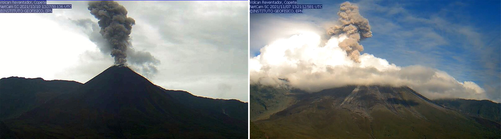 |
Figure 150. Webcam image of a gas-and-ash plume that rose 1.7 km above the summit on 10 October 2021 (left) and 1.2 km above the summit on 7 November 2021 (right). Courtesy of IG-EPN (INFORME DIARIO DEL VOLCAN REVENTADOR No. 2021-277, 10 de octubre de 2021 and INFORME DIARIO DEL VOLCAN REVENTADOR No. 2021-312, 07 de noviembre de 2021). |
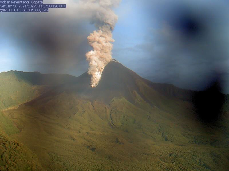 |
Figure 151. Webcam image of a pyroclastic flow descending the S flank of Reventador at 0617 on 25 October 2021. Courtesy of IG-EPN (INFORME DIARIO DEL VOLCAN REVENTADOR No. 2021-299, 25 de octubre de 2021). |
Activity persisted during December and January 2022, characterized by 7-103 daily explosions, frequent ash plumes, and crater incandescence; however, weather and clouds in January often prevented clear views of the summit. Ash plumes rose 500-1,400 m above the summit and drifted in different directions, especially W, SW, and NW. Nighttime crater incandescence was occasionally accompanied by incandescent blocks that descended 300-800 m on all sides of the volcano, including the S, SE, and NE flanks. On 1, 2, and 15 December ash plumes rose 1.3 km above the summit and drifted W and SW, respectively. An active lava flow was reported traveling down the N flank during 1-2 and 25-26 December. During the night of 13 December and during 16-19 and 22-27 December, a lava flow descended the NE flank, based on data from surveillance cameras (figure 152). A lava flow on the E flank was reported during 14-15 and 23-24 January. On 4, 29, and 30 January ash plumes rose 1.4 km above the summit and drifted S and SE.
 |
Figure 152. Thermal image of an active lava flow descending the NE flank of Reventador at 0720 on 25 January. Courtesy of IG-EPN (INFORME DIARIO DEL VOLCAN REVENTADOR No. 2021-025, 25 de enero de 2022). |
MIROVA (Middle InfraRed Observation of Volcanic Activity) analysis of MODIS satellite data showed intermittent thermal anomalies of varying intensity during April 2021 through January 2021, which reflected the active lava flows and incandescent block avalanches occurring throughout that time (figure 153). In comparison, the MODVOLC thermal algorithm 37 thermal anomalies were detected by the MODVOLC thermal algorithm on 4 and 20 August, 5, 14, and 28 September, 1, 2, and 3 October, 4, 17, 22, 24, and 29 November, 31 December 2021, and 2, 7, and 9 January 2022. Some thermal anomalies and incandescent avalanches on the NE flank were visible in Sentinel-2 infrared satellite imagery, though clouds often obscured the view of the summit (figure 154).
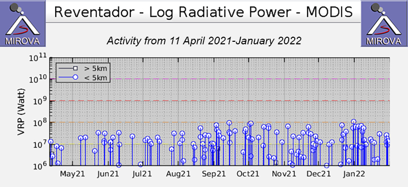 |
Figure 153. Frequent thermal activity was detected at Reventador at varying levels during August 2021 through January 2022, based on this MIROVA graph (Log Radiative Power). Courtesy of MIROVA. |
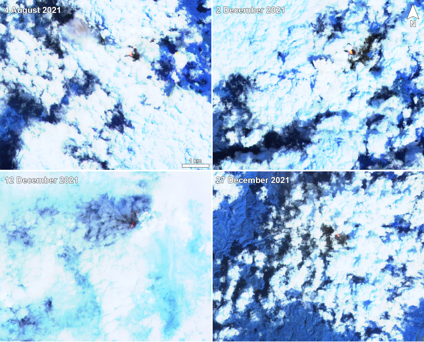 |
Figure 154. Sentinel-2 infrared satellite images of Reventador on 4 August (top left), 2 December (top right), 12 December (bottom left), and 27 December (bottom right) 2021 showing a strong thermal anomaly at the summit crater. On 12 December an incandescent block avalanche could be seen through the clouds descending the NE flank. Images with “Atmospheric penetration” (bands 12, 11, 8A) rendering. Courtesy of Sentinel Hub Playground. |
Geological Summary. Volcán El Reventador is the most frequently active of a chain of Ecuadorian volcanoes in the Cordillera Real, well east of the principal volcanic axis. The forested, dominantly andesitic stratovolcano has 4-km-wide avalanche scarp open to the E formed by edifice collapse. A young, unvegetated, cone rises from the amphitheater floor to a height comparable to the rim. It has been the source of numerous lava flows as well as explosive eruptions visible from Quito, about 90 km ESE. Frequent lahars in this region of heavy rainfall have left extensive deposits on the scarp slope. The largest recorded eruption took place in 2002, producing a 17-km-high eruption column, pyroclastic flows that traveled up to 8 km, and lava flows from summit and flank vents.
Information Contacts: Instituto Geofísico, Escuela Politécnica Nacional (IG-EPN), Casilla 17-01-2759, Quito, Ecuador (URL: http://www.igepn.edu.ec/); Washington Volcanic Ash Advisory Center (VAAC), Satellite Analysis Branch (SAB), NOAA/NESDIS OSPO, NOAA Science Center Room 401, 5200 Auth Rd, Camp Springs, MD 20746, USA (URL: www.ospo.noaa.gov/Products/atmosphere/vaac, archive at: http://www.ssd.noaa.gov/VAAC/archive.html); MIROVA (Middle InfraRed Observation of Volcanic Activity), a collaborative project between the Universities of Turin and Florence (Italy) supported by the Centre for Volcanic Risk of the Italian Civil Protection Department (URL: http://www.mirovaweb.it/); Hawai'i Institute of Geophysics and Planetology (HIGP) - MODVOLC Thermal Alerts System, School of Ocean and Earth Science and Technology (SOEST), Univ. of Hawai'i, 2525 Correa Road, Honolulu, HI 96822, USA (URL: http://modis.higp.hawaii.edu/); Sentinel Hub Playground (URL: https://www.sentinel-hub.com/explore/sentinel-playground).