Report on Santa Maria (Guatemala) — April 2022

Bulletin of the Global Volcanism Network, vol. 47, no. 4 (April 2022)
Managing Editor: Benjamin Andrews.
Edited by Kadie L. Bennis.
Santa Maria (Guatemala) Frequent explosions, ash plumes, and block avalanches during August 2021-January 2022
Please cite this report as:
Global Volcanism Program, 2022. Report on Santa Maria (Guatemala) (Bennis, K.L., and Andrews, B., eds.). Bulletin of the Global Volcanism Network, 47:4. Smithsonian Institution. https://doi.org/10.5479/si.GVP.BGVN202204-342030
Santa Maria
Guatemala
14.757°N, 91.552°W; summit elev. 3745 m
All times are local (unless otherwise noted)
The Santiaguito lava-dome complex of Guatemala's Santa María volcano has been actively erupting since 1922. It formed within a large crater on the SW flank which was created during the 1902 eruption. Ash explosions, pyroclastic flows, and lava flows have emerged from Caliente, the youngest of the four vents in the complex, for more than 40 years. The Caliente vent has an elevation of about 2.5 km, and the summit of Santa Maria is about 3.7 km elevation. A lava dome that appeared within the summit crater of Caliente in October 2016 has continued to grow, producing frequent block avalanches down the flanks. Daily explosions with ash plumes and block avalanches continued during this report period of August 2021-January 2022, with information primarily from Guatemala's INSIVUMEH (Instituto Nacional de Sismologia, Vulcanologia, Meterologia e Hidrologia).
Activity during August consisted of gas-and-steam emissions rising to 3-3.3 km altitude and drifting SW, weak to moderate explosions that produced gray ash plumes to 2.8-3.5 km altitude that drifted mainly W and SW, and constant weak to moderate block-and-ash avalanches down the W, SW, and S flanks, some of which reached the base of the lava dome. As a result of the avalanches, some fine ash particles were occasionally detected around the volcano. Crater incandescence was frequently observed. On 4 August an explosion generated an ash plume that rose to 2.8 km altitude and drifted W and SW for 6 km, followed by fine ashfall in the villages of Loma Linda Palajunoj, San Marcos Palajunoj, and farms in the surrounding area. Incandescent block avalanches traveled 600 m down the W flank on 8, 18, and 23 August. Explosions on 14 and 24 August produced ash plumes that rose to 2.8 km altitude and drifted as far as 8 km S and SW, resulting in ashfall in the villages of Las Marías and Calaguache on the 14th and in San Marcos and Loma Linda Palajunoj, and farms in the area on the 24th. Due to heavy rains on 23 August, lahars were detected in the Cabello de Ángel, located S of the volcano, according to CONRED.
Similar explosions and ash plumes continued in September. Gas-and-steam plumes rose to 2.7-3.5 km altitude and drifted generally W and SW from the Caliente vent. Weak to moderate explosions produced ash plumes that rose to 3-3.4 km altitude and drifted primarily to the W and SW. Incandescent block-and-ash avalanches descended mainly the W, SW, and S flanks, which sometimes reached the base of the dome and continued to generate fine ashfall surrounding the volcano. Heavy rainfall on 1 September generated lahars in the Cabello de Ángel river south of the volcano. The river carried blocks up to 1 m in diameter, fine sediments, and tree trunks and branches. On 17 September the smell of sulfur was reported from several communities up to 7 km S of the lava dome as block avalanches continued down the W flank of the Caliente dome. An explosion on 18 September produced an ash plume that rose to 3 km altitude that dispersed W as far as 10 km, and resulted in ashfall in San Marcos Palajunoj, Loma Linda Palajunoj, and farms in the area. Strong rainfall resulted in lahars descending the San Isidro and Cabello de Ángel rivers, moving blocks 30 cm to 1 m in diameter and material that was deposited on the upper part of the volcano.
Explosions and ash plumes persisted in October. Gas-and-steam emissions rose 3-3.5 km altitude and gray and white eruption columns rose to 3-3.4 km altitude that drifted generally S and SW. Block avalanches descended the W, SW, and S flanks of the Caliente dome, commonly generating fine ashfall around the volcano. On 3 October an explosion generated an ash plume that rose to 2.8-3 km altitude and drifted S and SW as far as 10 km, resulting in ashfall in San Marcos Palajunoj, Loma Linda Palajunoj, and farms in the area. Lahars were detected in the El Tambor river on 19 October, located SSW of the volcano that carried blocks up to 3 m in diameter, fine sediment, and tree trunks and branches.
During November, weak to moderate block avalanches mainly affected the SW, W, NW, and S flanks of the Caliente dome. Weak to moderate explosions produced white and gray ash plumes that rose to 3.5 km altitude and drifted generally SW and W, sometimes resulting in ashfall near the volcano. Constant incandescence was observed above the lava dome in addition to gas-and-steam emissions rising to 3 km altitude (figure 129). On 2 November an explosion produced an ash plume that rose to 3.4 km altitude and drifted SW, causing ashfall in the Monte Claro area. On 20 November an explosion generated an ash plume that rose to 3.4 km altitude and drifted W and SW and ashfall was reported in Monte Claro. Explosions during 28 and 29 November ejected ash plumes to 3.3-3.4 km altitude that extended 10 km to the W, NW, SW, and S, causing ashfall in the villages of San Marcos Palajunoj and Loma Linda Palajunoj.
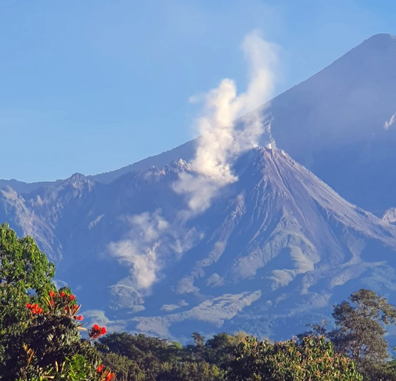 |
Figure 129. Photo of white gas-and-steam emissions rising above the Caliente dome of Santa María at 0845 on 24 November 2021. Courtesy of CONRED (Informative Bulletin No. 532-2021). |
Activity consisting of weak degassing over the Caliente dome rising 150-800 m above the vent and weak to moderate avalanches persisted during December. Some of the avalanches were preceded by explosions; effusive activity continued to build up the W flank and the lava dome. Intermittent ash plumes rose to altitudes of 3-3.4 km and extended generally to the S, SW, and W. On 3 December an ash plume rose to 3 km altitude and drifted NW and W as far as 10 km and, as a result, ashfall was reported in San Marcos Palajunoj and Loma Linda. An explosion on 13 December produced an ash plume that dispersed to the W and SW as far as 15 km and ashfall was reported in the villages of San Marcos and Loma Linda Palajunoj. Ash was also reported in these villages on 17, 18, 28, and 31 December. During the night and early morning of 16-17 December intense incandescence was observed on the W and SW edge of the Caliente dome, accompanied by block avalanches descending the W, SW, and S flanks. On 29 December an explosion expelled an ash plume to 3.2 km altitude that drifted for 10 km to the W and NW, followed by fine ashfall in Loma Linda Palajunoj, San Marcos Palajunoj, and Llanos del Pinal.
White and gray gas-and-steam emissions rose 100-600 m above the crater that generally expanded to the W and SW and weak-to-moderate explosions ejecting ash plumes to 2.8-3.4 km altitude persisted during January 2022. At night and during the early morning, persistent and strong incandescence was observed from the Caliente dome. Frequent moderate-to-strong block avalanches continued descend mostly the W, SW, and S flanks, and weaker ones down the NE, SE, and E flanks, some of which reached the base of the dome. During 2-3, 8, 12-14, 17-18, 22-23 January ash plumes rose to 3.1-3.3 km altitude that drifted W and NW for 10-15 km, causing ashfall in the villages of Loma Linda Palajunoj, San Marcos Palajunoj, and Llanos del Pinal. On 7, 17, 22 January two lava flows were reported on the W and SW flanks with lengths of 500 and 700 m, respectively. In addition, explosions generated an ash plume that rose to 3.2 km altitude and drifted W and NW for 10 km, causing ashfall in the villages of Loma Linda Palajunoj, San Marcos Palajunoj, and Llanos del Pinal. On 29 January moderate to strong ashfall was reported in Loma Linda Palajunoj, San Marcos Palajunoj, El Palmar, and Quetzaltenango. From the early morning on 30 January through 1800 on 31 January, 10 pyroclastic flows were detected by seismic sensors and surveillance cameras. Gas-and-steam emissions persisted over the Caliente dome as high as 600 m.
Intermittent low-level thermal activity was recorded during August through October 2021, as reported by MIROVA (figure 130). Beginning in November, the frequency and power of the anomalies gradually increased through January 2022. According to MODVOLC infrared satellite data from NASA’s MODIS instrument, a total of 21 hotspots were detected over the Caliente vent on 17, 19, 23, 26, and 30 December and 2, 12, 18, 19, 20, 24, and 29 January. On clear weather days, Sentinel-2 infrared satellite imagery showed a small thermal anomaly over the Caliente vent; on 2 January 2022 a linear anomaly was visible on the W flank, which was likely the result of incandescent blocks or a pyroclastic flow (figure 131).
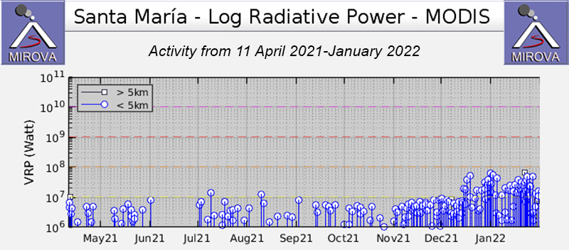 |
Figure 130. Low-level intermittent thermal activity was detected at Santa María during August through October 2021, based on data from MIROVA (Log Radiative Power). Anomalies were followed by an increase in both frequency and power beginning in November and continuing through January 2022. Courtesy of MIROVA. |
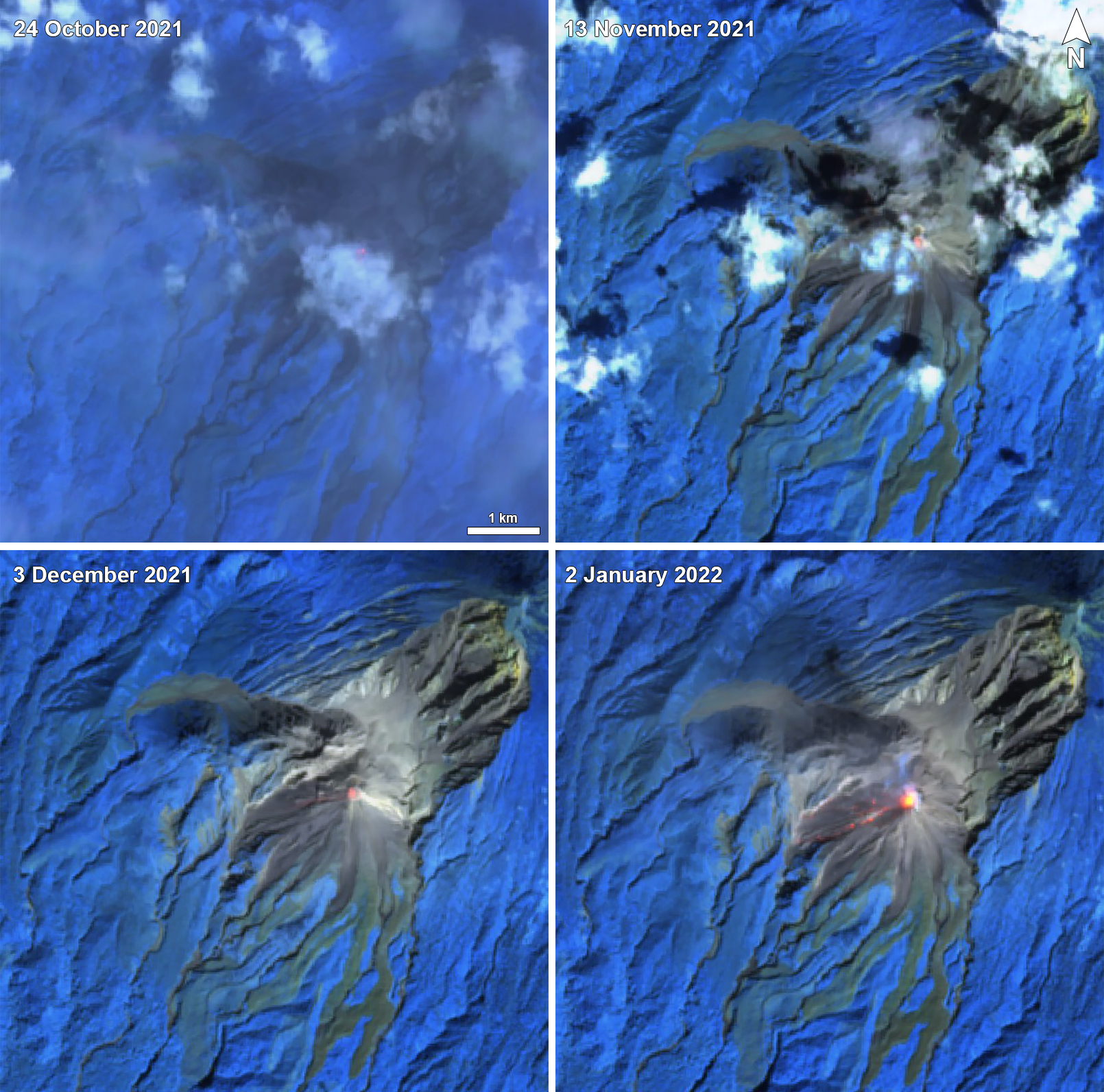 |
Figure 131. Sentinel-2 infrared satellite imagery showed a small thermal anomaly over the Caliente vent of Santa María on 24 October (top left), 13 November (top right), 3 December (bottom left) 2021, and 2 January (bottom right) 2022. A linear thermal anomaly was visible on the W flank originating from the Caliente vent on 2 January, which was likely due to either incandescent blocks or a pyroclastic flow. Images use Atmospheric penetration rendering (bands 12, 11, 8a). Courtesy of Sentinel Hub Playground. |
Geological Summary. Symmetrical, forest-covered Santa María volcano is part of a chain of large stratovolcanoes that rise above the Pacific coastal plain of Guatemala. The sharp-topped, conical profile is cut on the SW flank by a 1.5-km-wide crater. The oval-shaped crater extends from just below the summit to the lower flank, and was formed during a catastrophic eruption in 1902. The renowned Plinian eruption of 1902 that devastated much of SW Guatemala followed a long repose period after construction of the large basaltic andesite stratovolcano. The massive dacitic Santiaguito lava-dome complex has been growing at the base of the 1902 crater since 1922. Compound dome growth at Santiaguito has occurred episodically from four vents, with activity progressing E towards the most recent, Caliente. Dome growth has been accompanied by almost continuous minor explosions, with periodic lava extrusion, larger explosions, pyroclastic flows, and lahars.
Information Contacts: Instituto Nacional de Sismologia, Vulcanologia, Meteorologia e Hydrologia (INSIVUMEH), Unit of Volcanology, Geologic Department of Investigation and Services, 7a Av. 14-57, Zona 13, Guatemala City, Guatemala (URL: http://www.insivumeh.gob.gt/); CONRED, Coordinadora Nacional para la reduccion de desastres (URL: https://conred.gob.gt/); MIROVA (Middle InfraRed Observation of Volcanic Activity), a collaborative project between the Universities of Turin and Florence (Italy) supported by the Centre for Volcanic Risk of the Italian Civil Protection Department (URL: http://www.mirovaweb.it/); Hawai'i Institute of Geophysics and Planetology (HIGP) - MODVOLC Thermal Alerts System, School of Ocean and Earth Science and Technology (SOEST), Univ. of Hawai'i, 2525 Correa Road, Honolulu, HI 96822, USA (URL: http://modis.higp.hawaii.edu/); Sentinel Hub Playground (URL: https://www.sentinel-hub.com/explore/sentinel-playground).