Report on Fuego (Guatemala) — May 2022

Bulletin of the Global Volcanism Network, vol. 47, no. 5 (May 2022)
Managing Editor: Edward Venzke.
Edited by Kadie L. Bennis.
Fuego (Guatemala) Frequent explosions with ash plumes, and occasional lava flows, during December 2021-March 2022
Please cite this report as:
Global Volcanism Program, 2022. Report on Fuego (Guatemala) (Bennis, K.L., and Venzke, E., eds.). Bulletin of the Global Volcanism Network, 47:5. Smithsonian Institution. https://doi.org/10.5479/si.GVP.BGVN202205-342090
Fuego
Guatemala
14.4748°N, 90.8806°W; summit elev. 3799 m
All times are local (unless otherwise noted)
Fuego has been vigorously erupting since January 2002 with recorded eruptions dating back to 1531. Eruption activity has included major ashfalls, pyroclastic flows, lava flows, and lahars. Frequent explosions with ash emissions, block avalanches, and lava flows have persisted since 2018. This report covers similar activity during December 2021 through March 2022 based on daily reports from the Instituto Nacional de Sismologia, Vulcanología, Meteorología e Hidrologia (INSIVUMEH) and various satellite data.
The frequent explosions that occurred during December 2021 through March 2022 generated shock waves and vibrations that rattled roofs and windows in communities near the volcano. Ash plumes rose to 4.2-5.2 km altitude each day and drifted in different directions, though dominantly W and SW. The explosions also produced incandescent block avalanches that descended several flank drainages (barrancas), with some of the blocks reaching the edge of vegetation near the bottom. The Ceniza and Trinidad drainages were primarily affected by strong block avalanches throughout the reporting period, though all drainages were affected, including Las Lajas, El Jute, Santa Teresa, Taniluyá, Honda, and Seca. Nighttime incandescence and ejecta could often be seen rising 50-400 m above the summit. Ashfall was frequently reported in nearby communities (table 25). Active lava flows were reported in the Ceniza each month and Ceniza and Santa Teresa drainages during March. The MIROVA graph showed that frequent and moderate thermal activity was consistent throughout the reporting period, with a pulse in activity during February-March (figure 158). A total of 90 MODVOLC thermal alerts were issued. Sentinel-2 infrared satellite data showed thermal anomalies inside the summit crater, as well as the incandescent block avalanches descending primarily the S and SW flanks five to six times each month (figure 159).
Table 25. Activity at Fuego during December 2021-March 2022 included multiple explosions every hour that produced ash emissions that rose as high as 5.2 km altitude and drifted generally W and SW as far as 50 km from the volcano. Incandescent pulses often sent ejecta hundreds of meters high, and ashfall was reported in many communities around the volcano. Data from INSIVUMEH daily reports.
| Month | Explosions per hour | Ash plume altitude (km) | Ash plume distance (km) and direction | Incandescent pulse height (m) | Communities reporting ashfall |
| Dec 2021 | 3-13 | 4.2-5.2 | 10-40 W, SW, NW, S, SE, E, N | 100-300 | Panimaché I and II, Morelia, Santa Sofía, El Porvenir, San Pedro Yepocapa, Palo Verde, Sangre de Cristo, Yucales, San Andrés Osuna, La Rochela, Ceylán, Quisache, El Campamento, La Soledad, and Acatenango |
| Jan 2022 | 5-13 | 4.3-4.8 | 10-50 W, SW, NW, S, E, NE, N | 100-400 | Panimaché I and II, Morelia, Santa Sofía, El Porvenir, Palo Verde, Yucales, Sangre de Cristo, San Pedro Yepocapa, La Rochela, Alotenango, Ciudad Vieja, Antigua Guatemala, Ceilán, San Andrés Osuna, and Reunión |
| Feb 2022 | 2-14 | 4.3-4.8 | 8-30 W, SW, S, NE, E | 50-300 | Panimaché I and II, Morelia, Santa Sofia, El Porvenir, San Pedro Yepocapa, Sangre de Cristo, Finca Palo Verde, La Rochela, Ceilán, San Andrés Osuna, Alotenango, Ciudad Vieja, San Miguel Dueñas, Antigua Guatemala, and Yucales |
| Mar 2022 | 1-11 | 4.3-5 | 8-40 W, SW, S, SE, N, NW, E, NE | 100-400 | Panimaché I and II, Morelia, Santa Sofía, La Rochela, Ceilán, San Andrés Osuna, El Porvenir, Palo Verde, Yucales, Sangre de Cristo, Yepocapa, La Soledad, San Antonio, Nejapa, Acatenango, and Patzicía |
 |
Figure 158. Frequent moderate-to-strong levels of thermal activity at Fuego were shown in the MIROVA graph (Log Radiative Power) during April 2021 through March 2022. Both the frequency and intensity of these anomalies increased during February-March 2022, which sharply declined in power through March 2022. Courtesy of MIROVA. |
 |
Figure 159. Frequent incandescent block avalanches descended multiple drainages at Fuego during December 2021 through March 2022, as shown in these Sentinel-2 infrared satellite images on 5 December 2021 (top left), 14 January 2022 (top right), 18 February 2022 (bottom left), and 10 March 2022 (bottom right). Ash emissions also occurred daily and are seen on 14 January and 10 March. Avalanches dominantly affected the S and SW flanks. The ash plume visible in the image on 10 March drifted generally W. Images use Atmospheric penetration rendering (bands 12, 11, 8a). Courtesy of Sentinel Hub Playground. |
During December 2021 explosions occurred at a rate of 3-13 per hour, producing ash plumes that rose to 4.2-5.2 km altitude, and drifted in multiple directions. Ash was reported extending as far as 40 km from the volcano on 11 and 16 December. Shock waves frequently rattled windows and roofs around the volcano. Pulses of incandescent ejecta rose 100-300 m high. A total of 22 MODVOLC thermal alerts were recorded on 11 days during the month: 1, 2, 6, 7, 10, 18, 23, 26, 27, 29, and 30 December. Ashfall was reported on 15 days during the month, dominantly affecting Panimaché I and II (8 km SW), Morelia (9 km SW), Santa Sofía (12 km SW), El Porvenir (8 km ENE), San Pedro Yepocapa (8 km NW), Palo Verde, and Sangre de Cristo. Ashfall was detected in Yucales on 17 December, in San Andrés Osuna and La Rochela on 21 December, in San Andrés Osuna, La Rochela, and Ceylán on 23-24 December, and in Quisache, El Campamento, La Soledad, and Acatenango on 29 December. Moderate block avalanches constantly descended the Ceniza (SSW) drainage, sometimes reaching the edge of vegetation. Avalanches also affected the Taniluyá (SW), Trinidad (S), Santa Teresa, Las Lajas (SE), El Jute, Seca (W), and Honda drainages.
Daily explosions ranged between 5 and 13 per hour during January 2022, which generated ash plumes that rose to 4.3-4.8 km altitude and drifted dominantly W and SW. Ash extended as far as 50 km W on 6 January. Intermittent pulses of incandescent ejecta rose 100-400 m high. A total of 17 MODVOLC thermal alerts were recorded on 11 days during the month: 12, 15, 19, 21, 23, 24, 26, 28, 29, 30, and 31 January. Ashfall was reported on 20 days, primarily affecting Panimaché I and II, Morelia, Santa Sofía, El Porvenir, Palo Verde, Sangre de Cristo. Ashfall was detected in Yucales on 2 and 7 January, La Rochela on 10, 15, and 20 January, San Pedro Yepocapa on 12 January, Alotenango, Ciudad Vieja, and Antigua Guatemala on 16 January, Ceilán and San Andrés Osuna on 18 January, Alotenago and Reunión on 22 January, and La Rochela, Ceilán, and San Andrés Osuna on 31 January. Frequent block avalanches descended the Ceniza, Taniluyá, and Trinidad, and Seca drainages more frequently, and weaker down the Santa Teresa, Las Lajas, and Honda drainages throughout the month. Sometimes the avalanches reached vegetation. On 26 January a 50-m-long lava flow was observed descending the Ceniza drainage, which remained active through the end of the month, growing as long as 150 m; it was no longer observed by 1 February. Constant avalanches were detected at the front of the flow, which traveled down the Trinidad drainage.
High levels of activity persisted in February. Daily explosions ranged between 2 and 14 per hour, which produced ash plumes that rose to 4.3-4.8 km altitude and drifted in different directions, though dominantly W and SW. Ash plumes drifted as far as 30 km S and SW on 16 February. Pulses of incandescent ejecta rose as high as 300 m. There were 29 MODVOLC thermal alerts reported on 15 days during the month: 2-6, 9, 11-14, 18, 20, 21, 23, and 28 February. Ashfall was reported on 17 days, affecting Panimaché I and II, Morelia, Santa Sofía, El Porvenir, San Pedro Yepocapa, Sangre de Cristo, Finca Palo Verde, La Rochela, Ceilán, San Andrés Osuna, Alotenango, Ciudad Vieja, San Miguel Dueñas, Antigua Guatemala, Yucales, and possibly Siquinala on 6 February. Block avalanches continued to descend dominantly the Ceniza and Trinidad drainages, as well as the Taniluyá, Santa Teresa, and Las Lajas drainages, sometimes reaching vegetation. A lava flow originating from the crater began on 5 February and traveled down the Ceniza drainage, which grew as long as 300 m on 22 February. The flow continued through 23 February down the Ceniza drainage, causing near-continuous block avalanches and landslides along the front of it. On 27 February the block avalanches caused some fires in vegetated areas.
During March, daily explosions ranged between 1 and 11 per hour, which generated ash plumes that rose to 4.3-5 km altitude and drifted in multiple directions, as far as 40 km W on 5 March. Nighttime crater incandescence and ejecta rose 100-400 m high. MODVOLC detected 22 thermal alerts on eight days during the month: 4-8 and 10-12 March. Ashfall was reported on 22 days, affecting primarily Panimaché I and II, Morelia, Santa Sofía, El Porvenir, La Rochela, Ceilán, San Andrés Osuna, and Palo Verde (figure 160). Possible ashfall in San Pedro Yepocapa and San Miguel Pochuta was reported on 5 March. On 5 March a lava flow measured 200 m long and contains incandescent blocks that broke off the front of the flow and traveled down the flank, reaching vegetation. By 7 March there were two lava flows in the Ceniza and Santa Teresa drainage, measuring 250-400 m and 100-200 m long, respectively. Pyroclastic flows were observed descending multiple drainages on the SW, S, and SE flanks and affecting areas as far as 7 km away on 9 March, according to CONRED. An ash plumes on 14 March rose to 4.5-5 km altitude and drifted 15-20 km W and SW (figure 161). On 24 March weak ashfall was reported in La Soledad, San Antonio, Nejapa, Acatenango, and Patzicía and on 27 March, it was reported in Santa Maria de Jesus, Alotenango, and Ciudad Vieja. Strong block avalanches descended the Ceniza and Trinidad drainages, sometimes reaching the edge of vegetation at the bottom. The avalanches were also occasionally observed down the Las Lajas, Santa Teresa, Taniluyá, Honda, and Seca drainages.
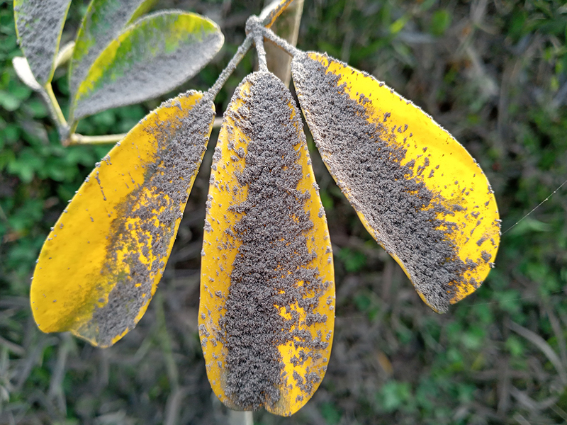 |
Figure 160. Photo of ashfall on leaf in Panimaché I taken in early March 2022. Courtesy of Amilcar Calderas, INSIVUMEH. |
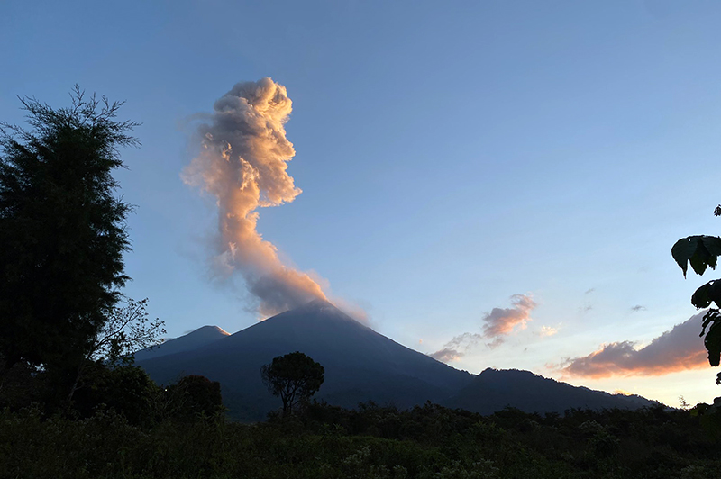 |
Figure 161. Photo of an ash plume rising from Fuego on 14 March 2022. Courtesy of Beth Bartel, Michigan Technological University. |
Geological Summary. Volcán Fuego, one of Central America's most active volcanoes, is also one of three large stratovolcanoes overlooking Guatemala's former capital, Antigua. The scarp of an older edifice, Meseta, lies between Fuego and Acatenango to the north. Construction of Meseta dates back to about 230,000 years and continued until the late Pleistocene or early Holocene. Collapse of Meseta may have produced the massive Escuintla debris-avalanche deposit, which extends about 50 km onto the Pacific coastal plain. Growth of the modern Fuego volcano followed, continuing the southward migration of volcanism that began at the mostly andesitic Acatenango. Eruptions at Fuego have become more mafic with time, and most historical activity has produced basaltic rocks. Frequent vigorous eruptions have been recorded since the onset of the Spanish era in 1524, and have produced major ashfalls, along with occasional pyroclastic flows and lava flows.
Information Contacts: Instituto Nacional de Sismologia, Vulcanologia, Meteorologia e Hydrologia (INSIVUMEH), Unit of Volcanology, Geologic Department of Investigation and Services, 7a Av. 14-57, Zona 13, Guatemala City, Guatemala (URL: http://www.insivumeh.gob.gt/ ); Coordinadora Nacional para la Reducción de Desastres (CONRED), Av. Hincapié 21-72, Zona 13, Guatemala City, Guatemala (URL: http://conred.gob.gt/www/index.php); MIROVA (Middle InfraRed Observation of Volcanic Activity), a collaborative project between the Universities of Turin and Florence (Italy) supported by the Centre for Volcanic Risk of the Italian Civil Protection Department (URL: http://www.mirovaweb.it/); Hawai'i Institute of Geophysics and Planetology (HIGP) - MODVOLC Thermal Alerts System, School of Ocean and Earth Science and Technology (SOEST), Univ. of Hawai'i, 2525 Correa Road, Honolulu, HI 96822, USA (URL: http://modis.higp.hawaii.edu/); Sentinel Hub Playground (URL: https://www.sentinel-hub.com/explore/sentinel-playground); Amilcar Calderas, Instituto Nacional de Sismologia, Vulcanologia, Meteorologia e Hydrologia (INSIVUMEH), Unit of Volcanology, Geologic Department of Investigation and Services, 7a Av. 14-57, Zona 13, Guatemala City, Guatemala (URL: https://www.facebook.com/amilcar.calderas); Beth Bartel, Michigan Technological University, 1400 Townsend Drive, Houghton, Michigan 49931-1295 (URL: https://twitter.com/EatTheCrust).