Report on Gaua (Vanuatu) — June 2022
Bulletin of the Global Volcanism Network, vol. 47, no. 6 (June 2022)
Managing Editor: Edward Venzke.
Edited by Kadie L. Bennis.
Gaua (Vanuatu) Ash plumes visible in November 2021 and April 2022
Please cite this report as:
Global Volcanism Program, 2022. Report on Gaua (Vanuatu) (Bennis, K.L., and Venzke, E., eds.). Bulletin of the Global Volcanism Network, 47:6. Smithsonian Institution. https://doi.org/10.5479/si.GVP.BGVN202206-257020
Gaua
Vanuatu
14.281°S, 167.514°E; summit elev. 729 m
All times are local (unless otherwise noted)
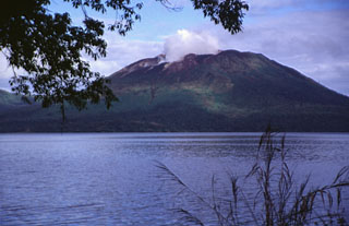
Gaua Island in Vanuatu, also known as Santa María, is roughly 20 km in diameter and consists of a stratovolcano with a 6 x 9 km-wide summit caldera. Mount Garet (also known as Garat) in the SW part of the caldera is the active cone, with three pit craters across the summit area, and is the dominant site of eruptions recorded since July 1962. The crescent-shaped Lake Letas is east of Mount Garet. The most recent eruption period occurred during 17 September-10 October 2011. This report updates information since July 2013 through May 2022 and uses information primarily from monthly bulletins of the Vanuatu Meteorology and Geo-Hazards Department (VMGD) and various satellite data.
Occasional gas-and-steam emissions originating from Mt. Garet have been reported by VMGD and were visible in satellite imagery and by local observers. In addition, local residents and visitors occasionally reported the smell of sulfur near the cone. A white gas-and-steam emission was visible in Planet Labs satellite imagery on 28 September 2016 (figure 25). Similar gas-and-steam emissions were reported on 31 October 2017, 8 December 2017, 19 March 2018 in monthly VMGD reports. Ongoing gas-and-steam emissions from Mt. Garet persisted through May 2022, based on satellite images and reports from local observers (figure 26).
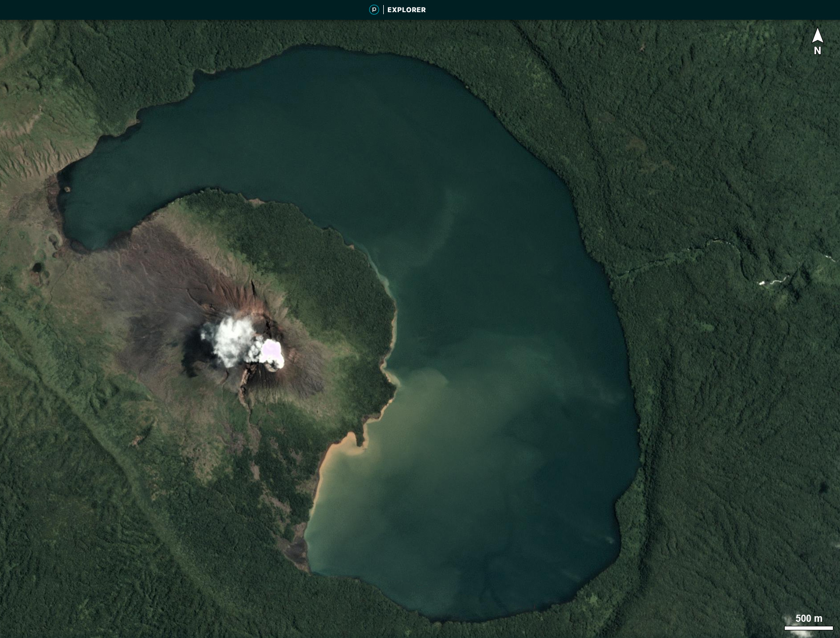 |
Figure 25. Planet Labs satellite image of white gas-and-steam emissions rising above Mt. Garet at Gaua on 28 September 2016. North is to the top of the figure. Courtesy of Planet Labs. |
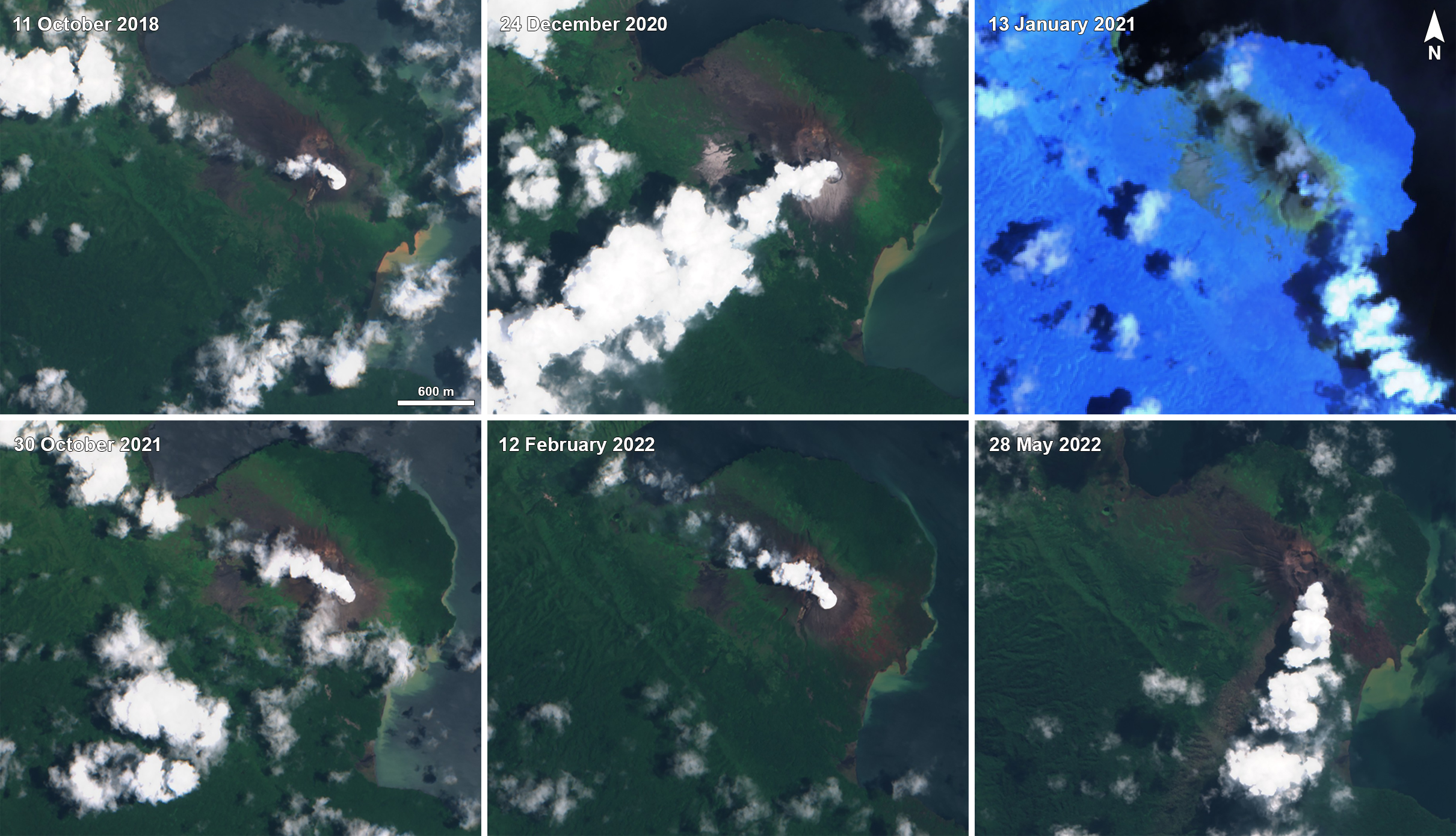 |
Figure 26. Sentinel-2 satellite imagery showed intermittent white gas-and-steam plumes rising above Mt. Garet at Gaua from 11 October 2018 through 28 May 2022 and drifting in different directions. On 13 January 2021 a weak thermal anomaly in the summit crater was detected in an infrared satellite image, accompanied by gas-and-steam emissions. Images show gas-and-steam emissions on 11 October 2018 (top left), 24 December 2020 (top middle), 13 January 2021 (top right), 30 October 2021 (bottom left), 12 February 2022 (bottom middle), and 28 May 2022 (bottom right). The image from 13 January 2021 uses “Atmospheric penetration” rendering (bands 12, 11, 8a) and the rest use “Natural color” (bands 4, 3, 2). Courtesy of Sentinel Hub Playground. |
An ash plume that rose above Mt. Garet on 16 November 2021 was reported by VMGD based on ground observations and satellite data. Ash deposits were also reported in the caldera area and in villages to the west; sulfuric gas odors continued to be noted by visitors. The MIROVA thermal anomaly data showed weak thermal anomalies in late February and mid-April 2022. VMGD warned of a sulfurous odor near the cone on 28 April. On 3 May 2022 local residents, especially in Naveto in the NE part of the island, heard a loud explosion and saw a dense ash plume rising above Mt. Garet during 0900-0930 (figure 27).
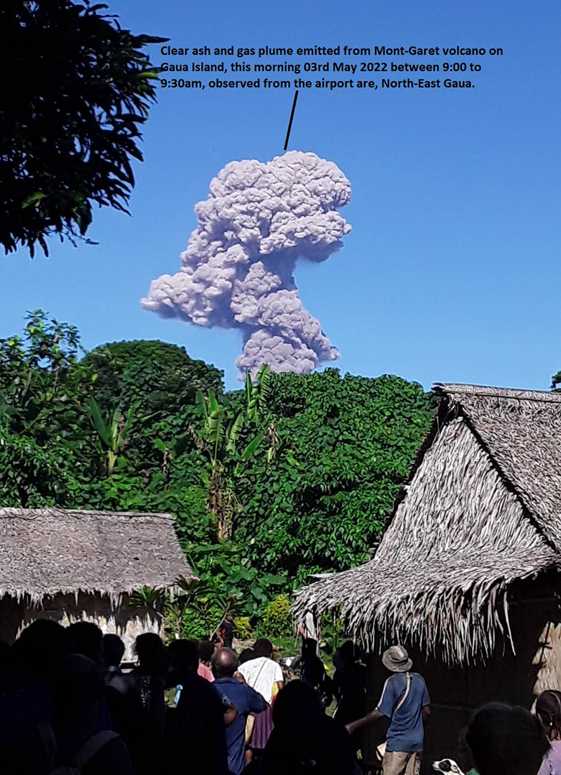 |
Figure 27. Photo of an ash-and-gas plume rising above Mt. Garet at Gaua between 0900-0930 on 3 May 2022. Photo was taken from the NE of the volcano. Courtesy of VMGD. |
Geological Summary. The roughly 20-km-diameter Gaua Island, also known as Santa Maria, consists of a basaltic-to-andesitic stratovolcano with an 6 x 9 km summit caldera. Small vents near the caldera rim fed Pleistocene lava flows that reached the coast on several sides of the island; littoral cones were formed where these lava flows reached the ocean. Quiet collapse that formed the roughly 700-m-deep caldera was followed by extensive ash eruptions. The active Mount Garet (or Garat) cone in the SW part of the caldera has three pit craters across the summit area. Construction of Garet and other small cinder cones has left a crescent-shaped lake. The onset of eruptive activity from a vent high on the SE flank in 1962 ended a long period of dormancy.
Information Contacts: Geo-Hazards Division, Vanuatu Meteorology and Geo-Hazards Department (VMGD), Ministry of Climate Change Adaptation, Meteorology, Geo-Hazards, Energy, Environment and Disaster Management, Private Mail Bag 9054, Lini Highway, Port Vila, Vanuatu (URL: http://www.vmgd.gov.vu/, https://www.facebook.com/VanuatuGeohazardsObservatory/); MIROVA (Middle InfraRed Observation of Volcanic Activity), a collaborative project between the Universities of Turin and Florence (Italy) supported by the Centre for Volcanic Risk of the Italian Civil Protection Department (URL: http://www.mirovaweb.it/); Sentinel Hub Playground (URL: https://www.sentinel-hub.com/explore/sentinel-playground).