Report on Ulawun (Papua New Guinea) — July 2022

Bulletin of the Global Volcanism Network, vol. 47, no. 7 (July 2022)
Managing Editor: Benjamin Andrews.
Edited by Kadie L. Bennis.
Ulawun (Papua New Guinea) New ash eruption and light ashfall on 2 June 2022
Please cite this report as:
Global Volcanism Program, 2022. Report on Ulawun (Papua New Guinea) (Bennis, K.L., and Andrews, B., eds.). Bulletin of the Global Volcanism Network, 47:7. Smithsonian Institution. https://doi.org/10.5479/si.GVP.BGVN202207-252120
Ulawun
Papua New Guinea
5.05°S, 151.33°E; summit elev. 2334 m
All times are local (unless otherwise noted)
Ulawun rises above the N coast of New Britain, Papua New Guinea, and is part of the Bismarck arc. Documented eruptions date back to the 18th century and mildly explosive eruptions occurred during the 20th century through 1967. The most recent eruption began in July 2021 and ended on 29 November 2021, which was primarily characterized by ash eruptions, seismicity, small thermal anomalies, and sulfur dioxide emissions (BGVN 46:12). This report covers a new eruption on 2 June 2022 using information from the Rabaul Volcano Observatory (RVO), the Darwin Volcanic Ash Advisory Centre (VAAC), and satellite data.
Activity during December 2021 and May 2022 was relatively low and consisted mostly of intermittent sulfur dioxide emissions, based on data from the TROPOMI instrument on the Sentinel-5P satellite (figure 30). According to a report from RVO, a short, single day eruption was detected at 0820 on 2 June 2022. Dense ash plumes were visible rising about 3 km above the summit and drifting NW for 10-15 minutes, causing light ashfall in downwind areas to the SE, including Ulamona Mission and on Lolobau Island. A sulfur dioxide plume drifting to the NW was detected by the TROPOMI instrument aboard the Sentinel-5P satellite; maximum column abundance more than 2 Dobson Units (DU) was detected in the plume. On 3 June diffuse white gas-and-steam plumes were visible rising above the summit. Seismicity increased during this event, dominated by continuous volcanic tremors, and consisted of RSAM units between 400 and 500. After the eruption, the units dropped back to lower levels of less than 100 and by the end of June, they had risen to 200.
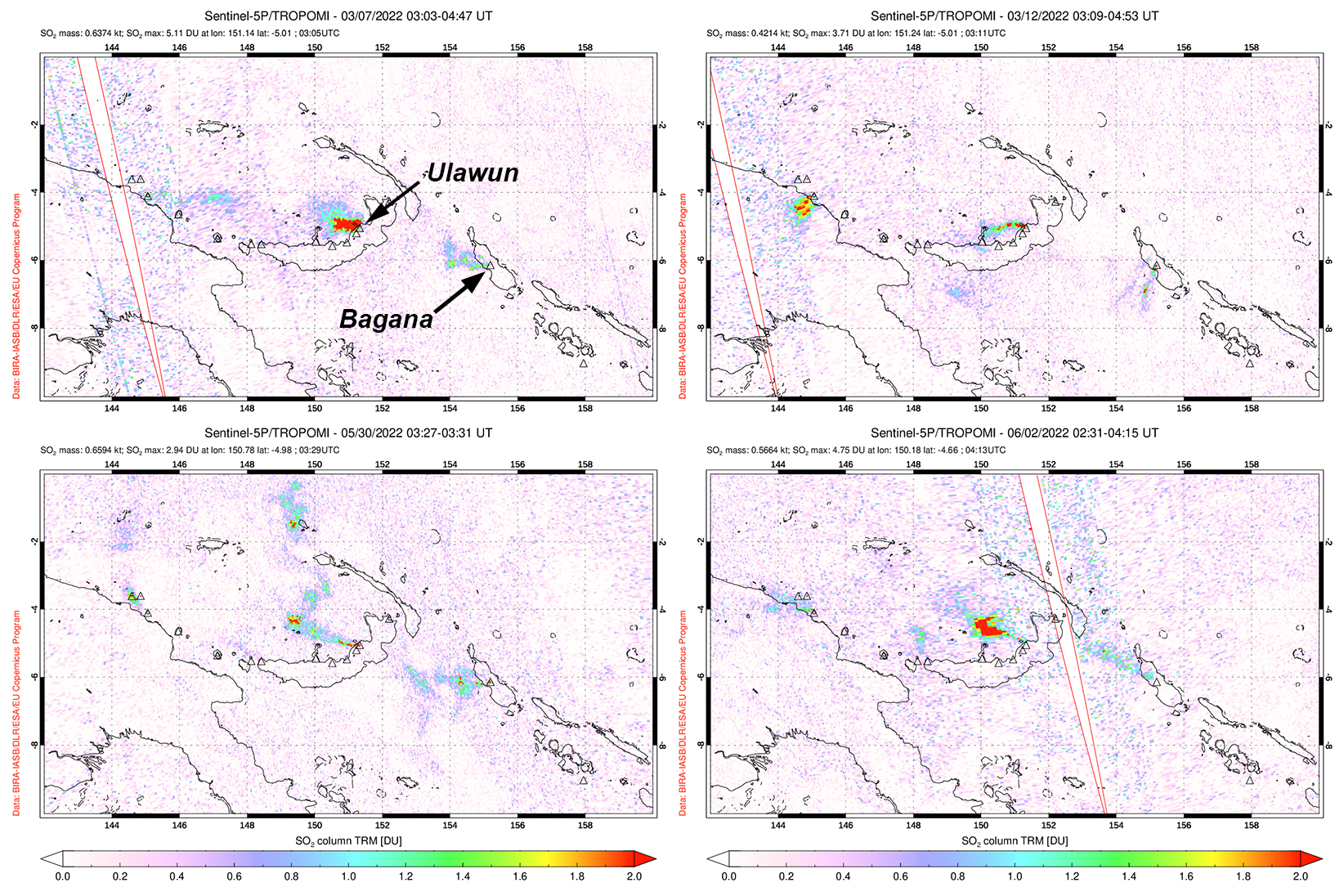 |
Figure 30. Sentinel-5P/TROPOMI data showing intermittent sulfur dioxide plumes above originating from Ulawun on 7 March 2022 (top left), 12 March 2022 (top right), 30 May 2022 (bottom left), and 2 June 2022 (bottom right) that generally drifted W and NW. Each of these plumes exceeded 2 Dobson Units (DU). Courtesy of NASA Global Sulfur Dioxide Monitoring Page. |
Geological Summary. The symmetrical basaltic-to-andesitic Ulawun stratovolcano is the highest volcano of the Bismarck arc, and one of Papua New Guinea's most frequently active. The volcano, also known as the Father, rises above the N coast of the island of New Britain across a low saddle NE of Bamus volcano, the South Son. The upper 1,000 m is unvegetated. A prominent E-W escarpment on the south may be the result of large-scale slumping. Satellitic cones occupy the NW and E flanks. A steep-walled valley cuts the NW side, and a flank lava-flow complex lies to the south of this valley. Historical eruptions date back to the beginning of the 18th century. Twentieth-century eruptions were mildly explosive until 1967, but after 1970 several larger eruptions produced lava flows and basaltic pyroclastic flows, greatly modifying the summit crater.
Information Contacts: Rabaul Volcano Observatory (RVO), Geohazards Management Division, Department of Mineral Policy and Geohazards Management (DMPGM), PO Box 3386, Kokopo, East New Britain Province, Papua New Guinea; Darwin Volcanic Ash Advisory Centre (VAAC), Bureau of Meteorology, Northern Territory Regional Office, PO Box 40050, Casuarina, NT 0811, Australia (URL: http://www.bom.gov.au/info/vaac/); NASA Global Sulfur Dioxide Monitoring Page, Atmospheric Chemistry and Dynamics Laboratory, NASA Goddard Space Flight Center (NASA/GSFC), 8800 Greenbelt Road, Goddard, Maryland, USA (URL: https://so2.gsfc.nasa.gov/).