Report on Manam (Papua New Guinea) — August 2022

Bulletin of the Global Volcanism Network, vol. 47, no. 8 (August 2022)
Managing Editor: Edward Venzke.
Edited by Kadie L. Bennis.
Manam (Papua New Guinea) Strong Strombolian explosions and ash plumes during March-April 2022
Please cite this report as:
Global Volcanism Program, 2022. Report on Manam (Papua New Guinea) (Bennis, K.L., and Venzke, E., eds.). Bulletin of the Global Volcanism Network, 47:8. Smithsonian Institution.
Manam
Papua New Guinea
4.08°S, 145.037°E; summit elev. 1807 m
All times are local (unless otherwise noted)
Manam is located 13 km off the N coast of mainland Papua New Guinea and has had eruptions recorded since 1616. It consists of two active summit craters, Main and South, which occasionally produce Strombolian activity, lava flows, pyroclastic flows, and ash plumes. The current eruption period has been ongoing since 2014. More recent activity included a strong explosion in October 2021, intermittent ash plumes, sulfur dioxide plumes, and thermal anomalies (BGVN 46:11). This report updates activity characterized by Strombolian explosions, strong ash plumes, and thermal activity during November 2021 through July 2022 using information primarily from the Rabaul Volcano Observatory (RVO), the Darwin Volcanic Ash Advisory Center (VAAC), and various satellite data.
Activity was relatively low during November through mid-December 2021 and consisted of intermittent ash plumes and sulfur dioxide plumes (figure 87). Intermittent sulfur dioxide plumes were detected using the TROPOMI instrument on the Sentinel-5P satellite, some of which exceeded at least two Dobson Units (DU) and drifted in different directions. Ash plumes on 3 and 8 November rose to 1.8 km altitude and drifted NW and W, according to HIMAWARI-8 satellite data and weather models from the Darwin VAAC. Ash plumes rose to 6 km altitude and drifted SW on 15 and 16 December, but had dissipated by mid-morning on the 16th. A thermal anomaly was also visible during 14-16 December. Minor ash emissions continued during 16 December, rising to 2.4 km altitude and drifting S, according to an RVO ground report. During 17-18 December ground observers saw a continuous ash plume rise to 3.4 km altitude and drift SE; a hotspot remained visible in satellite imagery. A discrete ash emission rose to 1.5 km altitude and drifted NE at 1600 on 21 December; later that day, discrete ash emissions rose to 3.4 km altitude and drifted SE, and the hotspot remained. Ash plumes may have risen to 10.7 km altitude and drifted S and SW during 0137-0300 on 22 December, though weather clouds and heavy rain obscured satellite views and the plumes were unconfirmed by ground observers. At 1200 later that day, an ash plume rose to 4.9 km altitude and drifted E.
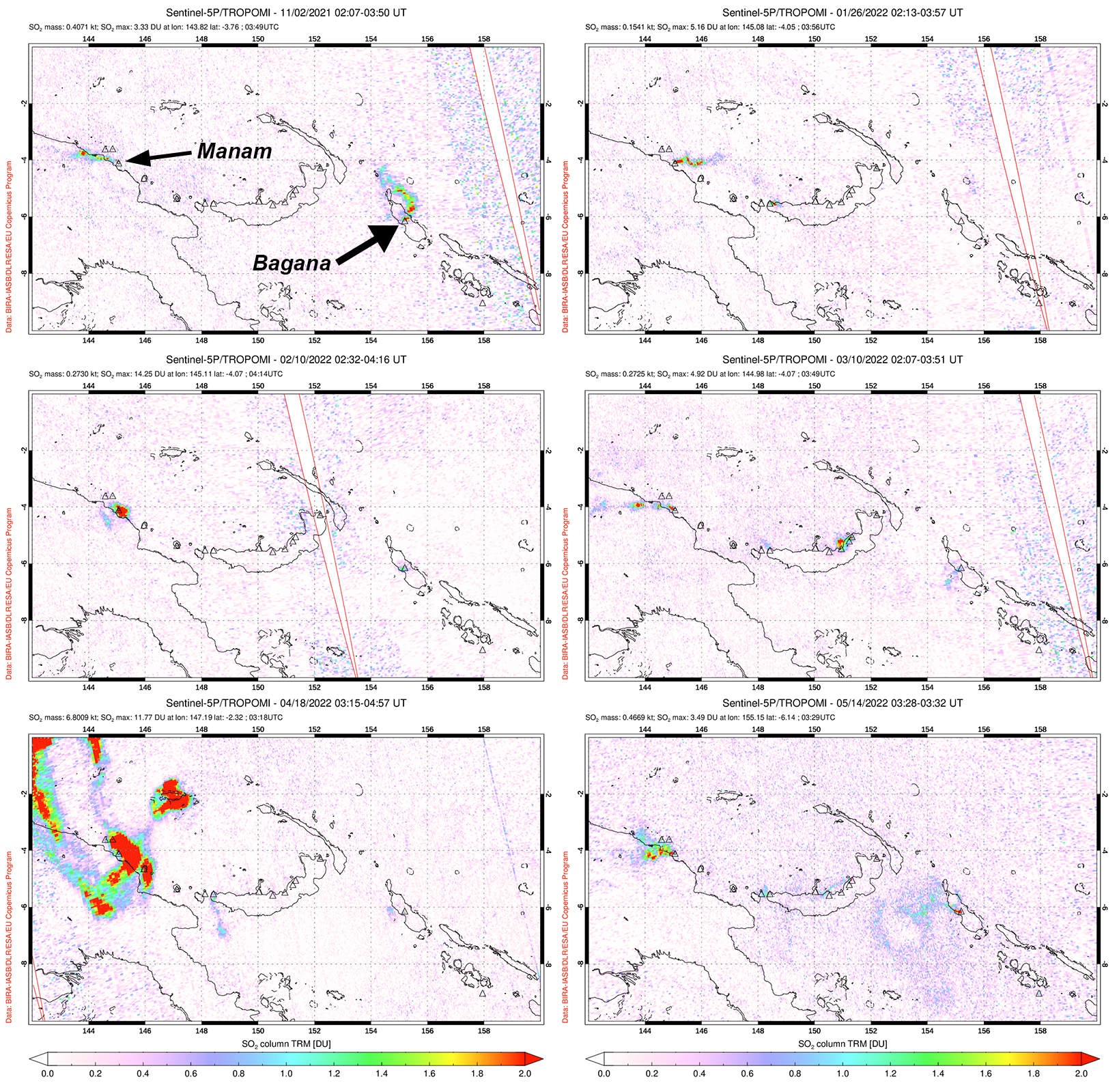 |
Figure 87. Small but distinct sulfur dioxide plumes rising from Manam were detected using data from the TROPOMI instrument on the Sentinel-5P satellite on 2 November 2021 (top left), 26 January 2022 (top right), 10 February 2022 (middle left), 10 March 2022 (middle right), 18 April 2022 (bottom left), and 14 May 2022 (bottom right). Plumes generally drifted in different directions, and the ones shown here exceeded 2 Dobson Units (DU). On 18 April 2022 a strong sulfur dioxide plume was captured above Manam and had a mass of about 6.8 kilotons. Courtesy of the NASA Global Sulfur Dioxide Monitoring Page. |
Stronger activity resumed in March 2022. RVO reported that a small pyroclastic flow was visually observed and recorded in webcam images at 0911 on 8 March. RSAM values increased markedly at 1900, which was reflected in the heightened activity. Minor ash emissions were also observed throughout the day and drifted NW. Intense Strombolian explosions in the South crater observed during 1910-2030 produced loud roaring and rumbling sounds heard on the mainland (22 km SW). Bright summit incandescence and ash emissions were also reported. The Darwin VAAC estimated that on 8 March a high ash plume rose to 15.2 km altitude and drifted W based on RGB satellite imagery. The plume detached from the summit around 2050; lower ash emissions rose to 3 km altitude and continued to extend to the W, though it had dissipated by 0050 on 9 March. The Volcano Alert Level (VAL) was raised to a 3. The next day, staff conducted a field visit and reported no roof collapses or casualties in areas to the NW; vegetation including food crops were covered with ash. After the intense eruption phase at the South crater, white gas-and-steam emissions were visible drifting W. Ash plumes rose to 2.4-3 km altitude and drifted W, SW, and NW during 14-17 March, according to the Darwin VAAC. A thermal anomaly was also detected in RGB satellite imagery on 16 March.
A strong ash plume was also detected in April. On 18 April a high-level ash plume rose to 13.7 km altitude and drifted E and N, according to RVO, RGB and satellite imagery, and weather models. Another ash plume was detected at 2000 that same day and rose to 4.9 km altitude and drifted NE; ash dissipated by 0830 on 19 April. On 30 April a continuous ash emission rose to 2.4 km altitude and drifted E. During May, intermittent ash plumes persisted. RVO reported ash emissions rose to 1.8-2.7 km altitude and drifted SE, ESE, NW, and WNW during 1-7 May, based on satellite imagery and ground reporters. Continuous ash plumes during 13-19 May rose to 2.4-3.7 km altitude and extended SW, W, NE, and NW. Similar ash plumes persisted during 25-29 May and rose to 2.1-2.4 km altitude and drifted in different directions; on 28 May a hotspot was also visible in RGB satellite imagery. An eruptive event at 0657 on 27 May was observed by RVO and webcam images, which produced an ash plume that rose to 2.4 km altitude.
Intermittent ash plumes continued during early June and mid-July. During 1-3 and 5 June ash plumes rose to 2.4-3 km altitude and drifted SW, W, and NW based on ground observations, satellite imagery, and reports from RVO. On 14 July ash plumes rose to 2.1 km altitude and drifted NW, according to satellite and RVO webcam images.
Multiple distinct thermal pulses were recorded during October 2021 through July 2022, as recorded by the MIROVA (Middle InfraRed Observation of Volcanic Activity) system (figure 88). Pulses occurred during October, early December, early January, March, mid-April through May, and July. The pulses in January and March were slightly stronger than the others. A total of 56 thermal anomalies were detected by the MODVOLC thermal alerts system, which occurred near the summit craters on 28 and 30 November 2021, 3, 5, and 21 December 2021, 3, 10, 12, 15, and 16 January 2022, 18 February 2022, 8, 18, and 20 March 2022, 23, 25, and 28 May 2022, and 1, 13, 19, and 23 July 2022. Much of this thermal activity was also captured in Sentinel-2 infrared satellite images on clear weather days, dominantly in the South summit crater, but also occasionally in both the Main and South craters (figure 89). Two thermal anomalies were visible on each of these days: 10 November 2021, 23 February 2022, and 14 April 2022.
 |
Figure 88. Distinct pulses of thermal activity at Manam were recorded during October 2021 through July 2022, as shown in this MIROVA graph (Log Radiative Power). Courtesy of MIROVA. |
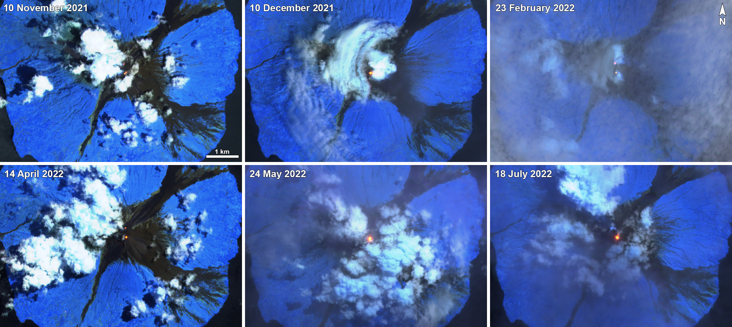 |
Figure 89. Sentinel-2 infrared satellite images show a persistent thermal anomaly (bright yellow-orange) dominantly at the South summit crater on 10 November 2021 (top left), 10 December 2021 (top middle), 23 February 2022 (top right), 14 April 2022 (bottom left), 24 May 2022 (bottom middle), and 18 July 2022 (bottom right). The Main summit crater also showed a thermal hotspot on 10 November 2021, 23 February 2022, and 14 April 2022. Sentinel-2 satellite images with “Atmospheric penetration” (bands 12, 11, 8A) rendering. Courtesy of Sentinel Hub Playground. |
Geological Summary. The 10-km-wide island of Manam, lying 13 km off the northern coast of mainland Papua New Guinea, is one of the country's most active volcanoes. Four large radial valleys extend from the unvegetated summit of the conical basaltic-andesitic stratovolcano to its lower flanks. These valleys channel lava flows and pyroclastic avalanches that have sometimes reached the coast. Five small satellitic centers are located near the island's shoreline on the northern, southern, and western sides. Two summit craters are present; both are active, although most observed eruptions have originated from the southern crater, concentrating eruptive products during much of the past century into the SE valley. Frequent eruptions, typically of mild-to-moderate scale, have been recorded since 1616. Occasional larger eruptions have produced pyroclastic flows and lava flows that reached flat-lying coastal areas and entered the sea, sometimes impacting populated areas.
Information Contacts: Rabaul Volcano Observatory (RVO), Geohazards Management Division, Department of Mineral Policy and Geohazards Management (DMPGM), PO Box 3386, Kokopo, East New Britain Province, Papua New Guinea; Darwin Volcanic Ash Advisory Centre (VAAC), Bureau of Meteorology, Northern Territory Regional Office, PO Box 40050, Casuarina, NT 0811, Australia (URL: http://www.bom.gov.au/info/vaac/); MIROVA (Middle InfraRed Observation of Volcanic Activity), a collaborative project between the Universities of Turin and Florence (Italy) supported by the Centre for Volcanic Risk of the Italian Civil Protection Department (URL: http://www.mirovaweb.it/); Hawai'i Institute of Geophysics and Planetology (HIGP) - MODVOLC Thermal Alerts System, School of Ocean and Earth Science and Technology (SOEST), Univ. of Hawai'i, 2525 Correa Road, Honolulu, HI 96822, USA (URL: http://modis.higp.hawaii.edu/); NASA Global Sulfur Dioxide Monitoring Page, Atmospheric Chemistry and Dynamics Laboratory, NASA Goddard Space Flight Center (NASA/GSFC), 8800 Greenbelt Road, Goddard, Maryland, USA (URL: https://so2.gsfc.nasa.gov/); Sentinel Hub Playground (URL: https://www.sentinel-hub.com/explore/sentinel-playground).