Report on Fuego (Guatemala) — August 2022

Bulletin of the Global Volcanism Network, vol. 47, no. 8 (August 2022)
Managing Editor: Edward Venzke.
Edited by Kadie L. Bennis.
Fuego (Guatemala) Daily explosions, ash plumes, incandescent block avalanches, and ashfall during April-July 2022
Please cite this report as:
Global Volcanism Program, 2022. Report on Fuego (Guatemala) (Bennis, K.L., and Venzke, E., eds.). Bulletin of the Global Volcanism Network, 47:8. Smithsonian Institution.
Fuego
Guatemala
14.4748°N, 90.8806°W; summit elev. 3799 m
All times are local (unless otherwise noted)
Fuego has been vigorously erupting since January 2002, but has recorded eruptions dating back to 1531 CE. It is one of three large stratovolcanoes overlooking the city of Antigua, Guatemala. Eruption activity has included major ashfalls, pyroclastic flows, lava flows, and lahars. Frequent explosions with ash emissions, block avalanches, and lava flows have persisted since 2018. More recently, activity remained relatively consistent with frequent explosions, ash plumes, incandescent block avalanches, and ashfall (BGVN 47:05). This report covers similar activity during April through July 2022 based on information from the Instituto Nacional de Sismologia, Vulcanología, Meteorología e Hidrologia (INSIVUMEH) daily reports, Coordinadora Nacional para la Reducción de Desastres (CONRED) newsletters, and various satellite data.
The frequent explosions that occurred during April through July 2022 generated shock waves and vibrations that rattled roofs and windows in communities near the volcano. Ash plumes rose to 4.3-5 km altitude each day and drifted in different directions, though dominantly W and SW. The explosions also produced incandescent block avalanches that descended several flank drainages (barrancas), with some of the blocks reaching vegetation near the bottom. Block avalanches were produced due to explosions throughout the reporting period, affecting several drainages including Las Lajas, Ceniza, Santa Teresa, and Trinidad. Incandescent ejecta was reported as high as 400 m. Ashfall was also frequently reported in nearby communities (table 26). The MIROVA graph showed that frequent and moderate thermal activity persisted throughout the reporting period, with short gaps of fewer hotspots during early April and June (figure 162). A total of 28 MODVOLC thermal alerts were issued: eight during April, two during May, six during June, and 12 during July. Sentinel-2 infrared satellite data showed thermal anomalies inside the summit crater, as well as a few incandescent block avalanches (figure 163).
Table 26. Activity at Fuego during April-July 2022 included multiple explosions every hour that produced ash emissions that rose as high as 5 km altitude and drifted generally W and SW as far as 30 km from the volcano. Ashfall was reported in many communities around the volcano. Data from daily INSIVUMEH reports and CONRED newsletters.
| Month | Explosions per hour | Ash plume altitude (km) | Ash plume distance (km) and direction | Communities reporting ashfall |
| Apr 2022 | 1-10 | 4.3-5 | 10-30 km W, S, SW, NW, E | Panimaché I and II, Morelia, Santa Sofía, El Porvenir, Sangre de Cristo, Yepocapa, Finca Palo Verde, Yucales, Finca La Asunción, La Rochela, Celián, El Zapote, San Andrés Osuna, El Rodeo |
| May 2022 | 2-9 | 4.3-5 | 10-30 km N, NE, E, SW, S, E, SE, W | Panimaché I and II, Morelia, Santa Sofía, Yucales, La Soledad, Finca Palo Verde, Yepocapa, Finca la Asunción, La Rochela, Celián, Osuna, El Porvenir, Alotenago, San Miguel Dueñas, San Sebastián, El Zapote, La Soledad, Acatenago, Parramos |
| Jun 2022 | 1-10 | 4.3-5 | 10-30 km E, NE, SE, W, SW, NW | Alotenango, San Miguel Dueñas, Ciudad Vieja, Antigua Guatemala, El Zapote, El Rodeo, San Lucas Sacatpéquez, Yepocapa, Quisaché, Santa Isabel, Sangre de Cristo, Ojo de Agua, Montellano, Buena Vista, San Miguel Pochuta, Panimaché I, Morelia, Santa Sofía, Finca Palo Verde, Yucales, El Porvenir |
| Jul 2022 | 2-10 | 4.3-5 | 10-30 km W, SW, NW | Panimaché I and II, Morelia, Santa Sofía, Finca Palo Verde, Sangre de Cristo, Yepocapa, Yucales, Ojo de Agua, El Porvenir |
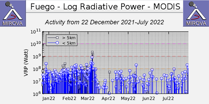 |
Figure 162. Thermal activity at Fuego shown in the MIROVA graph (Log Radiative Power) was at moderate levels during January through July 2022. The frequency of the hotspots decreased after mid-March 2022, with short gaps in activity evident during early April and June. Courtesy of MIROVA. |
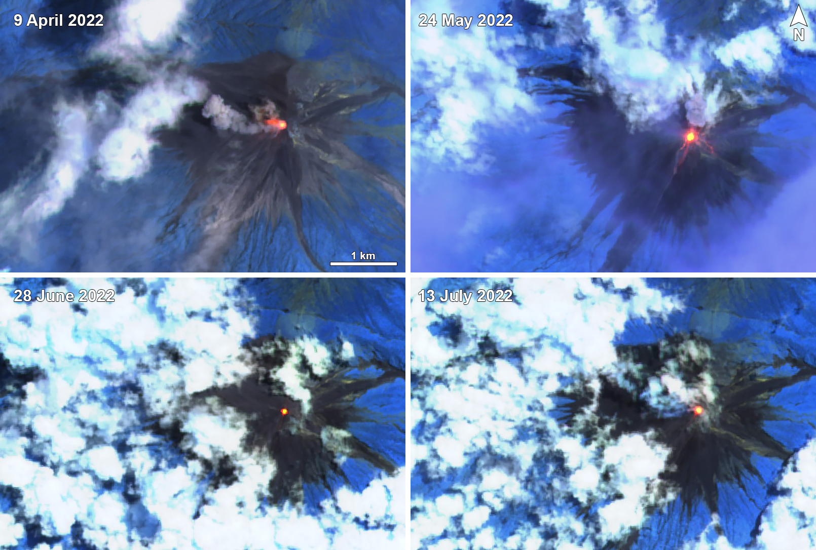 |
Figure 163. Frequent incandescent block avalanches descended multiple drainages at Fuego during April through July 2022, as shown in these Sentinel-2 infrared satellite images on 9 April (top left), 24 May (top right), 28 June (bottom left), and 13 July (bottom right). Ash emissions also occurred daily and are seen on 9 April that drifted NW. Avalanches affected the W flank on 9 April and the S and SW flanks on 24 May. Images use Atmospheric penetration rendering (bands 12, 11, 8a). Courtesy of Sentinel Hub Playground. |
Weak to moderate daily explosions ranged between 1-10 per hour during April 2022, which produced ash plumes that rose as high as 5 km altitude and drifted 10-25 km in multiple directions. Explosions generated block avalanches of various intensities down several nearby drainages, including Las Lajas, Seca, Ceniza, Santa Teresa, Trinidad, Taniluyá, and Honda. On 14 and 20 April the avalanches also descended the Guacalate and Achíguate rivers. Weak to moderate rumbling sounds and shock waves vibrated the roofs and windows of nearby houses. Nighttime incandescence was visible as high as 300 m above the crater; on 23 April pulses of incandescence were seen at 350 m height. Ashfall was reported in Panimaché I and II, Morelia, Santa Sofía, El Porvenir, Sangre de Cristo, Yepocapa, Finca Palo Verde, Yucales, Finca La Asunción, La Rochela, Ceilán, El Zapote, San Andrés Osuna, and El Rodeo.
There were 2-9 daily explosions per hour during May, which generated ash plumes that rose to 4.3-5 km altitude and drifted 10-30 km in various directions. The explosions generated weak shock waves that vibrated the roofs and windows of the nearby houses. Weak to moderate avalanches descended the Ceniza, Taniluyá, Santa Teresa, Honda, Las Lajas, and Trinidad drainages. At night and early morning incandescence was observed at heights of typically 100-300 m above the crater. During the night and early morning of 10-11 May explosions ejected incandescent material up to 350 m high and during 13-14, 19-20, and 24-26 May the pulses rose 300-400 m high. The resulting ashfall was detected in Panimaché I and II, Morelia, Santa Sofía, Yucales, La Soledad, Finca Palo Verde, Yepocapa, Finca La Asunción, La Rochela, Ceilán, and Osuna. Other communities that were less frequently affected by ashfall included El Porvenir, Alotenago, San Miguel Dueñas, San Sebastián, El Zapote, La Soledad, Acatenago, Parramos, Quisaché, and Santa Isabel. On 24 and 27 May rainfall generated lahars in the Las Lajas, El Jute, and Ceniza drainages.
Explosions persisted during June with 1-10 daily explosions per hour. The resulting ash plumes rose to 4.3-5 km altitude and drifted in various directions as far as 10-30 km. Shock waves continued to rattle the nearby roofs and windows of houses. Incandescent pulses rose 100-350 m above the crater. Weak and moderate avalanches continued to occur on the upper part of all the drainages, including Santa Teresa, Taniluyá, Ceniza, Las Lajas, Trinidad, and Honda. Ashfall was reported in some nearby communities, including Panimaché I and II, Morelia, Santa Sofía, Finca Palo Verde, Alotenango, San Miguel Dueñas, Ciudad Vieja, Antigua Guatemala, El Zapote, El Rodeo, San Lucas Sacatpéquez, Yepocapa, Quisaché, Santa Isabel, Sangre de Cristo, Ojo de Agua, Montellano, Buena Vista, San Miguel Pochuta, Yucales, and El Porvenir.
Similar activity was reported each day during July, with 2-10 weak to moderate explosions per hour. Ash plumes rose to 4.3-5 km altitude and drifted as far as 10-30 km mainly W and SW. Ashfall was observed in Panimaché I and II, Morelia, Santa Sofía, Finca Palo Verde, Sangre de Cristo, Yepocapa, Yucales, Ojo de Agua, and El Porvenir. Constant block avalanches were observed descending the Santa Teresa, Ceniza, Trinidad, Taniluyá, Las Lajas, and Honda drainages. Incandescent pulses were visible 100-350 m above the crater. During 4-6 July a lava flow was reported descending 100-200 m down the Ceniza drainage; INSIVUMEH reported that the flow had stopped by 7 July. Another lava flow was observed descending 100 m down the Ceniza drainage on 28 July; by 31 July the flow length was 1,300 m and generated strong block avalanches that produced ash plumes 4.8 km altitude.
Geological Summary. Volcán Fuego, one of Central America's most active volcanoes, is also one of three large stratovolcanoes overlooking Guatemala's former capital, Antigua. The scarp of an older edifice, Meseta, lies between Fuego and Acatenango to the north. Construction of Meseta dates back to about 230,000 years and continued until the late Pleistocene or early Holocene. Collapse of Meseta may have produced the massive Escuintla debris-avalanche deposit, which extends about 50 km onto the Pacific coastal plain. Growth of the modern Fuego volcano followed, continuing the southward migration of volcanism that began at the mostly andesitic Acatenango. Eruptions at Fuego have become more mafic with time, and most historical activity has produced basaltic rocks. Frequent vigorous eruptions have been recorded since the onset of the Spanish era in 1524, and have produced major ashfalls, along with occasional pyroclastic flows and lava flows.
Information Contacts: Instituto Nacional de Sismologia, Vulcanologia, Meteorologia e Hydrologia (INSIVUMEH), Unit of Volcanology, Geologic Department of Investigation and Services, 7a Av. 14-57, Zona 13, Guatemala City, Guatemala (URL: http://www.insivumeh.gob.gt/ ); Coordinadora Nacional para la Reducción de Desastres (CONRED), Av. Hincapié 21-72, Zona 13, Guatemala City, Guatemala (URL: http://conred.gob.gt/www/index.php); MIROVA (Middle InfraRed Observation of Volcanic Activity), a collaborative project between the Universities of Turin and Florence (Italy) supported by the Centre for Volcanic Risk of the Italian Civil Protection Department (URL: http://www.mirovaweb.it/); Hawai'i Institute of Geophysics and Planetology (HIGP) - MODVOLC Thermal Alerts System, School of Ocean and Earth Science and Technology (SOEST), Univ. of Hawai'i, 2525 Correa Road, Honolulu, HI 96822, USA (URL: http://modis.higp.hawaii.edu/); Sentinel Hub Playground (URL: https://www.sentinel-hub.com/explore/sentinel-playground).