Report on Tinakula (Solomon Islands) — October 2022
Bulletin of the Global Volcanism Network, vol. 47, no. 10 (October 2022)
Managing Editor: Edward Venzke.
Research and preparation by Paul Berger.
Tinakula (Solomon Islands) Ongoing thermal anomalies and gas-and-steam plumes during January-September 2022
Please cite this report as:
Global Volcanism Program, 2022. Report on Tinakula (Solomon Islands) (Venzke, E., ed.). Bulletin of the Global Volcanism Network, 47:10. Smithsonian Institution.
Tinakula
Solomon Islands
10.386°S, 165.804°E; summit elev. 796 m
All times are local (unless otherwise noted)
Tinakula is a remote stratovolcano in the SE part of the Solomon Islands. Recent activity began with an ash explosion in October 2017, followed in December 2018 by dense gas-and-steam plumes and weak thermal anomalies (BGVN 44:07, 47:02), which continued into 2022. The current report summarizes activity during January-September 2022 using satellite data, as ground observations are rarely available.
Infrared MODIS satellite data processed by MIROVA (Middle InfraRed Observation of Volcanic Activity) detected intermittent low-power thermal anomalies each month except for September 2022 when none were detected (figure 50). More frequent anomalies were detected from mid-February through March 2022.
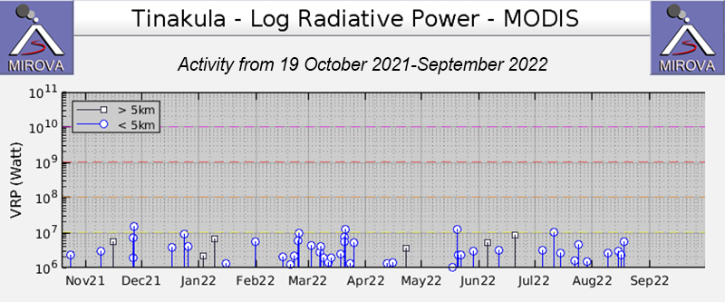 |
Figure 50. Graph of thermal anomalies (Log Radiative Power) at Tinakula from the MIROVA system through September 2022. Courtesy of MIROVA. |
Sentinel-2 satellite imagery showed persistent white gas-and-steam plumes rising from Tinakula during January through September 2022. Almost all observed plumes drifted W or SW and were usually profuse and dense. On the few viewing days when not obscured by the plumes or weather clouds, a thermal anomaly was visible at the summit area (figure 51); three small thermal anomalies were visible on 23 September.
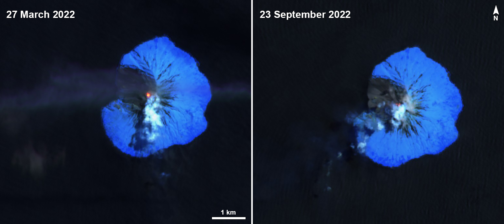 |
Figure 51. Selected Sentinel-2 infrared satellite images of Tinakula showing a thermal anomaly at the summit and associated steam plumes on 27 March (left) and 23 September (right) 2022. Images with Atmospheric penetration (bands 12, 11, 8a) rendering. Courtesy of Sentinel Hub Playground. |
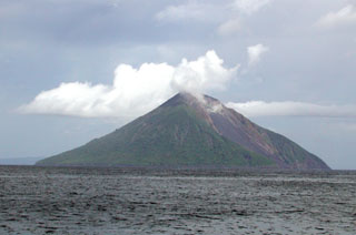
Geological Summary. The small 3.5-km-wide island of Tinakula is the exposed summit of a massive stratovolcano at the NW end of the Santa Cruz islands. It has a breached summit crater that extends from the summit to below sea level. Landslides enlarged this scarp in 1965, creating an embayment on the NW coast. The Mendana cone is located on the SE side. The dominantly andesitic volcano has frequently been observed in eruption since the era of Spanish exploration began in 1595. In about 1840, an explosive eruption apparently produced pyroclastic flows that swept all sides of the island, killing its inhabitants. Recorded eruptions have frequently originated from a cone constructed within the large breached crater. These have left the upper flanks and the steep apron of lava flows and volcaniclastic debris within the breach unvegetated.
Information Contacts: MIROVA (Middle InfraRed Observation of Volcanic Activity), a collaborative project between the Universities of Turin and Florence (Italy) supported by the Centre for Volcanic Risk of the Italian Civil Protection Department (URL: http://www.mirovaweb.it/); Sentinel Hub Playground (URL: https://www.sentinel-hub.com/explore/sentinel-playground).