Report on Lewotolok (Indonesia) — October 2022
Bulletin of the Global Volcanism Network, vol. 47, no. 10 (October 2022)
Managing Editor: Benjamin Andrews.
Edited by Kadie L. Bennis.
Lewotolok (Indonesia) Strombolian explosions, ash plumes, and crater incandescence during February-September 2022
Please cite this report as:
Global Volcanism Program, 2022. Report on Lewotolok (Indonesia) (Bennis, K.L., and Andrews, B., eds.). Bulletin of the Global Volcanism Network, 47:10. Smithsonian Institution.
Lewotolok
Indonesia
8.274°S, 123.508°E; summit elev. 1431 m
All times are local (unless otherwise noted)
Lewotolok (also known as Lewotolo) is located on the island of Lembata (Lomblen) in the Lesser Sunda Islands of Indonesia. Eruptions have been recorded since 1660, consisting primarily of explosive activity from the summit crater. The current eruption period began in late November 2020 and has been recently characterized by Strombolian explosions, intermittent ash plumes, and incandescent ejecta (BGVN 47:03). This report covers similar explosive activity during February through September 2022 using information from Pusat Vulkanologi dan Mitigasi Bencana Geologi (PVMBG, also known as CVGHM, or the Center of Volcanology and Geological Hazard Mitigation), MAGMA Indonesia, and various satellite data.
Strong Strombolian explosions occurred throughout the reporting period and were often visible on clear nights; accompanying incandescent ejecta rose above the summit crater and extended away from the vent. Intermittent ash plumes were reported rising to a maximum of 3.8 km altitude on 14 May. Thermal activity based on MIROVA (Middle InfraRed Observation of Volcanic Activity) data showed a period of infrequent, low-power anomalies during February through mid-May 2022 (figure 36). During February one anomaly was detected, during mid-March three anomalies were detected, and during April seven were detected. By early-to-mid May there was a distinctive increase in both power and frequency of the thermal anomalies, which continued through mid-July. After this heightened activity, there was a brief break during late July to early August, in which only one low-power anomaly was registered. During early August and late August, there was a small cluster of anomalies that were detected, as well as during mid-September. The heightened thermal activity during May through mid-July was also recorded in data from the MODVOLC Thermal Algorithm; a total of 18 hotspots were detected on 15 March, 13, 16, 27, and 30 May, 1, 5, 15, 19, and 28 June, 5 July, and 9 and 27 August. Sentinel-2 infrared satellite imagery provided thermal and visual evidence of thermal activity at the summit crater on clear weather days throughout the reporting period (figure 37).
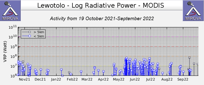 |
Figure 36. A period of low thermal activity was detected at Lewotolok during February through mid-May 2022, as shown by this MIROVA plot of Log Radiative Power. One anomaly was detected during mid-February, three during mid-March, and seven during April. Then, during early-to-mid May activity increased in both frequency and strength and continued at a higher level through mid-July 2022. A few strong anomalies were also recorded during early and late August, and then during mid-September. Courtesy of MIROVA. |
 |
Figure 37. Sentinel-2 infrared satellite images showed a small-to-moderate sized thermal anomaly at the summit crater of Lewotolok during 7 February 2022 (top left), 24 March (top right), 23 April (middle left), 23 May (middle right), 12 June (bottom left), and 2 July (bottom right). Some incandescent material was also visible on the flanks. On 7 February material was distributed to the SE. On 24 March and 23 April material moved to the NW. On 23 May and 12 June incandescent material was on the N and NE flanks. On 2 July material could be seen at the base of the NE flank. Sentinel-2 satellite imagery uses Atmospheric penetration rendering (bands 12, 11, 8a). Courtesy of Sentinel Hub Playground. |
During February Strombolian explosions, incandescent ejecta, and minor crater incandescence at the summit was visible during the night in webcam images (figure 38). White, gray, and black plumes rose 25-1,200 m above the summit and drifted in different directions. On 11 February at 0743 an eruption of ash emissions rose to 2.6 km altitude and drifted E, according to a ground observer. Similar ash emissions were reported in VONA (Volcano Observatory Notice for Aviation) notices on 12 and 14 February, where the ash emissions rose to 2.2 and 2.1 km altitude and drifted E and SW, respectively (figure 39). A webcam image captured at 0210 on 18 February showed Strombolian activity and incandescent material on the flank. A white and-gray plume rose 700 m high above the crater and drifted E on 19 February. During March white-and-gray plumes rose 10-1,000 m above the main summit crater and drifted in different directions. Some webcam images recorded incandescence at the summit. On 10 and 11 March a ground observer reported ash emissions rising to 2 and 2.4 km altitude and drifting W and SW, respectively (figure 39). On 31 March an ash emission rose to 2.2 km altitude and drifted NW.
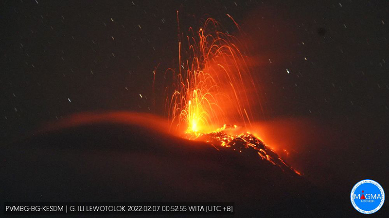 |
Figure 38. Webcam image of a Strombolian explosion at Lewotolok on 7 February 2022 ejecting incandescent material from the crater and accompanied by incandescent material on the nearby flanks. Courtesy of MAGMA Indonesia. |
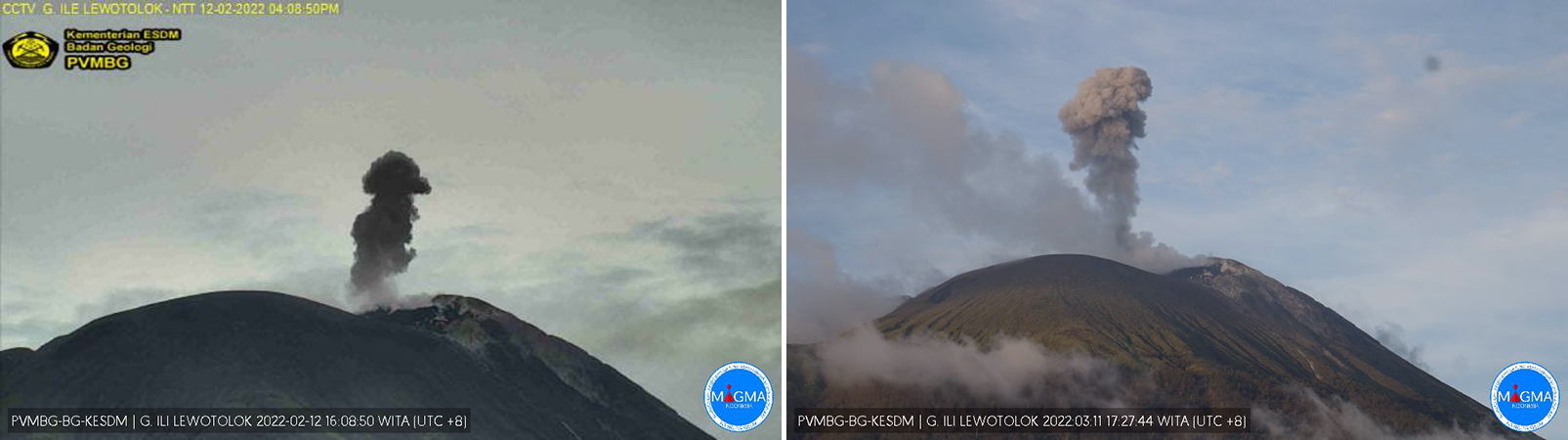 |
Figure 39. Webcam images of ash plumes rising to 2.2 and 2.4 km altitude from Lewotolok at 1608 on 12 February 2022 (left) and at 1727 on 11 March 2022 (right). Courtesy of MAGMA Indonesia. |
Similar activity with intermittent Strombolian explosions, incandescent ejecta, and ash plumes continued during April and May (figure 40). White-and-gray gas-and-steam plumes rose 25-1,200 m above the summit and drifted in different directions. During 29-30 April ash emissions rose to 1.9-2 km altitude and drifted NW and W. Ash emissions during 4-6 May rose to 2 km altitude and drifted W. On 14 May MAGMA Indonesia reported that degassing had increased, and continuing ash emissions were rising to around 3.8 km altitude and drifting N and NE. Similar activity was also reported on 16 May where ash emissions rose to 2.4 km altitude and drifted W.
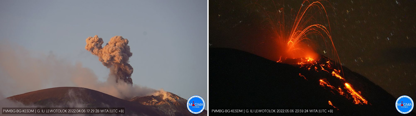 |
Figure 40. Webcam images of an ash plume (left) and Strombolian explosions (right) rising above Lewotolok on 6 April 2022 and 6 May 2022, respectively. Incandescent material was visible on the flanks of the volcano at night. Courtesy of MAGMA Indonesia. |
Strong Strombolian explosions persisted during June and July, with occasional ash plumes rising to 2.7 km altitude and drifting generally W, NW, and SE. Incandescence in the summit crater and incandescent material were often visible in webcam images. White-and-gray gas-and-steam plumes rose 10-1,300 m above the summit and drifted in different directions during June and July. On 8 June an ash emission rose to 2.2 km altitude and drifted NW. Another ash emission on 17 June rose to 2.4 km altitude and drifted W (figure 41). During 1-2 and 7 July ash emissions rose as high as 2.7 km altitude and drifted W, NW, and SE (figure 41).
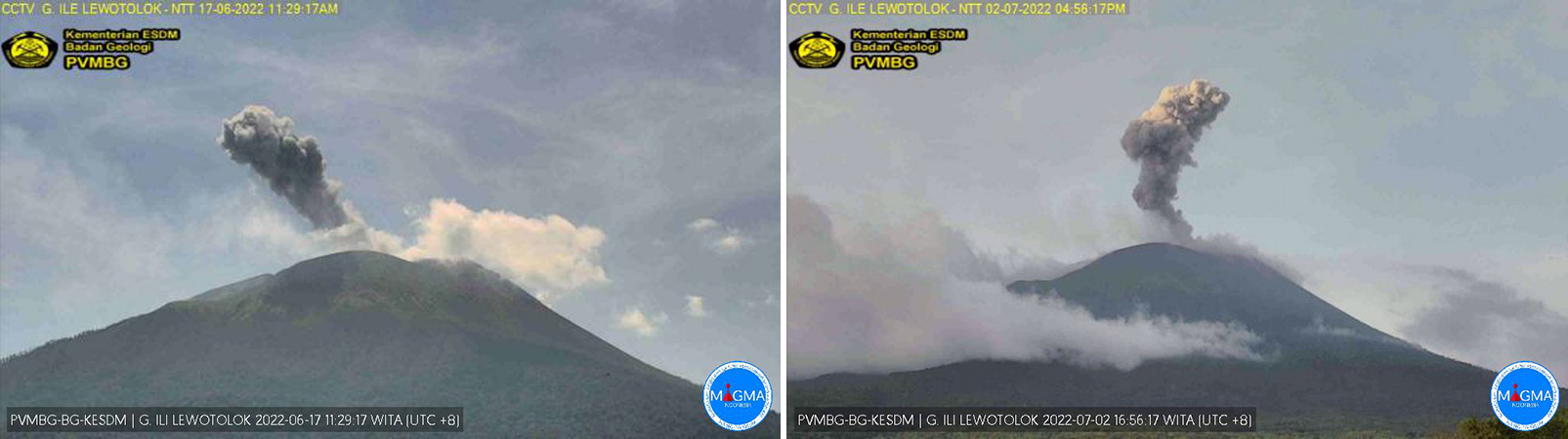 |
Figure 41. Webcam images of ash plumes during 17 June 2022 (left) and 2 July 2022 (right) rising from Lewotolok to 2.4 km altitude and 2.7 km altitude, respectively. Courtesy of MAGMA Indonesia. |
During August through September, white and gray gas-and-steam plumes rose 5-1,000 m above the main summit crater. Photos from MAGMA Indonesia showed occasional incandescent Strombolian explosions at the summit crater during the night, many of which ejected incandescent material above the crater rim. During 1-2 September white, gray, and black gas-and-steam plumes rose as high as 1,500 m above the summit (figure 42). At 0350 on 23 September an eruptive event produced an ash plume that rose 800 m high and drifted W. An image captured at that time showed Strombolian activity ejecting incandescent material above the summit.
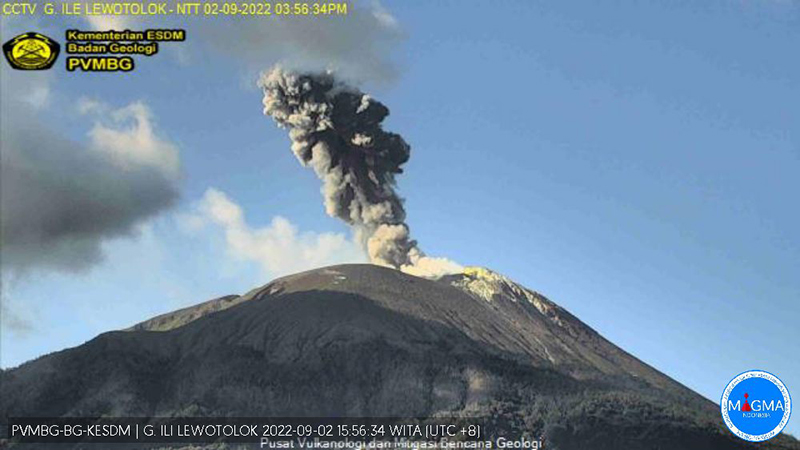 |
Figure 42. Webcam image of an ash plume rising 1.5 km above the summit crater of Lewotolok at 1556 on 2 September 2022. Courtesy of MAGMA Indonesia. |
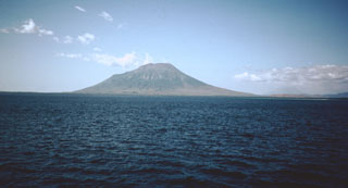
Geological Summary. The Lewotolok (or Lewotolo) stratovolcano occupies the eastern end of an elongated peninsula extending north into the Flores Sea, connected to Lembata (formerly Lomblen) Island by a narrow isthmus. It is symmetrical when viewed from the north and east. A small cone with a 130-m-wide crater constructed at the SE side of a larger crater forms the volcano's high point. Many lava flows have reached the coastline. Eruptions recorded since 1660 have consisted of explosive activity from the summit crater.
Information Contacts: Pusat Vulkanologi dan Mitigasi Bencana Geologi (PVMBG, also known as Indonesian Center for Volcanology and Geological Hazard Mitigation, CVGHM), Jalan Diponegoro 57, Bandung 40122, Indonesia (URL: http://www.vsi.esdm.go.id/); MAGMA Indonesia, Kementerian Energi dan Sumber Daya Mineral (URL: https://magma.esdm.go.id/v1); MIROVA (Middle InfraRed Observation of Volcanic Activity), a collaborative project between the Universities of Turin and Florence (Italy) supported by the Centre for Volcanic Risk of the Italian Civil Protection Department (URL: http://www.mirovaweb.it/); Hawai'i Institute of Geophysics and Planetology (HIGP) - MODVOLC Thermal Alerts System, School of Ocean and Earth Science and Technology (SOEST), Univ. of Hawai'i, 2525 Correa Road, Honolulu, HI 96822, USA (URL: http://modis.higp.hawaii.edu/); Sentinel Hub Playground (URL: https://www.sentinel-hub.com/explore/sentinel-playground).