Report on Semeru (Indonesia) — January 2023

Bulletin of the Global Volcanism Network, vol. 48, no. 1 (January 2023)
Managing Editor: Edward Venzke.
Edited by Kadie L. Bennis.
Semeru (Indonesia) Intermittent gas-and-ash plumes and incandescent avalanches during July-December 2022
Please cite this report as:
Global Volcanism Program, 2023. Report on Semeru (Indonesia) (Bennis, K.L., and Venzke, E., eds.). Bulletin of the Global Volcanism Network, 48:1. Smithsonian Institution.
Semeru
Indonesia
8.108°S, 112.922°E; summit elev. 3657 m
All times are local (unless otherwise noted)
Semeru in East Java, Indonesia contains the active Jonggring-Seloko vent at the Mahameru summit. A line of lake-filled maars was constructed along a N-S trend cutting through the summit, and cinder cones and lava domes occupy the eastern and NE flanks. Frequent 19th and 20th century eruptions were dominated by small-to-moderate explosions from the summit crater, with occasional lava flows and larger explosive eruptions accompanied by pyroclastic flows that have reached the lower flanks of the volcano. The most recent eruption began in June 2017 and more recently has consisted of pyroclastic flows, ash plumes, and an active lava flow (BGVN 47:07). This report covers activity from July through December 2022, dominantly characterized by ash plumes, gas-and-steam plumes, and incandescent avalanches using daily, VONA, and special reports from the Pusat Vulkanologi dan Mitigasi Bencana Geologi (PVMBG, also known as Indonesian Center for Volcanology and Geological Hazard Mitigation, CVGHM), MAGMA Indonesia, and various satellite data.
Activity during July through October mainly consisted of intermittent ash plumes and white gas-and-steam plumes, though weather often obscured clear views of the summit. During July, the ash plumes rose to 3.9-4.6 km altitude and drifted mainly SW; the plume that rose to 4.6 km altitude occurred on 4 and 5 July and drifted N at 0803 and 0534, respectively. In August, the ash plumes rose to 4-4.3 km altitude and drifted SW, W, N, and S. During September, ash plumes rose 300-700 m above the summit and drifted mainly N, SW, and W. Ash plumes during October rose to 3.9-4.1 km altitude and drifted SW, N, W, and S. Intermittent white-to-gray gas-and-steam plumes rose 50-500 m above the summit during October.
During November, white-to-gray gas-and-ash plumes generally rose 50-500 m above the summit. A strong eruptive event at 1550 on 9 November generated a white-to-gray ash plume that rose 1.5 km above the summit and drifted NE. A pyroclastic flow was also reported on 9 November that descended the SE flank as far as 4.5 km at 1550. During 11 and 16 November white gas-and-steam plumes rose 500-1,000 m above the summit and drifted NE, E, and S. A series of eruption events began on 21 November and continued through 28 November. Eruptive activity at 0608 on 21 November produced a white-to-gray ash plume that rose 400 m above the summit and drifted NE (figure 77). At 0503 on 22 November a white-to-gray ash plume rose 600 m above the summit and drifted S (figure 78). Another eruption later that day at 1541 generated a white-and-gray ash plume that rose 800 m above the summit and drifted N and NE. On 23 November at 0002 an eruption generated a gray ash plume that rose 700 m above the summit and drifted SE and S, accompanied by summit crater incandescence (figure 79). White gas-and-steam plumes throughout the 23rd rose 1-1.5 km above the summit and drifted S. On 24 November at 0540 an eruption produced a gray ash plume that rose 500 m above the summit and drifted N. At 0702 on 25 November a gray ash plume rose 500 m above the summit and drifted NE. On 26 November at 0444 a gray ash plume rose 700 m above the summit and drifted S. An eruption event on 28 November at 0556 generated a gray ash plume that rose 600 m above the summit and drifted N.
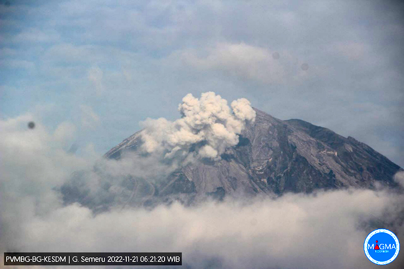 |
Figure 77. Webcam image of a gray ash plume rising 400 m above the summit of Semeru at 0621 on 21 November 2022. Courtesy of MAGMA Indonesia. |
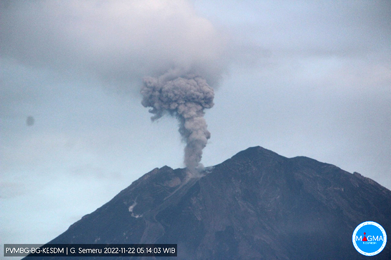 |
Figure 78. Webcam image of a dense, gray ash plume rising 600 m above the summit of Semeru at 0514 on 22 November 2022. Courtesy of MAGMA Indonesia. |
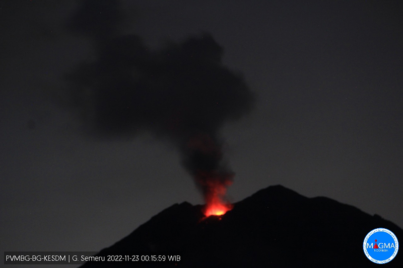 |
Figure 79. Webcam image of summit crater incandescence at Semeru at 0015 on 23 November accompanied by a gray ash plume that rose 700 m above the summit. Courtesy of MAGMA Indonesia. |
Frequent white-to-gray gas-and-ash plumes and occasional avalanches of material occurred during December. The ash plumes generally rose to 3.9-4.6 km altitude and drifted in different directions; avalanches were sometimes captured in webcam images. An eruption at 0550 on 2 December produced a white-to-gray ash plume that rose 500 m above the summit and drifted NE. On 3 December at 0520 a white-to-gray ash plume rose 500 m above the summit and drifted S. On 4 December at 0246 material collapsed on the SE flank, which produced a series of pyroclastic flows that mainly traveled 5-13 km SE and S, and as far as 19 km in those same directions (figure 80). Gray-to-brown ash plumes rose to 5.1 km altitude and drifted SE and S at 0411, and at 0918 similar plumes rose to 8.6 km altitude and drifted SW, W, and NW on 4 December. The ash plumes caused dark conditions and limited visibility, especially in Kajar Kuning (12 km SE) where residents reported dense ashfall and heavy rain. Ejected incandescent material was deposited as far as 8 km from the summit and ashfall was reported in areas 12 km SE. Pyroclastic flows were ongoing at least through 0951, traveling 5-7 km down the flanks. According to BNPB, there were 781 people across 21 evacuation shelters, and heavy ashfall prevented aid from easily reaching Pronojiwo Village.
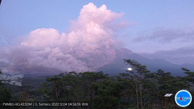 |
Figure 80. Webcam image of a pyroclastic flow descending SE and S Semeru at 0458 on 4 December 2022. Courtesy of MAGMA Indonesia. |
During 4-9 December, four pyroclastic flows moved as far as 6 km down the SE flank, and avalanches of material traveled 300-500 m SE. On 6 December an eruption at 0502 generated a white-to-gray ash plume that rose 400 m above the summit and drifted S and SW. A white-to-gray ash plume on 8 December rose 300 m above the summit and drifted N. On 9 December a dense, gray ash plume rose 500 m above the summit and drifted N at 0521. On 10 December a gray ash plume rose 700 m above the summit and drifted N. An eruption on 16 December at 0455 produced a white and gray-to-brown ash plume that rose 1 km above the summit and drifted N. At 0500 on 18 December a dense gray ash plume rose 300 m above the crater and drifted N and NE and at 0623 and at 0755 white-and-gray ash plumes rose 1 km and 700 m, respectively. On 19 December a gray-to-brown ash plume rose 1.5 km above the summit and drifted N and NE at 1558. On 20 December an ash plume rose 600 m and drifted N.
MIROVA (Middle InfraRed Observation of Volcanic Activity) analysis of MODIS satellite data showed frequent, moderate-strength thermal anomalies during July through December (figure 81). There were two short gaps in thermal activity during November and mid-December. Based on data from the MODVOLC thermal algorithm, 48 thermal hotspots were detected: 14 in July, six in August, 11 in September, eight in October, four in November, and five in December. Thermal anomalies were visible on clear weather days at the summit crater in Sentinel-2 infrared satellite images throughout the reporting period. Occasional incandescent avalanches were captured in infrared satellite images on 9, 14, 19, 24, and 29 July, 3, 8, 13, and 23 August, 17 and 22 September, 1 and 6 November, and 11 and 21 December descending the SE flank (figure 82).
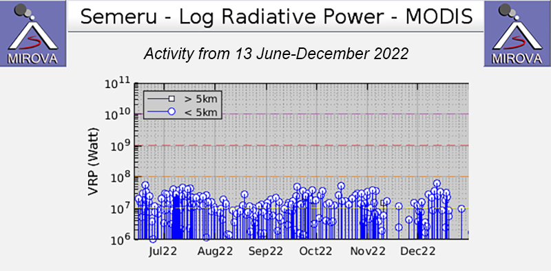 |
Figure 81. Frequent thermal activity was recorded in this MIROVA graph (Log Radiative Power) during July through December 2022. The power of these anomalies fluctuated slightly, but overall were moderately strong. There were two short gaps in thermal activity during November and mid-December. Courtesy of MIROVA. |
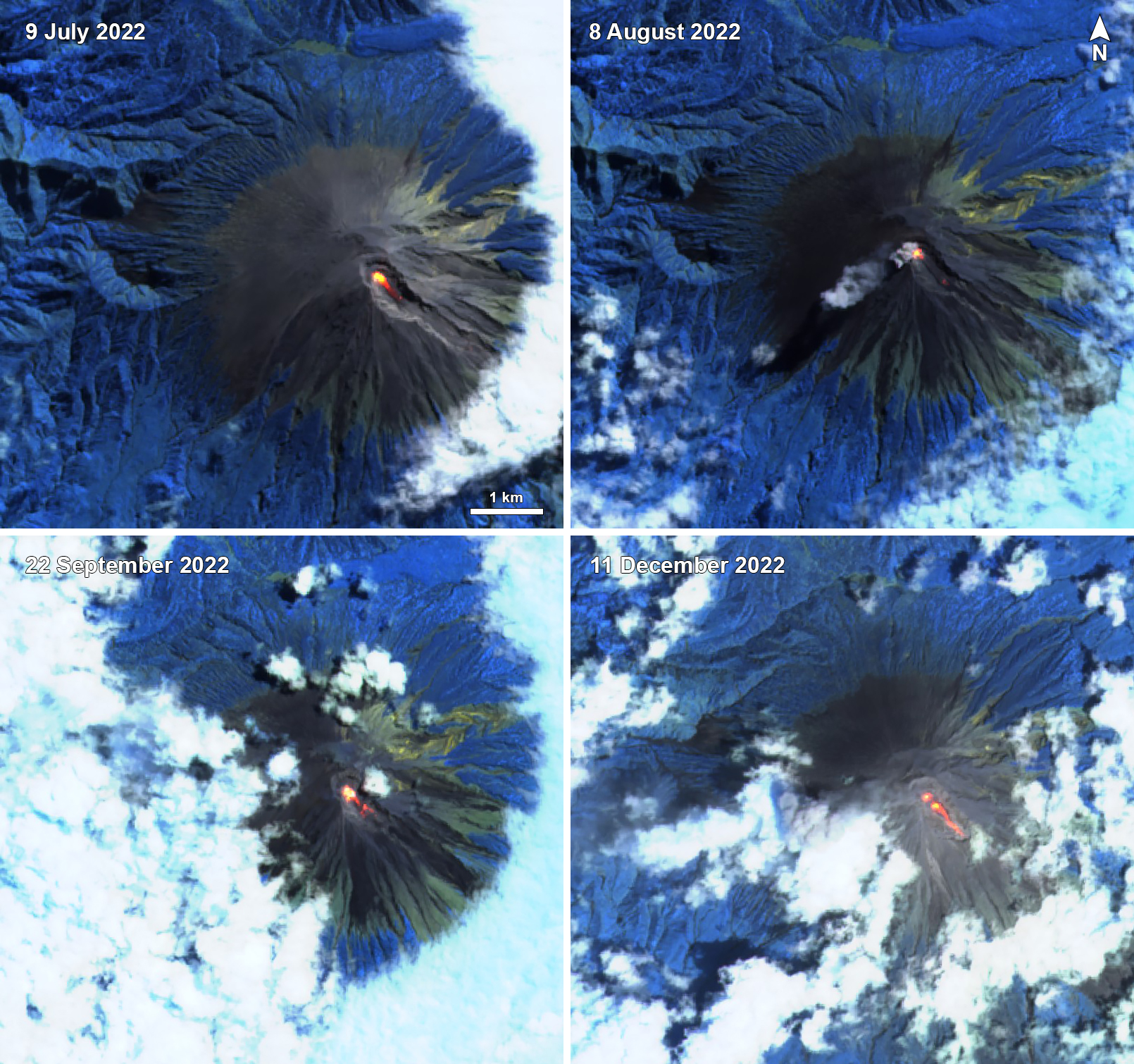 |
Figure 82. A strong thermal anomaly (bright yellow-orange) in the summit crater of Semeru was visible in these infrared satellite images taken on 9 July 2022 (top left), 8 August 2022 (top right), 22 September 2022 (bottom left), and 11 December 2022 (bottom right). Each of these anomalies extended down the SE flank from the summit crater. On 8 August a small ash plume was also visible accompanying the thermal activity. Images use “Atmospheric penetration” rendering (bands 12, 11, 8a). Courtesy of Sentinel Hub Playground. |
Geological Summary. Semeru, the highest volcano on Java, and one of its most active, lies at the southern end of a volcanic massif extending north to the Tengger caldera. The steep-sided volcano, also referred to as Mahameru (Great Mountain), rises above coastal plains to the south. Gunung Semeru was constructed south of the overlapping Ajek-ajek and Jambangan calderas. A line of lake-filled maars was constructed along a N-S trend cutting through the summit, and cinder cones and lava domes occupy the eastern and NE flanks. Summit topography is complicated by the shifting of craters from NW to SE. Frequent 19th and 20th century eruptions were dominated by small-to-moderate explosions from the summit crater, with occasional lava flows and larger explosive eruptions accompanied by pyroclastic flows that have reached the lower flanks of the volcano.
Information Contacts: Pusat Vulkanologi dan Mitigasi Bencana Geologi (PVMBG, also known as Indonesian Center for Volcanology and Geological Hazard Mitigation, CVGHM), Jalan Diponegoro 57, Bandung 40122, Indonesia (URL: http://www.vsi.esdm.go.id/); MAGMA Indonesia, Kementerian Energi dan Sumber Daya Mineral (URL: https://magma.esdm.go.id/v1); Badan Nasional Penanggulangan Bencana (BNPB), National Disaster Management Agency, Graha BNPB - Jl. Scout Kav.38, East Jakarta 13120, Indonesia (URL: http://www.bnpb.go.id/); MIROVA (Middle InfraRed Observation of Volcanic Activity), a collaborative project between the Universities of Turin and Florence (Italy) supported by the Centre for Volcanic Risk of the Italian Civil Protection Department (URL: http://www.mirovaweb.it/); Hawai'i Institute of Geophysics and Planetology (HIGP) - MODVOLC Thermal Alerts System, School of Ocean and Earth Science and Technology (SOEST), Univ. of Hawai'i, 2525 Correa Road, Honolulu, HI 96822, USA (URL: http://modis.higp.hawaii.edu/); Sentinel Hub Playground (URL: https://www.sentinel-hub.com/explore/sentinel-playground); National Public Radio (NPR) (URL: https://www.npr.org/2021/12/05/1061611299/indonesia-volcano-eruption-java-mount-semeru).