Report on Karangetang (Indonesia) — January 2023

Bulletin of the Global Volcanism Network, vol. 48, no. 1 (January 2023)
Managing Editor: Edward Venzke.
Edited by Kadie L. Bennis.
Karangetang (Indonesia) Weak thermal activity and gas-and-steam emissions during July-December 2022
Please cite this report as:
Global Volcanism Program, 2023. Report on Karangetang (Indonesia) (Bennis, K.L., and Venzke, E., eds.). Bulletin of the Global Volcanism Network, 48:1. Smithsonian Institution.
Karangetang
Indonesia
2.781°N, 125.407°E; summit elev. 1797 m
All times are local (unless otherwise noted)
Karangetang (also known as Api Siau), at the northern end of the island of Siau, Indonesia, contains five summit craters along a N-S line. More than 40 eruptions have been recorded since 1675; twentieth-century eruptions have included frequent explosive activity, sometimes accompanied by pyroclastic flows and lahars. Lava dome growth has occurred in the summit craters and collapses of lava flow fronts have produced pyroclastic flows. The two active summit craters are Kawah Dua (the N crater) and Kawah Utama (the S crater, also referred to as the “Main Crater”). The most recent eruption began in late November 2018 and has more recently consisted of intermittent white-and-gray gas-and-steam plumes and summit crater incandescence (BGVN 47:07). This report covers activity during July through December 2022, characterized by crater incandescence and near daily white gas-and-steam emissions, based on reports from Pusat Vulkanologi dan Mitigasi Bencana Geologi (PVMBG, also known as CVGHM, or the Center of Volcanology and Geological Hazard Mitigation), MAGMA Indonesia, and satellite data.
Relatively low activity during the reporting period was mainly characterized by almost daily white, and less frequently gray, gas-and-steam emissions that rose 25-200 m above the summit (figure 57). Incandescence from the S crater on 9 November and from both the N and S craters on 14 November was visible in satellite images. MIROVA (Middle InfraRed Observation of Volcanic Activity) analysis of MODIS satellite data showed weak-to-moderate power thermal anomalies during August through mid-December 2022 (figure 58). There was only one small anomaly detected during early July. By later August, thermal activity began to increase in both frequency and power, which peaked during late September and then began to decline. Anomalies were then lower in power and less frequent during October through mid-December. A thermal anomaly was visible in Sentinel-2 infrared satellite imagery in the N summit crater throughout the reporting period, occasionally accompanied by gas-and-steam emissions (figure 59). A weaker anomaly was visible in the S summit crater at least on 17 July, 31 August, 15 September, 15 October, and 4 December.
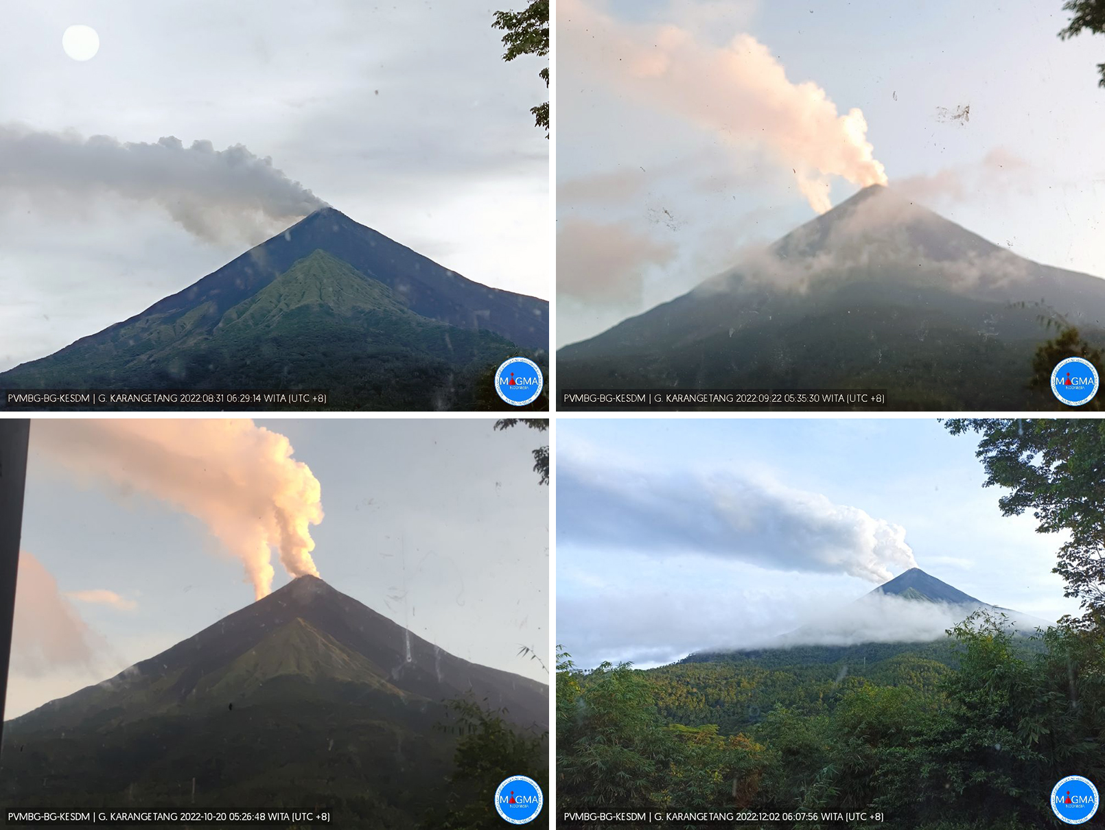 |
Figure 57. Webcam images of Karangetang showing white-to-gray plumes rising above both summit craters on 31 August 2022 (top left), 22 September 2022 (top right), 20 October 2022 (bottom left), and 2 December 2022 (bottom right). Courtesy of MAGMA Indonesia. |
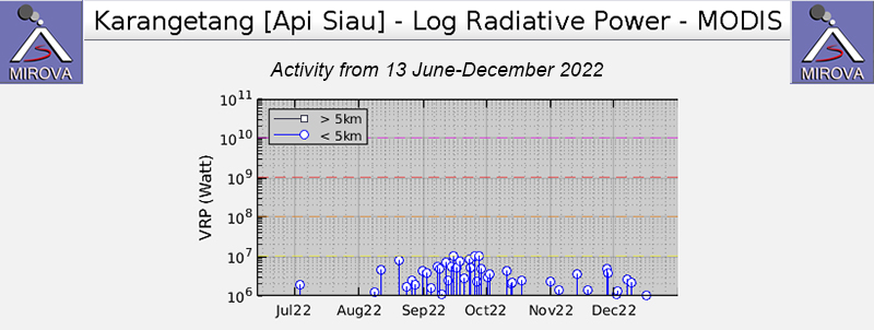 |
Figure 58. Weak-to-moderate power thermal anomalies were detected in the summit area of Karangetang during August through mid-December 2022 as recorded by this MIROVA graph (Log Radiative Power). Only a single low-power anomaly was detected during early July. There was a gradual increase in both power and frequency of anomalies during September, which then had declined by the end of the month. Courtesy of MIROVA. |
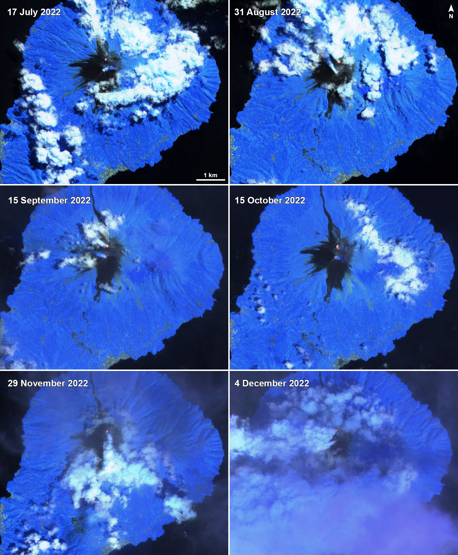 |
Figure 59. A small thermal anomaly (yellow-orange) was visible at the N summit crater at Karangetang on 17 July 2022 (top left), 31 August 2022 (top right), 15 September 2022 (middle left), 15 October 2022 (middle right), 29 November 2022 (bottom left), and 4 December 2022 (bottom right). A weaker anomaly was also detected in the S summit crater during these dates, except on 29 November due to cloud cover. Gas-and-steam emissions were occasionally observed from both summit craters. Images using “Atmospheric penetration” rendering (bands 12, 11, 8a). Courtesy of Sentinel Hub Playground. |
Geological Summary. Karangetang (Api Siau) volcano lies at the northern end of the island of Siau, about 125 km NNE of the NE-most point of Sulawesi. The stratovolcano contains five summit craters along a N-S line. It is one of Indonesia's most active volcanoes, with more than 40 eruptions recorded since 1675 and many additional small eruptions that were not documented (Neumann van Padang, 1951). Twentieth-century eruptions have included frequent explosive activity sometimes accompanied by pyroclastic flows and lahars. Lava dome growth has occurred in the summit craters; collapse of lava flow fronts have produced pyroclastic flows.
Information Contacts: Pusat Vulkanologi dan Mitigasi Bencana Geologi (PVMBG, also known as Indonesian Center for Volcanology and Geological Hazard Mitigation, CVGHM), Jalan Diponegoro 57, Bandung 40122, Indonesia (URL: http://www.vsi.esdm.go.id/); MAGMA Indonesia, Kementerian Energi dan Sumber Daya Mineral (URL: https://magma.esdm.go.id/v1); MIROVA (Middle InfraRed Observation of Volcanic Activity), a collaborative project between the Universities of Turin and Florence (Italy) supported by the Centre for Volcanic Risk of the Italian Civil Protection Department (URL: http://www.mirovaweb.it/); Sentinel Hub Playground (URL: https://www.sentinel-hub.com/explore/sentinel-playground).