Report on Sangay (Ecuador) — March 2023

Bulletin of the Global Volcanism Network, vol. 48, no. 3 (March 2023)
Managing Editor: Edward Venzke.
Edited by Kadie L. Bennis.
Sangay (Ecuador) Daily explosions, incandescent block avalanches, lava flows, and ash plumes during September 2022-February 2023
Please cite this report as:
Global Volcanism Program, 2023. Report on Sangay (Ecuador) (Bennis, K.L., and Venzke, E., eds.). Bulletin of the Global Volcanism Network, 48:3. Smithsonian Institution.
Sangay
Ecuador
2.005°S, 78.341°W; summit elev. 5286 m
All times are local (unless otherwise noted)
Eruptions recorded since 1628 CE from Sangay, the southernmost of Ecuador’s volcanoes, have been characterized by pyroclastic flows, lava flows, ash plumes, and lahars. The current eruption began in March 2019 and has more recently consisted of daily explosions, avalanches, ash plumes, and crater incandescence (BGVN 47:09). This report covers activity during September 2022 through February 2023 and describes similar events of daily explosions, incandescent avalanches, lava flows, and ash plumes, based on information from Ecuador's Instituto Geofísico, Escuela Politécnica Nacional (IG-EPN), Servicio Nacional de Gestión de Riesgos y Emergencias (SNGRE), the Washington Volcanic Ash Advisory Center (VAAC), and various satellite data.
During September 2022 through February 2023, IG-EPN reported daily explosions, gas-and-steam and ash plumes that rose as high as 8.3 km above the crater, and frequent crater incandescence, often accompanied by incandescent block avalanches of material descending the flanks of the volcano. The highest ash plume occurred on 4 November and drifted NW, W, and SW. Explosions occurred nearly every day, ranging from 3-2,040, the most of which occurred on 4 October (figure 143). The average number of explosions was 563, the highest average number of explosions was 950, which occurred during December 2022 (table 12).
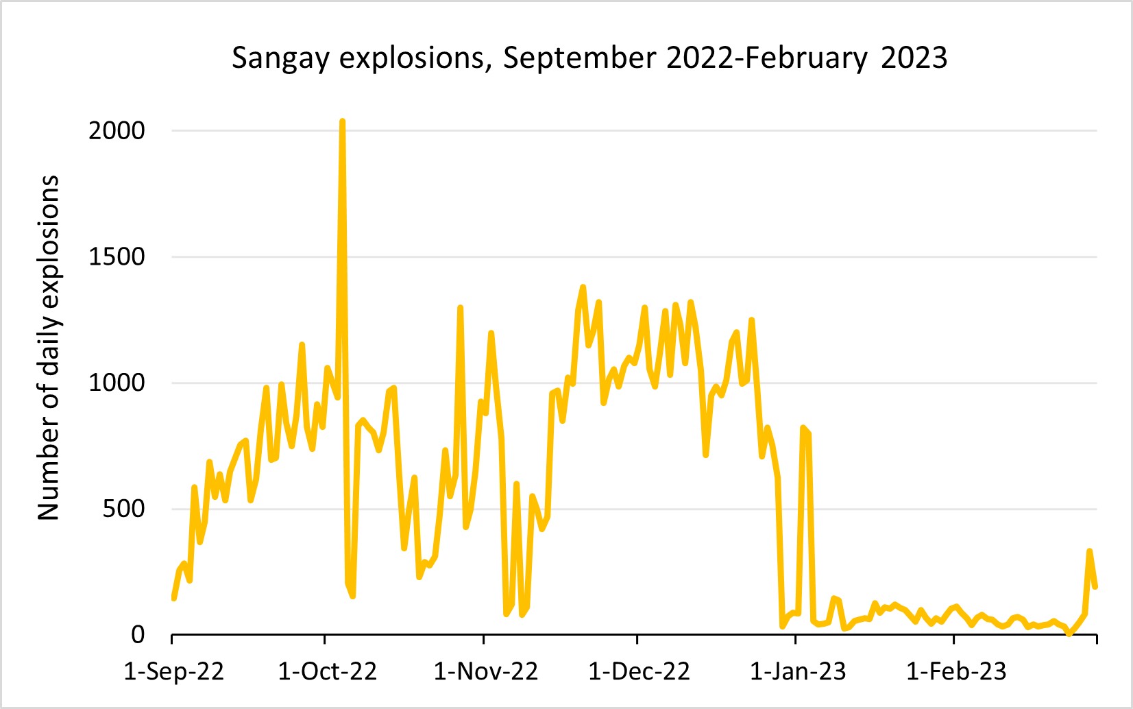 |
Figure 143. Graph showing the number of daily explosions at Sangay during September 2022 through February 2023. The number of explosions markedly decreased during early January 2023 and remained relatively low through February 2023. Data courtesy of IG-EPN (September 2022-February 2023 daily reports). |
Table 12. Monthly summary of explosions and plume heights recorded at Sangay during September 2022 through February 2023. Data courtesy of IG-EPN (September 2022-February 2023 daily reports).
| Month | Average number of explosions per day | Max plume height above the crater rim (m) |
| Sep 2022 | 662 | 2,000 |
| Oct 2022 | 696 | 2,500 |
| Nov 2022 | 838 | 8,300 |
| Dec 2022 | 950 | 2,500 |
| Jan 2023 | 125 | 2,500 |
| Feb 2023 | 68 | 2,000 |
During September, activity consisted of 146-1,152 daily explosions and gas-and-ash emissions that rose as high as 2 km above the summit crater during 12-13, 18-24, and 29-30 September and drifted SW, W, WNW, NW, N, and NE. Seismicity consisted of near-daily long-period (LP) and emission tremor (TRE) events. According to the Washington VAAC, ash emissions rose 500-2,700 m above the crater rim and drifted SW, WSW, W, NW, S, and N. During 1-2 September crater incandescence was visible, accompanied by blocks that rolled down the E flank. During the afternoon and night of 14-15 September incandescent ejecta was observed. Strombolian activity and crater incandescence was visible during the night and early morning during 17-18 September (figure 144). Continuous gas-and-ash emissions rose 1.5 km above the summit and drifted W in the morning. Light ashfall was reported in Cebadas, and stronger ashfall was detected in Rayoloma during 18-19 September; both towns are located to the NW of the volcano. During 22-23 September ash emissions rose 1 km above the crater rim and drifted W, resulting in ashfall in Chauzán in the Chimborazo province.
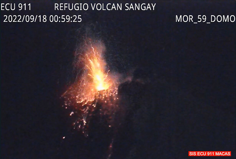 |
Figure 144. Webcam image showing incandescent material ejected above Sangay’s crater at 0059 on 18 September 2022. Courtesy of IG-EPN Daily report. |
Activity persisted during October, with 154-2,040 daily explosions, occasional crater incandescence, and gas-and-ash emissions rising as high as 2.5 km above the crater during 26-27 October that drifted W, N, NW, SW, and SE. The Washington VAAC reported that ash emissions rose 570-2,370 m above the crater rim and drifted W, SW, NW, SE, N, SSW, NE, and E. During 2-5 October several explosions were accompanied by incandescent blocks descending the SE flank. Nighttime incandescence was intermittently visible in the upper part of the volcano. During 11-17, 19-21, and 24-27 October incandescent material descended the SE flank. A collapse of the lava flow front generated a small pyroclastic flow that descended the upper part of the SE drainage during 12-13 October. According to GOES-16 satellite images, an ash cloud was detected during the early morning of 14 October that rose 2,370 m above the crater and drifted W. There was a report of ashfall in Guamote as a result. During the night of 18-19 October summit crater incandescence was visible and a lava flow traveled down the SE flank. A lava flow was reported descending the SE flank during 22-23 October. During the night of 25 October strong incandescence was visible in the crater accompanying a lava flow on the SE flank. In the early morning, reports of loud noises were reported in Salitre and Naranjito, which IG noted was likely associated with the explosive activity. Early morning crater incandescence on 29 October was accompanied by a continuous ash emission that rose 1 km above the crater rim and drifted NW. Slight ashfall was observed in Huamboya Canton in the Morona Santiago province.
There were 80-1,380 daily explosions detected during November, in addition to LP and TRE-type events, gas-and-ash emissions that rose as high as 8.3 km above the crater and drifted generally W and NW, and nighttime crater incandescence. According to the Washington VAAC, gas-and-ash emissions rose 570-3,000 m above the crater and drifted in multiple directions. During 31 October to 1 November crater incandescence was accompanied by incandescent avalanches of material along the SE flank and some ashfall in nearby towns. According to a GOES-16 satellite image, an ash cloud was visible starting at 0520 on 4 November, and around 0700 pyroclastic flows descended the Volcán drainage on the SE flank (figure 131). By 0840 the ash plumes had intensified, rising to a height of 8.3 km above the crater and drifting NW, W, and SW. Light-to-moderate ashfall was recorded in the cities of Riobamba, Guamote, Colta, Alausí, Pallatanga, Chambo, and Chunchi during 3-4 November. During 4-5 November pyroclastic flows traveled along the Volcán drainage (figure 145). An ash plume rose 3 km above the crater and drifted NW, resulting in moderate ashfall in Chimborazo, Bolivar, and Los Rios.
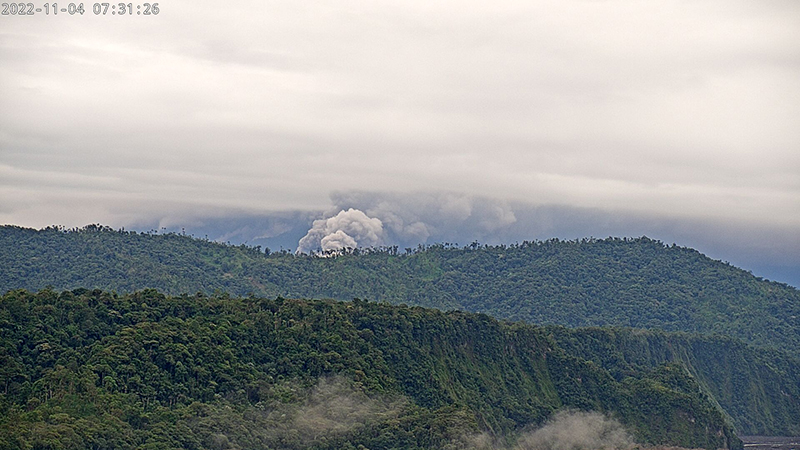 |
Figure 145. Webcam image showing pyroclastic flows descending the SE flank of Sangay during the morning of 4 November 2022. Courtesy of IG-EPN Daily report. |
SNGRE reported that on 9 November a moderate amount of ash fell in Zuñac, in the province of Morona Santiago. During the night and early morning of 9-10 November when the volcano cleared for short periods, gas-and-ash emissions, explosions, and crater incandescence were observed, accompanied by an incandescent avalanche of material descending the SE flank. Crater incandescence and an avalanche of material were also visible during clear weather, moving down the SE flank during 10-14, 17-23, and 26-29 November. On 16 November at 0200 the seismic station recorded seismic signals that corresponded to lahars, though cloudy weather obscured views of the volcano. Heavy rain was reported during 17-18 November which resulted in small mud and debris flows down the SE flank. During the night of 21 November crater incandescence was observed in addition to a lava flow that traveled down the SE flank. On 24 November incandescence was recorded in the upper part of the volcano in the early morning, accompanied by pyroclastic flows. An active lava flow was reported on the SE flank during the night and early morning of 25-26 November. Nighttime crater incandescence and pyroclastic flows on the E flank on 29 November.
Activity during December consisted of 34-1,320 daily explosions, gas-and-ash emissions that rose as high as 2.5 km above the crater during 30 November-1 December and 3-4 December and drifted SE, NNE, NE, W, SW, and NW and seismicity consisting of LP and TRE-type events. According to the Washington VAAC, satellite-based images showed gas-and-ash emissions rising to 570-2,700 m altitude and drifting in different directions. Nighttime and early morning crater incandescence was often visible in clear weather, sometimes accompanied by incandescent block avalanches. During 30 November-1 December, 12-15, and 17-18 December an active lava flow was detected on the SE flank of the volcano. During 1-2 and 5-8 December a pyroclastic flow was observed descending the SE flank. During 28-29 December light ashfall was reported in Cebadas.
During January 2023 activity was often obscured due to cloud cover and the number of daily explosions notably decreased; there were 25-824 daily explosions recorded. Gas-and-ash emissions rose as high as 2.5 km above the crater during 16-17 January and drifted in multiple directions (figure 146). The Washington VAAC reported that gas-and-ash emissions rose 570-1,770 m above the crater and drifted SW, WNW, N, NW, W, SE, S, and NE. Crater incandescence was intermittently visible on clear weather days. During the night and early morning of 9-11 January, a lava flow was observed on the SE flank. An incandescent avalanche of material was visible on the SE flank during 21-22 January.
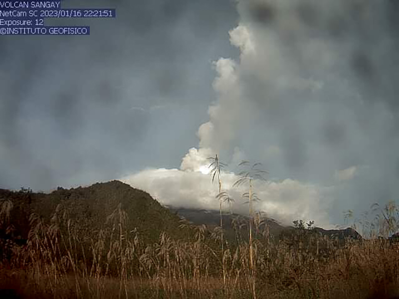 |
Figure 146. Webcam image of a white gas-and-ash plume rising 2.5 km above the crater of Sangay on 16 January 2023. The dark spots on the image is material on the camera lens. Courtesy of IG-EPN Daily report. |
Low activity continued during February, consisting of 3-333 daily explosions. TRE events continued to be detected throughout the month. The Washington VAAC reported that ash emissions rose 500-1,800 m above the crater and drifted NE, S, N, NW, W, SW, and SE. During 14-15 February crater incandescence was visible and an active lava flow traveled 500 m below the summit on the SE flank. During 18-19 November incandescent material rolled down the SE flank. During the night of 21-22 February crater incandescence was accompanied by a lava flow on the S flank. Gas-and-ash emissions rose 1.2 km above the crater and drifted S and NW, based on satellite images during 21-24 February. During 26-28 February continuous ash emissions rose 1.5-2 km above the crater and drifted SW and W.
Satellite data. Thermal activity was consistently strong throughout the reporting period due to crater incandescence, block avalanches, and lava flows primarily affecting the SE flank. This activity was detected by the MIROVA hotspot detection system (figure 147) and the MODVOLC Thermal Alerts system, which detected 108 hotspots. Sentinel-2 infrared satellite imagery showed incandescence block avalanches and lava flows descending the SE flank and crater incandescence (figure 148). Frequent, strong sulfur dioxide plumes were captured by the TROPOMI instrument on the Sentinel-5P satellite; many of these plumes exceeded 2 Dobson Units (DUs) and drifted in different directions (figure 149).
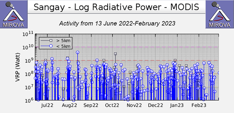 |
Figure 147. Thermal activity at Sangay was relatively strong throughout the reporting period of September 2022-February 2023 due to frequent crater incandescence, incandescent block avalanches, and lava flows on the flanks. Courtesy of MIROVA. |
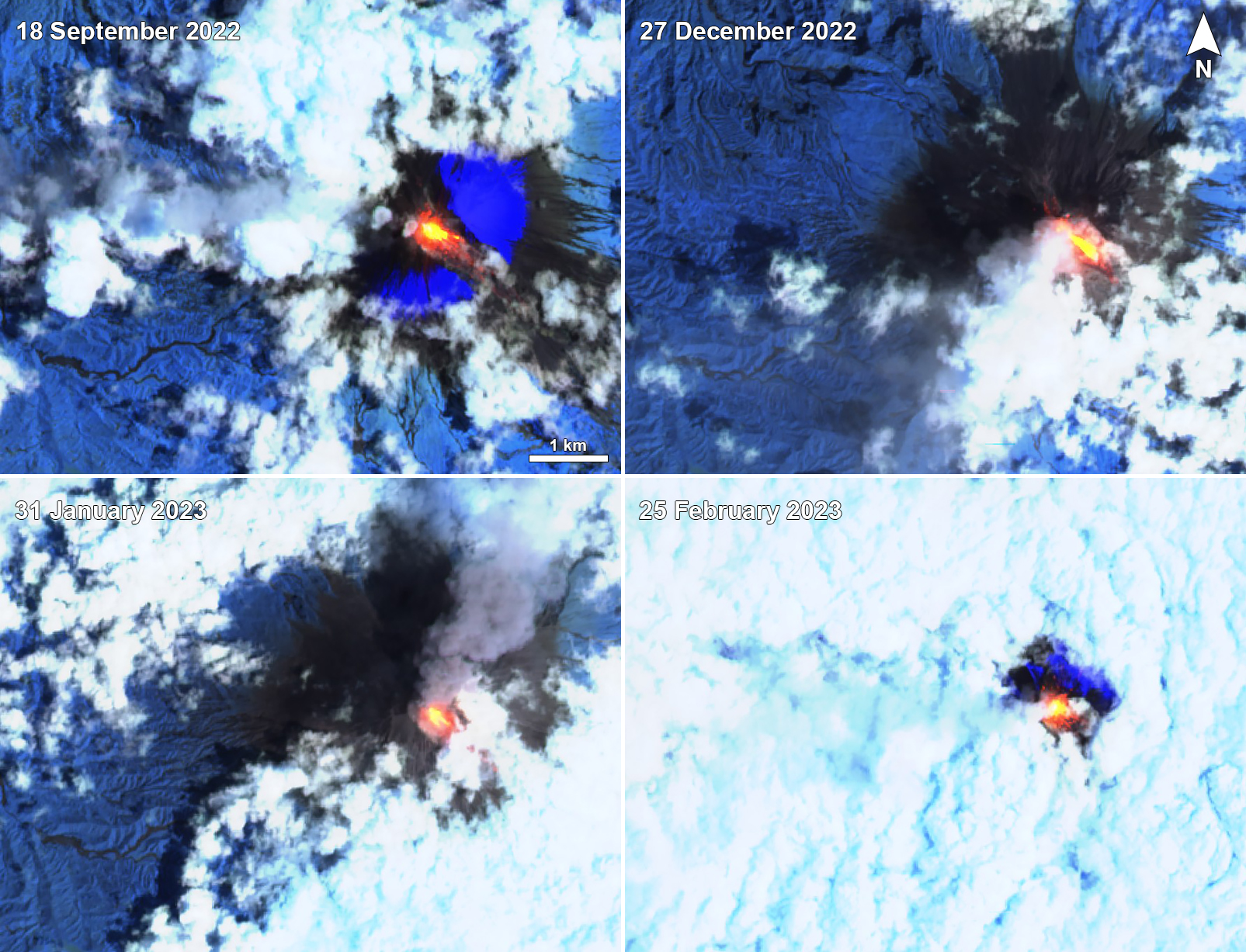 |
Figure 148. Strong thermal activity was visible in these Sentinel-2 infrared satellite images of Sangay on 18 September 2022 (top left), 27 December 2022 (top right), 31 January 2023 (bottom left), and 25 February 2023 (bottom right). Incandescent block avalanches and lava flows primarily descended the SE flank, as shown here. Images use “Atmospheric penetration” rendering (bands 12, 22, 8A). Courtesy of Sentinel Hub Playground. |
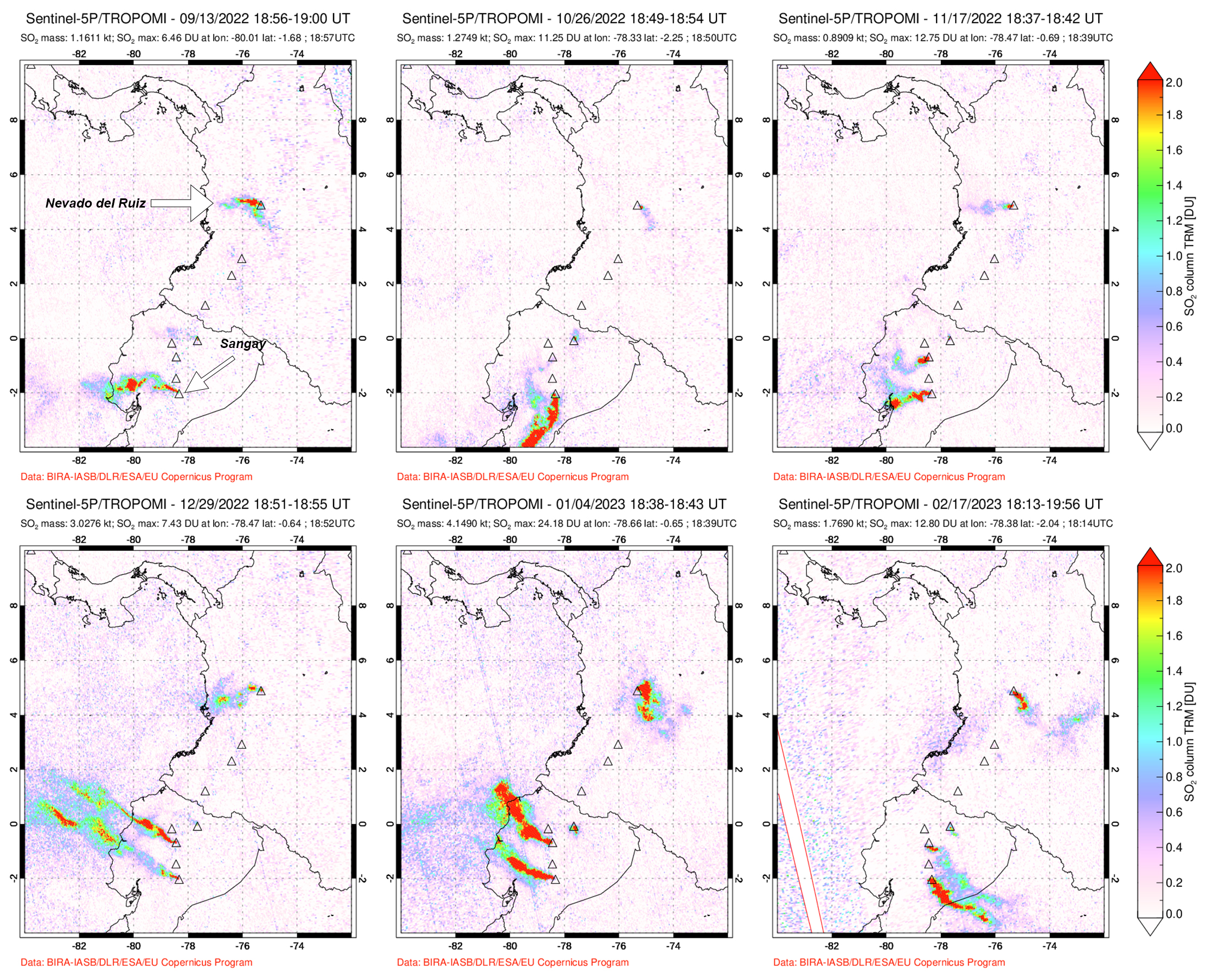 |
Figure 149. Strong sulfur dioxide plumes from Sangay were frequent throughout the reporting period, as shown here on 13 September 2022 (top left), 26 October 2022 (top middle), 17 November 2022 (top right), 29 December 2022 (bottom left), 4 January 2023 (bottom middle), and 17 February 2023 (bottom right). Each of these plumes exceeded 2 Dobson Units (DUs) and drifted in different directions. Sangay is located toward the bottom of the satellite images with sulfur dioxide plumes; Colombia’s Nevado del Ruiz is the topmost symbol that also frequently emits sulfur dioxide. Data is from the TROPOMI instrument on the Sentinel-5P satellite. Courtesy of NASA Global Sulfur Dioxide Monitoring Page. |
Geological Summary. The isolated Sangay volcano, located east of the Andean crest, is the southernmost of Ecuador's volcanoes and its most active. The steep-sided, glacier-covered, dominantly andesitic volcano grew within the open calderas of two previous edifices which were destroyed by collapse to the east, producing large debris avalanches that reached the Amazonian lowlands. The modern edifice dates back to at least 14,000 years ago. It towers above the tropical jungle on the east side; on the other sides flat plains of ash have been eroded by heavy rains into steep-walled canyons up to 600 m deep. The earliest report of an eruption was in 1628. Almost continuous eruptions were reported from 1728 until 1916, and again from 1934 to the present. The almost constant activity has caused frequent changes to the morphology of the summit crater complex.
Information Contacts: Instituto Geofísico, Escuela Politécnica Nacional (IG-EPN), Casilla 17-01-2759, Quito, Ecuador (URL: http://www.igepn.edu.ec/); Servicio Nacional de Gestion de Riesgos y Emergencias (SNGRE), Samborondón, Ecuador (URL: https://www.gestionderiesgos.gob.ec/); Washington Volcanic Ash Advisory Center (VAAC), Satellite Analysis Branch (SAB), NOAA/NESDIS OSPO, NOAA Science Center Room 401, 5200 Auth Rd, Camp Springs, MD 20746, USA (URL: www.ospo.noaa.gov/Products/atmosphere/vaac, archive at: http://www.ssd.noaa.gov/VAAC/archive.html); MIROVA (Middle InfraRed Observation of Volcanic Activity), a collaborative project between the Universities of Turin and Florence (Italy) supported by the Centre for Volcanic Risk of the Italian Civil Protection Department (URL: http://www.mirovaweb.it/); Hawai'i Institute of Geophysics and Planetology (HIGP) - MODVOLC Thermal Alerts System, School of Ocean and Earth Science and Technology (SOEST), Univ. of Hawai'i, 2525 Correa Road, Honolulu, HI 96822, USA (URL: http://modis.higp.hawaii.edu/); NASA Global Sulfur Dioxide Monitoring Page, Atmospheric Chemistry and Dynamics Laboratory, NASA Goddard Space Flight Center (NASA/GSFC), 8800 Greenbelt Road, Goddard MD 20771, USA (URL: https://so2.gsfc.nasa.gov/); Sentinel Hub Playground (URL: https://www.sentinel-hub.com/explore/sentinel-playground).