Report on Krafla (Iceland) — September 1976

Natural Science Event Bulletin, vol. 1, no. 12 (September 1976)
Managing Editor: David Squires.
Krafla (Iceland) Increased seismicity from early July through mid-September
Please cite this report as:
Global Volcanism Program, 1976. Report on Krafla (Iceland) (Squires, D., ed.). Natural Science Event Bulletin, 1:12. Smithsonian Institution. https://doi.org/10.5479/si.GVP.NSEB197609-373080
Krafla
Iceland
65.715°N, 16.728°W; summit elev. 800 m
All times are local (unless otherwise noted)
More than 2 m of subsidence occurred in a 2-3 km2 roughly circular area, immediately E of Leirhnjúkur (about 4 km W of Krafla; figure 1), between 20 December 1975, the first day of a minor eruption of Leirhnjúkur, and the end of January, 1976. Subsidence was followed by uplift of about 6.5 mm/day, beginning in February and continuing to the present (figure 2).
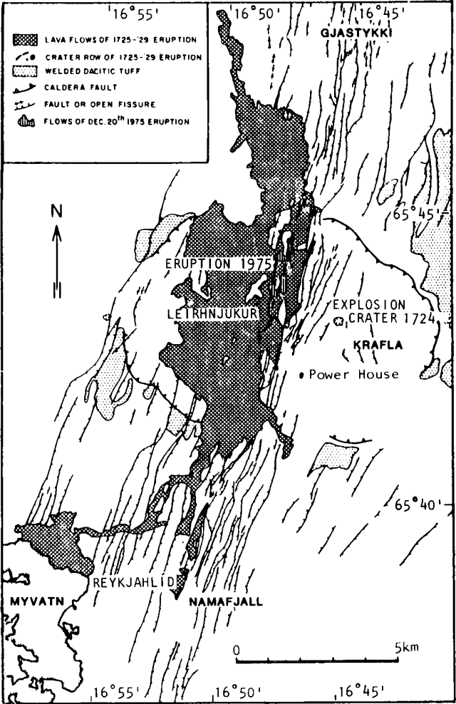 |
Figure 1. Outline geologic map of Krafla caldera and the associated fault swarm. Note that Leirhnjúkur is a feature within tha caldera and that Lake Mývatn intercepts a portion of the fault swarm. From Björnsson and others (1977). |
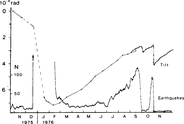 |
Figure 2. Deformation and seismicity at Krafla caldera, November 1975-November 1976. A) N-S component of tilt at the Krafla power house; increasing numbers mean tilt down towards the N. B) 5-day running average of the number of earthquakes per day recorded at the seismic station near Reykjahlíd. Tilt was measured by precision levelling until August 1976, after which a conventional "wet" titlmeter (79 m base) was used. From Björnsson and others (1977). |
The area of subsidence and subsequent uplift is thought to be underlain by a magma chamber about 3 km in diameter with its roof at about 3 km depth. Assuming that the cause of uplift was flow of magma from below into the chamber, velocity of flow was of the order of 4-4.5 m3/s.
The number of earthquakes per day in the area (figure 2) has increased considerably since early July, although remaining an order of magnitude less than the 1500/day experienced in January, then decreased rapidly in the last days of September.
Reference. Björnsson, A., Saemundsson, K., Einarsson, P., Tryggvason, E., and Grönvold, K., 1977, Current rifting episode in north Iceland: Nature, v. 266, p. 318-323.
Geological Summary. The Krafla volcanic system in the Northern Volcanic Zone (NVZ) of Iceland is about 100 km long, consisting of a fissure swarm and a central volcano with a 7 x 9 km caldera formed about 110,000 years ago that deposited a rhyolitic welded tuff. It has been moderately active in the Holocene, over three distinct eruptive periods; the current one has lasted about 2,800 years with six volcano-tectonic episodes, each with one or more basaltic fissure eruptions. Lava volumes (DRE) have been in the 0.1-1 km3 range. The Hverfjall and Ludent tuff rings east of Myvatn were erupted along the fissure system. Myvatn lake formed during the eruption of the older Laxarhraun lava flow from the Ketildyngja shield volcano of the Fremrinamur volcanic system about 3,800 years before present (BP); The present Myvatn lake is constrained by the roughly 2,000 years BP younger Laxarhraun lava flow from the Krafla volcanic system. The abundant pseudocraters that form a prominent part of the Myvatn landscape were created when the younger Laxarhraun lava flow entered the lake. The last eruption took place in 1975-1984 CE when nine small basaltic fissure eruptions produced 0.25 km3 of lava.
Information Contacts: H. Sigtryggsson, Icelandic Meteorological Office.