Report on Manam (Papua New Guinea) — April 1977

Natural Science Event Bulletin, vol. 2, no. 4 (April 1977)
Managing Editor: David Squires.
Manam (Papua New Guinea) Minor eruptive activity from two craters since mid-February
Please cite this report as:
Global Volcanism Program, 1977. Report on Manam (Papua New Guinea) (Squires, D., ed.). Natural Science Event Bulletin, 2:4. Smithsonian Institution. https://doi.org/10.5479/si.GVP.NSEB197704-251020
Manam
Papua New Guinea
4.08°S, 145.037°E; summit elev. 1807 m
All times are local (unless otherwise noted)
A minor eruption has been in progress from Main and Southern craters (figure 1) since mid-February. Weak intermittent lava fountaining has been observed 7 times at Southern crater, while brief phases of ash ejection, and on one occasion lava fountaining, were seen at Main crater during February and March. Low-level volcanic tremor has been recorded, but no significant tilt effects preceded the eruption.
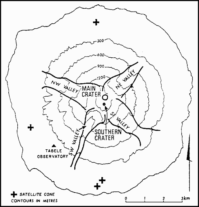 |
Figure 1. Sketch map of Manam Island, after Palfreyman and Cooke (1976). |
Volcano-seismic events normally occur at the rate of about 1 per minute beneath Manam. Minor eruptive phenomena occur intermittently between major eruptions (such as 1974-1975). [2:4 erred in adding that these phenomena were usually confined to Main Crater.]
Reference. Palfreyman, W.D., and Cooke, R.J.S., 1976, Eruptive history of Manam volcano, Papua New Guinea, in Johnson, R.W. (ed.), Volcanism in Australasia: Elsevier, Amsterdam, p. 117-131.
Geological Summary. The 10-km-wide island of Manam, lying 13 km off the northern coast of mainland Papua New Guinea, is one of the country's most active volcanoes. Four large radial valleys extend from the unvegetated summit of the conical basaltic-andesitic stratovolcano to its lower flanks. These valleys channel lava flows and pyroclastic avalanches that have sometimes reached the coast. Five small satellitic centers are located near the island's shoreline on the northern, southern, and western sides. Two summit craters are present; both are active, although most observed eruptions have originated from the southern crater, concentrating eruptive products during much of the past century into the SE valley. Frequent eruptions, typically of mild-to-moderate scale, have been recorded since 1616. Occasional larger eruptions have produced pyroclastic flows and lava flows that reached flat-lying coastal areas and entered the sea, sometimes impacting populated areas.
Information Contacts: R. Cooke, RVO.