Report on Akutan (United States) — May 1977
Natural Science Event Bulletin, vol. 2, no. 5 (May 1977)
Managing Editor: David Squires.
Akutan (United States) Ash eruptions observed in early May
Please cite this report as:
Global Volcanism Program, 1977. Report on Akutan (United States) (Squires, D., ed.). Natural Science Event Bulletin, 2:5. Smithsonian Institution. https://doi.org/10.5479/si.GVP.NSEB197705-311320
Akutan
United States
54.134°N, 165.986°W; summit elev. 1303 m
All times are local (unless otherwise noted)
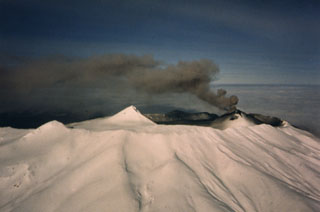
Eruptive activity, reported from this volcano in 1973 and 1974, resumed on 5 May and was continuing four days later. Personnel aboard the USCG Cutter Ironwood observed eruptions of light brown ash clouds about every 15 minutes between 1700 and 2000 on 5 May. The ash blew to the N but only a thin layer was noted on the snow-covered N side of the island. The ash eruptions were separated by periods of white steam emission. Richard Maloney, an airline pilot, saw incandescent ash during an overflight at 1730 on 6 May and more ash eruptions on 7 May. The Ironwood returned to the island at 1900 on 9 May and activity similar to that of 5 May was observed. Villagers on Akutan report sporadic activity since last autumn.
Geological Summary. Akutan contains a 2-km-wide caldera with a large cinder cone in the NE part of the caldera that has been the source of frequent explosive eruptions and occasional lava effusion that covers the caldera floor. An older, largely buried caldera was formed during the late Pleistocene or early Holocene. Two volcanic centers are located on the NW flank. Lava Peak is of Pleistocene age, and a cinder cone lower on the flank produced a lava flow in 1852 that extended the shoreline of the island and forms Lava Point. The 60-365 m deep younger caldera was formed during a major explosive eruption about 1,600 years ago and contains at least three lakes. A lava flow in 1978 traveled through a narrow breach in the north caldera rim almost to the coast. Fumaroles occur at the base of the caldera cinder cone, and hot springs are located NE of the caldera at the head of Hot Springs Bay valley and along the shores of Hot Springs Bay.
Information Contacts: T. Miller, USGS, Anchorage.