Report on Ruapehu (New Zealand) — November 1977

Natural Science Event Bulletin, vol. 2, no. 11 (November 1977)
Managing Editor: David Squires.
Ruapehu (New Zealand) Moderate phreato-magmatic eruption from Crater Lake on 2 November
Please cite this report as:
Global Volcanism Program, 1977. Report on Ruapehu (New Zealand) (Squires, D., ed.). Natural Science Event Bulletin, 2:11. Smithsonian Institution. https://doi.org/10.5479/si.GVP.NSEB197711-241100
Ruapehu
New Zealand
39.28°S, 175.57°E; summit elev. 2797 m
All times are local (unless otherwise noted)
A moderate phreatomagmatic eruption from Crater Lake occurred at 1350 on 2 November, accompanied by a [M 3.4] earthquake. Two eruptive pulses were observed, the second producing an ash cloud that rose 1800 m above the summit before being blown NE.
NZGS personnel inspected the volcano from the air less than 2 hours after the eruption and conducted ground investigations on 5 and 9 November. Airfall tephra was deposited in a narrow zone, extending several km NE of the vent (figure 1). The margins of the deposits consisted of 40-150 mm of normally graded ejecta, ranging in size from coarse lapilli at the base to ash at the surface. Accessory material was estimated to comprise >99% of the deposit, which included a substantial quantity of sulfur spherules and gypsum. Within about 600 m of the vent, numerous impact craters were observed, most 0.15-0.2 m in diameter, cylindrical, and steeply inclined (figure 2). The largest crater in this area was l m in diameter, but a single isolated crater, 5 m in diameter, was discovered 1.2 km from the vent. Craters were formed by dense accessory andesite blocks that were also scattered across the surface of the deposits, accompanied by rare (
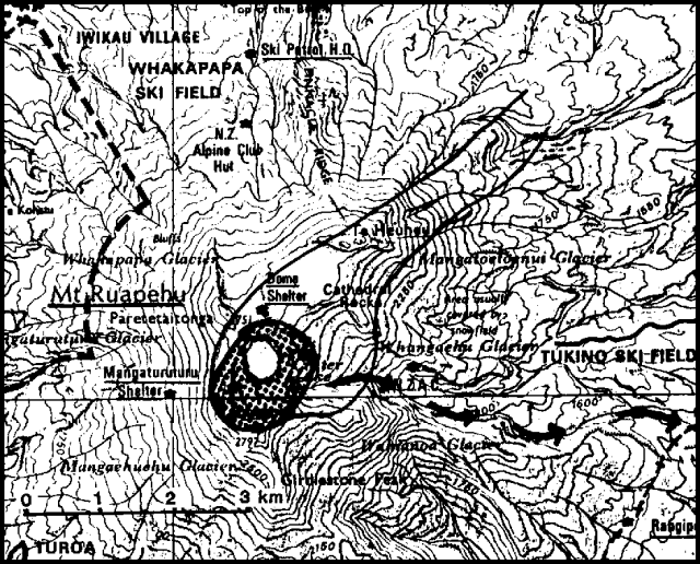 |
Figure 1. Summit region of Mt. Ruapehu, showing area of 2 November 1977 impact craters (stippled) and ash deposits (enclosed by solid line). Crater Lake is 500 m in diameter. Arrows indicate the upper portion of the path of the lahar down the Whangaehu River. Contoured interval is 50 m. |
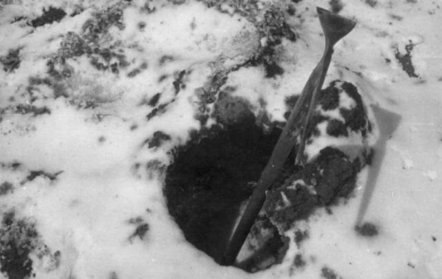 |
Figure 2. Impact crater, northern Crater Lake Basin at Ruapehu, 9 November 1977. Courtesy of NZGS. |
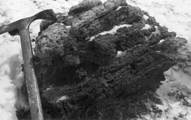 |
Figure 3. Broken face on large breadcrust bomb, revealing scoriaceous interior, Ruapehu Crater Lake Basin, 9 November 1977. Courtesy of NZGS. |
Several months of small-scale phreatic activity in Crater Lake preceded the 2 November event. During the aerial survey, vigorous steam emission was occurring from the lake, which contained a black sulfur slick near its center, indicating convective upwelling. Several small steam eruptions were observed between 4 and 9 November, none of which produced new tephra deposits. The volume of 2 November ejecta is estimated to be at least as great as that of the 1971 phreatomagmatic eruption.
Further Reference. Wood, C.P., 1978, Bombs from the Ruapehu Eruption, 2 November, 1977; New Zealand Volcanological Record, no. 7, p. 39
Geological Summary. Ruapehu, one of New Zealand's most active volcanoes, is a complex stratovolcano constructed during at least four cone-building episodes dating back to about 200,000 years ago. The dominantly andesitic 110 km3 volcanic massif is elongated in a NNE-SSW direction and surrounded by another 100 km3 ring plain of volcaniclastic debris, including the NW-flank Murimoto debris-avalanche deposit. A series of subplinian eruptions took place between about 22,600 and 10,000 years ago, but pyroclastic flows have been infrequent. The broad summait area and flank contain at least six vents active during the Holocene. Frequent mild-to-moderate explosive eruptions have been recorded from the Te Wai a-Moe (Crater Lake) vent, and tephra characteristics suggest that the crater lake may have formed as recently as 3,000 years ago. Lahars resulting from phreatic eruptions at the summit crater lake are a hazard to a ski area on the upper flanks and lower river valleys.
Information Contacts: B. Houghton, E. Lloyd, NZGS, Rotorua; P. Otway, NZGS, Wairakei.