Report on Toya (Japan) — November 1977
Natural Science Event Bulletin, vol. 2, no. 11 (November 1977)
Managing Editor: David Squires.
Toya (Japan) Small steam explosion from three new vents on 16 November
Please cite this report as:
Global Volcanism Program, 1977. Report on Toya (Japan) (Squires, D., ed.). Natural Science Event Bulletin, 2:11. Smithsonian Institution. https://doi.org/10.5479/si.GVP.NSEB197711-285030
Toya
Japan
42.544°N, 140.839°E; summit elev. 733 m
All times are local (unless otherwise noted)
Weak emission of white to grayish-white steam from small craters and fissures near Ko-Usu and O-Usu continued through October, reaching a maximum height of 400 m above the vents. Uplift of Ogari-yama [a large block making up most of the 2 km-diameter somma's NE quadrant, that has been uplifted] at the E foot of Ko-Usu since August, continued during October at the rate of about 45 cm/day, while Ko-Usu itself subsided about 40 cm/day. Another [unnamed peak of the uplifting block], about 240 m ENE of Ko-Usu's summit, rose 60 cm/day in October.
A small steam explosion from three new vents began between 0300 and 0400 on 16 November (figure 7) and lasted until about 0930. The explosion, the first from Usu since 14 August, produced a 300-m cloud and was accompanied by rumbling. The new vents (one is 6 m in diameter, the other two about 2 m in diameter) are clustered atop a 25-m-diameter rise at the edge of the unnamed new cryptodome. Several hundred local earthquakes per day continued to be recorded (figure 8).
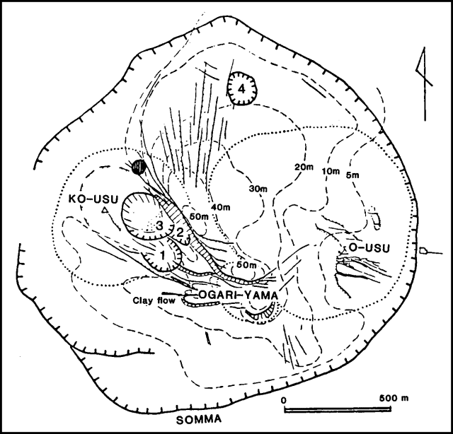 |
Figure 7. Region within Usu's somma. Solid lines are faults and fractures, dashed lines show amount of new uplift as of 23 August, and dotted lines outline pre-existing domes (Ko-Usu, O-Usu, and Ogari-yama). New craters are numbered. The location of the 16 November 1977 vent is shown by a small shaded circle N of vent 3; location was provided by JMA. From Katsui and others, 1978. |
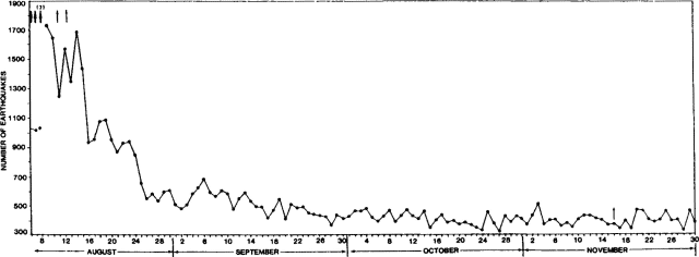 |
Figure 8. Number of seismic events/day, 7 August-30 November 1978, recorded by a JMA seismograph 2.3 km N of the summit of O-Usu. Heavy arrows indicate major explosions, lighter arrows smaller explosions [considered to be phreatic]. Continuous [eruption] tremor, represented by * prevented a [precise] earthquake count on 9 August. Courtesy of JMA. |
Reference. Katsui, Y., Oba, Y. Onuma, K, Suzukuki, T., Kondo, Y., and others, 1978, Preliminary report of the 1977 eruption of Usu volcano: Journal of the Faculty of Science, Hokkaido University, Ser. 4, v. 18, p. 385-408.
Geological Summary. Usuzan, one of Hokkaido's most well-known volcanoes, is a small stratovolcano located astride the southern topographic rim of the 110,000-year-old Toya caldera. The center of the 10-km-wide, lake-filled caldera contains Nakajima, a group of forested Pleistocene andesitic lava domes. The summit of the basaltic-to-andesitic edifice of Usu is cut by a somma formed about 20-30,000 years ago when collapse of the volcano produced a debris avalanche that reached the sea. Dacitic domes erupted along two NW-SE-trending lines fill and flank the summit caldera. Three of these domes, O-Usu, Ko-Usu and Showashinzan, along with seven crypto-domes, were erupted during historical time. The 1663 eruption of Usu was one of the largest in Hokkaido during historical time. The war-time growth of Showashinzan from 1943-45 was painstakingly documented by the local postmaster, who created the first detailed record of growth of a lava dome.
Information Contacts: T. Tiba, National Science Museum, Tokyo; JMA, Tokyo.