Report on Ulawun (Papua New Guinea) — May 1978

Scientific Event Alert Network Bulletin, vol. 3, no. 5 (May 1978)
Managing Editor: David Squires.
Ulawun (Papua New Guinea) Large eruption: lava flow, ash, nuée ardente, and radial vents
Please cite this report as:
Global Volcanism Program, 1978. Report on Ulawun (Papua New Guinea) (Squires, D., ed.). Scientific Event Alert Network Bulletin, 3:5. Smithsonian Institution. https://doi.org/10.5479/si.GVP.SEAN197805-252120
Ulawun
Papua New Guinea
5.05°S, 151.33°E; summit elev. 2334 m
All times are local (unless otherwise noted)
"A new eruption was first observed just after 1900 on 7 May, when intermittent glow was seen at the summit. This rapidly developed into explosions of incandescent lava fragments from the summit crater, which increased in intensity until by 2100-2200 a full-scale eruption was in progress. At this stage, new ejections were visible every few seconds and explosive sounds were prominent; the intensity was probably as strong as that during the peaks of the 1970 and 1973 eruptions.
"Aerial inspections the following morning showed powerful ejections of red incandescent bombs every few seconds, feeding an eruption column 1-1.5 km high. The ash content in the ejections was fairly small, and the eruption column was relatively thin in texture. Only one source was noted and this appeared to be towards the N part of the 1973 `chasm', which had been deepened considerably by collapse sometime between May and July 1976.
"Similar activity continued through the night of 8-9 May, probably with a slight decline in intensity. However, beginning about 0700 on 9 May the vigor of ejections increased and the ash content built up very rapidly, until by mid-afternoon large quantities of black ash were being erupted in a column about 2.5 km high, and ashfall was accumulating rapidly at the downwind coast. A layer about 1 cm thick was deposited in a few hours 12 km WNW of the summit, and the ash plume extended tens of kilometers out to sea. An aerial inspection early 9 May revealed a weak small second vent on the SE side of the summit. This strong phase slackened off noticeably after about 1630 on 9 May.
"One or more nuées ardentes traveled down the SE flank at the peak of this phase, starting at about 1545, but were not directly observed, being on the opposite side of the volcano to the observation post. Fallen trees were visible only at the edges of the extensive area of forest destroyed by the nuées ardentes. The devastation extended 6-7 km from the summit and exhibited several adjoining lobes (figure 1).
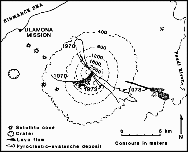 |
Figure 1. Sketch map of Ulawun showing 1970-78 lava flows and pyroclastic avalanche deposits. Contour interval is 400 m. After McKee and others (1981). |
"A spectacular but so far unidentified phenomenon was observed by pilots of two aeroplanes at about 1045 on 9 May, although nothing unusual was noted at that time from the observation post. This had some of the characteristics of both nuées ardentes and lava flows, to judge by the descriptions, and the mountain was [reported] to have split from top to bottom. It is hoped that photographs taken from both planes will assist in interpreting this event.
"Summit activity during the night of 9-10 May was reduced in comparison to that of the previous nights, with much less incandescence, and intermittent spells of inactivity up to 30 seconds long. Little activity was evident by about 0800 on 10 May; rumblings were often heard, but only a thin wispy eruption column was present.
"Later that morning, ash emission again increased strongly, a thick black column of ash was present through 11 May, and additional ashfalls were recorded at the coast. During the night of 10-11 May, incandescent lava fragments were still occasionally ejected from the summit crater, but the next night, only occasional weak glow was noted.
"A morning aerial inspection on the 11th showed that a thick ash column was billowing up rapidly and continuously from virtually the whole area of the summit, although individual projections of dense black ash with little solid content could be seen periodically. No incandescence was visible. A lava flow was active on the lower E flank of the volcano; its source was apparently a radial fissure about 500 m long, some 6 km from the summit and 2,000 m vertically below it, along which a number of individual lava vents could be seen. Some issued lava as brightly incandescent but quiet flows, others as vigorous continuous fountains of bright orange lava estimated (under poor conditions) to be gushing lava to heights of at least 30-40 m. It was thought probable that this fissure had opened sometime the previous day (10 May).
"The lava flow sources remained vigorously active 12-13 May. More than a dozen individual vents were present, five of them fountains. The cumulative effusion rate was probably 100-200 m3/s (provisional estimate), and the lava velocity was about 2-2.5 m/sec near the sources. During this time however, summit explosive activity weakened and eventually ceased in the late afternoon of 13 May. Although ash emission was still fairly strong on the 12th and the morning of the 13th, the ash column was no longer black but a mid-grey/brown color. During the afternoon of the 13th, intermittent periods of only white vapor emission were noted during the final stages of explosive activity.
"By 14 May, the lava flow sources were fewer in number and much weaker; sources higher up the fissure had stopped and only one fountain was still active, at the bottom end of the fissure. Lava flow ceased altogether, probably during the night of 14-15 May, just as the flow front had finished blocking the main channel of the Pandi River (about 11 km from the volcano), diverting it into an existing older channel. Lava had passed less than 50 m from Naisapuna, a hamlet of four houses and the only inhabited spot on the whole E flank, and had cut the only road on that flank (a rough track). Provisionally, the flow may contain 20 x 106 m3 of lava. The lava appears to be basalt, broadly similar to that of the 1970 and 1973 eruptions, although no analyses have yet been carried out.
"A short-period, vertical-component seismograph has been in use at Ulamona Catholic Mission (11 km WNW of Ulawun's summit) since December 1976. Between then and August 1977, a number of brief swarms of B-type volcanic events were recorded. During the last few days of April 1978, a number of barely discernible events, probably of the same kind, were recorded (mostly on 27-29 April) and a few were seen every day until the start of the eruption. Somewhat larger events resembling short bursts of volcanic tremor occurred on 2-3 May. During the few hours before the start of the visible eruption on 7 May, patchy, weak tremor was recorded. This tremor became strong and continuous with the commencement of visible activity, and maximum amplitudes were recorded during the first night. Tremor declined slightly after that and from mid-week, amplitudes fluctuated. Tremor ceased altogether with the end of explosive activity on 13 May. Some large and unusual events were recorded on the 9th and l0th that may be volcanic, but their interpretation is unclear at present."
Further Reference. McKee, C.O., Almond, R.A., Cooke, R.J.S., and Talai, B., 1981, Basaltic pyroclastic avalanches and flank effusion from Ulawun volcano in 1978, in Johnson, R.W. (ed.), Cooke-Ravian Volume of Volcanological Papers: Geological Survey of Papua New Guinea Memoir 10, p. 153-66.
Geological Summary. The symmetrical basaltic-to-andesitic Ulawun stratovolcano is the highest volcano of the Bismarck arc, and one of Papua New Guinea's most frequently active. The volcano, also known as the Father, rises above the N coast of the island of New Britain across a low saddle NE of Bamus volcano, the South Son. The upper 1,000 m is unvegetated. A prominent E-W escarpment on the south may be the result of large-scale slumping. Satellitic cones occupy the NW and E flanks. A steep-walled valley cuts the NW side, and a flank lava-flow complex lies to the south of this valley. Historical eruptions date back to the beginning of the 18th century. Twentieth-century eruptions were mildly explosive until 1967, but after 1970 several larger eruptions produced lava flows and basaltic pyroclastic flows, greatly modifying the summit crater.
Information Contacts: R. Cooke, RVO.