Report on Karkar (Papua New Guinea) — September 1978

Scientific Event Alert Network Bulletin, vol. 3, no. 9 (September 1978)
Managing Editor: David Squires.
Karkar (Papua New Guinea) Volcanic tremor and new thermal activity; explosion sounds and glow
Please cite this report as:
Global Volcanism Program, 1978. Report on Karkar (Papua New Guinea) (Squires, D., ed.). Scientific Event Alert Network Bulletin, 3:9. Smithsonian Institution. https://doi.org/10.5479/si.GVP.SEAN197809-251030
Karkar
Papua New Guinea
4.647°S, 145.976°E; summit elev. 1839 m
All times are local (unless otherwise noted)
"Unusual periodic bands of seismic noise were first recorded at Karkar Observatory on 10 July, and continued virtually unchanged until mid-August, when the amplitude began to increase slowly (figure 1). A strong increase in amplitude took place on 28 August, but after a time of relatively steady level a slight decline has occurred since mid-September. The volcanic tremor at its peak was almost as strong as during the peaks of the 1974 and 1975 eruptions.
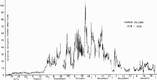 |
Figure 1. Graph showing the relative amplitude of volcanic tremor at Karkar, 1 July 1978-31 January 1979. For the most part, the amplitude is from the periodic stronger bands of tremor. Courtesy of C.O. McKee. |
"Investigations with a portable seismograph during August determined that the seismicity originated near the center of the island. Minor explosive sounds may have been heard on 25 August and possible minor ash was observed in the normal vapor column on 30 August. An extensive new area of thermal activity was noted on 31 August, but it is not clear when this commenced. Karkar residents were first advised on 4 September that an eruption was forecast. On 27 September, Karkar's activity increased. Red glow was observed and explosion sounds were heard, but no major eruption occurred."
Geological Summary. Karkar is a 19 x 25 km forest-covered island that is truncated by two nested summit calderas. The 5.5 km outer caldera was formed during one or more eruptions, the last of which occurred 9,000 years ago. The steep-walled 300-m-deep, 3.2 km diameter, inner caldera was formed sometime between 1,500 and 800 years ago. Cones are present on the N and S flanks of this basaltic-to-andesitic volcano; a linear array of small cones extends from the northern rim of the outer caldera nearly to the coast. Recorded eruptions date back to 1643 from Bagiai, a pyroclastic cone constructed within the inner caldera, the floor of which is covered by young, mostly unvegetated andesitic lava flows.
Information Contacts: R. Cooke, RVO.