Report on Soufriere St. Vincent (Saint Vincent and the Grenadines) — April 1979
Scientific Event Alert Network Bulletin, vol. 4, no. 4 (April 1979)
Managing Editor: David Squires.
Soufriere St. Vincent (Saint Vincent and the Grenadines) Major explosive eruption; 17,000 evacuated
Please cite this report as:
Global Volcanism Program, 1979. Report on Soufriere St. Vincent (Saint Vincent and the Grenadines) (Squires, D., ed.). Scientific Event Alert Network Bulletin, 4:4. Smithsonian Institution. https://doi.org/10.5479/si.GVP.SEAN197904-360150
Soufriere St. Vincent
Saint Vincent and the Grenadines
13.33°N, 61.18°W; summit elev. 1220 m
All times are local (unless otherwise noted)
A series of powerful explosions from Soufrière produced large ash clouds and several pyroclastic avalanches, forcing the evacuation of more than 17,000 persons from the N end of St. Vincent. This eruption is particularly noteworthy because of the wide variety of observations made by various scientific teams (from land, low-flying aircraft, a high-altitude research plane, and from satellites). When these data are analyzed and integrated, the geophysical community can look forward to an unusually well-documented account of an episode of explosive island-arc volcanism.
The first pre-eruption seismic event, telemetered to the Seismic Research Unit of the University of the West Indies by seismometers 3 and 9 km from Soufrière's summit, was a strong local earthquake at 1106 on 12 April, within 1 hour of the fortnightly earth tide maximum (calculated by F.J. Mauk). Seismic activity gradually increased through the day, and by 1900 about 15 clearly identifiable earthquakes, apparently B-type, were occurring per hour. Continuous harmonic tremor began to build an hour later, and within 2 hours was saturating the seismometers.
A team of volcanologists and seismologists from the Seismic Research Unit arrived on St. Vincent 13 April, and were later joined by researchers from several other institutions. The first explosive activity was observed at dawn (about 0500) on 13 April. Subsequent explosive events were reported at 1115, 1700, and 2050 on the 13th, 0300 and 1200 on 14 April, 1705 on 17 April, 0635 on 22 April, and 2355 on 25 April. Analysis of infrared imagery from NOAA's SMS-1 weather satellite indicates that most of these high eruption clouds were fed briefly (less than 1/2 hour) by the volcano. The largest of the clouds, from the 17 April explosion, reached an estimated height of 18 km and ultimately grew to a diameter of 140 km. The noon explosion on 14 April produced a 100 km-diameter cloud, and two explosions on 13 April also produced sizeable clouds, 60-km-diameter at 1700 and 40 km at 2050. The first two explosion clouds on 13 April were smaller, and the explosion reported at 0300 on 14 April produced no infrared signature. Most of the explosions occurred close to diurnal earth tide maxima, and the 17 April explosion also fell on the fortnightly earth tide minimum (calculations from F.J. Mauk).
A NASA P-3 Electra aircraft, equipped with lidar, a 10-stage quartz-crystal microbalance, and an NO2 remote-sensing instrument, flew through the periphery of the 17 April cloud minutes after it was ejected. Ash was collected and photographs were taken. The next evening, the NASA aircraft's lidar detected significant quantities of ejecta in the stratosphere, in patches 0.5-3 km thick with a base altitude of about 18.7 km. Scientists at NCAR, Kyushu University, and other institutions, will search at higher latitudes for stratospheric aerosols from this event.
Hot pyroclastic avalanches have accompanied at least three of the explosions. The largest avalanche flowed down the Larikai River valley (figure 1) at noon on 14 April and continued beyond the mouth of the river (3 km W of the crater) several kilometers out to sea. Its deposit at the coast was 1.5 m thick, ~300 m wide, and contained scoria blocks up to 60 cm in diameter. The surface temperatureof this deposit was well in excess of 100°C when it was inspected 28 hours after emplacement. A hot avalanche from one of the earlier explosions traveled 2.5 km SE from the summit, down the Rabacca Valley, and the 17 April explosion produced numerous hot avalanches that moved down several valleys on the flanks of the cone.
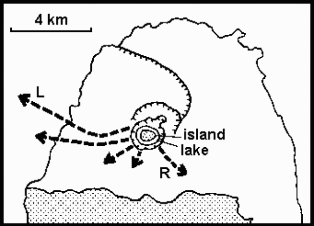 |
Figure 1. Sketch map of Soufrière and the N portion of St. Vincent, based on the map in the Catalog of Active Volcanoes of the World. Arrows show routes taken by pyroclastic avalanches, which traveled down valleys on Soufrière's flanks during at least three of the explosions in April 1979. Lengths are approximately proportional to distances traveled by the hot avalanches. Arrows labeled 1 and R indicate avalanches in the Larikai and Rabacca valleys. The lake and island (a lava dome extruded during the 1971 eruption) shown in Soufrière's summit crater were both destroyed during the present eruption. Rocks older than the Soufrière edifice are shown by a stippled pattern. |
Ashfalls from most of the explosions were limited to a few centimeters in the N portion of St. Vincent, and small amounts on Barbados, ~150 km E. However, during the 22 April eruption (figure 2) abnormal winds dropped 4 mm of ash on Kingstown (the capital of St. Vincent), on the S end of the island.
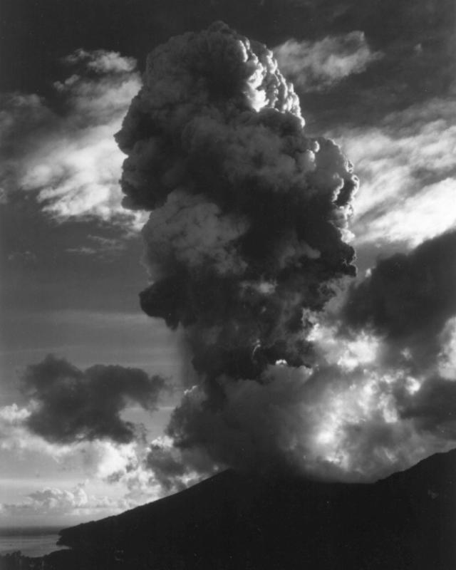 |
Figure 2. Photograph taken shortly after the onset of the 22 April 1979 explosion of Soufriere of St. Vincent. Height of the eruption cloud is estimated to be ~6 km. Photo taken by R. Fiske. |
The character of the seismic activity varied considerably during the eruption. Harmonic tremor continued to saturate the instruments from 2200 on 12 April through 1600 on 14 April. Beginning at about 0900 on the 15th, a decline in tremor amplitude made it possible to identify more than 100 individual events per hour at the station 9 km from the summit. The number of individual events declined irregularly through the morning of 16 April. At about 2000 on the 16th, the seismicity changed entirely to rock fracture events, which continued until the explosion of 17 April. After this explosion, the seismicity consisted primarily of 30-50 small explosion events per hour, which could be correlated with the ejection of steam puffs that sometimes contained a little ash. Most of the later explosions were preceded by brief periods (up to 3 hours) of seismic quiet. Seismicity ended almost completely at about 0300 on 29 April. With the exception of a 20-minute period of tremor during the night of 29-30 April, the volcano has remained seismically quiet through early 3 May.
. . . . The amount of tephra produced by the current eruption is about two orders of magnitude less than in 1902. . . .
Geological Summary. Soufrière St. Vincent is the northernmost and youngest volcano on St. Vincent Island. The NE rim of the 1.6-km wide summit crater is cut by a crater formed in 1812. The crater itself lies on the SW margin of a larger 2.2-km-wide caldera, which is breached widely to the SW as a result of slope failure. Frequent explosive eruptions after about 4,300 years ago produced pyroclastic deposits of the Yellow Tephra Formation, which cover much of the island. The first historical eruption took place in 1718; it and the 1812 eruption produced major explosions. Much of the northern end of the island was devastated by a major eruption in 1902 that coincided with the catastrophic Mont Pelée eruption on Martinique. A lava dome was emplaced in the summit crater in 1971 during a strictly effusive eruption, forming an island within a lake that filled the crater. A series of explosive eruptions in 1979 destroyed the 1971 dome and ejected the lake; a new dome was then built.
Information Contacts: J. Tomblin, W. Aspinall, K. Rowley, and J. Shepherd, UWI; A. Kreuger and R. LaPorte, NOAA; M. McCormick, NASA LaRC; F. Mauk, Univ. of Michigan; R. Fiske, SI.