Report on Asosan (Japan) — September 1979
Scientific Event Alert Network Bulletin, vol. 4, no. 9 (September 1979)
Managing Editor: David Squires.
Asosan (Japan) Large explosion kills three, then activity declines
Please cite this report as:
Global Volcanism Program, 1979. Report on Asosan (Japan) (Squires, D., ed.). Scientific Event Alert Network Bulletin, 4:9. Smithsonian Institution. https://doi.org/10.5479/si.GVP.SEAN197909-282110
Asosan
Japan
32.8849°N, 131.085°E; summit elev. 1592 m
All times are local (unless otherwise noted)
"Eruptive activity continued through early September. Ash eruptions occurred almost every day from mid-July until 10 August (table 1) and ash fell on towns near the volcano; ash reached Takeda City, 30 km NE of Aso, in early August. Strong rumbling resumed on 10 August, but the volcano suddenly stopped emitting ash at about 1300 that day. The rumbling lasted until 26 August and was occasionally heard at the towns of Aso-machi and Ichino-miya-machi, 10 km from the crater. A steep decrease in the amplitude of the recorded continuous tremor took place at about 0900 on 27 August and the volcano was very quiet (no ash or block ejection, nor any rumbling) until 6 September.
"A loud explosion occurred at 1306 on 6 September. A dark ash cloud, in which lightning was seen, rose 700 m. The air shock reached 0.8 millibars and the ground shock had an amplitude of 17 µm at the JMA's Aso Observatory, 1.2 km from the crater. Three tourists were killed, two injured seriously, and nine slightly, by falling blocks 10-20 cm in diameter at a site 0.9 km from the vent (figure 4). Numerous blocks pierced the roof of a ropeway station (also 0.9 km from the vent), made of concrete as thick as 25 cm. A few of the lesser injuries occurred inside the station house. People said that the blocks that fell around the station house were hot and the cores of some of them were dimly glowing. Ash reached Oita city, 65 km NNE of Aso. The activity declined to white vapor emission 7 minutes after the explosion and no further eruption had occurred as of 12 September.
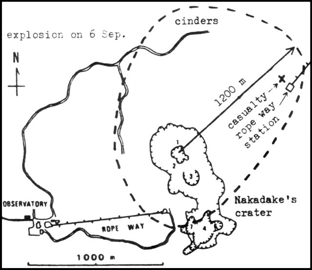 |
Figure 4. Summit area of Aso. Casualities from the 6 September 1979 explosion took place at the site marked X. Cinders larger than 3 cm fell in the area enclosed by a dashed line, a maximum of 1,200 m from the vent, Crater 1 of Naka-dake. Craters 1-7 are shown within the larger Naka-dake Crater, by hachured lines. Courtesy of JMA. |
"The amplitude of recorded continuous tremor remained small (about 2 µm) through the explosion, became large (to 17 µm) 40 minutes after the explosion, then declined gradually to around 5 µm 14 hours after the explosion. It is not known whether the low-amplitude stage, which lasted from 27 August to just after the explosion, was an example of `amplitude decrease prior to explosion' (4:8). Seismicity remained relatively low both before and after the explosion.
"The restricted area [designated] on 11 June by the local disaster control committee for Aso volcano was still [closed] on 6 September. The committee will reexamine the size of the restricted area (within 1 km of the crater), although the casualties occurred in this area.
"The summit area of Naka-dake was surveyed by JMA personnel and by Koji Ono of the Japan Geological Survey 8-11 September. Cinders larger than 3 cm were scattered in the area enclosed by a dashed line in figure 4, reaching 1.2 km from Crater 1. A large block found 0.3 km from Crater 1 was 4.6 x 2.6 x 2.6 m and weighed about 50 metric tons. No scoria or other essential fragments were found. The explosion is considered to be a steam explosion, and may have been caused by heavy rainfalls on 27 August (161 mm) and 3-4 September (127 mm)."
Further Reference. Wada, T., Kikuchi, S., and Ono, H., 1980, The explosion of Naka-dake, volcano Aso on the 6th of September, 1979: Bulletin of the Volcanological Society of Japan, v. 25, p. 245-253.
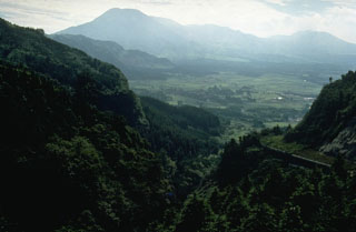
Geological Summary. The 24-km-wide Asosan caldera was formed during four major explosive eruptions from 300,000 to 90,000 years ago. These produced voluminous pyroclastic flows that covered much of Kyushu. The last of these, the Aso-4 eruption, produced more than 600 km3 of airfall tephra and pyroclastic-flow deposits. A group of 17 central cones was constructed in the middle of the caldera, one of which, Nakadake, is one of Japan's most active volcanoes. It was the location of Japan's first documented historical eruption in 553 CE. The Nakadake complex has remained active throughout the Holocene. Several other cones have been active during the Holocene, including the Kometsuka scoria cone as recently as about 210 CE. Historical eruptions have largely consisted of basaltic to basaltic andesite ash emission with periodic strombolian and phreatomagmatic activity. The summit crater of Nakadake is accessible by toll road and cable car, and is one of Kyushu's most popular tourist destinations.
Information Contacts: JMA.