Report on Sierra Negra (Ecuador) — November 1979
Scientific Event Alert Network Bulletin, vol. 4, no. 11 (November 1979)
Managing Editor: David Squires.
Sierra Negra (Ecuador) 14-km-high cloud; lava flows to sea
Please cite this report as:
Global Volcanism Program, 1979. Report on Sierra Negra (Ecuador) (Squires, D., ed.). Scientific Event Alert Network Bulletin, 4:11. Smithsonian Institution. https://doi.org/10.5479/si.GVP.SEAN197911-353050
Sierra Negra
Ecuador
0.83°S, 91.17°W; summit elev. 1124 m
All times are local (unless otherwise noted)
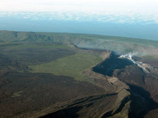
An eruption began on 13 November at Sierra Negra, the only historically active volcano in the Galápagos Islands that is presently inhabited. The location was Volcán Chico, a circumferential fissure zone 1 km N of, and 100-200 m below, the caldera rim of Sierra Negra. Volcán Chico was also the site of the last two eruptions from this volcano, in 1963 and 1953, and has been described by Delaney and others (1973). At the time of the last report lava was still flowing down the volcano's uninhabited N slope 3 weeks after it began. The residents of the S slope, evacuated on the first day of the eruption, had returned to find damaged crops and livestock.
At 0730 on 13 November a local earthquake was registered on the CDRS seismograph (90 km E of Sierra Negra on Isla Santa Cruz), part of the WWSSN maintained by the USGS [see also 4:12]. A second, larger, earthquake followed in 20 minutes, and at 0845 the first explosion was heard by people living on the S flank. Within 20 minutes of the first explosion, tephra (including scoria and Pele's hair) fell on the villages of Santo Tomás and Villamil, 13 and 26 km SE of the eruption site. Residents of Santo Tomás began evacuation to the coastal village of Villamil.
The eruptive cloud was large enough to be seen on NOAA's SMS-1 weather satellite, which transmits images of the whole hemisphere every 30 minutes from its equatorial geostationary orbit. The cloud first appeared on the 0930 image and grew rapidly to an area estimated to be 220 x 130 km within 2 hours. The cloud soon separated into two lobes and measurements on the infrared imagery by Arthur F. Krueger indicate a maximum elevation of at least 14 km for the main lobe at 1500. This lobe moved SE at 25 km/hour while the other lobe, estimated to be about 8 km high, moved SW at 30 km/hour. By 2200, the main lobes were quite diffuse, but a low, thin plume (near the 4-8 km resolution of the imagery) extended about 50 km S from Sierra Negra. No prominent eruptive clouds were visible on SMS-1 imagery during the following days.
A CDRS team (including P. Ramón, J. Budris, and T. & A. Moore) reached Volcán Chico 24 hours after the eruption began. Upon arrival at Villamil, they noted a thin coating of tephra with some light scoria fragments to 5 cm in diameter. Tephra at the caldera rim was 2-3 cm thick, with some 15-20-cm bombs, but nothing larger than 1 cm was falling at the time. Up to 20 vents were active along the 1-2-km [8 km, see 5:1] circumferential fissure and individual fountains reached 100-m heights. As many as 13 lava flows coalesced downslope to the N and probably reached the sea on the first day. Billowing clouds were visible at the coast of Elizabeth Bay on the morning of 15 November, and two biological groups were reported to be investigating the lava/sea interface.
At 1500 on 14 November, a higher resolution NOAA satellite, VHRR Tiros 6, returned an infrared image showing the lava flow on the N flank and a high vapor plume heading S. The CDRS seismograph recorded 8 local events on 14 November and 6 on the following day. Observers at the site felt many tremors, but noted that eruptive intensity seemed to decrease after a peak around 2200-2300 on 14 November. Local haze increased during the next 2 days and vent activity declined steadily. Only four vents were active and fountaining had almost stopped by sunset on 16 November. At 0400 the next morning, however, observers were awakened by the largest explosion of their 5 days at the site. Fountaining increased immediately and continued to build to a peak around 5 hours later. That same night the wind changed, carrying haze ENE over Isla Santa Cruz and reducing visibility there to 2 km on 19 November.
Activity at the vents remained low on 18 and 19 November, when the group left. The flows continued, however, and on the morning of 19 November, NASA's Landsat C satellite returned a high-resolution near-infrared image clearly showing the main flow as a 100 m band bearing 030° for about 12 km from the vent area (figure 1). On that same day, tephra fragments to 5 mm in diameter were collected on the ship Delfin, over 100 km E of the volcano.
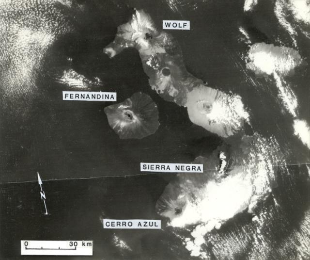 |
Figure 1. Western Galapagos Islands on 19 November 1979, the 7th day of the Sierra Negra eruption. A 130 x 165 km area is shown (a joined pair of Landsat C images). The large cloud near the base of the figure obscures the summit and S flank of Sierra Negra, but a prominent white eruptive cloud trends NNE from the eruption site near the volcano's N rim and a lava flow appears just E of the cloud as a thin white band trending NE for 12 km. The near-infrared image (Band 7) shows the vegetated portions of these volcanic islands as light gray, in contrast to the dark young lavas. Summit calderas of most volcanoes are visible. Images provided by NASA/GSFC (ID's: PAO file E-931-225BN and E-932-225BN). |
As the CDRS group left the volcano, they noted an average tephra thickness of 3-5 cm on the caldera rim and serious damage to the biota on the upper SE flank. Acid rain and haze killed much vegetation and the group noted dead birds and rats. Residents of the S flank, who returned to their farms after the eruption's first day, reported damage to crops and livestock.
H. Hoeck was on the volcano 1-2 December and reported that the vegetation was beginning to recover. One large lava flow continued down the N slope, and several vents were steaming. Six small vapor vents were observed on the S floor of the caldera nearly 10 km S of the eruptive fissure. This caldera, the widest (10 x 7 km) and shallowest in the Galápagos, was not otherwise affected by the eruption, and Arnaldo Tupiza (CDRS representative on Isabela and very familiar with the volcano) recognizes these six vents as new.
None of the eruption earthquakes have yet been located on the WWSSN [but see 4:12], but a magnitude 5.0 event was located in the Galápagos at 1006 on 28 October. Its preliminary epicenter determination is 60 km NW of the eruption site.
Geological Summary. The broad shield volcano of Sierra Negra at the southern end of Isabela Island contains a shallow 7 x 10.5 km caldera that is the largest in the Galápagos Islands. Flank vents abound, including cinder cones and spatter cones concentrated along an ENE-trending rift system and tuff cones along the coast and forming offshore islands. Although it is the largest of the five major Isabela volcanoes, it has the flattest slopes, averaging less than 5° and diminishing to 2° near the coast. A sinuous 14-km-long, N-S-trending ridge occupies the west part of the caldera floor, which lies only about 100 m below its rim. The Volcán de Azufre fumarolic area lies within a graben between this ridge and the west caldera wall. Lava flows from a major eruption in 1979 extend all the way to the north coast from circumferential fissure vents on the upper northern flank.
Information Contacts: P. Ramón, J. Budris, H. Hoeck, P. López, and J. Villa, CDRS, Galápagos; M. Hall, Escuela Politécnica, Quito; A. Krueger, NOAA/NESS; C. Wood, NASA/GSFC; B. Presgrave, USGS/NEIS, Denver, CO.