Report on Sierra Negra (Ecuador) — December 1979
Scientific Event Alert Network Bulletin, vol. 4, no. 12 (December 1979)
Managing Editor: David Squires.
Sierra Negra (Ecuador) Eruption ends; additional earthquakes located
Please cite this report as:
Global Volcanism Program, 1979. Report on Sierra Negra (Ecuador) (Squires, D., ed.). Scientific Event Alert Network Bulletin, 4:12. Smithsonian Institution. https://doi.org/10.5479/si.GVP.SEAN197912-353050
Sierra Negra
Ecuador
0.83°S, 91.17°W; summit elev. 1124 m
All times are local (unless otherwise noted)
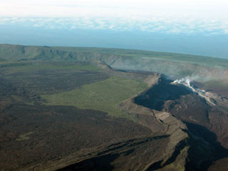
The fissure eruption was continuing on 5 December. LANDSAT imagery on 7 December, however, showed no thermal anomaly like the lava flow on the 19 November LANDSAT image (figure 1), although a vapor cloud similar to that of 19 November was present. When Arnaldo Tupiza visited the eruption site on 29 December, the lava flow had ceased, but the vents continued to steam and the solfataric area had grown. The new fumaroles on the S caldera floor remained active.
Two earthquakes connected with this eruption have been located by USGS/NEIS. The first, at 0751 on 13 November [4:11], was magnitude 4.4 and its hypocenter (0.89°S, 91.23°W) was located 18 km SW of the eruption site. This was followed at 0817 by another earthquake that wrote a very similar, and only slightly smaller, record on the CDRS seismograph 90 km to the E. This event has not been located by NEIS, but was followed in less than 30 minutes by the first explosion recognized on the island. Seismicity increased on the eruption's second afternoon, and at 1858 on 15 November, a magnitude 4.8 event was recorded. Its hypocenter (0.96°S, 91.25°W) was located by NEIS 24 km SSW of the eruption site. These hypocenters are in the area of the February 1979 flank eruption of Cerro Azul [4:1-2], but study of the 1968 caldera collapse earthquakes from Fernandina (Filson et al., 1973), where true epicenters were known, showed that hypocenter mislocations for events of this magnitude range averaged about 50 km.
Reference. Filson, J., Simkin, T., and Leu, L.-K., 1973, Seismicity of a caldera collapse: Galápagos Islands 1968: JGR, v. 78, no. 35, p. 8591-8622.
Geological Summary. The broad shield volcano of Sierra Negra at the southern end of Isabela Island contains a shallow 7 x 10.5 km caldera that is the largest in the Galápagos Islands. Flank vents abound, including cinder cones and spatter cones concentrated along an ENE-trending rift system and tuff cones along the coast and forming offshore islands. Although it is the largest of the five major Isabela volcanoes, it has the flattest slopes, averaging less than 5° and diminishing to 2° near the coast. A sinuous 14-km-long, N-S-trending ridge occupies the west part of the caldera floor, which lies only about 100 m below its rim. The Volcán de Azufre fumarolic area lies within a graben between this ridge and the west caldera wall. Lava flows from a major eruption in 1979 extend all the way to the north coast from circumferential fissure vents on the upper northern flank.
Information Contacts: A. Tupiza and H. Hoeck, CDRS, Galápagos; USGS/NEIS, Denver, CO.