Report on Shishaldin (United States) — September 1981
Scientific Event Alert Network Bulletin, vol. 6, no. 9 (September 1981)
Managing Editor: Lindsay McClelland.
Shishaldin (United States) Plumes accompany eruption at nearby Pavlof
Please cite this report as:
Global Volcanism Program, 1981. Report on Shishaldin (United States) (McClelland, L., ed.). Scientific Event Alert Network Bulletin, 6:9. Smithsonian Institution. https://doi.org/10.5479/si.GVP.SEAN198109-311360
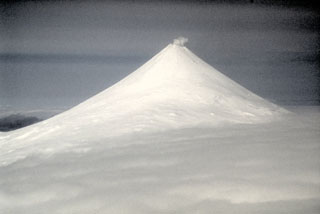
Shishaldin
United States
54.756°N, 163.97°W; summit elev. 2857 m
All times are local (unless otherwise noted)
Activity accompanied some of the eruption at Pavlof (about 150 km ENE) [see 6:9 Pavlof; Pavlof and Shishaldin are in different time zones]. At 1315 on 25 September, NOAA weather satellite imagery revealed plumes emerging from both Shishaldin and Pavlof (Pavlof was also emitting a plume 4 hours earlier when weather clouds had last allowed a clear view of the area). By 1445, Shishaldin's plume had reached an altitude estimated at 6-7.5 km based on cloud top temperatures calculated from infrared imagery. The plume remained evident on the imagery until 1845, drifting E.
However, no activity from Shishaldin accompanied the ejection of a new cloud from Pavlof at 1845. Satellite images next showed a plume from Shishaldin at 0830 the next morning, when plumes from both volcanoes could be seen drifting ESE. On the next image with clear visibility, at 1315, no activity could be seen from Shishaldin. Reports from pilots through this period were very sketchy, but Shishaldin was said to be "steaming hard." No unusual activity was observed after 26 September by pilots or on satellite imagery.
Geological Summary. The symmetrical glacier-covered Shishaldin in the Aleutian Islands is the westernmost of three large stratovolcanoes in the eastern half of Unimak Island. The Aleuts named the volcano Sisquk, meaning "mountain which points the way when I am lost." Constructed atop an older glacially dissected edifice, it is largely basaltic in composition. Remnants of an older edifice are exposed on the W and NE sides at 1,500-1,800 m elevation. There are over two dozen pyroclastic cones on its NW flank, which is covered by massive aa lava flows. Frequent explosive activity, primarily consisting of Strombolian ash eruptions from the small summit crater, but sometimes producing lava flows, has been recorded since the 18th century. A steam plume often rises from the summit crater.
Information Contacts: T. Miller and J. Riehle, USGS, Anchorage; S. McNutt and E. Hauksson, LDGO; W. Younker, NOAA/NESS, Anchorage.