Report on Sarychev Peak (Russia) — December 1981
Scientific Event Alert Network Bulletin, vol. 6, no. 12 (December 1981)
Managing Editor: Lindsay McClelland.
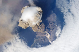
Sarychev Peak (Russia) Intensely active fumaroles in center of summit crater
Please cite this report as:
Global Volcanism Program, 1981. Report on Sarychev Peak (Russia) (McClelland, L., ed.). Scientific Event Alert Network Bulletin, 6:12. Smithsonian Institution. https://doi.org/10.5479/si.GVP.SEAN198112-290240
Sarychev Peak
Russia
48.092°N, 153.2°E; summit elev. 1496 m
All times are local (unless otherwise noted)
The W walls of the crater were ruined after the 1976 eruption, and this part of the summit was flat during the 20 September overflight. In the central part of the summit crater, there was a shallow but morphologically distinct funnel in which there were many intensely active fumaroles.
Geological Summary. Sarychev Peak, one of the most active volcanoes of the Kuril Islands, occupies the NW end of Matua Island in the central Kuriles. The andesitic central cone was constructed within a 3-3.5-km-wide caldera, whose rim is exposed only on the SW side. A dramatic 250-m-wide, very steep-walled crater with a jagged rim caps the volcano. The substantially higher SE rim forms the 1496 m high point of the island. Fresh-looking lava flows, prior to activity in 2009, had descended in all directions, often forming capes along the coast. Much of the lower-angle outer flanks of the volcano are overlain by pyroclastic-flow deposits. Eruptions have been recorded since the 1760s and include both quiet lava effusion and violent explosions. Large eruptions in 1946 and 2009 produced pyroclastic flows that reached the sea.
Information Contacts: G. Steinberg, Sakhalin Complex Institute.