Report on El Chichon (Mexico) — July 1982
Scientific Event Alert Network Bulletin, vol. 7, no. 7 (July 1982)
Managing Editor: Lindsay McClelland.
El Chichon (Mexico) Stratospheric cloud continues N dispersal
Please cite this report as:
Global Volcanism Program, 1982. Report on El Chichon (Mexico) (McClelland, L., ed.). Scientific Event Alert Network Bulletin, 7:7. Smithsonian Institution. https://doi.org/10.5479/si.GVP.SEAN198207-341120
El Chichon
Mexico
17.3602°N, 93.2297°W; summit elev. 1150 m
All times are local (unless otherwise noted)
The major stratospheric cloud remained dense over lower northern latitudes. It has been estimated to cover the earth from S of the equator to as far N as Japan between 21 and 33 km altitude and to average 9.6 km thick. Lidar measurements and reports from England indicated that gradual northward dispersal was continuing.
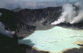
Geological Summary. El Chichón is a small trachyandesitic tuff cone and lava dome complex in an isolated part of the Chiapas region in SE México. Prior to 1982, this relatively unknown volcano was heavily forested and of no greater height than adjacent non-volcanic peaks. The largest dome, the former summit of the volcano, was constructed within a 1.6 x 2 km summit crater created about 220,000 years ago. Two other large craters are located on the SW and SE flanks; a lava dome fills the SW crater, and an older dome is located on the NW flank. More than ten large explosive eruptions have occurred since the mid-Holocene. The powerful 1982 explosive eruptions of high-sulfur, anhydrite-bearing magma destroyed the summit lava dome and were accompanied by pyroclastic flows and surges that devastated an area extending about 8 km around the volcano. The eruptions created a new 1-km-wide, 300-m-deep crater that now contains an acidic crater lake.
Information Contacts: W. Fuller, NASA; M. Hirono, Kyushu Univ., Japan; H. Lamb, Univ. of East Anglia, England.