Report on Soputan (Indonesia) — August 1982
Scientific Event Alert Network Bulletin, vol. 7, no. 8 (August 1982)
Managing Editor: Lindsay McClelland.
Soputan (Indonesia) Explosions eject large plumes
Please cite this report as:
Global Volcanism Program, 1982. Report on Soputan (Indonesia) (McClelland, L., ed.). Scientific Event Alert Network Bulletin, 7:8. Smithsonian Institution. https://doi.org/10.5479/si.GVP.SEAN198208-266030
Soputan
Indonesia
1.112°N, 124.737°E; summit elev. 1785 m
All times are local (unless otherwise noted)
An explosive eruption began 26 August at 1142. Ash rose to 3 km above the summit crater at 1300. Ash fell on a village 7 km SE of the volcano and lightning was observed at night. Detonations and roaring sounds followed the explosions. The 850 inhabitants of a village on the flanks of the volcano moved to nearby towns. Indonesian authorities issued a warning notice to aircraft.
An image returned by the GMS satellite at 1400 showed a fairly dense plume, ~120 km in diameter, emerging from Soputan. Four hours later, a Cathay Pacific Airlines pilot estimated that the top of the cloud was at ~15 km, well above his flight altitude. At 2000, a satellite image showed continued vigorous feeding of the plume, which extended ~700 km W from the volcano to 119°E, where it was ~350 km wide. On this image, the plume appeared to be rising to roughly the cirrus cloud level, in the upper troposphere. By midnight, feeding of the plume was weakening, and on the next image, at 0200 on 27 August, the plume was detached from the volcano.
Satellite imagery showed renewed activity shortly before 0800. A plume about the same size as the one ejected the previous day moved W. Light ashfall started at 0915 on a town about 40 km N of the volcano. Feeding of the plume continued until about 1400. An additional seismograph was installed 27 August at a site 5 km S of Soputan.
Antara radio reported a third, smaller, explosive episode 28 August. Hot ash, but no large tephra, was ejected from dawn to about midday, accompanied by thunderous sounds. Ash fell on 12 villages around the volcano, but there were no casualties. No additional explosions were reported until 16 September, when an eruption plume appeared on satellite imagery. Antara reported five explosions that day.
Geologists had visited the volcano two days before the eruption began but saw no increased surface activity. They measured fumarole temperatures of 76°, 79°, and 84°C. Soputan last erupted in 1973.
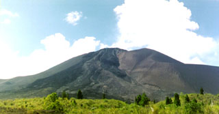
Geological Summary. The Soputan stratovolcano on the southern rim of the Quaternary Tondano caldera on the northern arm of Sulawesi Island is one of Sulawesi's most active volcanoes. The youthful, largely unvegetated volcano is the only active cone in the Sempu-Soputan volcanic complex, which includes the Soputan caldera, Rindengan, and Manimporok (3.5 km ESE). Kawah Masem maar was formed in the W part of the caldera and contains a crater lake; sulfur has been extracted from fumarolic areas in the maar since 1938. Recent eruptions have originated at both the summit crater and Aeseput, a prominent NE-flank vent that formed in 1906 and was the source of intermittent major lava flows until 1924.
Information Contacts: A. Sudradjat, VSI; T. Baldwin, D. Haller, and M. Matson, NOAA; Antara News Agency, Jakarta.

